Tena kotoe katoa and welcome back to the Upoko o te Ika a Maui. After a brief holiday, I’m back. While I’ve been off relaxing, Philip has been hard at work, planning and redesigning the website, adding in a search button so that you can search by key-words for key subject areas, giving it a more modern funky interface, and most wonderful of all to me: removing all the spam. That’s magic! But there’s only one story ready to tell right now, and it is set to be a mighty showdown.
Now, that’s what we want to see! No, not just our splendid new website design (thanks Philip!!) but the battle over Motu Kairangi – or the Miramar Peninsula. Unless you’ve been living under a rock in the harbour, like a giant Taniwha, you will be aware that the developer’s proposal for Shelly Bay has been a bit controversial over the past few years. And now there is an alternative proposal.
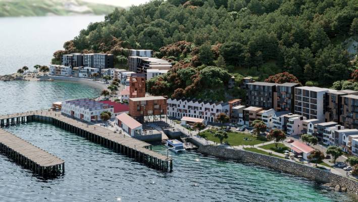
Let’s look back at the history of the place. Easier said than done – the history is convoluted. Perhaps it is easier to say: land was taken under the Defence Act for the purposes of a Naval Base, but this has lapsed many years ago. The buildings on the base have also lapsed, in most cases lapsing sideways into the sea. Despite its undeniable romanticism of the derelict wharf buildings, the truth is that a complete lack of upkeep in one of the more hostile marine conditions in the capital, mean that most of the buildings and wharfs on the site are shot.
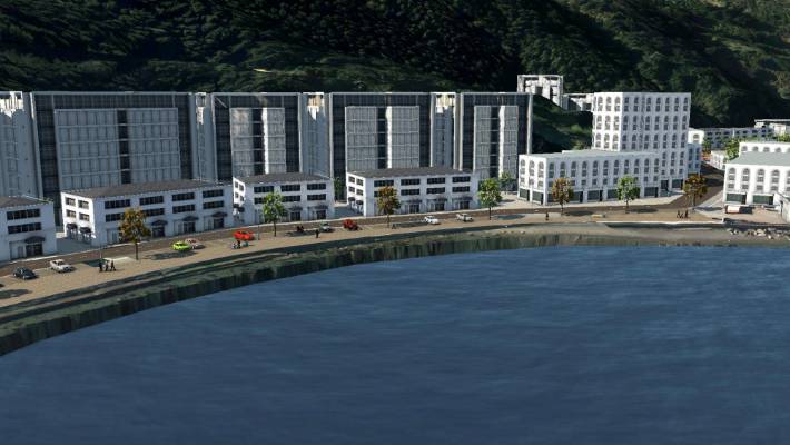
Defence moved out, Government offered the land back to the original owners – ie Maori local iwi, with other areas owned by WCC. Land swaps, back room deals, all the usual drama: end result is that local developer Ian Cassells of The Wellington Company (TWC) is now the developer of the waterfront scheme at Shelly Bay. There is more to it than that, of course, much more, but the gist of it is that not everyone agrees that TWC has the right to be there, to do that development. Including some of the iwi who feel they were shafted, and including many of the citizens of this city, who feel that if they haven’t been shafted yet, then very soon they will be.
Enter the dragon – no, enter the taniwha. In fact, two of them: Ngake and Whātaitai the taniwha of Wellington harbour.
“Once long ago, before the time of Kupe, when Te Ika-a-Māui was just fished from the depths of the ocean, there lived two taniwha, Ngake and Whātaitai. In those times, Wellington Harbour, Te Whanganui-a-Tara, was a lake cut off from the sea, and abundant in fresh water fish and native bird life. Ngake and Whātaitai lived here in the lake at the head of the fish of Māui (Te Ika-a-Māui).
Ngake and Whātaitai had a great life in their special lake, with all the time in the world to do as they pleased. Ngake was a taniwha with lots of energy. He liked to race around the shores, chasing fish and eels and leaping after birds that came too close. Whātaitai was the opposite, he preferred to laze on the lake’s shores, sunbathing and dreaming taniwha dreams…..

…..One morning there was a dreadful shudder beneath the ocean floor. A huge earthquake erupted. Whātaitai was lifted out of the shallow water and high above sea level. Whātaitai could do nothing, he was stranded high above the water and he knew his life would end. Whātaitai bade farewell to his many bird friends and animals and soon after gasped his final breath.
As he died, Whātaitai’s spirit transformed into a bird, Te Keo, and flew to the closest mountain, Matairangi (Mount Victoria). Te Keo looked down on the huge taniwha body that stretched across the raised sea bed and cried. She cried for the great friendships Whātaitai had made, shown by the huge numbers of birds and sea life that had gathered around, and for the freedom of the sea which Whātaitai would never experience. When Te Keo had completed her lament, she bade farewell to Whātaitai, then set off to the taniwha spirit world. Over the years Whātaitai’s body turned to stone, earth and rock and is known to this day as Haitaitai. Matairangi still looks down on the body of Whātaitai and the very top of Matairangi is still known as Tangi te Keo.
When Ngake let the spring in his tail loose he used so much force that he created a great gash in the earth and a river was formed. This river is now called Teawakairangi or the Hutt River. The remnants of rock smashed aside when Ngake exited into the sea are visible today and Te Aroaro o Kupe (Steeple Rock) and Te Tangihanga o Kupe (Barrett’s Reef) have long been known as dangerous rock formations to mariners entering the Wellington harbour.
Although Ngake was never seen again it is still believed that he resides in the turbulent waters of the Te Moana o Raukawa (Cook Strait). When the sea is calm Ngake is off exploring Te Moana Nui a Kiwa (the Pacific Ocean). When the sea is turbulent and rough, Ngake is at home chasing sea life to satisfy his taniwha appetite. And this is the story of Ngake and Whātaitai, the taniwha of the Wellington harbour, with thanks to Wiremu Grace.“
So the huge full colour double page spread in Saturday’s paper advertising the alternative scheme for the area is a Pretty Big Deal. The Motu Kairangi Design Group has proposed an alternative vision for the peninsula, one that does not involve numerous mid-rise apartment buildings. Instead, it offers an overall vision for the entire north half of the peninsula : across the vast bulk of Whātaitai, who lies still in the harbour.
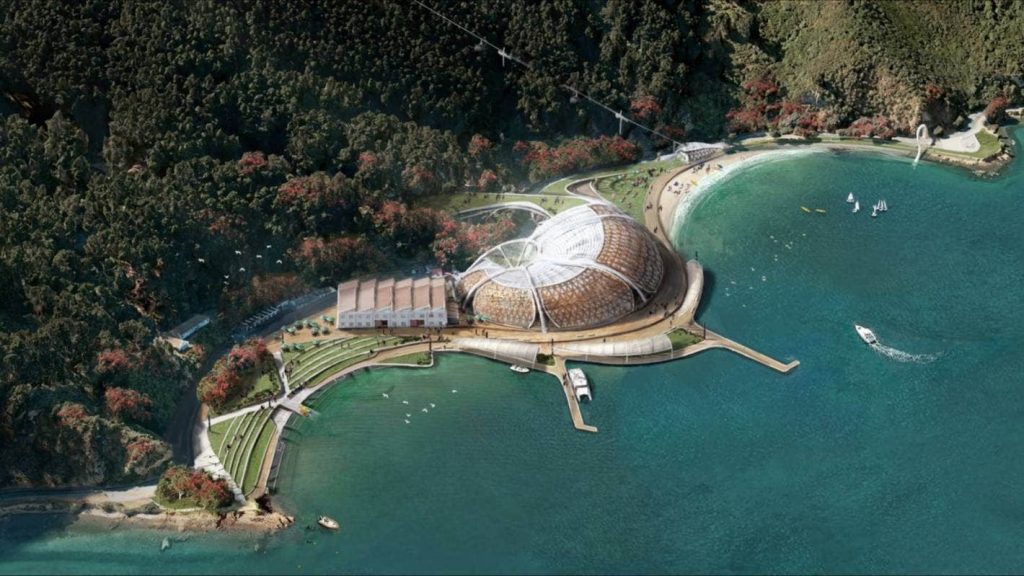
There is a waharoa at the entry, an eco-tourist research and education centre, a cultural centre, a military museum, a feature sculpture area, walkways, a gondola up a hill, pathways, walkways, bike ways, and so much more.
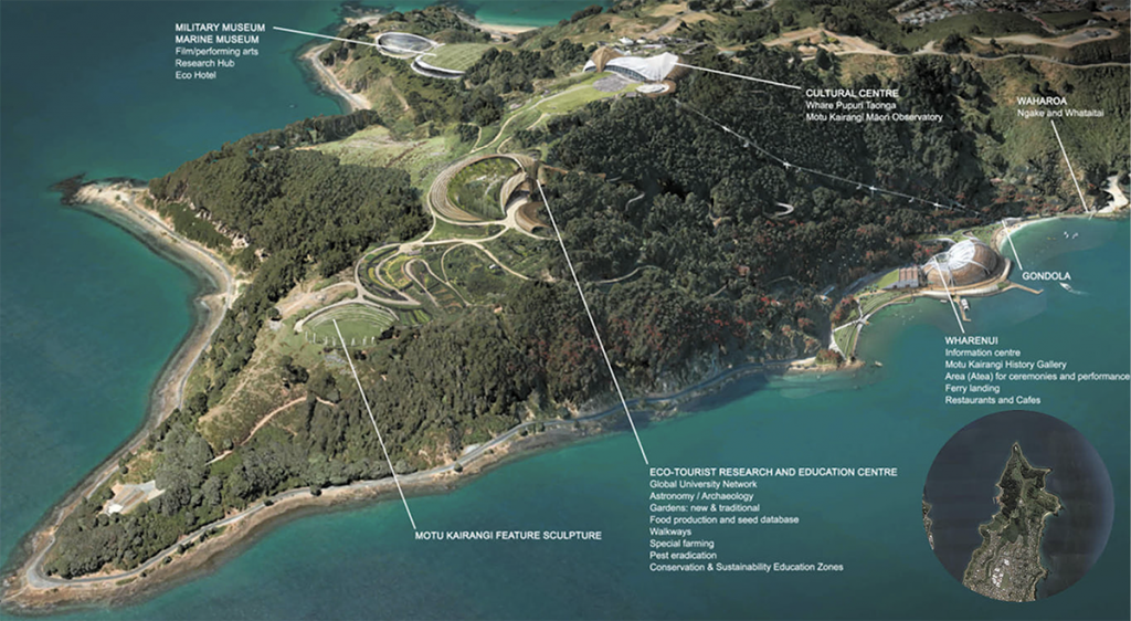
The question now is: what next? There is millions at stake here. Cassells is saying that he wishes they had come and talked to him at the time (but many have tried that, to no avail: Cassells knows best). Architecture + the architects of the Cassells design are probably keeping quiet, which is a pity, and it would be good to get their honest opinion on the new scheme. Some members of the public are of course going to say: good on you if you are going to stop those hideous Soviet era skyscrapers, except that I can tell you that we’ve discussed that before, and they’ve certainly not Soviet era high-rises. “We need to talk about Shelly” and so we did.
The design quality of the proposed scheme is fantastic – vibrant fresh ideas and would make Wellington far more of a destination that would another upmarket subdivision, but there is one big question laying all over this proposal at the first glance: who’s gonna pay?
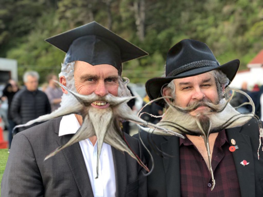


I guess these people aren’t worried about transport, or sea level rise, or cost to council or many of the other issues that have been raised with regard to the Cassels project which would also apply to this.
This is This is an alternative vision, sea level will be a big consideration, traffic will be going against the flow of the traffic and not in peak times.
Funding,,,have you actually thought that this will not only be a smaller part funded by WCC ratepayers but funding will be from a wide range of large corporate companies creating an ongoing income for IWI and WCC plus the city will benefit from visitors staying for longer periods of time, they will have Zealandia, Te Papa and National Heritage Park…
Good point Connor – and yes, of course, the issues around sea level rise will apply equally to both schemes. Either way, both of the proposals would have to rebuild the sea wall and probably raise up the site levels a bit to avoid getting wet feet over the years. Transport, however, is a different issue in my eyes, and it is one of the major stumbling blocks with the Wellington Company scheme. It would be great if Stuart Gardyne could comment in here, because he will know more about this than me, but the thing about having the site as a residential haven is that while a lot of the owners will be rich and retired, presumably at least some of them will have to go to work, and they may not all be zooming… In other words, at 8.00am there will be a stream of cars tootling south along the skinny road, and trying to join in the stream of cars coming from Miramar and heading towards the city. Not only is somehow the city meant to be putting its hand up for that (seems unfair), but it is only going to make a bad situation far worse, and that is something that no-one seems prepared to admit and take seriously.
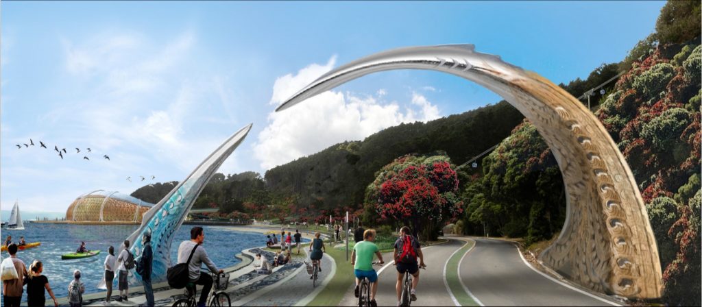
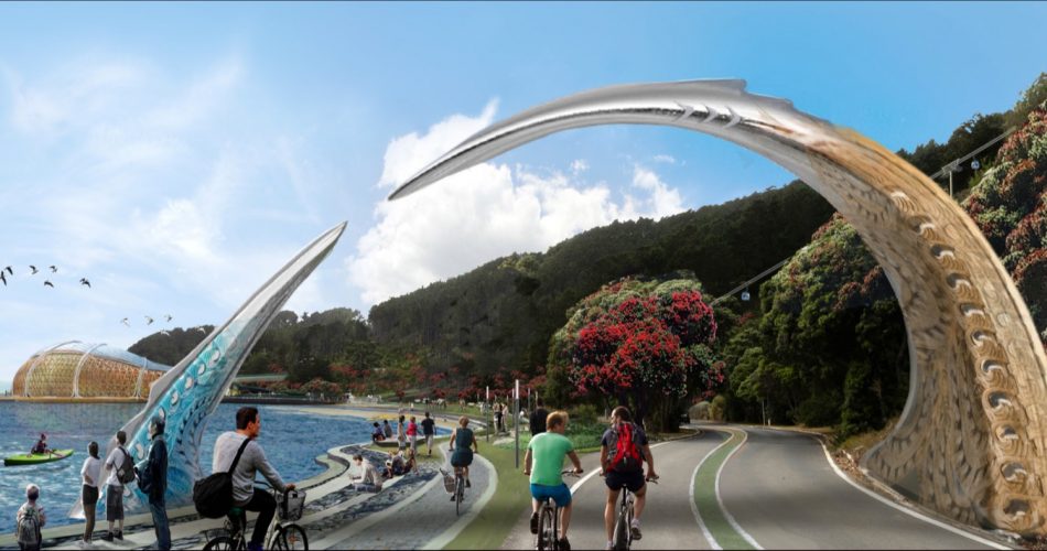
But with this new scheme, the visitor numbers are likely to be quite different, and possibly travelling in the opposite direction. Maybe also likely to be spaced out a lot more through the day. The picture at the Waharoa up the top shows a lovely idyllic scene with many people, all on foot, on bicycle, or on kayak, but conspicuous by their absence are cars. No cars at all – despite the road obviously set up for them. Artistic license, of course, but the truth remains: who is paying for the new road, in either scheme?
Actually, this is the biggest question about the Motu Kairangi Design Group scheme: where does the money come from?
Full disclosure: I haven’t read everything to do with the Design Group scheme (just read the thing on Stuff and this post and looked at the infographics).
Re. transport, my understanding with respect to the WC scheme was that it would include a commuter ferry (well you can argue about whether or not that is a good idea or would be well-used). Anyway, if the north peninsula were to become such a large attraction a ferry link to Queen’s Wharf might not be a bad idea if it was marketed as a tourist trip (especially as it would have great views of the CBD waterfront and Oriental Bay).
In addition, the graphics above don’t show the Massey memorial incorporated into any development – whether or not you think Massey himself should be venerated (c.f. the Massey Uni naming story the media picked up a couple of years ago) the actual positioning of the memorial offers excellent views north and is situated right on the straight line from the tip of the peninsula to the “feature sculpture” so should probably be connected to both (via bush walks or something similar) so that pedestrians don’t have to use the road.
Anyway, in the unlikely event it comes off it looks like it might become a “new botanic gardens” in being a cross between an outdoors area with bush, gardens, and sculptures, and a setting for museums and other such attractions.
Thanks for that m28a31 – yes, they have been a bit under the radar, so to speak. I’m sure we are going to hear more from them in the future though! The commuter ferry is a welcome addition and the best, most logical move to get to hat site. Doesn’t work so well if you are commuting in from Shelly Bay, but the ferries will love a chance to go out during the day to take tourists (if they ever return) out to the new gardens at Motu Kairangi. Re the Massey Memorial – I can see the memorial in their site plan, but you’re right, it isn’t specifically mentioned and brought out into the open. I have this sneaking suspicion that it will all get linked up through the bush.
There are a number of issues and misconceptions to numinous to state here Conor. The housing development will only add to peck hour traffic congestion where a tourist destination is off peak. Ian Cassells The Wellington Company has his eye on another large area of land and a housing development on and around the prison site which will again only exasperate peak hour congestion. Have a look at this link put up by the concerned Peninsula parents group when they ran their council petition against additional rate payers land being sold and leased to Ian Cassells and his wife. This vote is happening next month.
https://www.youtube.com/watch?v=bvX-AJC1wQY&feature=youtu.be
The design groups offering is to all people and future generations as apposed to one developer, his wife, their financial investors and 350 residential owners. What do you think the majority of people in this city would like to be part of
I can’t see how anything can be developed here without funding via residential sales up front and rates in perpetuity at the back end.
Notwithstanding that, under either proposal, I would not allow any motor vehicles other than emergency ones and delivery vehicles, during strict windows. The existing road can be repurposed for cycling and walking. The ferry would be the mass transit in and out while buses could stop at the road entrance. In addition to the above I would replicate Discovery Bay in Hong Kong and the only other vehicles would be elongated electric golf carts carrying those that wish/disabled between the entrance (buses)and the main development.
But no cars and not even buses. Let’s see if Cassel’s plan still has a market. I suspect it still will be oversubscribed.
As mentioned, a ferry serving Shelly Bay would be a great idea, but:
– it would be weather dependent (the similar Seatoun ferry has been disrupted on three days this week and last because of adverse weather), unlikely to be able to provide a reliable enough service for commuters
– while WC says a ferry is part of its scheme, it is not a requirement of the resource consent.
So an additional stop on the existing tourist ferry would be quite possible, but a regular, reliable and competitively timed and priced commuter ferry, for the small number (in public transport terms) of Shelly Bay residents, would be rather more problematic.
All this agonising about access and traffic loads is really redundant when you consider the visionary solution to so many of Wellington’s transport problems articulated here:
https://eyeofthefish.org/for-davidp-2/
That’s funny Starkive – I always thought that the future would hold a high hydroelectric dam across the Hutt Valley, from Seaview to Korokoro, with an eight lane motorway on top to provide easier access to Wainuiomata, and that once filled, the Drowned World of Woburn would be a huge international drawcard for diver-driven tourism.
Shows how wrong you can be. Never mind.
Why not a “Defence Trail” from Shelly Bay to Scorching Bay, taking in the old AA battery, and the pa sites, leading to the delightful Victorian brickwork of Fort Ballance and then on to the splintered concrete of Fort Dorset, and eventually the view to the Kaikouras from the cliffs above Moa Point from the old Radar Station?
I used to stash high explosive nitrate films in the ammunition bunkers along the road from Shelly Bay to the back of the prison. All kinds of adventure tourism possibilities there.
Hi Henry, have you thought about putting your idea re Defense trail to the group, and I am aware that Enterprise Miramar are currently creating a walking tour and walking track to feature all the history of Miramar peninsula
Leviathan, you have suggested i might be keeping quiet, but I have only just read this post.
There is only so much worth saying, but I think Conor has hit the nail on the head.
Clearly Bob and Sue are supporters of the alternative dream scheme. I note that it’s architect, Derek Kawiti is a trustee of Enterprise Miramar. I would be interested if either Bob or Sue (do you have surnames?) or the backers of this scheme might be able to support their assertions about traffic. Bob’s link to a Youtube propaganda clip was disturbing.
I do find it disingenuous that Enterprise Miramar et al have invested so much energy and money (we can ask whose money but they won’t tell) into opposing PNBST / TWC mixed use scheme yet have not raised any opposition to any other developments on the peninsula including this dream scheme. It is also an open rumour that there have been discussions about a Film Museum at the airport. It would be of interest what their thoughts are on the traffic that would generate as well as the WCC Spatial Plan densification proposals for Miramar, and consequent impacts on traffic, as well as LGWM light rail and other traffic reduction initiatives.
Nevertheless the peninsula is big enough for more housing, mixed use developments, a film museum, walking tracks, cycle trails, dream scheme. If planned right they are not mutually exclusive.
Thanks Stuart, good to see you commenting here. Personally, I think that the Motu Kairangi proposals have thrown a cat amongst the pigeons to such an extent that the Cassell’s scheme can probably no longer go ahead in its present form. It probably needs all the parties to sit down and hold a big round table / hui about exactly what the public / interested parties want for the peninsula, and then couple that with what the public think they want for it as well. As you say, it is a big enough area for many of these things to coexist – now we just need to get egos and idealist visions to coexist as well.
Re traffic: while I agree that increased traffic in Miramar would also have an effect in Wellington in general, the issue is more about the single narrow road in and out of the peninsula, who pays for it, and what effect it would have at the intersection with the main traffic flow to Miramar. Even at present, when there is only about a dozen cars using the road to Shelly Bay, the road is sometimes dangerous / borderline impossible to get out of. The prospect of that intersection after another 300+ apartments have been built is a bit of a nightmare – but also, the question remains: who pays for the work to the road? Why should ratepayers fork out the several millions needed to upgrade the road to benefit an essentially private land development?
And lastly, the development needs to face up to the ugly points about land ownership. I know this is nothing to do with you or your company Stuart, but a bad smell exists about the wheeling and dealing that someone, presumably Cassells, has done over this scheme. The Council hold only a thin sliver of land as far as I understand, but the iwi / Port Nic Settlement / maori from far and wide need to have a solution that is sorted without issue, or else it will come back to haunt the scheme for decades to come. It may be painful to say and to do, but everyone here needs to go back to the negotiating table till this crucial issue is sorted out.