
There has been interesting dialog over the past few days on the Eye of the Fish, regarding exactly how the routes out east might connect with Kilbirnie, Miramar and ultimately, the airport. I’ve been working on preparing these plans I’m publishing here for quite some time, so they date from pre-discussion times and as such, may be out of step with what others are saying. They can serve as useful discussion points.
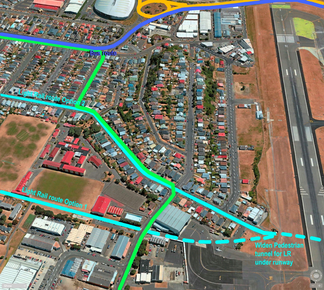
This first image carries on from the previous post where a tunnel bursts out of the hillside at Kilbirnie, and a PT route races across the flat paddocks on the way to the airport. In this scheme, the key idea was to get to the Airport as quickly as possible, through areas of population so that the general populace can benefit as much as possible. Hence Route option 1 here continues along the current walking track and heads straight for the existing tunnel under the airport runway. Route option 2 continues down Coutts Street, follows the slight kink, and also heads for the present tunnel, which would of course have to be widened considerably.
Meanwhile, the route down Rongotai Road, shown in dark blue, seems to be what LGWM and others are pushing for. That may seem to be the easier way, but personally, I think it is full of potential pitfalls. So too, of course, is tunnelling under an existing runway – that should be perfectly possible to do so without causing any subsidence in the landing strip above – but who wants to stick their neck out and say there is no chance of failure? The slightest slump in the ground above would mean that the airport would be closed and repairs could take months – so any fault would cause the end of the airport – and Wellington – as a going concern. It should all be perfectly possible, but the nagging reminder of the hole in the tunnelling operation at Heathrow in the mid 1990s, where the Heathrow Express tunnel inadvertently created a slump under a car parking building near the airport – and the slump only stopped when the whole building had been sucked into the morass. Solution: hundreds of tonnes of Quick-setting concrete were then poured into the hole. Not a good look for the British tunnelling industry, and difficult for the miners to continue digging through a mass of concrete…
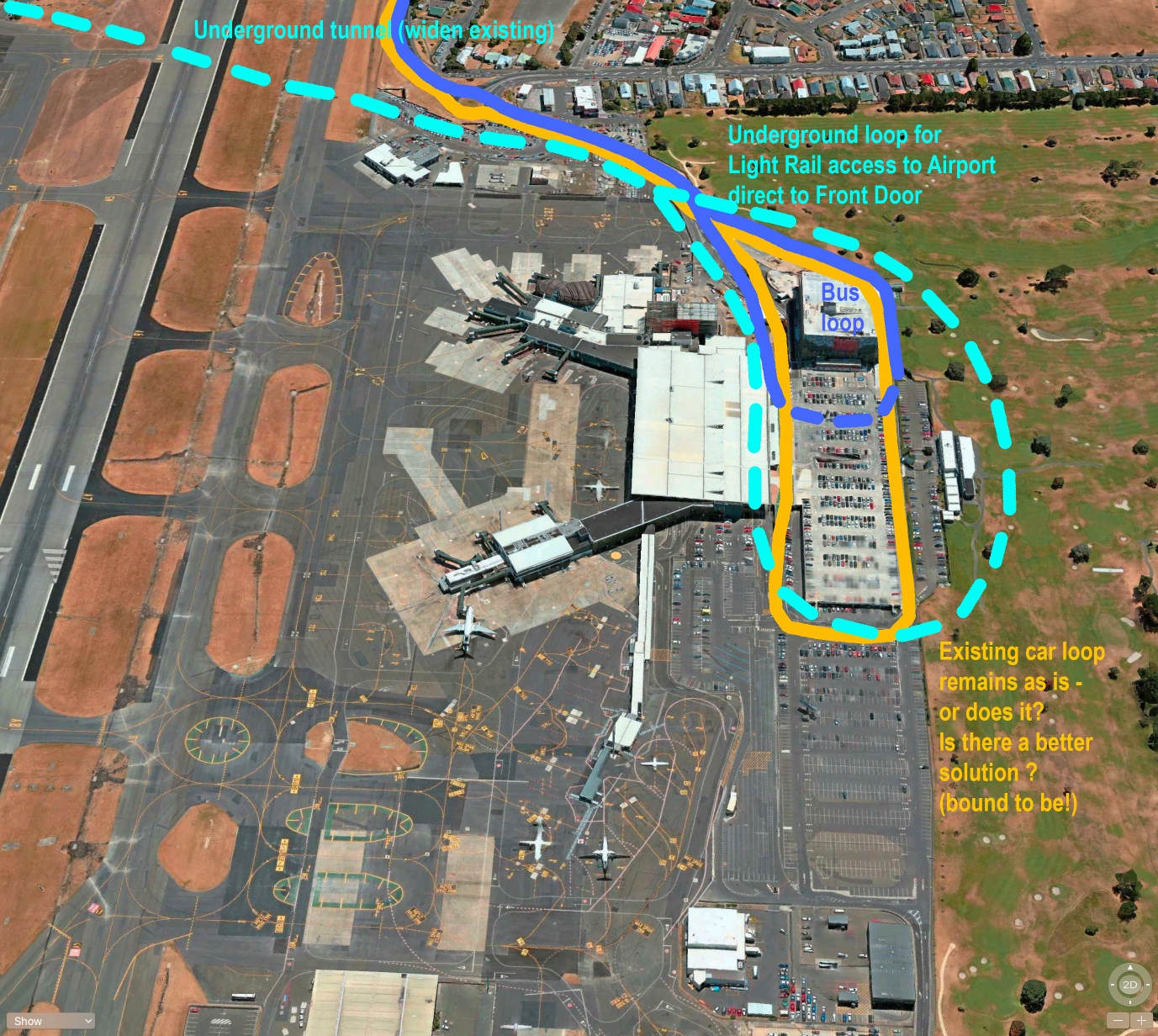
Anyway… let’s just assume that it would actually be possible to widen the existing tunnel under the airport, and that LR / PT was to follow that line of thought. The picture above shows you where the trains would come out: annoyingly, just north of the Air terminal. If this was the end of the line, then the train / tram / bendy bus / whatever would need to turn around. Of course, if it was doubled ended then the driver could get out, walk to the other end and drive of down the route they had just come in on, but that means a slow service. The faster approach is to build in a loop, and the perfect situation is as it is in Schipol Airport in the Netherlands, or Stansted Airport near London. Trains take you right to the edge of the air terminal. Honestly: that is soooooo good to travel that way. And so everyone takes the train and no-one takes a taxi. Life is much better that way.
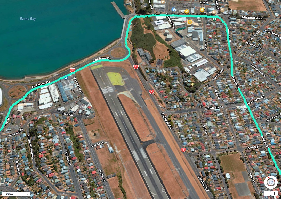
But of course, there is another way. This sketch above, also by the Fish, shows what I believe is the route being proposed by LGWM and seconded by Betterbee yesterday. I’ve a lot of respect for the person called Betterbee, who really does know what is being talked about, so hence why I am expanding this post.
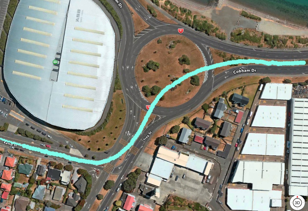
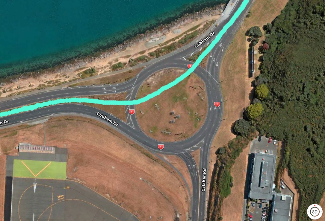
The line cruises down Rongotai Road, kinks up along Troy St, and hits the first Cobham Drive roundabout. It then follows Cobham Drive along the edge of the runway end (technically called the RESA or runway extension) and then somehow sneaks around the second Cobham Drive roundabout, before making a quick detour up to Miramar and then shooting down Hobart Street all the way back down to the Airport. In the drawing above, I’ve carefully kept to the side of the roundabouts, as the way I figure it, the last thing you want on a roundabout is a tram racing through the middle of it. However, that is exactly what is implied by the official LGWM pictures like this:
The PT system, whatever it is, is clearly going down the centre of Cobham Drive and so therefore must also be going through the centre of the roundabouts too. So I’ve drawn a line through those two too, to illustrate my point.
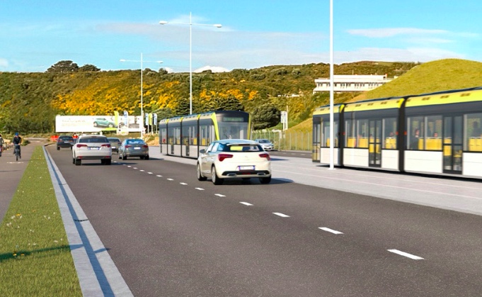
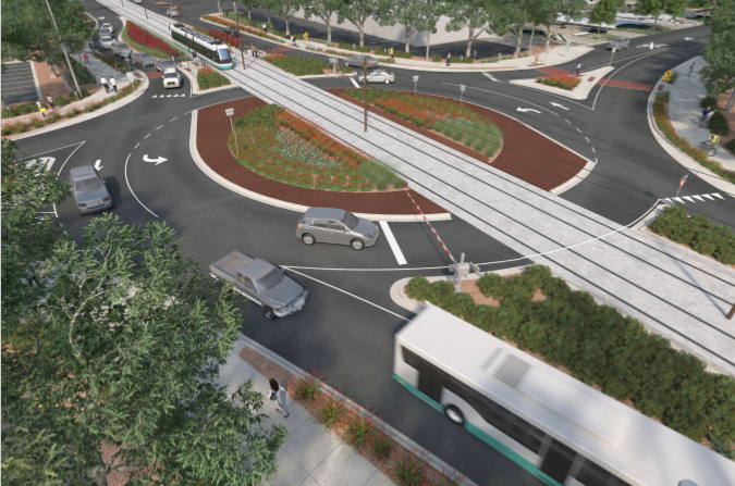
The route that LGWM are implying is something like this, above, as well as like this other one, below:
I don’t know about you, but in my mind, this is crazy talk. That’s a 70-80kph speed zone around these points and bringing a PT line across a busy intersection is asking for trouble. I wondered if it has been done before, ever, and to my surprise it has, although not in as high-traffic area as this.
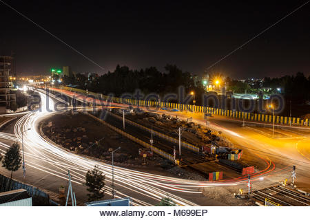
The image above was what was planned for somewhere in Toronto, while below is a snippet of what has obviously been built in Addis Ababa.
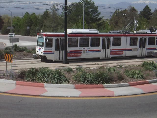
And here is one of a TRAX tram cutting through a roundabout in Utah near Salt Lake City, so yes, this obviously can be done.
So there we are. There are evidently several ways in which we could get to the airport in time using future public transport. I’m reluctant to recommend that these ground level interactions between PT and cars go ahead, especially at roundabouts and intersections. To me, there is really only one safe way for a tram to cross an intersection; and that is to completely separate the two, like this shot of the SkyTrain in Vancouver: Your thoughts?

have a flick through these, The first one addresses a whole pile of questions about the Runway tunnel (Page7),
Basically, you can’t cut and cover with the runway being used, leaving boring the only option, and given the nature of the whole area being 1950’s backfill they estimate you need to remain at least 20m below the surface of the Runway for the loads to be effectively dispersed.. ( and 20 metres down means quite long ramps at each end…
https://getwellymoving.co.nz/assets/Documents/Technical-Documents/25-June-2019/8-Preferred-mass-transit-route-response-to-further-queries-LGWM.pdf
https://getwellymoving.co.nz/assets/Documents/Technical-Documents/Mass-Transit/9-Wellington-Light-Rail-Public-transport-network-integration-concepts-presentation-MRCagney-1.pdf
https://getwellymoving.co.nz/assets/Documents/Technical-Documents/25-June-2019/12-Wellington-Light-Rail-Transport-Integration-Te-Aro-to-Newtown-MRCagney.pdf
You can look closer to home for this, albeit HR instead of LR.
https://www.google.com/maps/@-41.5132914,173.9599859,3a,75y,191.29h,72.68t/data=!3m6!1e1!3m4!1sJLlYZjFJwOqw6EBlZnnEuw!2e0!7i13312!8i6656
The Redwood/Main/Sinclair Streets and Park Terrace roundabout intersection in Blenheim. A pretty little mess of a thing.
Yes, that’s true – there is one in Napier (Ahuriri) that I am aware of as well. But I’d still say that all these examples are of rail routes which are infrequent, on car routes that are also infrequent. In the case of Wellington’s Cobham Drive, and the large and speedy traffic volumes along there, with an associated risk from a LR going each way at every 10-15 minutes, that potentially makes a crossing every 7.5 minutes, and potential carnage from cars trying to “just whip across before the train comes”.
We’ve seen how crap kiwi drivers are when it comes to safety at level crossings, even when there are bells, flashing lights and barrier arms. Bugger that for a game of soldiers if they have all that going off every 7.5 minutes all through the day and half the night. If it is to be done, it needs to be done properly and future proofed, so that the two highly different means of transport do not come together in the middle of a roundabout – the worst place possible.
Greenwelly – those links are FANTASTIC !! – and yes, they have all the required info and more besides. I thought I had a good look through LGWM’s technical documents, but didn’t find those ones. Very interesting. I’ll go away and have a look.
I know it’s a bit roundy-bouty and the turns may be a bit sharp but there’s an alternative going on to the south – what about down Onepu rd to Lyall Parade and then through the already constructed tunnel at the south end of the runway.
Less traffic – may need to have some sort of shared access through the tunnel but it’s not that busy anyway and approach the airport from the south where it’s a lot less built up and there’s room for a terminal etc.
Also gives better access for the good people of Kilbirnie, Lyall Bay and Rongotai.
Thanks Andrew – that is one of my favourite tunnels – I like the lighting and the patterns on the wall and the little chap waving at the end. But I do think that it would be a long route to take, and delays on the route to the airport are the travellers worst nightmare. Weather issues are one of the reasons why I was thinking about a route down the middle of the land at Rongotai – the northerly is more frequent and will drive salt onto all the electrics, but the southerly is worse as it will bring fine sand and icy temperatures, all of which are not good for LR – or for anything really. And that southerly route would be very southerly indeed…
If I remember, the subway under the airport is only about eight feet high.
I think it might be necessary to build a new one.
Henry – absolutely – of course it would be necessary to build a newer, substantially larger one. But it is way too short a distance to use a TBM (a pressure-balanced TBM could dig under an airport with no danger of collapse) and so they would have to dig it by hand. And the easiest way to dig something by hand is to use the existing route, and enlarge it.
Anyway – bygones. It sounds as they they want to go to the north.
Thanks to Greenwelly for for those links, and to Levi for the continuing useful posts (and for the kind words!).
Yes, Cobham Drive is a 70km/h speed zone, but there’s a question as to whether it ought to be – and the roundabouts are hardly a 70km/h speed environment. There are indeed plenty of examples of tramways going through the middle of roundabouts and across dual carriageways, so nothing new there.
As the (excellent) diagrams show, one thing that there’s no shortage of at the two Cobham Drive roundabouts is space: the roundabouts themselves are very large, plus lots of green space around them. Using that space sensibly means that some of the difficulties could be minimised, if not disappear.
For instance, if the line comes down the median strip of Rongotai Rd (grassed track, possible with light rail, would retain the current ambience), it could then swing over to the eastern side of Troy St in front of the fire station and head east to follow the southern side of Cobham Drive, avoiding the Troy St roundabout entirely. It could then either avoid the Calabar Rd roundabout by sticking to the south side and crossing Calabar Rd at its entrance to the eastern roundabout, then following the eastern side of Cobham Drive northwards to Miramar cutting; or cross Cobham Drive on the level (like this: https://commons.wikimedia.org/wiki/File:Tram_crossing_at_Gravel_Hill_-_geograph.org.uk_-_692969.jpg) and avoid the roundabout on its northern side, keeping to the western side of Cobham Drive northwards; or go straight through the middle.
All of these have their pros and cons, and there are additional issues like where the ASB Sports Stadium stop goes and how the line goes through Kilbirnie and Miramar town centres, but they do indicate that there is an achievable option out there.
And northerly winds will blow salt on to the electrics, but the trolleybuses coped with that for 50-odd years – and wireless light rail is becoming more and more common.
Just noticed that the ASB aerial shows the route coming down Kemp St. I think that unlikely – Rongotai Rd would be a much better option.
Great diagrams and fantastic dialogue here. Don’t fall in to the trap of assuming cars are the priority vehicle though, that’s how we got here in the first place. There’s no reason that cars couldn’t be made to wait for the PT in the shared roundabout, or for pedestrians / bikes / scooters / hoverboards. The primary objective of all of this LGWM project work should be removing the dependency on the car and the mindset that it is the best / easiest option.