
Having been looking in depth at the Airport route last week, and having already looked at the Basin area, its time now to return to Base One: the start of any Light Rail / Public Transport route at Wellington Railway Station. A lot of this has been covered off by LGWM in their document dump, which I have been pouring over for the last few days, but I still haven’t found any definitive plans in there. So, once again, I’m doing my own. Let’s see: where to start?

Everything is tied together in life, and especially in the design of a new traffic system for an entire already/existing city. We have a grand railway station where, currently, everyone gets off. Then they either walk, or get on a bus. A precious few ride off on bikes, some on electric scooters, but basically we have one giant mode change, from train to bus. And that’s a massive problem, as it involves an awkward, uncomfortable transfer, that takes time. If we want a transfer onto the new form of Rapid PT (whatever that may be) they need a better transfer method – ideally, get off at one platform and cross to the other side of the platform. London Underground, which I know best, has this on precious few stations (most transfers there require a long trek up and down stairs and narrow corridors).

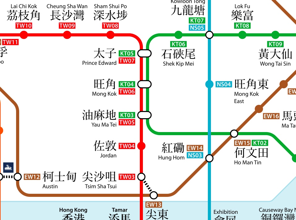
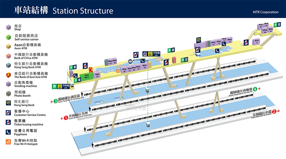
Hong Kong’s MTR is so much better – well designed for the millions of people that use it. At stations such as Mong Kok and Yau Ma Tei there are simple same-platform line changes, with one set up for north-bound changes and another set up for those headed south. It is so simple and beautiful it almost makes me cry. There was a genius in charge of designing this – Roland Paoletti – and it works seamlessly, day after day. Although we don’t have the millions of bodies that HK does, there is no reason not to try and design it right, right from day one.
Those people still whimpering on that any new PT service absolutely MUST go down Lambton Quay are missing out on the point that if you do insist on that, then the buses currently going down that route will have to go away first, and you are going to risk losing passengers for good. Those who have accepted that the fastest and cleanest way is to go down the harbourside Quays have got my vote. Two lanes of traffic can be closed off in an instant and work can begin to create the Rapid PT along that route. Whether you are pushing for Trackless Trams or Light Rail, either way you are going to have to dig up the ground, divert ALL the services underneath it, and reinstate a new ‘track’. Ironically, with TT you will probably have to do more work, as it will involve making a reinforced concrete base, whereas with LR the rails sit on sleepers bedded on compacted rock: probably easier. Plus, in theory you could, like many European cities, grow grass in between the tracks.
Or, you could have a TTS, meaning more concrete (not less). The advantage with TTS is that, of course, you could have buses mixing with the (trackless) trams, or as we prefer to call it: straight buses mixing with bendy buses.
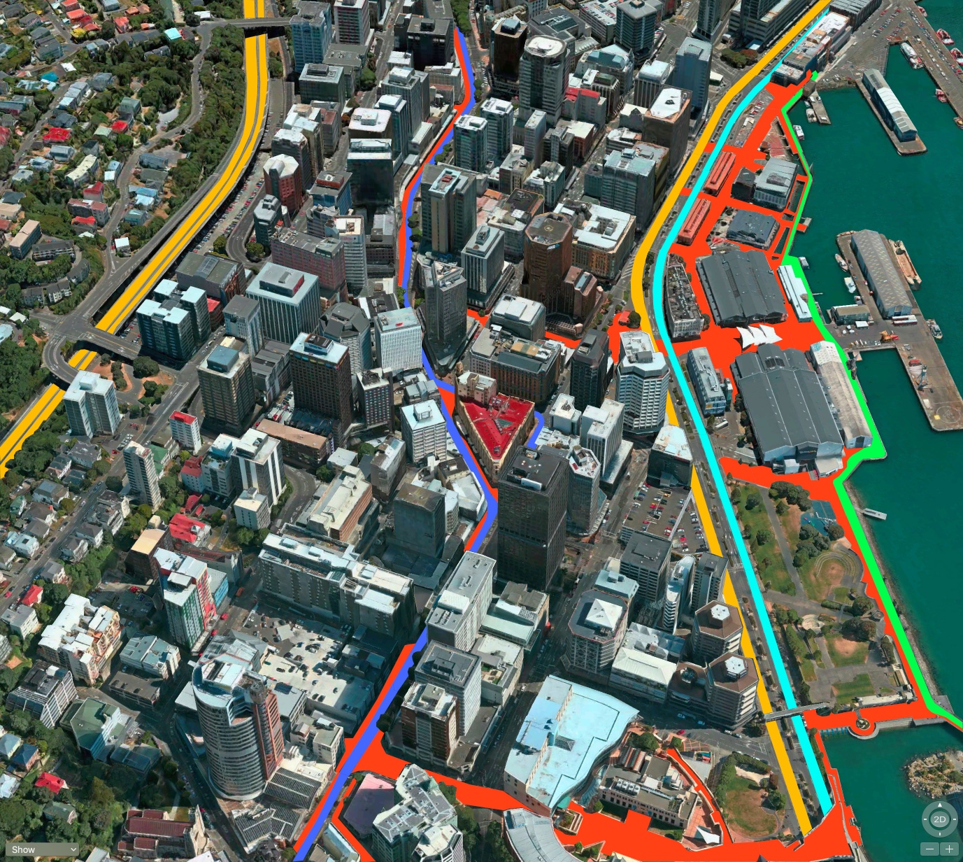
My pick would be to have both sets of tracks (i.e. north and south) to hug the east side of the present wide boulevard, which would avoid more altercations with vehicular traffic due to less crossing points. Essential if you want your Rapid Transit to actually be rapid. So: where to start?
As Julie Andrews sang all those years ago, “Start at the very beginning, it’s a very good place to start.” Ah yes Julie mon amour – but where is the very beginning? If you say Wellington Railway Station, I do believe that you are wrong. To get a good transfer, you probably need to change over earlier – build a new station on the way in to Wellington’s final big brick pile, where those wanting to go further can easily slip out, across a platform, and onto the new super-duper-extra-calorific system of PT. I’ve shown those on the plan that there is some means of cross-exchange north of the station, it could be above ground, it could be below ground, or it could somehow link up on the same platform.
But if you believe that the current Johnsonville Line could easily be converted over to Light Rail units instead of the Matangi (as shown on my pic above as a light blue line going north) then you also need to solve the problem that the actual units really need to be 50m further east…. …so I’ve shown a simple walking route connecting the two above the tracks, although a better, waterproofed link is really needed.
I’ve spent hours working on these pics – bored, nothing else to do at work – so I hope that you appreciate the time and energy that has gone into this: heaps! It wasn’t until I finished these that I found the treasure trove of LGWM documents, where some of these issues are tackled (but not this one – or at least, I haven’t found that one yet). But hey – don’t you like the bright orange/red swamp that indicates our mainly pedestrian areas? I haven’t gone down every footpath, because, you know, life is short, but you get the idea I hope.
The official vision for LR along the Quays has it slightly different, with one track of PT on either side, meaning of course that it will be far speedier going south than going north, due to the amount of intersections it would have to cope with. That’s the bit that slows down the current trip every day – and I don’t see how they can avoid that happening here too. My scheme, of course, is so much better for that – speedy PT / LR along the east side of the Quays, but that would also have the effect of being more of a barrier to pedestrians wanting to get to / from the Harbour. You win some, you lose some. What do you think is the right solution?

In lieu of commenting on anything PT-wise, can I just say Levi, your diagrams look stunning. I do not doubt you when you say you spent many an hour putting love into these – it shows.
Can I ask what program you’re using to get the base visuals? Not Google Earth, but something else…?
Thanks Seamonkey – it’s just Apple Maps and photoshop.Glad you like them.
If you want to get away from the mindset of “LR starts at the station”, another possibility could be to send it all the way down Aotea Qy to the ferry terminal and have a station transfer across platform 9. (Bus replacements and long-distance buses would have to go somewhere then, but they could move to the ferry terminal and that could become the ‘long-distance’ hub, especially given that KiwiRail is keen to redevelop it completely anyway.)
Yes, absolutely, that is the sort of thing that I was thinking of. Needs to happen, and yes, ferry terminal would be a good place. It would be nice if we knew where the Ferry terminal was actually going to be (still no guidance as to which of the 3-4 possible sites it may end up being on) but that is the sort of joined-up thinking that our region needs.
Some stream-of-consciousness thoughts on these thought-provoking ideas, diagrams and comments:
1. No detail on the LGWM website is definitive – it’s all just ideas (some more concrete than others) at this stage.
2. Cross-platform transfer is an excellent concept, but it’s not easy (and not cheap). For instance, at least one line will have to cross over another, and for any form of rail transport that takes an awful lot of space (Hong Kong does it underground); and I’m not sure how the current four railway tracks going into nine platforms would mesh with probably two tracks using two platforms. How to choose which platforms interchange with which?
3. Roland Paoletti was the architect that designed HK’s stations, but it’s getting the tracks in the correct relative positions that’s the difficult bit. Once you’ve done that, the stations are (relatively!) simple.
4. The key point about rapid transit that often gets overlooked is that it’s the overall speed of the passengers (not just the vehicles) that is important. Putting the mass transit on the eastern side of the quays will mean passengers will have to walk further – the sea doesn’t generate too much demand – so that part of their journey will be slower and less convenient (and as a result they may well use the car instead).
5. It’s not that a new PT service must go down Lambton Quay, it’s that not going down there misses much of the pedestrian catchment (see previous comment). Also, LGWM says we must have two PT spines, so if we haven’t got the new service on the Golden Mile we continue to have the old service, buses, there. Is that what we really want? (And international experience shows that pedestrians mix much better with trams than they do with buses.) So start by putting plain ordinary bus lanes along the quays, and continue to use them for the secondary spine when the Golden Mile becomes a proper transit mall.
6. The ferry terminal idea overlooks the fact that the ferries are primarily for vehicles (road and rail), which common sense and LGWM say that we should be keeping out of the city, whereas passengers on buses and trains generally want to be in the city (and that’s where we want them, because that’s where they spend money). Moving city-centre PT termini to out-of-town locations is generally a recipe for an unpleasant and inconvenient disaster.
So, despite all the (very) pretty pictures, I’d go for what is practically standard practice in continental Europe, a PT terminal right in front of the main entrance to the station with mass transit serving the centre of the city rather than skirting the edge. Simple (relatively!), convenient and intuitive – what more do we want?
Betterbee – really good commentary on these proposals, thanks for that. Some of it I agree with, some I’m not on the same page with you, but it is all good reasoned, well-argued points. There are many things I could say, but just for now, I’d still prefer to see the forecourt of the Railway Station kept for pedestrians only – the cars and taxis can and do sweep past, but having a LR tram sitting in the forecourt, even just for a few minutes while it loaded and unloaded, would still be a pain in the arse for any rail user. It needs to be out of the way, not just there, but also out of the way of the streams of cars passing by too. And to me, that means that something needs to go underground or higher up above ground – but not at ground level. We would need Grade Separation. So my big question is – how are we gonna manage that?
My preferance would be for a LRT starting from adjacent P9, lets call it p10, along the median lanes of the quays to Chaffers St, pilfer a spot of new worlds carparks if need be and allen st to Courtenay Place. The buses & staff carparks would have to go somewhere else. Or the LRT could start from outside bluebridge linked to the station platforms via a subway?
I can’t see what the fuss is about getting commuters across a few lanes of Quay traffic. Even a penguin can do it.
When you put it like that…. yes, not so much of a problem.
Actually, I’m glad that someone did actually see them crossing the road, or else I would have presumed alternative routes for the wee things. Like: the Kumutoto Stream empties out in the middle of the waterfront precinct – and so it is technically possible, with the right tide, to swim right up to Lambton Quay at Woodward St (if you’re a penguin – not so convenient for humans). There is probably also a similar underground culvert near the Railway Station, given that the Thistle Inn would have been set up near a source of freshwater stream….