
Following on from the diagram that Eye of the Fish published a short while ago, it has come out that this is, indeed, more or less exactly the route that LGWM have proposed as well. The binding issue is, of course, that they have still not done three things:
A) Agreed on what type of high quality PT we are going to have; and
B) Agreed that SH1 needs to go underground along the route of Karo Drive; and
C) Agreed who / what / how / when someone pays for it.
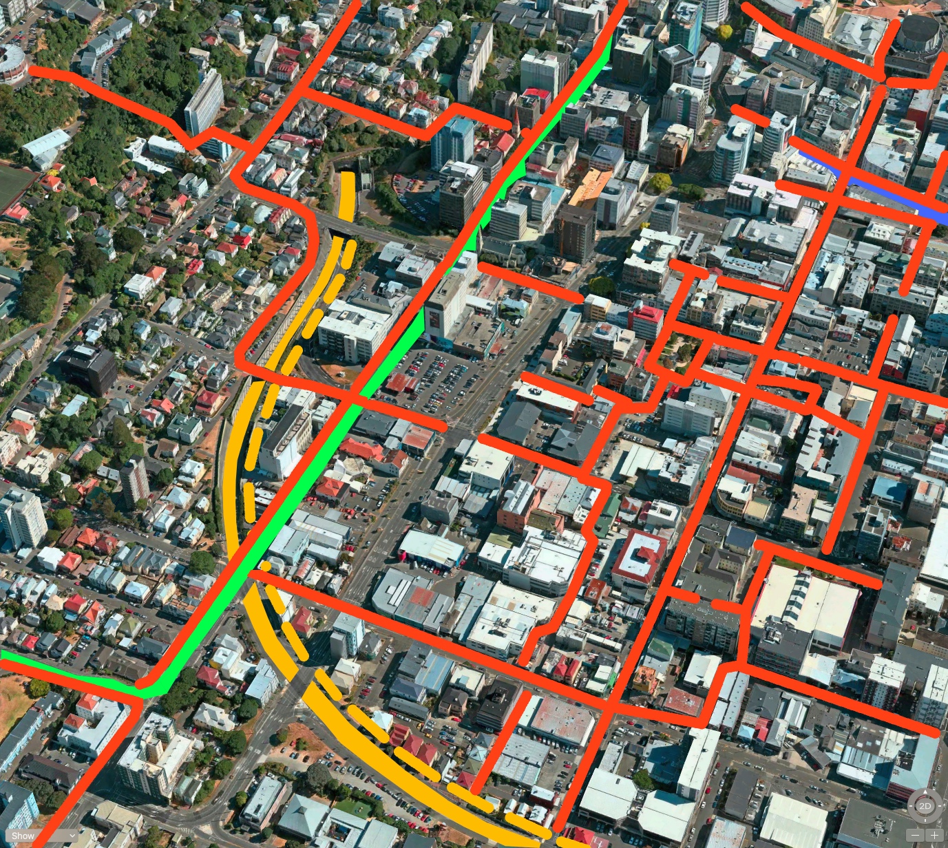
A), I fear, may go on for some time yet, but in the overall scheme of things is less important right now. Whether it is a tram or a bus or a train or something in between right now, none of that matters so much as the route it is going to take. There was some confusion when the LGWM sample pix came out – was it showing a train up Taranaki St, or was it showing a high-speed bus heading to the Basin? In a way, both of those were right – and so was the Fish. I’ve tweaked my original Basin diagram a little, so it now looks like this:
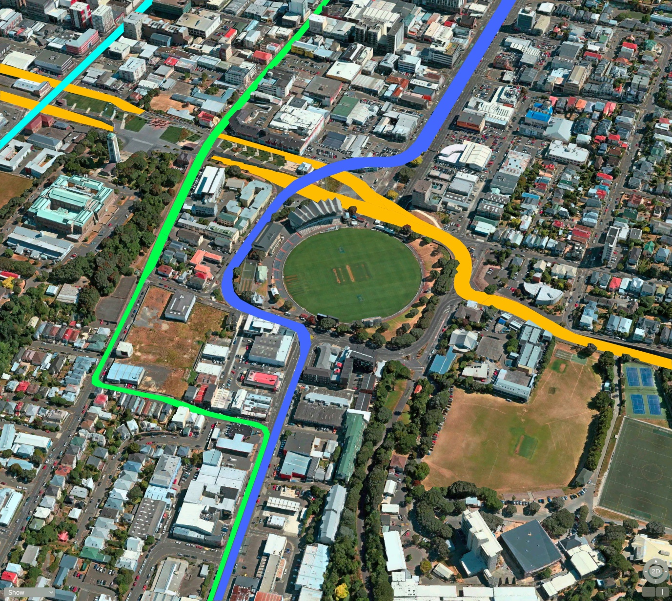
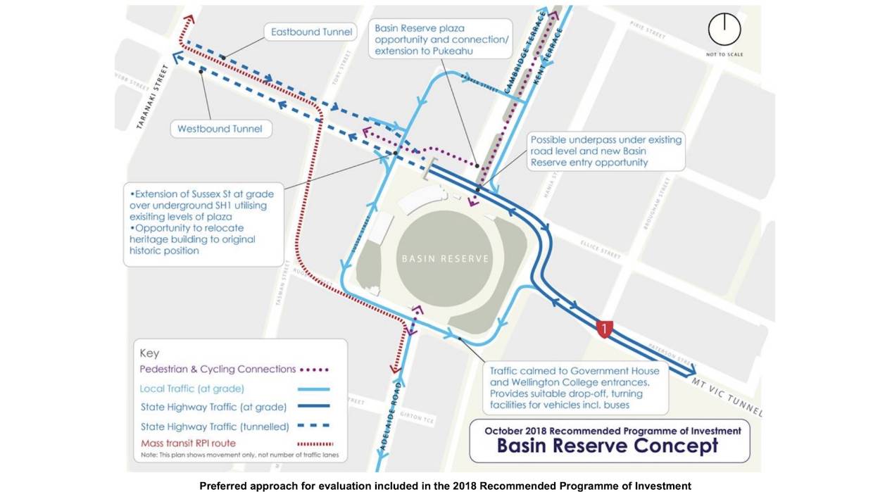
The green line is where I reckon a bicycle super-highway could run, and that varies a little from LGWM who instead use that route (nearly) for the PT spine. And that looks rather similar to the official diagrams released by LGWM, of which there are two versions viewable on the LGWM website. Just below here is the LGWM “preferred approach”, looking suitably diagrammatic and awkward, but at least setting down what might actually happen here. The red dashed line indicates the route of a “Mass Transit RPI route” which I presume means either Light Rail (LR) or Trackless Tram System (TTS). Quite how RPI means LR or TTS I am not sure, but perhaps it stands for Rapid Public Iguana? Ignominy? Insurance? Initiative! So I’m just calling it PT for now.
And then there is this, the “Figure 13” diagram of the Basin. That looks a whole lot more figured out, with a bus-turning loop outside the School drop off zone, Sussex St taking an extension over the top of the SH1, which is now at ground level and no longer on a flyover. Mission accomplished.
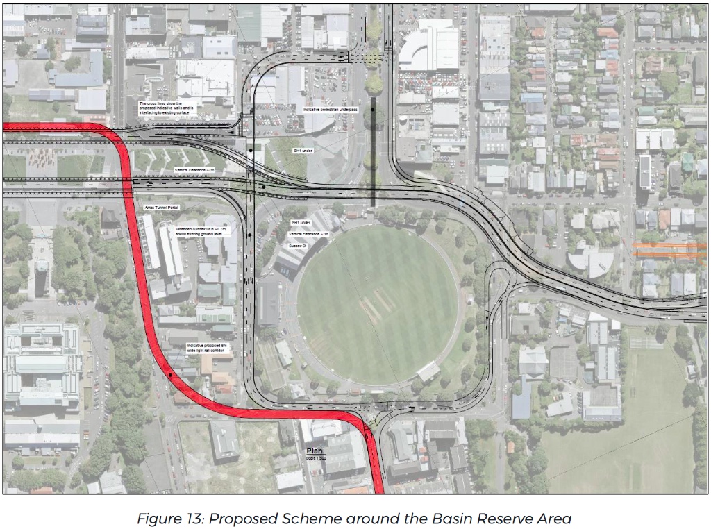
The answer to B) is that The State Highway is now shown in a trench all the way from just before the House of Compassion (you know, the little brick house of Mother Aubert that no-one knows what to do with) and right the way through to the other side of Taranaki St. In return, the vibrant red line is the new PT line, unexpectedly snaking its way alongside the SH1 and then diverting off down Tasman St to avoid the Basin.
That’s one way to do it, for sure. There are a couple of interesting things about this picture (Figure 13, above). One of these is that the SH1 is now shown in two separate lines, with one existing west-bound line running through the Arras tunnel (presumably now extended at both ends), and a new proposed east-bound line running just where I thought it would: in the clear path one the other side of the fence from Pukeahu Park. That’s where C) comes into play, as the Councils, the Treasury, and the Government can’t agree on who would pay for that. Of course, if they had done it all in one go when they built the Arras Tunnel it would have been half the price it will cost now, but hey, hindsight is cheap. What is carefully not shown, however, is exactly what happens at Taranaki St.
It is also fairly similar to what the Architectural Centre was banging on about with their Option X – not quite the same, but close enough. Bravo.
So – what happens past those borders then eh? Well, I’ve had a chance to think and to play with some more aerial pictures, and I reckon that to the south, down towards Adelaide Road, it might look like this:
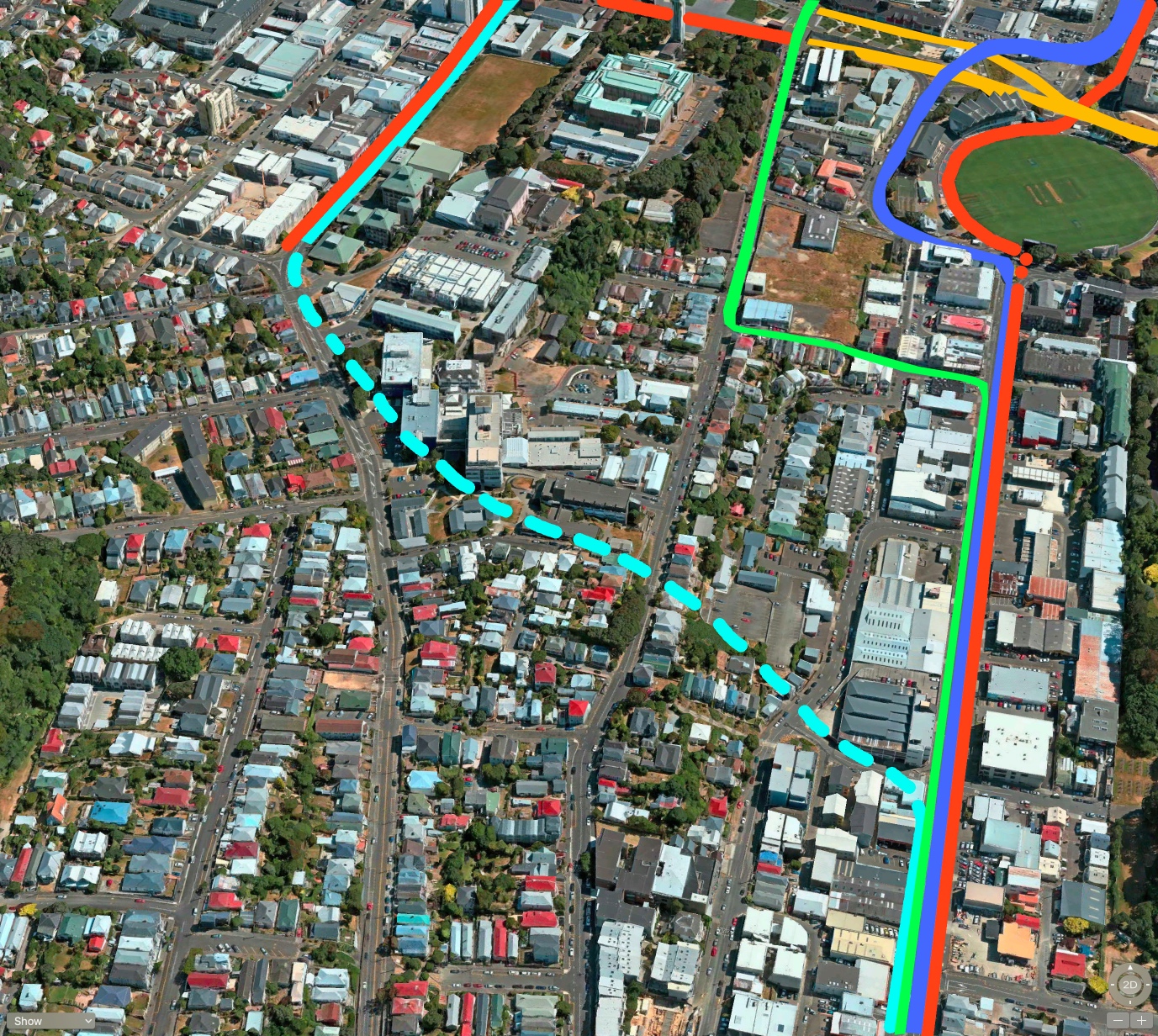
You can see here the issue of taking the PT route all the way up Taranaki Street – at some stage it needs to cross over to Adelaide Road and that can either be done at ground level as LGWM have done in Figure 13 above, or a possible tunnel under Mt Cook as shown here with a dashed pale blue line. It’s not a long tunnel, nor a particularly difficult one, but still: PT goes well in a tunnel. And… they’re expensive.
And then again there is the scheme at the other side to Taranaki St – i.e. what happens at the site of the present “trench”. One line I’ve shown dashed, to indicate a possible tunnel (probably cut and cover to be honest), but I’ve also tweaked the current scheme at the junction of Karo Drive where the present Victoria St clashes with Karo. SH1 should go underground here, with Willis and Victoria and Taranaki all going over the top. I’ve show lots of the rusty orange colour, which indicates pedestrian-friendly streets – lots of them – because we need to get a whole lot more cars off the roads. Streets are for people!
In the next day or so, I’m taking a look to the east.

Thanks for this very helpful analysis! Two points:
1) RPI means “Recommended Programme of Investment”. Given Florida’s problems with invasive iguanas, I’m not sure iguana-based public transport merits further detailed consideration, though it would certainly gain widespread media attention.
2) The “October 2018 RPI” Basin diagram dates from when Karo Drive undergrounding was part of the package proposed to be funded. It is no longer in the funded part of the overall package. Therefore, questions remain about what would happen on the Taranaki Street side of the Basin – has LGWM developed an updated version of this plan without Karo Drive undergrounding, and if so, when will it be released?
Tim Jones – hello, and thanks for your comments. Helpful to have that RPI acronym cleared up. I was way off, wasn’t I?
Its interesting to think about what needs to change from this Oct 2018 diagram (with a two-way underpass) to what will be officially funded now (i.e. both directions staying put on their current routes). I’m presuming that SH1 will continue going down Vivian St for the present – although long term it is a death-trap, given the increasing amount of pedestrians walking up and down Cuba St. Somebody WILL get killed there – there are close calls there everyday. Car and Truck drivers have just come off the motorway and still have a 100kph feeling trapped in their head – so slowing down to 50kph is a big problem and giving way to pedestrians is the last thin in their mind.
But the other side of that, is that this scheme (figure 13) can be implemented with the Sussex St bridge over SH1 being built so that the “underground east-bound” lanes of SH1 can follow on later. It’s not hard. So there is, in my mind, absolutely nothing to stop them starting work on these works straight away. Not that that will necessarily help speed up the traffic at all – the Basin Bridge Board of Enquiry conclusively showed that work to the Basin itself would have little effect on traffic delays (30 seconds only) unless the obstructions at either end were cleared up on the west side (traffic lights at Taranaki, Cuba, Victoria and Willis) and the east side (twin tunnels under Mt Vic and widening of the route all the way through Hataitai.
So then we are left with the thing that we should all be concentrating on: the PT as shown on this RPI. Is the PT a LR or a TTS? FFS, does it even matter at this stage? Is it the right route to go snaking along the back of Pukeahu Park? I’m presuming it is not underground, as it will need to cross over the SH1 twice, so it must be at grade. What do you think of the route? I’m quite dubious!
Great pictures! Great questions. I wonder if there are any geotechnical wierdnesses in Mt Cook that would make a tunnel there off the table? (e.g. the underground stream that runs through Puke Ahu, (re)discovered when they did the drilling)
I would very much like to see an engineer comment on the practicality of running rapid transit underground through this area. It looks on the face of it that the 4 right-angle turns, plus running through a pedestrian area, would make the proposed above ground route the slowest section of what is supposed to be a “rapid transit” project.
My understanding is LGWM now envisages that SH1 will cross Taranaki St at grade in both directions, even after the eastbound traffic is relocated away from Vivian St to run next to the westbound traffic. This would mean an underground rapid transit route would have to start north of the future eastbound SH1 on Taranaki St and emerge south of the Basin on Adelaide Road.
Over the life of the system, the extra cost of running rapid transit underground would likely be paid back several times over from the time savings and increased safety. Why risk spoiling the ship for a halfpennyworth of tar?
Thanks Isabella, and yes, there are concerns from the geotechs about the underground streams round here. One is the century-old “brick culvert” running down Tory St – the team on the Pukeahu project were very concerned not to touch this as it still holds water (those old-timers dug it, 4-5m below the surface, using picks and shovels. Bloody hard workers in those days). The other thing is that the Te Aro stream is still here, and I believe Taranaki St is a slight gully at this point, so probably exactly where Taranaki crosses SH1, they will find a watery stream…
Hello John Rankin and yes, I too was also surprised that they are proposing LR or TTS to take that route. There are some very sharp bends indicated there – first one at intersection with Taranaki St (not shown in Fig 13 above) and the other one at the corner of Adelaide – that’s why FIT’s route taking an underground route further south on Taranaki makes a lot of sense. But would cost more money. Have you noticed the dashed pale blue line on my second to last illustration? Is that a better route for a LR tunnel?
The way we would underground the rapid transit line depends on how LGWM decides to treat SH1 where it crosses Taranaki St. Because SH1 carries so much traffic, rapid transit must be grade-separated from it. This implies 2 options:
1. If SH1 goes under Taranaki St, rapid transit can run at-grade on Taranaki St, to the dashed pale blue line in the penultimate illustration.
2. If SH1 crosses Taranaki St at grade, rapid transit would have to go under it and continue underground to join up with the dashed blue line.
The options would cost about the same: either we pay to extend SH1 underground or we pay to extend rapid transit underground. From an urban form and amenity point of view, putting SH1 underground in Te Aro wins hands down, so in my view option 1 is better.
The thing I was most disappointed about with the whole LGWM announcement, apart from how long it’s taking, was that SH1 was not getting undergrounded through Te Aro. Having spent a lot of time up this end of town in the last year, it’s clear to me how intolerable having the two roads slicing their way through the city is; it has stunted development across a huge tract of potentially prime land and makes walking through this part of the city difficult and unpleasant. I’m still holding out hope that a future government will fund undergrounding and a second terrace tunnel, both of which will remove a vast amount of traffic from the quays and Te Aro.
I’m not convinced a second terrace tunnel would do anything other than than induce more traffic.
Tom, Mason, thanks for your comments. Regarding the prospect of a “second Terrace tunnel”, there was one clear piece of information that came out of the Basin Bridge Enquiry. The Commissioners spoke to someone who was one of the original designers of the “Foothills motorway” and he designed the Terrace Tunnel. He said it was deliberately designed with only one lane coming into the city, and two lanes going out of the city, because as he said: “to have two lanes coming into the city would only cause gridlock”. I respect his understanding – much as it must be annoying for motorists coming into the city each morning, to be in an inward-bound traffic jam, the alternative is worse. One lane coming in allows some of the traffic to disperse, drive through, park in side streets and car parking buildings. Two lanes coming in would just mean that the city chokes to death. Carmageddon. Gridlock. Total SNAFU. I’m with him on that one.
Levi, your comment about the deliberate bottleneck at The Terrace tunnel is very relevant. The same principle was applied in Auckland, where the Southern Motorway northbound reduces from three lanes to two at Mt Wellington Highway, by the Tip Top factory.
Without that bottleneck the Central Motorway Junction would be even more clogged than it is (hard to imagine!) creating a much worse unplanned bottleneck than the planned one further south.
The zigzag through Pukeahu does look suboptimal, and there’s another factor to be taken into consideration. It’s important to serve the various schools round the Basin (or rather it would be very silly to miss them when they’re so close to the route), so one of LGWM’s plans a stop is shown on on Adelaide Rd just south of the Basin. That’s achievable with the zigzag: would it be achievable with a tunnel?
Thanks Betterbee – that’s a good point about the School pickup needed near the Basin – especially as much of the current traffic woes are primarily caused by mums in SUVs dropping kids off or picking them up. The great thing about the scheme shown in Figure 13 is that the SH1 route is separated away from the school-run traffic – which should help things considerably on its own – but also, as you say, having a tram stop / bus stop right there has got the possibility of proving to be a very good thing.
With a Mt Cook tunnel option, the light rail station at the Basin would be about 150m south of the one in LGWM’s proposal (depending on the tunnel alignment). This would add less than 2 minutes to the walk from the station to the schools. It would reduce the walk from the station to Massey University by the same amount.
Thanks John. I agree: a Mount Cook tunnel option certainly has some key advantages over a land-crossing around / through this area.
LGWM answers questions about its preferred mass transit route, including its thinking around the Basin, in this document.
They appear to consider that “rapid” only matters for light rail: “The extent to which vehicle speeds are affected by corners along the route will need to be examined at the next stage. This will be particularly important under an LRT scenario, to achieve the high operating speed necessary to ensure it is viable.” So are we to conclude that trackless trams don’t need to be fast?
Yes, I found that document too – there are many interesting little observations in there. Like this one:
“The RPI takes a network approach that involves reallocating general traffic capacity from the quays route to the SH1 route via the duplicated Terrace Tunnel.”
So, the RPI therefore does plan to build a second Terrace Tunnel – a foolish move in my opinion, unless it is the thing that is done absolutely LAST. As I noted in the comments above, a second Terrace Tunnel would just lead to total gridlock, unless of course there was already a “two lanes all the ways to the planes” (and two other lanes away) approach.
Trackless Trams are just a pathetic silly diversion, not really one or the other, and certainly not really worthy of considered attention: unfortunately, our Mayor appears to have been attracted to the shiny new glittery subject.