Just what is happening with the roads and tunnels in Wellington? Does ANYONE know?
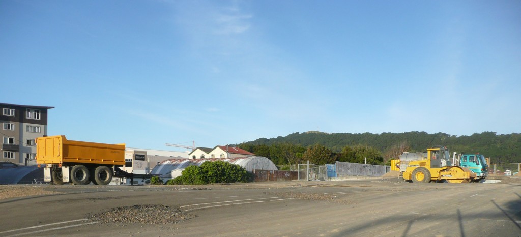
As we referred to in our previous post, there’s a whole lot of roading issues going on – not just down in Christchurch, but up here in Wellington as well. We’re all aware of the swathe of land that one day is meant to be a Memorial Park, with State Highway 1 winding through it – and despite it meant to have been started years ago, when Helen Clark still ruled the waves, there has been no progress – until now. No official notification. Nothing, apparently, is going on.
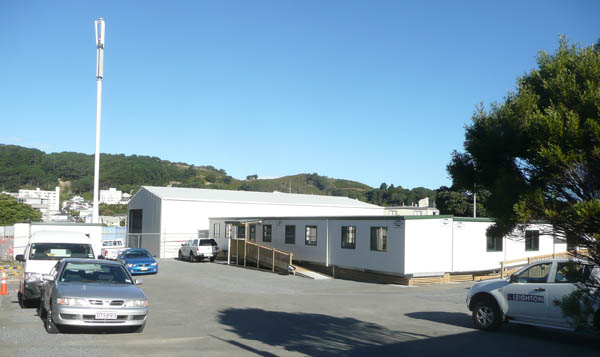
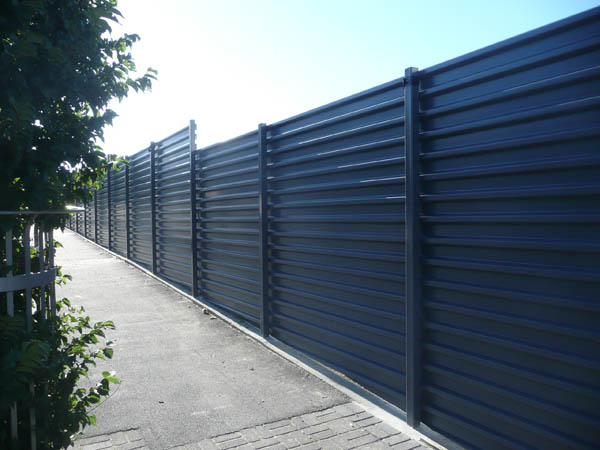
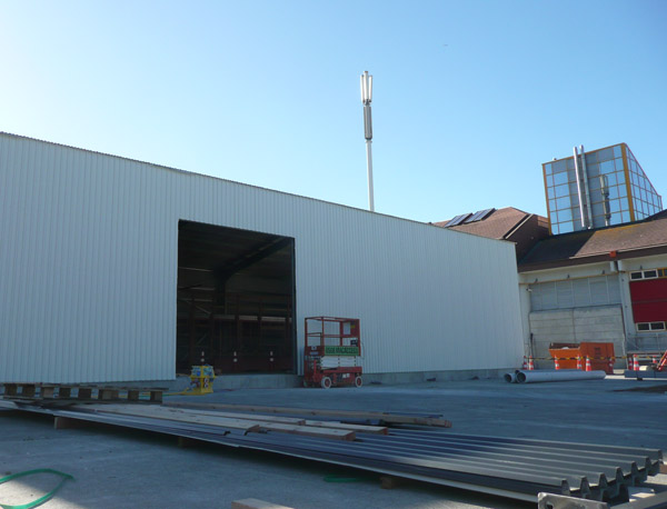
Yet, over the past few weeks/months, large concrete barriers have been stored there for use in the Terrace Tunnel refit, large earth-moving equipment from Goodmans in Waikanae have moved onto the site, and now a high security fence and a very big shed have been built on the site. Yet still, no comment.
Let’s recap.
Way back in the birth of time, before the internet (ie some time in the 1960s), the motorway was going to swoop through the Te Aro flat and end up joining into the Mt Victoria tunnel. People talk. Route not agreed. Money runs out. Nothing happens.
1990s: the path of the inner city bypass was still being debated; eventual route confirmed about 2001.
2002-5?: Something happens: the Inner City Bypass gets built. The phrase “Bypass My Ass” becomes rather popular. The actual bypass, becomes rather less so.
2005: Ministry of Culture buys land for a Memorial Park to be constructed next to the National War Memorial in Buckle St.
2006: Businesses along the Buckle St road slowly closed down. They’re really not happening…
2007: Architectural Centre runs competition for proposals for a memorial park in Buckle St.
2007: A design competition was run by the Ministry of Culture for the Memorial Park. No winner was ever announced, but somehow word got out that Athfield / Wraight had won the project. In the (paraphrased) words of Chris Knox / Del Amitri / and the Clean: Nothing Ever Happens.
2007: (April) – Over $10million in funding announced for possible park. Possibility of underground routing of the road is discounted.
2007: Bureaucrats discovered small children at Mt Cook school next to the Park, and the possibility was raised that these munchkins might be accidentally poisoned to death by noxious car fumes. Nothing continues to happen. Buildings continue to be demolished along the route, including the removal of a petrol station directly in front of the Memorial, and the demolition of a large HireQuip shed on a concrete pad next to the Basin Reserve.
2008: Transit changes into NZTA. Other than that, nothing happens.
2008: Design Workshop at NZTA serves up 5 options for possible Basin Reserve traffic resolution, leaked to the press, but never officially made public.
2008: Mayor Kerry P was still keen to link up the Memorial Parkway to the boulevarding of Taranaki St. Still nothing happening.
2009: (August) – Civic Trust holds a weekend of discussion called “Round the Basin“. Good ideas aired, but no one listens. Nothing happens.
2009: The Park went into limbo, the Labour Government went out of business, and the Nats got in. Well, that’s actually quite a lot happening!
2009: NZTA invited tenders to carry out investigations for Basin Reserve improvements. The contract was awarded to Opus International Consultants. Sorry to say it again, but: nothing happens.
2010: (March) – NZTA Wellington Regional Director Deborah Hume says the need to integrate the Basin Reserve improvements with the Buckle Street upgrade means it would be premature to finalise options for consultation before plans for the memorial park are confirmed, but confirms that: “Public input will be an important factor in the NZTA Board’s decision-making process on the transport improvements around the Basin, and we need to ensure that those making submissions have as much information as possible.†Nothing happens.
2010: (August) – Tunnels Alliance born, being an amalgamation of NZTA, SKM, AECOM, and Leighton. Projects include refurbing existing tunnels, and possibly building new ones.
2010: (October) – Park still in limbo, Kerry P got the Axe and Celia WB got in on an anti-roading campaign. Ministry for Culture publishes Wraight Athfield Interim Park plan. No one notices.
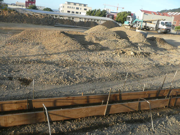
2011: (February) – Despite nothing ever being discussed in public, contract is let to Goodmans earthmoving contractors to install drainage, remove tarmac, resculpt land, and presumably create a park.
2011: (February) – Something happens: Large steel shed built on existing concrete slab – on site of former large HireQuip shed between Basin Reserve and War Memorial Park. Doesn’t seem to have had to go through any resource consent process: we presume it is only “temporary”. Nothing ever happens is said.
2011: (March) – Mayor Wade-Brown allegedly agrees to go ahead with roads in Ngauranga to Airport report. That includes twin tracking tunnels in the Terrace, Mt Victoria, double laning of Ruahine St, and other measures. That seems… odd. Given her previous stance.
Clearly, something has happened…
Post-script addendum:
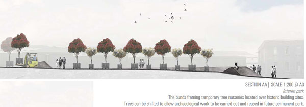
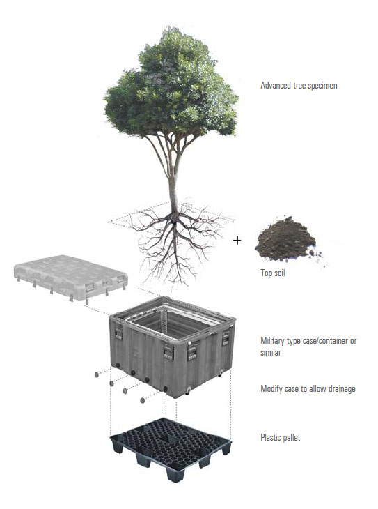
The MCH website contains proposals for an Interim Park plan, which it is now obvious that the contractors are working to. Excerpt from Wraight Associates plan included here, along with some pics from their submission. Apologies that I had not picked this up earlier:

The intention of the interim park design is to start the implementation of the New Zealand Memorial Park in a manner that commences repair to the existing site, while introducing and celebrating some of the ideas and components of the future park. At the same time it will enable the space to be used as the beginning of an enlarged memorial space. The proposal is to build some areas and elements that can be retained in the long term, and implement others that are clearly transitional in nature but
that are nonetheless contributing to the narratives and functions of the parks interim use.The central portion of the park is proposed to be established in its final ground form outcome, setting in place the major central ceremonial space of the park, comprising two lawns flanking a central limechip paved plaza opposite the existing National War Memorial space.
The western part of the interim park is proposed to be developed by locating clusters of trees in planters set out in the existing areas of gravel that denote the footprints of previous buildings. These areas would be further defined by minor ground works- effectively reinforcing the existing terraces on this side of the park. In this area it is proposed to undertake no excavation
for the interim park, but instead build up bunding to contain areas where temporary tree nurseries can be laid out. These trees will be used in the final park construction with the benefit in having them hardened off to site conditions.
The existing asphalt will remain largely as it is forming an undulating hard surface between the tree clusters- that will become the canvas for surface paint work- marking the layers of built history of the site. This will allow archaeological investigations to be carried out over the term that the interim park is in place thus preparing the site for final construction. The area of archaeological importance is confined to the western end from the proposed interim west lawn edge to Taranaki Street.The proposed interim design can then reveal the archaeological investigation process to the public as the work is carried out. This is achieved through the initial mapping of the historic built elements in paint across the existing asphalt and grouping the tree groves on the gravel surfaces of previous buildings. The tree groves can be moved about to frame areas under investigation over the period of the interim design. The interim design is intended to be in place for a period of one to three years. The central area can be used for ceremonial purposes throughout that time.

Not quite related, but I felt I needed to share. I just read this-
the city of portland oregon (you know the one that is heralded as an example of great urban planning??)
Has built their bike infrastructure for the cost of 1 mile of motorway.
http://www.politifact.com/oregon/statements/2011/mar/19/sam-adams/portland-mayor-sam-adams-says-portlands-spent-its-/
Why are we having to fight as if it’s a 50/50 split? 1 freaking mile of motorway could fund an extensive bike system.
I’m so sick and tired of the single minded transportation focus.
and for anyone curious just what that portland bike system looks like
http://www.portlandonline.com/transportation/index.cfm?c=39402&a=322407
Not only can you take light rail to the airport… but you can ride your bike there.
HELLO CELIA?!
I see what you did there with your post title.
Saw them play at Homegrown down on the waterfront and apart from the drummer having a tiz they weren’t bad for old dudes
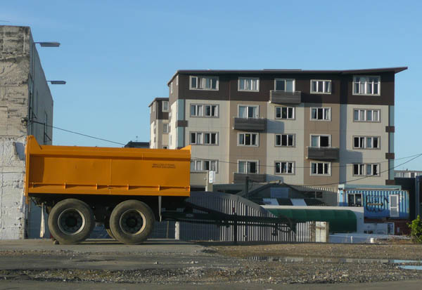
The main image of this post sort of looks like a scene out of a Polish film. What also struck me was how ugly that apartment block in the background is.
Sav – can’t be Polish – no donkey drawn carts or vodka. But otherwise, yes, agree entirely. Am hoping this draws NZTA out from under the bush they are hiding under.
It’s time this town actually had some dialog on this topic.
Not entirely sure what the diggers are doing on site, but given that the area is rich in archaeology then you have to hope that they are going to carefully peel back the asphalt and then dig for buried treasure. In theory there should be remains of naval dwellings, army barracks, and apparently even an old cannon or two. Then once they’ve dug all that up, they can plant all the grass they like.
Minimus, I’m with you on that one, for sure. I’m doing a whole lot of presuming here, but surely Celia must be doing a whole pile of work on implementing bike ways through Welllington? No sign in public of that yet, but really am assuming that will be proceeding fast behind the scenes. Not much point having a green mayor if she doesn’t do that at least!
your google foo is weak, a search on google news brings up this….
http://www.stuff.co.nz/dominion-post/news/4750456/Buckle-St-park-work-begins
Thank you James, my ‘google foo’ must indeed be weak. The force is not with me today, even Jedi though i be.
So: it is to be a park, and a tree nursery, even though final designs of the park plans and Basin plans have not been done.
Which leads me to believe that NZTA et al are even more lax at communication than I had thought. There is still No announcement on NZTA website, No announcement on Goodmans website, and No announcement on the MiniCult’s website…
[…] letter to the New Zealand Transport Agency about Wellington roads. In the words of the observant Maximus on […]
In some good news, NZTA have been in touch with us here at the Fish – thank you – a spokesperson for Mark Owen, the Acting Highway and Network Operations Manager, noted that:
“I see that in Sunday’s story you have commented on the area of Buckle /Tory St that has been surrounded by a large blue metal fence. That area is being used by Wellington Tunnels Alliance as a work site for upgrading the Terrace Tunnel. Resource consent was obtained from Wellington City Council and as part of that consent the NZTA was advised to contact people living in the vicinity to tell them about the worksite. That was done.”
“In respect of the Basin Reserve and NZ Memorial Park, the NZTA continues to work closely with the Ministry for Culture and Heritage, Wellington City Council and Greater Wellington Regional Council on plans for State Highway 1 through Wellington City. This work is on-going but the NZTA expects to be in a position to release more information later in 2011….. Matters related to the park should be referred to Ministry of Culture and Heritage.”
I’m actually reasonably happy with that as a reply from a government agency – shows that there is a rough time-frame that they are working to, that they apparently have been telling some of the locals what is happening, and now that we’ve got the correct info from the MiniCult up there, at least the community now knows a bit more on what is happening.
Hopefully later in 2011 the much-awaited “consultation” period will begin. To me, the consultation is a really important phase – the need to offer real input into really well thought out options – rather than just being presented with a fait accompli and being asked to tick box A or box B. The debacle at Kapiti, with 20 years of uncertainty and waiting to be completed with a completely new route, which then had new sub-options = shameful cock-up all round. Let’s hope we can avoid that.
On another note, the earthworking that Goodmans have been doing is progressing fast. Drainage has been laid, gutters are being set up and poured, earth berms are getting shaped, and it is all starting to make some sense.
Not quite so on the Tunnels Alliance shed, where they are obviously settling in for the long term. I dunno – a shed like that? Must be planning to do nothing but maintain existing tunnels at Mt Vic and the Terrace for the next few years.
http://www.stuff.co.nz/national/4870144/2b-for-Wellingtons-roads-at-risk
Top Priorities – as quoted in the article noted. Note: mention is of a “flyover or tunnel at the northern end of the Basin” – that’s the first official mention of a possible tunnel. Is it being seriously considered now?
“The Government announced two years ago that it was planning to spend $2.4 billion to upgrade State Highway 1 from Wellington Airport to Levin. Key elements are:
– A duplicate Mt Victoria tunnel, possibly at the end of Paterson St. This project was then estimated to cost $217 million. Ruahine St at the southern end of the tunnel would be turned into a four-lane expressway to the airport.
– Improvements to speed traffic flows at the Basin Reserve. This could include a flyover or tunnel at the northern end of the Basin. The estimated cost of this project was $36m.
– A second Terrace Tunnel estimated to cost $150m.”
“NZTA sources agreed that it could lead to it reluctantly ditching the Wellington projects to use the funding elsewhere in the country. The agency believes the individual roading projects within the city – which could also include a duplicate Terrace tunnel – are all vital aspects of its four-laning of State Highway 1 between Levin and Wellington Airport.
“To think you can pick and choose what parts to go ahead with simply because you don’t like roads … would mean we would be making worthless or questionable investments,” a source said.
“It is not that these things won’t happen but they will be put on the backburner and of course that whole question of confidence of delivery becomes a question mark again.”
There’s been fast work on the implementation of the temporary Interim planting plan, with the greening of the grass berms all turfed up and ready, and a special “marching up and down” parade ground and associated bollards also installed – ready for ANZAC Day in a couple of weeks time.
Mean time, Celia’s councillors are doing what they do best: rebelling against anything remotely green.
“Roads, Roads, we must have Roads!!” they yell, as they back Celia into a corner and then stamp on her 10-speed:
http://www.stuff.co.nz/dominion-post/news/4891064/Rebel-councillors-bypass-mayor-on-road-projects
” Pro-roading city councillors have banded together against mayor Celia Wade-Brown to force an extraordinary meeting to ensure the survival of $2.4 billion of Government roading projects. The New Zealand Transport Agency is asking the council for its definitive position on roading options that include a possible flyover to the north of the Basin Reserve, duplicate Terrace and Mt Victoria tunnels, and making Ruahine St four lanes. Failure to do so could result in the agency using the funding elsewhere in New Zealand. “
A sensible motion from Councillor Helene Ritchie today:
http://wellington.scoop.co.nz/?p=33876
“Councillor Helene Ritchie has given notice that at the extraordinary meeting of the Wellington City Council on Wednesday she will move that the council should carry out public consultation before reaching a decision on whether or not to support the NZ Transport Agency’s roading plans for the city……
“An extraordinary meeting has been requisitioned by nine councillors to be held on 20 April at 5.30 p.m.
• The purpose of that meeting is “to confirm (or otherwise) Wellington City Council’s position on Wellington RONS (Road of National Significance) transport improvements for State Highway One, south of Ngaurangaâ€
• However, the Council has yet to receive or review or approve the specific option(s), routes, designs which the NZTA intends to pursue.
• Double tunnels on the Terrace and Mt Victoria, four laning to the airport or part of the way, and road widening through Thorndon will all impact heavily on homes and businesses in Wellington and particularly in the Eastern Suburbs – Hataitai, Kilbirnie, Miramar, also Thorndon and Mt Victoria, and the CBD
• Some of the Town Belt and Basin Reserve will be alienated in all likelihood.
• NZTA has written to the Council saying that it wishes to “proceed to public consultation on aspects of the plan that we are leadingâ€.
• But the Council needs to know the detail of the aspects of the plan that NZTA is leading and on which it intends consulting
• The Council needs to then have the view of the Wellington City public prior to giving any approval to NZTA.”