A Fish goes away for the weekend to get some peace and quiet, and all hell breaks loose – has this town gone crazy? Happy Fourth of July indeed! Five minutes off is all I ask for – and in the mean time a city gets landed with two options for a great snaking python of concrete slithering around the park, the natives gird their loins and plan to storm the bastilles of the authorities in revenge, and residents of a certain apartment block remain aghast at the prospect of being sideswiped by an errant overpass. It’s worse than Hone Harawira calling parliament a bunch of white mothers, which is wrong of course because they’re mainly fathers. Even Happy Feet the Emperor penguin has been heard calling vocally from his icy cell something that sounded suspiciously like “Overpass My Ass” although of course I couldn’t quite be sure because of the strong southern accent. I hear he’s even gone on hunger strike, and refuses to eat any more sand until this whole debacle has blown over.
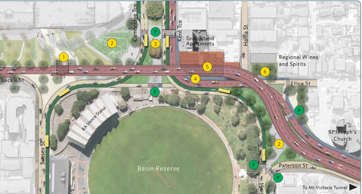
Yes, I am talking about the plans for the euphemistically titled “Improvements to the Basin Reserve”, otherwise known as Overpass Option One or Overpass Option Two. Here they are below: just the top portion shown here, cos that’s where all the action is:
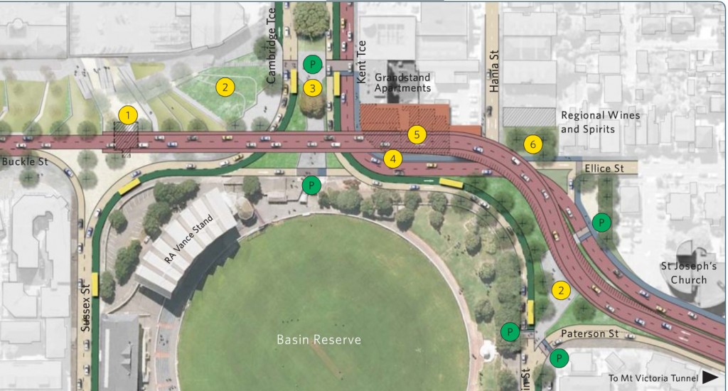
That’s the “preferred” option, seeing as it is simpler, cheaper, and straighter than the second one, which in reality no one in their right mind would want to see tootling through the city.
“We’re also considering the option of adding a pedestrian and cycle facility to the bridge, which would cost about $8 million. Pedestrians and cyclists will still be able to use the streets under the bridge, so we have to decide whether providing this alternative facility justifies the expense.”
We are however offered a choice with our choice – do you want fries cycle-lanes and footpaths with that? Well, do you, punk?
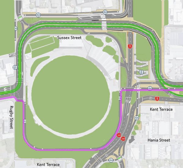
Here’s option two, the wild card option. That’s cos it will make anyone in the “Grandstand” apartment block a bit wild….
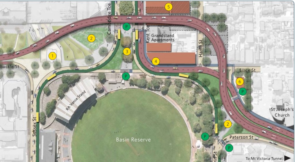
Now seriously, that’s just being silly. Does anyone really expect anyone on the planet to vote for that one, except perhaps five old men at the Cricket ground? The chances of a giant snaking roadway like that, completely alien to Wellington’s topography, and racing between buildings like a bad mash-up of Blade Runner and Metropolis, is really just a non-starter. But, like Jeremy Paxman on a roll at University Challenge, “I’ve started, so I’ll finish”. The roading bods at Transit sorry NZTA (still can’t get used to it) have clearly stuck this ugly monkey in as the pig in a poke, the Claytons choice, the Overpass you vote against so that they get the Overpass they want to.
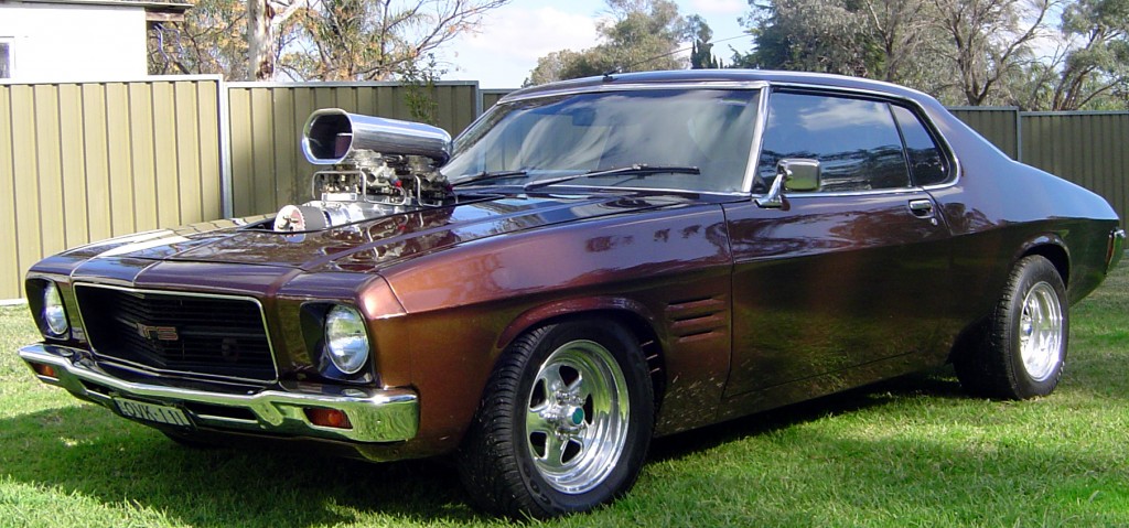
So: one choice that narrowly skirts the hemline of the Basin Reserve, with the dull roar of traffic just drowning out the gentle thwack of willow on leather. The other choice that is not a choice at all. Both of them are scraping gently against the concrete walls of the St Joseph’s church, the powerful roar of the mighty Prius taxi drowning out the Word of God. Bad luck to the Catholics for building that side of the ditch. Now I have nothing against a good high-rising, narrowly skirting, gently scraping piece of urban knitting, but this seems like the petrol-headed boffins down at NZTA have been sniffing more than just the exhaust of a 69 Monaro. They’ve had their noses firmly pressed to the flanges of the lake pipes of a fully modified Funny car about to snare off down the Meremere back straights, and swallowed a little too much of the nitrous oxide to be fully functioning in the modern world.
There are of course many other choices, unshown here. Deep in the bowels of the NZTA reports come the news that other options were considered – but they’re not really telling you what they are:
“We considered building a tunnel around the Basin Reserve. However, because it had to extend between Paterson and Taranaki Streets to be viable, it would have been significantly more expensive to build than a bridge. The tunnel construction would also have been difficult given the need to build it in an old swamp. We also considered street-level options. However, while they were cheaper than a bridge they provided fewer benefits and were not as good as a bridge in separating SH1 traffic from local traffic, particularly buses and possible light rail. We believe the bridge will best meet the needs of future generations, particularly if they want to upgrade the Inner City Bypass.”
“We also considered”… Now that’s not very reasonable at all. In my job, if we did a report that said there were other options, but we’re not going to tell you about them, or report and compare their advantages, disadvantages, costs etc, I’d be down the road without so much as a second glance. The same should go for NZTA. I think that the first thing you should all do is send in a submission straight away to the NZTA and say:
“No Way, Over-Passe.
I vote for Neither of the two options presented.
I demand to see a Full and Fair evaluation of all the other schemes that you have had for the last 2-3 years.”
Hell, 5-10 years even. How long has this beast been in the back cupboard – which century did these guys crawl out from under? Once we’ve got the other options on the table, and the cost basis comparison stripped back and laying bare on the slab, only then will we pick over the bones of these two. We’re waiting for the Community vision fight back scheme – the Overpass that you (quite simply) Don’t Have. It’ll come from somewhere, of that I’m sure.
Let’s move on, shall we?
What about this tunnel then? This second, proposed Mt Victoria tunnel? Because, let’s face it, the works to the Basin make absolutely no sense unless the 2nd tunnel is drilled at the same time. “Solving congestion” in one spot and then allowing it to choke up again a mere 100m away is a kind of no-brainer – ie the kind of thing only someone with no brain would do. So, seeing as the boffins at NZTA are clever chaps and chapesses, they’ve provided the plans for a second tunnel as well. Here it goes IN, on the city side of Mt Victoria:
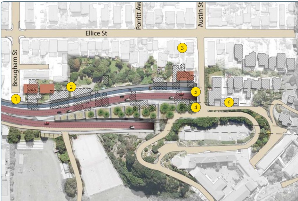
Yes, I thought you’d like that one. They seem to have taken to heart my suggestions that one tunnel go in above the other, except that even here they got it wrong: the new tunnel should go LOWER down the mountain than the old one, so that you don’t have to destroy so many houses / lives / neighbourhoods along the way. What seems to have been drawn here is something deliberately vindictive – targeting every house they can, and taking out the approach road to the local schools that cluster around this portal.
I might gnaw over this bone some more another day, but for now I’ll finish off this post with a simple showing of it coming OUT the other end of the tunnel: the return of the Haitaitai Thai Tie. Clue: its really a Knot. Or a Not. Whatever: here it is:
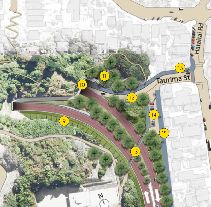
I’ve kept the picture size high so you can see it clearly – the yellow dots etc are from the NZTA website, so you can pick up the notable features. There’s information on their website if you should want to know more about these points. But I think you can probably see quite clearly enough what is planned to happen here. There is a nice simple path going from the new tunnel’s pedestrian / cycling route, right up to the edge of Haitaitai. This continues off down Ruahine St, which is currently just one way each way, and is now due to be two to three lanes each way – yes, Three. We’re not sure why. Future proofing, no doubt. Guess why: because traffic on this route is due to climb by 80%, according to NZTA predictions. Eighty per cent. Can you believe that ? Not sure that I can.
Coming soon: Ruahine Street and Wellington Road – abandon hope all ye who enter here. Or – is it really all that bad? in the mean time, let’s talk Basins and tunnels. What do you think?



I actually prefer option one. Mostly because it seems more logical. As long as they install a permanent or temporary shield to prevent people being distracted by any major event going on at the Basin. There is no need to push it out too far away from the basin. Heck, during major games they could always cut the lane down to one furthest away from the basin to cut down on noise.
I think once built this will all fit in quite nicely with the undulating hills around that area. There is quite a dip between the war memorial and Mt Vic tunnel.
I wrote back to NZTA supporting option one and all other suggestions as I worry that they will be drowned out in negative feed back.
I find it amusing that the language used by people who are against roads such as this hints that they feel that there is a hidden agenda over at NZTA. I’m not sure what that agenda is, roads cost money and so why would they just go and build roads for the sake of it? This is typified here:
“What seems to have been drawn here is something deliberately vindictive – targeting every house they can, and taking out the approach road to the local schools that cluster around this portal.”
What on earth is the basis for this claim? That people in government want to level every house in the country just to pave it with asphalt?
Mechaniker – “What on earth is the basis for this claim?” – Just that a 2nd tunnel could be perfectly well integrated into the area without having taking out 13 houses in Paterson St, if the tunnel approach was to be lower, rather than higher. It seems extraordinary to me – evidently not to you. I’m clearly not saying anything as silly as “That people in government want to level every house in the country just to pave it with asphalt?”
I’m glad to hear you support the scheme – somebody has to.
Gee. How uninspired.
Of course the best solution is a tunnel. But in my mind the most sensible option for all users, not just cars, when considering the costs is four east/west lanes along the northern edge crossing with four north/south lanes routed via Sussex St and an at grade intersection. Designed such that it can be upgraded to a northsouth overpass at that point (where the numbers 1 & 2 are in the top pic) with the east/west traffic entering into a tunnel under Memorial Park. This may require some demolishion on sussex st of all those jesusfrackingugly apartment/hotel/student flats things that now border it.
Add in some cutting and lowering/smoothing of the eastern side and you can then cover these with a nicely conceived pedestrian bridge to provide a smooth north/south pedestrian and cycle linkage. Perhaps if done by someone creative it could bring the embankment of the basin reserve right over the road in some way, linking the basin right into Hania/Ellice Sts.
I like the new walking and cycling lane lane and thats it.
Having a massive motorway through here seems excessive. Even the renderings look terribel when they usually are designed to look good no matter what.
You havent mentioned Buckle St. The proposal is for the national war memorial park to have State Highway one rumbing through at ground level. Apparently NZTA are in an argument with Min of Culture and heritage about who will pay for it to go underground.
The NZTA reps down at the basin reckon this ‘imporvement’ would reduce traffic by 30% but that will only last a few years as the space gets filled up again. We will end up with this concrete python choking the Basin area with traffic.
Did they seriously investigate any PT options??? Will we ever know?
You’ll notice in the report it talks about an expected increase of traffic over the next 40 years, and a couple of pages later, notes that in the most recent year sampled (2006 – peak of the boom) traffic *dropped* by 8%. Not to mention that they rely on an assertion by WIAL of traffic doubling by 2030, whilst all indicators point to a substantial fall in air travel over that period.
I’m writing a substantial submission on this, and propose to ignore the loaded questions (typical WCC – ask for submissions, but load the questions to drive the responses in one direction).
Celia has changed nothing.
‘We believe the bridge will best meet the needs of future generations’
NZTA listen very carefully, future generations do not want a bridge, fyler over, whatever you want to call it. Anyone else backing such an insane scheme are stuck in the past. Past. Future. Please understand the difference and accept that this is a past generation scheme. Keep it to yourself and the past. Thanks.
I notice there are some open days coming up where you get to talk to some of the specialists who developed the proposals. Should be fun.
Visit our information centre in the RA Vance Stand at the Basin Reserve (entry from Sussex Street). The information centre is open Monday to Friday from 10am to 3pm except on Thursdays when it is open from 3pm to 8pm.
Come to a project open day. Open days give you the opportunity to talk to some of the specialists who developed the proposals. Open days will also be held in the RA Vance Stand at the Basin Reserve and will be held on:
* Saturday 9 July from 10am to 4pm
* Saturday 16 July from 10am to 4pm
* Sunday 17 July from 10am to 4pm
Maximus, I’m sure you know the reason as well as I do, why the proposed tunnel is in the position it is?
I fail to see why the existing half-drilled tunnel should not be used. It’s not as if we want to make Mt Vic into a block of Swiss cheese. I would rather the stability of the rock take precedence over several Victorian houses.
Also there is the matter of messing about existing infrastructure. That said, I cannot see the pump station/sub-station/whatever-it-is that is housed in the dark green building by the Basin-side portal, so perhaps this has already been taken into account by the Engineers.
Those quips aside, NZTA can suck a big fat one with regards to EITHER plan. There is NOTHING in their blurb which mentions and ‘overpass’, only a ‘bridge’. Well pardon my français/Hone-speak, but that is a big mother-effing bridge.
Erentz has got some great alternative ideas. Grade seperated lanes don’t necessarily have to mean a great big dirty flyover. Why can they not sink one road down a bit and have and earth embankment (probably with retaining wall to contain some of it) supporting a road above? This could also incorporate at small pedestrian & cycle tunnel/bridge structure. Main things being: it won’t so high; it could be planted, therefore create more of a natural boundary (as opposed to a stonking great bit of floating concrete); if in 20 years NZTA (or whatever they are rebranded by then) decide it was all a huge misunderstanding, dirt is a lot easier to disperse of than concrete; some of the fill could be sourced from the newly-drilled tunnels, keeping costs down. Sure there will be a need for a structure so that traffic can go where it needs to, but one several magnitudes smaller than those proposed.
I’ve got my thinking hat on and would love to make a submission on this. Pity that NZTA and the Tunnel Alliance operate under a mechanism that doesn’t require them to take feedback into consideration; that these aren’t considered or regarded as submissions as under a project that has RMA requirements.
And Rich, I agree that the loaded questions are complete & utter bollocks. However, the blame does not lie at WCC and Celia’s feet though. This time it is Head Provost Steven Joyce and NZTA’s grey-minded comptrollors that you should be cursing.
“Just that a 2nd tunnel could be perfectly well integrated into the area without having taking out 13 houses in Paterson St, if the tunnel approach was to be lower.”
Ok how that would work exactly? How much lower would it need to be? To keep pushing it you must have some ideas. Last week you kicked for touch and said NZTA could work that out. What if they already have and it doesn’t? It looks to me (using my thumb and index finger as a theodolite) as if you’d have to start going under at the level or lower than the corner of Kent Tce/Ellice St, given the first house on Paterson St you want to avoid is on the corner of Brougham that is about 10m above the Basin. Is the church to be avoided too?
Oh and last week you said were “not actually proposing that we have a double decker tunnel” but this week you apparantly were…
PS image #8 here http://www.nzta.govt.nz/projects/mt-victoria-to-cobham/gallery.html seems to show the tunnel lower and more forward than the current one. Still no houses though :-)
Just saying, when St Josephs was rebuilt on the site it currently sits on, transit was extensively consulted. In fact a land swap was put in place so that transit got the land it wanted and the church could move closer to Ellice St. By the looks of those plans transit should have considered more thoughtfully where to tell the church it could rebuild…
Seamonkey – re your comment: “I fail to see why the existing half-drilled tunnel should not be used.”
I’m not an expert on tunneling – in our town, who is. And I have no idea how big the existing ‘pilot’ tunnel is – evidently big enough for someone to walk down, but not big enough for cars. However, my understanding is that, all things being equal, tunnelers would probably rather cut a nice fresh line through a mountain than to have to smash through existing concrete and steel reinforcing etc – as it makes a mess of the cutting heads on their excavation machinery. A nice diamond tipped drill can cut easily through a steel plate, but generally stray bits of steel in an otherwise clear piece of rock can rip your teeth off – sort of like biting into a nice meat sandwich and finding some old kebab skewer in there.
Insider – hmmm, interesting, I wonder if you are actually an insider to the actual NZTA – I guess we’ll never know. Anyway – thank you for coming along and commenting – the more that join in the better.
The natural fall of the land out of the Mt Vic side of the tunnel is a relatively steep incline down to the Basin. It follows therefore that a higher entry point to the new tunnel is a logical conclusion if you have an overpass leading up to it. On that basis, NZTA are entirely right. Having the tunnel entrance right up there is fairly high up – I took a hike up there the other day, and Paterson St is a very steep little street at present. A higher tunnel entrance would certainly wipe those houses out.
However, there are differences if you start off by assuming that a ground level solution is possible in the Basin. The tunnel could therefore start at a lower level – at or below that of the St Joseph’s church. It would therefore also come out at a lower level on the far side in Haitaitai I presume.
“Ok how that would work exactly? How much lower would it need to be? To keep pushing it you must have some ideas. Last week you kicked for touch and said NZTA could work that out. What if they already have and it doesn’t?”
Well, if they wanted to take me on and pay me for doing their design work, or furnish me with all the relevant heights and survey data, I’m sure that I could work out the answer in less time and less money than the 2 years they’ve taken so far. My sketches so far, as you have seen, http://eyeofthefish.org/Fishing-the-Basin/ are at a pretty rudimentary level, seeing as I have no data and am employed more fully elsewhere (under the see, blowing bubbles, to borrow an unfortunate MJ metaphor). I would like for nothing more than for NZTA to say “we’ve looked at that, and here are the sketches and the costings and it doesn’t work because of X, Y, and Z.” But until they publish that info, all we can do is presume that they just haven’t been bothered to do so.
Thank you for your comments Fish. I agree with what you are saying. As a old time resident of the Eastern suburbs and past student of Wellington East Girls College I can see no sensible reason at all for having the overpass or second tunnel for cars! A second tunnel for pedestrians and cyclists does however make sense.
This project is being created for the leaming like cars of the eastern suburbs. The 80% increase in traffic is just plain ridiculous. And also shows that NZTA are not realistically considering a light rail system for Wellington. Haven’t NZTA heard about peak oil? Let alone other factors of declining finite resources.
Also of note is that the overpass and extra tunnel are only for cars and will not stop large, oversized and dangerous goods trucks and vehicles going around the bays between Evans Bay and Oriental Bay. This factor seems to be missed by everyone. Therefore the cyclists, recreationalist, residents and other users of this route will still have to contend with these vehicles.
Mech… Love the motor but surely it’s designed for straight line speed! Too many curves on these schemes to get some real enjoyment from that beast!
The distributed flier has a load of interesting pics with as many trees as possible obscuring the asphalt and concrete are worth showing as exemplar silk purses – perhaps that’s another discussion.
The view up the twinned terraces is a key one in Wellington – I’m one that thinks an overpass here in any location needs rethinking. If it cannot go altogether then at least it should act as a decent termination to this vista.
Good to see Wellington finally getting passionate about an urban issue – there is so much more to say…
I don’t know why the NZTA types have taken so long to produce a design that is so breathtakingly ordinary. Given the constraints of topology, internal combustion and the terminal lack of imagination that characterizes traffic engineers, we arrived at exactly the same solution as Option 1 in about ten minutes some three years ago – and it only took an hour to design it in SketchUp. The only difference is that our design was meant as a deliberately ugly post-modernist ironic riff on how bad a flyover could look. Little did we suspect NZTA would play it for real, instead of playing it for comic impact.
The Arch Centre would like to respectfully point out to Maximus and others that NZTA have indeed put a lot of their background information on line. We’ve discussed it briefly here:
http://architecture.org.nz/2011/06/29/lets-not-get-pwned-by-the-ronster/
Most importantly, the source of NZTA documents is named as:
http://www.nzta.govt.nz/projects/basin-reserve/publications.html
and also:
http://www.nzta.govt.nz/projects/basin-reserve/docs/basin-reserve-options-report.pdf
There was originally options A-F.. most seem to be padded out versions of the final two… one of which seems thrown in there to ensure we pick the other.
The other options included a tunnel as mentioned… which was estimated to cost possibly 4 times the price of the golden flyover. Of course this is the option Wellingtonians want so they were never going to give it to us to preview otherwise they might be pressured into taking it more seriously.
The thing that annoyed me the most about this weekend’s public announcement was the fact that they removed the “in Basin” renders from the final publicly presented artwork. The “in Basin” renders which quite clearly show the impact of a mass of steel and concrete hovering menacingly over the long on boundary.
And I also noticed that they conveniently ignored the possibility of a cricket ball strike… a very real threat after last season’s Adelaide Road hit…
Agree with erentz and this seems to be what the arch centre is proposing. Although the problem with Sussex st is that you only have 3 lanes to play with, and I’m not sure if bulldozing crappy apartments (that the nzta don’t own) on Sussex st to get 2 lanes going each way will be seen as a good option. What about having 3 north/south lanes on Sussex and 1 going round the eastern side (Dufferin St). Because the eastern side would already be jam packed with 4 lanes you could ask the basin to cut and cover through the outside of the eastern embankment to get the extra north/south lane in.
Also this flyover crap needs to be facebooked! It worked for Wellywood and the Macsyna book, put them under some pressure.
Option F please – tunnel from Paterson to Taranaki. Do it once, do it right.
[…] soon, but if you’re as appalled as we are (and if you aren’t, you might want to read Eye of the Fish’s excellent commentary on the proposal) we’d like to point out that there is a protest at Parliament tomorrow, Wednesday July 6th, […]
Is that a fully blown HQ you’ve included a picture of?
Agreed NZTA have brains of custard and whilst many would consider that car uncommonly ugly I’ve driven something remarkably similar and it’s some of the best fun you can have with pants on.
Just sayin
Absolutely horrified and appalled by this: as 60 Mpa rightly points out, that’s a picture of an HQ Monaro. The HQ Holden debuted in 1971, SO WHY DOES THE ACCOMPANYING TEXT MENTION A 69 MONARO?
Oi Slag! You talking to me? (Always wanted to say that to someone…)
You could do what I did – google the words 69 monaro – and that’s the result. Number 2 on the image search – so don’t blame me if it’s wrong. Of course, it turns out you’re right – But – isn’t it mighty fine anyway…? Now you can make all those brrrmmm, brrrrmmm noises with your lips.
Incidentally, the article behind the picture (http://www.onlinemodelcars.com/holden.php) says:
“In 1969 the Holden Monaro GTS was given a minor facelift, the main difference between the 1968 HK Monaro GTS and the 1969 HT Monaro GTS was the use of a plastic grill over the previous models metal one….. Along rolled 1970 and Holden released a totally new Holden the HQ, which was the most radically new model ever produced by Holden since 1948. The Holden Monaro GTS shared all the benefits of this new model, which delivered new levels of structural integrity and a totally new rear suspension layout that gave the Holden Monaro GTS great rough road stability and grip. The HQ Holden Monaro GTS shared influences from both the US and Europe, the recessed grill reflected European trends while the bulging muscle lines above each wheel arch and the wrap around bumper with lights was straight from the Pontiac GTO….. with its blacked out grill looking like a road devouring intake, the pillarless coupe roofline and the wrap over rear window are breathtaking in their simplicity and beauty. The Holden Monaro GTS coupe and 4 door fitted with the Chev 350 are rare beasts as most buyers at the time opted for the home grown 308. So long live the mighty Holden Monaro.”
now if only we had some long stretches of road in which to take it for a ride….
60 – on the internet, nobody knows if you have your pants on…
Rich – “Celia has changed nothing.” I feel duty bound to point out that this scheme is all NZTA, and nothing much at all to do with WCC and CWB.
DD – (should I call you double dee?) Its hard to tell – the road does look a little closer. Still, at least they haven’t proposed to demolish it… that’d really piss the Catholics off – and if there is one thing in life I’ve learnt, it’s: don’t piss the catholics off. Just ask 60mpa.
Just a question to NZTA or anyone else that could answer: if you’re coming from the airport on this, and you come out from the tunnel and onto the overpass – and want to go somewhere other than Porirua, how do you get off? Is there anyway of going left down to Adelaide Rd, or right down Cambridge Tce? Or do I just have to hang on until Tory St or Taranaki St ? Anyone know?
People talk about using tunnels instead of bridges etc, but yet no one has thought about the cost. Who is expected to pay for keeping everything hidden? As a taxpayer I sure as heck don’t want to see the Government local or otherwise fork out for a tunnel when a bridge is perfectly fine.
I think if you polled most people there would be a higher percentage for this proposal. I talked to two people in the office where I work, and both thought it looked like a fantastic idea, and were sad that it was going to take so long to build. That is by no means a scientific sample, but I think you will find that the common joe is just happy to have the traffic problem fixed around that area and care less about some utopian “urban planning ideal” that comes from some happy place in one’s mind where cars don’t exist and everyone walks or cycles or uses monorails.
Mechaniker – not to rain on your parade or anything, but when the Ngauranga to Airport Corridor Plan was being consulted on, a full 87% of the many thousands of submissions were opposed to a flyover at the Basin. So this alleged ground-swell of support for a flyover has not been evidenced in any of the submission rounds, your mates at work notwithstanding.
As far as the costs go, the flyover and tunnels and stuff are already hundreds of millions of dollars in the hole, before the inevitable NZTA cost over-runs. The whole project will cost something north of $500 million, yet return barely more than $250 million in economic benefits, according to NZTA’s own consultants. So if you wanted to make an economically rational decision, you’d implement a ground-level design at the Basin that would produce 90% of the benefits for maybe 10% of the money …. or if money was no object (thanks for the blank chequebook, Steven Joyce!) then you’d build the Architecture Centre’s cut-and-cover approach, and get some halfway decent urban design out of it in the process.
NZTA like to keep the traffic moving pretty much at existing capacity while ‘improving’ their roading structures. I imagine this is why they don’t look into on-grade options with much fervour; where would the cars go in the months/years required to rearrange the grades? So much road rage! They’ve got experience building flyovers without interrupting traffic much (the Viaduct ‘improvement’ in Auckland). They also like to use the land area they have already purchased, probably back in the 60s, to locate their road improvement, because otherwise they have to negotiate with irritable landowners who can (or at least have to be heard out while trying to) impose conditions on their schemes. All this adds up to the opposite of the ‘Do it once, do it right.’ approach. It seems to me that NZTA have immovable blinkers about some constraints (rerouting traffic temporarily) and extraordinary mandate powers about others (bowling houses) which leads to the inflexible designs they propose. Which then result in not much/no improvement at all, as discussed above in the mishmash of statistics NZTA use to explain their proposals.
Does anyone know why the Vitoria Park/Fanshaw St tunnel got the go ahead? Maybe we can learn something from that…
Mr Joyce, if we have an allocated funding for this project, how about we go with the Arch Centre proposal for cut’n’cover and use the savings to do a cut’n’cover on Jervois and Cable, just dropping them a couple of metres and grassing over in sections.
Not completely like a tunnel but enough to fully connect our fine town with it’s best asset, the waterfront.
I’d vote for that, with pants on.
About the 80% traffic increase – if you read the report this includes people who currently drive through Oriental Bay and Newtown switching to the new route. A lot of the benefit of the flyover and tunnel will be easing congestion in those places.
Sorry to be a link-whore, but there is more discussion of congestion-related issues over at Arc Centre: http://architecture.org.nz/2011/07/06/traffic-congestion-part-1-why-are-the-dompost-being-such-d1cks/
Specifically, and in support of Save the Basin’s comment above, that most Wellingtonians are satisfied with their present ease of commute. This is based on actual, you know, research, rather than anecdotal stuff pulled out of who knows where…
Mind you, all the negativity that is emanating from the mouths of the whiners in the minority might just change that satisfaction, and have us all complaining about that 1/2 hour commute (heaven forbid)!
Steve – Hazardous freight cannot go through the tunnel, and I suspect transportation ‘improvements’ near the Basin will not deter those who want to take their visitors on a more scenic route to/from the airport. Newtown would also be subject to a variety of multi-destination trips, which would also not be diverted onto SH1 with or without said ‘improvements’.
There is also the fact that Newtown isn’t really subject to the same peak congestion profile as SH1 (and neither is, I venture, Oriental Parade). Their traffic demands are of a wholly different nature, and it is possibly a little mischievous to conflate them in order to arrive at an 80% figure? But, they’re the experts I guess…
I do not understand why an overpass is the automatic solution when a tunnel is too expensive. I agree street level is not desirable – the Bypass not being a bypass at all shows that – but why not an underpass? For example, two lanes going straight from Buckle to the tunnel that are at lower than ground level until they reach the approach to the tunnel, with a ground level lane of traffic on either side at ground level for street traffic round the Basin.
These underpasses are used overseas in many places to let through traffic avoid intersections, and they seem a perfect solution here to me.
where I work we all have agreed magical unicorns will fly us over the rainbow, so there for everyone in the city must be the same.
As for this “traffic” – please get a damn grip. I’ve come to realise the average kiwi thinks it’s traffic if there’s one person in front of them at a traffic light. Bunch of damn whiny complainers. It’s amazing how the loudest and whiniest are the ones that think that people objecting to destroying the city to help their commute by 5 minutes (if that), are the complainers. Sit in your car for hours on a sunday trying to go 5 miles in an actual city, and you will get some perspective of what traffic is. What this is is called “living in a society of people”. Yeah it would be fantastic if it was just me and my magical unicorns flying through the sky but that’s not the way it works.
Could someone let me know where the 80% growth figure is reported by NZTA, I’m feeling a little inclined to do a little further digging into the rationale for that figure…
I found the reference to the 80% figure in the recent brochure (p16) – but note that the 80% increase on the SH1 route is projected as a result of the network ‘improvements’. They are arguing that the improvements will induce demand on SH1, taking it from other routes (i.e. Newtown, Oriental Pde). Perhaps it was only me thinking that they were stating that there would be an 80% increase in SH1 traffic, hence the need for the improvements (which is kind of the opposite of their argument)??
Anyway, the TomTom graphs featured in the blog post I linked to above suggest that peak congestion at both Newtown and Oriental are not really significant issues – even by local standards (leaving alone international comparisons)… Which is yet another example of how this project is rather an expensive way of addressing congestion that doesn’t really exist…
mechaniker – the biggest problem with this flyover solution is that it is unliekly to actually ‘fix’ the traffuc problem for more than a few years.
m-d – The 80% number seems to come from conflating projected traffic growth (not substantiated in the real world) with projected growth from the airport (yeah right) with a large dollop of induced demand, on the assumption that the majority of vehicles currently using Oriental Bay will go through their shiny new tunnel.
Leaving aside the dodgy mathematics – which seem to use the phase of the moon on the Chief Executive’s birthdate as the traffic growth multiplier – Karo Drive conclusively proves that this 80% figure is complete nonsense. You’ll recall from the Inner City Bypass debate that NZTA used the same logic back then, asserting that traffic volumes would fall on Jervois Quay as a result of the new road, which would allow the Quays to be reduced to four lanes – which, of course, turned out to be utter bollocks. And it’s easy to see why there are still six lanes along the waterfront – Karo Drive is barely faster than the roads it replaced.
And we’re going to see the same effect in Ruahine Street. There will be more lanes, but there will be new sets of traffic lights and a lowered speed limit, so both local traffic (Hataitai residents) and through traffic (taxis to the airport) are going to suffer delays at the lights and longer trip times. Which in turn means they won’t abandon Oriental Bay, as the total journey times will be barely different to today. So effectively NZTA is proposing to spend something north of $500 million and wrecking a heritage precinct to do seven-tenths of exactly bugger-all to journey duration.
[…] criticism of the flyovers is pungently to the […]
The Architectural Centre has just published their Critique of the NZTA scheme for the Basin Reserve Improvements. Available here:
http://architecture.org.nz/2011/07/14/does-the-nzta-scheme-measure-up/
[…] have been proffered to the public by the roading lobby. That’s a real pity – as I’ve noted already, and which Scoop picked up on, one of these “options” is not really even slightly […]