We have an Accord.
No, not one of those big Hondas, that glide smoothly along the tarmac with the stealth of a ninja, but we – the Royal We – Wellington) have a Housing Accord, signed between the Government and the Council. They’re promising to play nicely together in the sandpit – Mayor Wade Brown will still be here after the election, and I’m assuming that Nick Smith will be as well. Sadly. So what does this mean for Wellington? Let’s have a look:
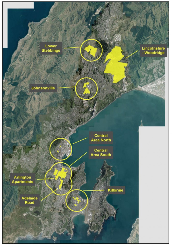
As can be seen in the official map here, the areas are spread around, and are of -in some cases – considerable size. The accord comprises “eight special housing areas (SHAs)” and, apparently, some “qualifying development criteria”, although I’m really not sure what those criteria are. Here’s what the official Press Release said:
“These SHA recommendations will now be sent to the Minister of Housing for government consideration and approval. The Council also agreed on a package of housing development incentives to help kick-start qualifying development in the SHAs. Approval of the SHAs will allow the Council to apply special planning and consenting powers to qualifying developments under the Housing Accord and Special Housing Areas Act (HASHA). Qualifying developments in SHAs will still be assessed against the relevant district plan rules.”
“The eight SHAs and qualifying criteria recommended to the Minister are:
•    the greenfield areas of Stebbings Valley and Lincolnshire Farm-Woodridge (10 or more dwellings)
•    the Johnsonville and Kilbirnie medium-density residential areas (two or more dwellings)
•    Adelaide Road between John Street and the Basin Reserve (two or more dwellings)
•    two parts of the central city; Te Aro and Thorndon (two or more dwellings)
•    the Arlington apartments site in Mt Cook (two or more dwellings).”
“The incentives package to help/encourage housing developers includes:
•    a ‘one-stop resource consents shop’ to process consents under the HASHA Act
•    financial incentives such as deferred rates increases and waiving pre-application resource consent fees, and targeted investment through infrastructure to support growth and public space improvements.”
The SHA areas are therefore in two main locations – either within the traditional Wellington area, where you can apply for two or more units – ie small scale infill on brownfield sites – or the alternative greenfield development areas in the sticks, where the Council is expecting multiple housing of ten or more houses. I’m intrigued, and a little perplexed. Let’s look at the northern SHA first.
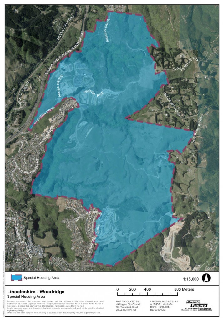
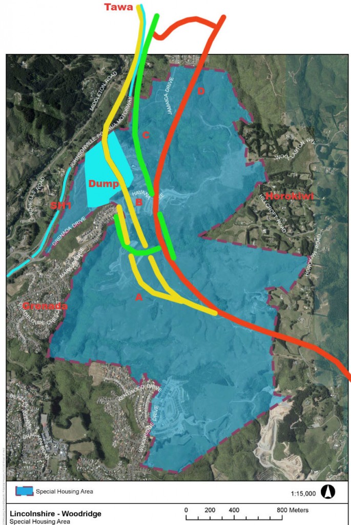
That’s the area of Lincolnshire Farm. It’s the top of the escarpment that stretches across the uncharted part of Wellington from Horokiwi to Tawa, that I went to visit a few months back. There is rolling hilltops with great views, deep ravines in places, no doubt some harsh winds at times, and presently its all a bit inaccessible. It’s also the area that developer Richard Burrell was recently trying to get the Government interested in as a new site for an airport, but most importantly, it’s also the area that NZTA are proposing to build a Link road through, between Petone and Granada. No, not the Takapu Valley that Gloria found for me, but just south of that. Undoubtably the new proposed link road is going to be the key to unlocking this particular stretch of future Wellington.
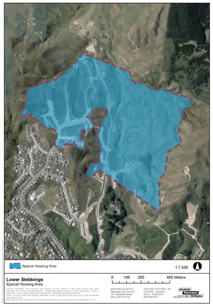
Close by is Stebbings, which also perplexes me. I confess I’ve never been there, something I’ll clearly need to remedy, but I’m not sure why anyone would want to live there. Suggestions please!
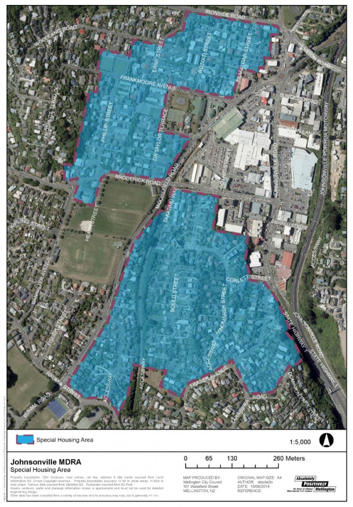
Johnsonville, of course, will be a site of contention. Everything is a site of contention in Johnsonville. It’s not a bad little place, J’ville, but they have one of those backward-looking local residents organisations, ironically called the Johnsonville Progressive Association. It is, of course, anything but progressive, and instead wants everything to stay as it was in the 1950s. But, beset by the motorway, and subject to a potential future mega-mall in their midst, J’ville is changing, and somehow this SHA needs to help make it better. There is an excellent piece on the urban grain of J’ville by local blogger Alf Rune, available here, as he walks his way north. In that post, he describes this little hamlet thus:
“…that reminds me that Johnsonville was once the future. For the stretch of road between here and Porirua was the first motorway in New Zealand, constructed smack bang in the optimistic middle of the Twentieth Century. That was indeed a nationally significant moment: the birth of the motorised dream whereby speed, space and convenience added up to freedom. The northern suburbs bloomed along the motorway’s banks, fed by cheap oil and living on the butterfat of the land, attempting to translate Godzone’s bucolic origin myths into the burgeoning city, one quarter-acre at a time.”
Coming up in the next post, we’ll take a look at the inner city SHA.
Postscript: I’ve just pieced together a rough outline of where the proposed NZTA Link Road goes through the Lincolnshire Farm SHA. Thought it might be interesting to take a look. The 4 options are shown – A, B, C, and D. In its wisdom, NZTA decided only to look at routes C and D, and if they pay any attention to the amount of feedback they got over Takapu Valley, they’ll steer clear of that. Which leaves only C as the likely route. However, they’re nasty, callous, over-bearing, haughty disregarders of anything anyone gets back to them on, so nothing is really off the table.


Stebbings has no inherent virtue beyond the fact that it is the front of the wave of houses moving North through Churton Park.
Assuming offramps are expensive, Stebbings is the bottom end of the motorway exit that has the top end which went to the short-lived landfill and now goes to the Lincolshire/Woodridge area.
If you’ve not been there the Stebbings area has a newish shopping area and a loop road. Very Whitby.
Stebbings is also very near the new Amesbury Primary school that opened in 2012, ( its the big building in the bottom left quardant of the map.
In Terms of Greenfields developments, its not a too bad location,
It is close to current road links, has a new school and town centre/supermarket and in the long term, if there is enough growth in the this and lincolnshire farms there is the possibility of developing a new railway station at glenside on the Kapiti line,
I admit that I too am confused by these Special Housing Areas. The advantages that the Council list are only:
•a ‘one-stop resource consents shop’ to process consents under the HASHA Act
•financial incentives such as deferred rates increases and waiving pre-application resource consent fees, and targeted investment through infrastructure to support growth and public space improvements.â€
Really? That’s it? Seems a little light on detail? And most importantly – how does it work in Johnsonville where the existing houses are quite plentiful, as opposed to out “in the sticks” (as you put it) where there is mainly grass at present?
Am more interested in the plans in the city itself.
Good that they are planning for new housing, and hopefully some population increase. But density is Wellington’s appeal, not more cul de sacs!
cle – they’re coming up next. Soon.
Alan – like you, I’m perturbed. If that is all there is, why the big fuss? Why couldn’t the Council just do these moves anyway? What about it needs central Gov input, and a legal Act, when it all seems like not-very-much?