For over four years now the capital city of New Zealand has been waiting for the so-called group of experts to give us an answer on the future of public transport. LGWM have been conspicuous by their absence in providing any form of detail, at any part of the system. Yes, there is obvious bickering over the cost, the route, and even the type of system to be used, but one thing seems obvious to me: we need to make a start.
We need the planners of Wellington’s public transport future to put a stake in the ground – actually, no, we need them to put a whole line of stakes in the ground and then dig a trench along that line. But some things seem quite simple to me. There really is only one logical answer to some parts of the puzzle. And instead of starting at the beginning of the line, I’m going to start right in the middle, at the point which seems to annoy everyone the most. The Basin Reserve.

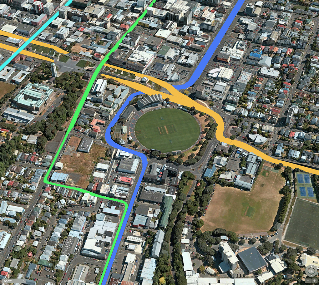
Every week for the last ten years, we’ve had smart-arses writing to the paper saying “just dig a hole under the Basin” and there has been at least one of those this week. You’re boring and you’re wrong. The answer is pretty much dead simple, and NZTA have known they were going to do this the day they lost the Basin Bridge enquiry. The picture above shows the plan – I believe the only possible plan – of what will, without a doubt in my mind, eventually happen at the Basin. Its all just so bloody obvious.
Yellow is the route that the vehicular traffic to and from the airport will take. It will follow much the same route as the doomed Basin Bridge, but instead of building a bridge 250m long and 8m high up in the air, it will descend from Mt Vic down to the ground level at the Basin, and then rise up to the Arras tunnel via the natural slope between Buckle St and Cambridge Tce. No big long bridge necessary – and it will just need a couple of small local bridges to achieve grade separation at the Basin. Job done. They could start this one tomorrow, it is so easy. You’ll notice that there is a second yellow stripe running parallel to the Arras Tunnel – that’s my pick for the new east-bound section of SH1. Again: fairly obvious, especially as the route sits there, empty and waiting. Not a single building needed to be knocked down to create this route.
Green is what I am proposing as the logical bike route into the city from places south. Trying to get a bike route round the Basin is fraught with challenges, and I think it is best to avoid it all. Make Tory St into a pedestrian and cycle-friendly street, following the route of the green path along a level of low-resistance. Imagine all the restaurants down Tory St being able to have seating outside on the footpath just so that they can turn into a proper European-style bistro.
Turquoise in the top left is my pick for the new Public Transport system – which for simplicities’ sake is just this: Light Rail up the centre of Taranaki Street. My guess is that it will cross over the Karo Drive traffic, and so there needs to be a major redesign. More details on this will be forthcoming (from Eye of the Fish) in the next few days and weeks.
Blue is the final colour, depicting both the main traffic route for cars and trucks, but also the route for buses, because one thing is for certain: there will still be buses as well as Wellington Light Rail. The blue path can fit in easily, and will cross over under the new SH1 routes, with two small 20m long road bridges. The cost for these will be minuscule compared to the cost of the big Basin Bridge that was proposed a few years back.
The rest of the roads I’ve left in their natural grey, as I believe there will be no change. They won’t, for example, take the Arch Centre’s proposal to green over the Dufferin St end of the Basin roundabout, as they don’t have the brains or the balls to make such a decision. It’ll stay as road – and with some clever redesign, somehow manage to sort out the ridiculous afternoon school pick up issues that arise from having several schools and a Governor General house all congregate at the same spot. But here at least they will now be separate from SH1 at last.
I haven’t adopted a second Mt Vic tunnel for cars, because it is not on the plans for at least another 10 years. It may or may not happen one day in the future, but for now: not happening. So for now, this is it. Logic tells me: this is it.
Are we all agreed?


Looks fantastic to me! Pity something so simple will take decades to achieve. I think Tory st should be pedestrianised immediately and it angers me they backed down so soon over the pedestrianisation at the bottom end. How are we ever going to overcome improvementlash? Anything other than more roads seems politically toxic.
Thanks Mason – it’s nice to start the day off with a positive comment like that! Yes – Tory St’s semi-pedi was a strange affair. Seemed to work fine to me. Not sure why it went pear shaped so quick.
Unfortunately people cling far too tightly to their on street car parks, and so pedestrianisation or general improvement of the public realm in the city centre seems to be stopped at every chance. Tory Street could be a wonderful pedestrian link from Te Papa to Pukeahu, but instead it’s unpleasant and car dominated.
Hi Ben – yes, you’re right, but things can change. It is car dominated at present because it is allowed to be car-dominated – but no-one actually parks on Tory St to go shopping. It is all rat-running and passing through – the real people who spend money on Tory St are the pedestrians, and the people who drive their SUV to Moore Wilsons. But Morre Wilsons, as an example, does not need to have a vehicle access from Tory. It has 2 perfectly good access routes for cars off Cambridge Tce.
Blue under yellow on the drawing but ‘over under’ in your text?
Are you having a bob each way. I’m trying to imagine the height required for one over the other and can only envisage SHI yellow under city to Newtown blue.
What is your thinking?
Also explain what might happen at Cuba Street with east bound SH1 adding to the width.
These are details so you can assume I am in agreement with your logic.
Completely off topic, but just had an ad for a new Wellington Company apartment block invade my feed.
Would you know anything about this one at all Levi?
https://www.monark.co.nz/
seamonkey madness: that is this i think, https://www.stuff.co.nz/business/property/109206465/kiwibuild-comes-to-wellington-with-sixstorey-apartment-block-in-mt-cook unless you were wanting more detail?
Stuart – very observant of you. Wasn’t intentionally trying to have a bob each way – in my mind, the most logical thing would be for the Sussex St route (blue) to go over the top of the SH1 (yellow) as that would easily work best with the levels. That’s also what the Option X scheme that the Arch Centre came up with.
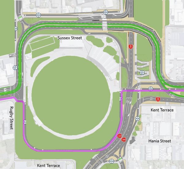
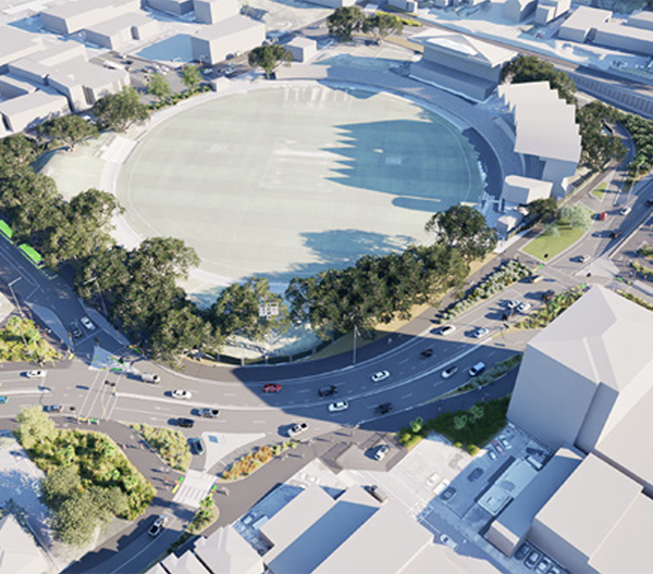
But I’ve drawn the lines round the other way, based on the visuals that LGWM published last week (bottom two images on this post: http://eyeofthefish.org/new-transport-solutions/ ), where there was the possibility of the SH1 route going up the hill towards Arras tunnel, but they showed no sign at all of Sussex St. Unless they have forgotten about it, it should be going over the top of the SH1, but as it is not visible, then perhaps they are planning it going under?
The biggest hurdle to putting the entire route into an enlarged Arras tunnel appeared to be the brick culvert drain down through Pukeahu Park / Tory St, which was in the way of the tunnel, and which they had to carefully dig around. I find it hard to believe that a brick tunnel 2m high and dug over 150 years ago about 5m below ground level, could still be the major stumbling block to the success or failure of a modern Public Transit system in the modern day, but apparently it is a bit of an issue. Still – I’m sure they can solve it.
Cuba St etc I will tackle after this long weekend. Was going to publish it today but it is harder than I thought!
Actually, thinking about it, they have probably only shown the Yellow SH1 going one way. They haven’t factored in the opposing route coming the other way yet…
@Leviathan There is no political bravery to overturn the car domination. The short section of Tory that was partially turned over to other uses was quickly returned to cars when a few local businesses and people complained about it. Did WCC even ask all the other people that use the street before returning it to the former state?
Cuba Street has not been extended despite the clear success of the pedestrianised section. The new(ish) lower Cuba street is supposed to be a ‘shared space’ but in reality is a status quo street that replaced Manners because someone decided cars still need to drive and park down there, despite being a key pedestrian area.
LGWM could first of all be a rapid intervention that removes on-street car parking, gives more space to pedestrians and bicycles/scooters and provides for bus priority on existing frequent routes but instead we’ll wait 10 years for all the business cases for the light rail and duplicate Terrace and Mt Victoria tunnels before anything starts.
Ben, you’re 100% right that car domination will spoil everything – but I have confidence that this will change. Don’t hold your breath, but the dinosaurs like Laidlaw are slowly dying off. LGWM is clearly incompetent and impotent, with no juice in its cohones to really effect change. They need someone with fire in their belly and a swagger in their step, with the guts to tread on toes and do what is right despite the nimbys. That’s not Lester, by the way.
Somebody like Maximus (whoever he was / wherever she has gone) would have been good. Alas, blown away with the wind… speaking of Maximus, and in case Stuart is still reading, here is a link to a post that Max wrote way back, on the subject of trenching Vivian St. http://eyeofthefish.org/trenching-vivian/ Might be relevant to getting Karo under Cuba St?