As noted yesterday, there is also to be a SHA for Kilbirnie. Here it is:
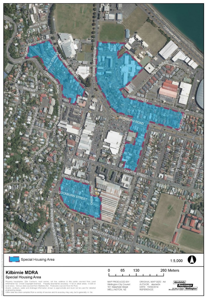
Now, can anybody tell me why that is the shape it is? Aren’t those the Council flats (top right)? And what is with the big area near the bus barns at the bottom? I’m really at a loss as to why these shapes have been chosen.
Here is another area: further north – in fact, almost in Thorndon. Have a look:
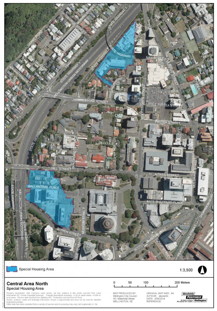
Now that’s got me even more flummoxed. Why have THESE areas been chosen? Forgive me if i’m wrong, but isn’t the one to the north slicing through an existing Government building? What the …?
Tomorrow – more crazy sites, in the inner city….



Max, you’re right about the Government building. They’re redeveloping it in the near future but it will be exactly the same footprint. Which begs the question – WTF?!?!
And the southern site on the Central Area North map is partly newish housing on Ballantrae Place, partly government-occupied office blocks and car park on Bowen Street.
Very odd!
Bad form to respond to one’s own post, but I’ve just found the WCC committee paper at http://wellington.govt.nz/~/media/your-council/meetings/Committees/Governance-Finance-and-Planning/2014/08/20140827-GFP-Agenda.pdf.
Comparing the map above and the one on p32 of the paper, the Central Area North proposals have been reduced significantly – such obvious targets for housing development as Old St Paul’s, most of the Court of Appeal and the National Library, Sacred Heart Cathedral, part of Thorndon New World, the Defence ministry (inc GCSB), the Justice ministry, The Thistle and the US Embassy have now been excluded. Phew.
Curioser and curioser!
Regarding the shape of the SHA in Kilbirnie, If you look at the current district plan map
http://wellington.govt.nz/~/media/your-council/plans-policies-and-bylaws/district-plan/volume03/files/v3map06.pdf
you will see the the SHA excludes all the land that is not currently zoned as a “suburban centre” ( The big hole in the middle of the SHA area, including the bus barn)
I’m guessing that the “suburban centre” zoning will already allow high density and easy development ( its got a big rest home in it already) so that is what it is not needing to be included in the Kilbirnie SHA.
Totally in Thorndon (Thorndon sits on both side of the motorway), and right through the William Clayton Building (the first base-isolated office building – ever!), which is about to be extended out and up. The Crown has signed a long term office lease for this building, for the Ministry of Health, so the SHA here is completely pointless and those behind it are just a little bit stupid.
I wouldn’t have an apartment in the Bowen State Building and William Fergusson Building (behind parliament). *deathtrap*
So, I’m still trying to make sense of this. There is someone with a property in Portland Crescent, according to the plan above, who has a tree lined driveway or back yard. Somehow, they have got on the Council’s black books, or maybe they’re on the Council’s good books – I really can’t tell. The properties on either side aren’t in the blue SHA zone – although several government buildings and even a motorway on ramp are covered. That’s one helluva curious boundary.
Hi Max
I am inclined to think the Housing Accord
will make minimal difference. If you had
heard the debate about the concept of an Accord
you would have heard a lot of cynicism from
Councillors. I think it is Government wanting to
be seen to be doing something about housing
supply.
Regarding the areas selected they are basically
areas already identified in our Urban Development
Strategy and associated policies, and District
Plan. Kilbirnie looks like it does because as Greenwelly
Says, the area in between is indeed Centre and higher
Density development is already provided for.
The comments about Thorndon are also spot on. Iona
And I persuaded Councillors to remove most of the officer
Proposed area (I would have taken the lot out because the
Rnant is so small) because it is already occupied by activities
That are not remotely likely to turn into housing. This included
3 embassies, schools and colleges, Catholic cathedral related
Buildings, New World, and a whole bunch of Government
Department occupied buildings. The proposal in that area was
Non sensical and we said exactly that.
The rest will make a modest difference round the margins, but it
Is certainly no magic bullet for housing supply.
Hope that helps
Warmest regards
Andy
Maximus – Portland Cres – is that a heritage property perhaps?
Andy – thanks for the clarification, I think you might have just confirmed what most of us supected!
Bus garages in Kilbirnie have just been yellow stickered, according to Scoop:
http://wellington.scoop.co.nz/?p=70813
The property in Portland Cres is the site of the Correspondence School (I once worked there for a while). It is a three storey office block of two wings purpose-built for them in 1976, housing 300 – 400 staff. They aren’t going anywhere anytime soon.
m-d. – no, not heritage I don’t think – from memory it is a Ministry of Education building.
So, from what Clr Foster appears to be saying, this is a piece of puffery to keep Nick Smith’s visage in the paper around election time. These SHA have certainly been quite prominently received in Auckland, but down here in the capital they do seem to be a bit of a joke. Well, to be honest, Nick Smith is a bit of a joke as well, to me. He’s the minister of Conservation who encourages logging in the forests, yet creates more sanctuaries. He’s the minister who permits mining in conservation areas, yet carps on about saving them. He is the minister of Housing as well, but signs Accords like this which appear to be meaningless.