Since Scoop posted a top-secret document online, via Peter Dunn, I’ve been trying to make sense of what NZTA and the Mayors of our cities, are up to. In the end, i figured that the only way I could make sense of the discussion was to make my own maps. The lack of coordinated and articulate maps from NZTA is either deliberate, or by accident. If it is an accident, then it’s down to gross incompetence, and if it’s deliberate, then it’s simply a political desire to keep you/us in the dark. You can make your own mind up. If they won’t do it, and show us some maps, then I will.
So, here are some maps. Let’s start off with an easy one: where is Transmission Gully?
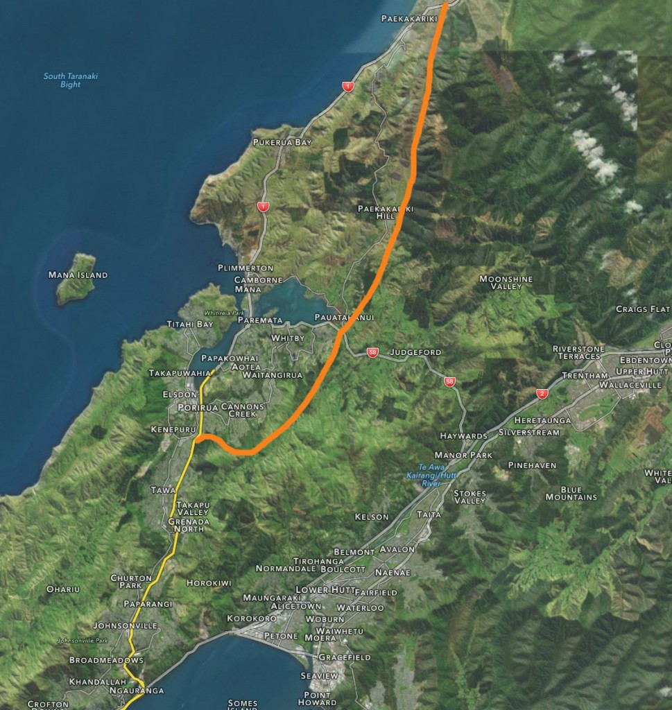
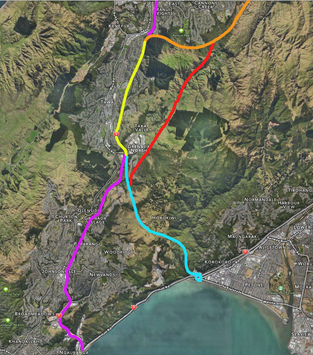
The road in orange is the approximate route of where it goes. (Correct me if I’m wrong). The orange route was carefully selected, after much, much discussion, in which it was agreed not to go down Takapu Valley, hence the hook as it comes off at Kenepuru.
The next picture is also relatively straight-forward. Green line shows the upgraded SH58 to Haywards Hill, while blue line shows the proposed Petone-to-Grenada “link road”.

Chances are that if you are travelling north, you will mostly choose to go via SH58 (green). Very few people from the Hutt will go south and over the blue route of P2G, unless they are working in Tawa or Porirua. At present (and if this link road was not to be built) they travel down to Ngauranga and take route SH1.
Let’s zoom in a bit more on that bit of link road.
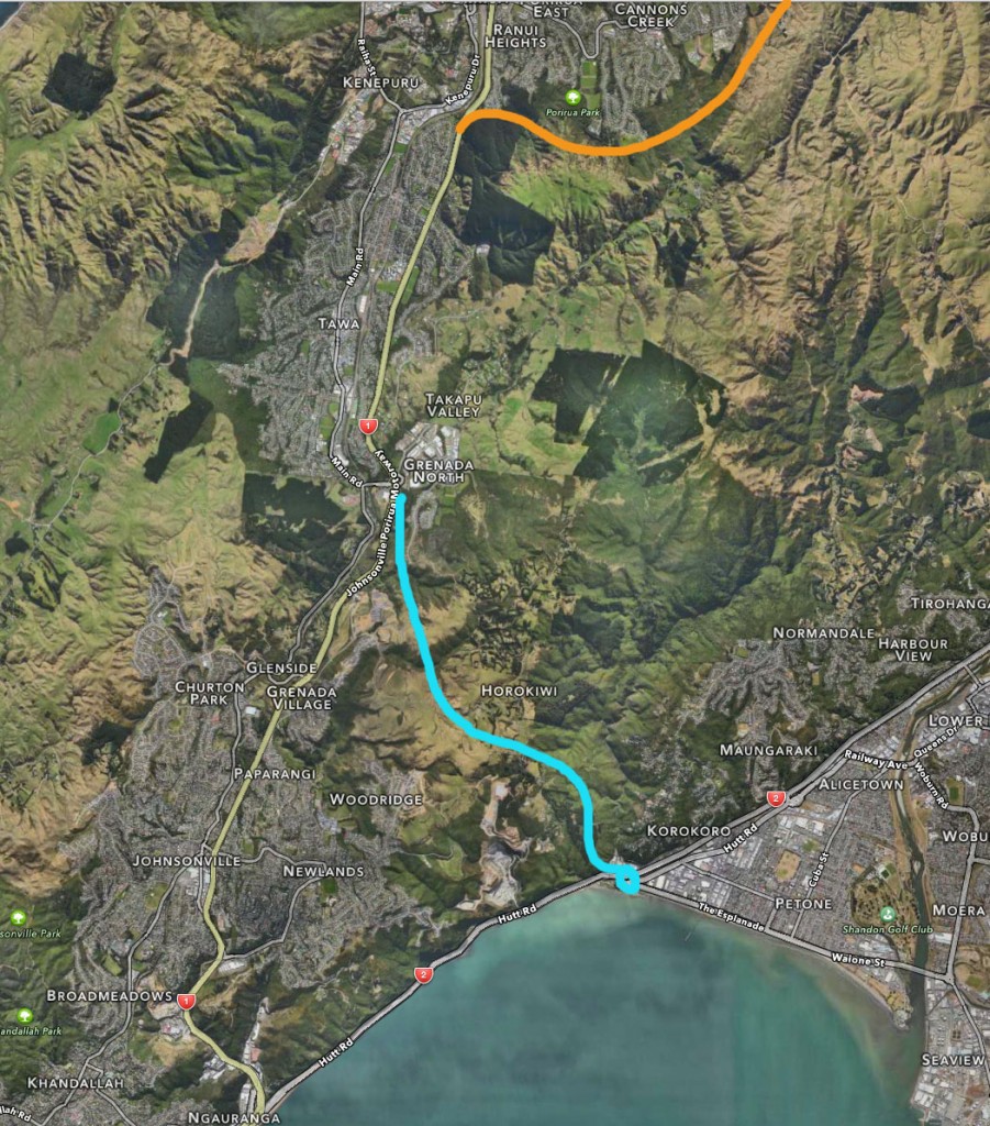
There’s a monster aerial roundabout at Petone, an arduous climb up the hill through Horokiwi, and then along the relatively flat-top hills to get to Grenada. Then it gets tricky.
This one here shows what it was going to do: beef up the road through Tawa (in yellow).

But then this announcement from the NZTA memo TP/03/29/02, means that they now really do want to go back on 20 years of negotiations, and bugger up Takapu Valley. The red line shows the route along the top of the properties in Takapu – not down the bottom of the valley, but cutting along the hill tops.
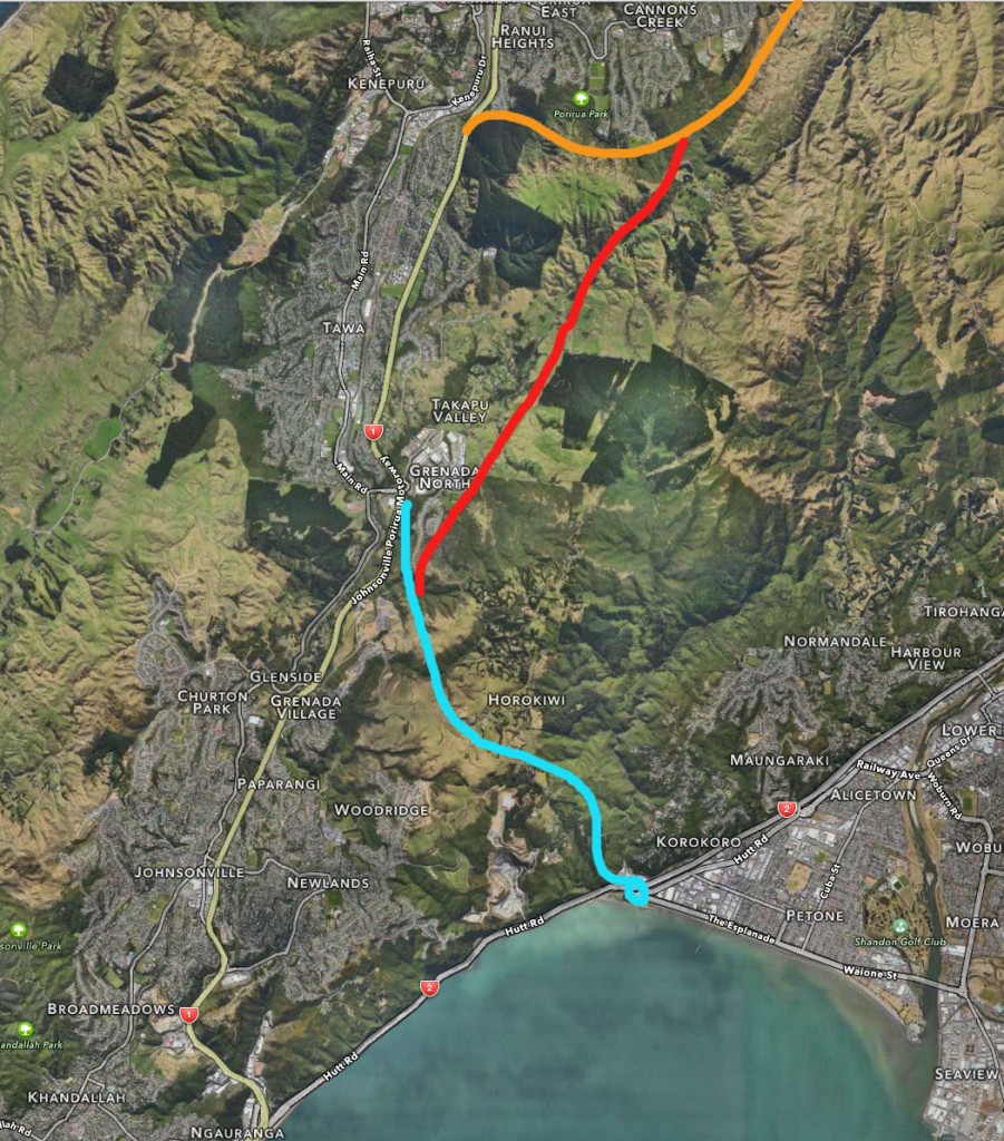
Well, it’s a blunt choice if you are the NZTA. Bugger up the lives of several families in Tawa if you beef up the Tawa route, or do the same thing to the lesser number of families in Takapu Valley. That’s just doing what a Transport Planner does – the key thing is the decision makers. While NZTA had promised to consult further with the community (after last year’s “consultation” in Tawa almost turned to fist-fights, apparently), instead they have done a secret deal with Mayors and CEOs of the Wellington region councils. Behind closed doors. That means Celia Wade-Brown, Ray Wallace, Nick Leggat, and Fran Wilde really, if I’m reading the tea-leaves correctly? It’s either a brave move by these leaders, or a very shifty one, as previously the Takapu route had been agreed to keep off the table.
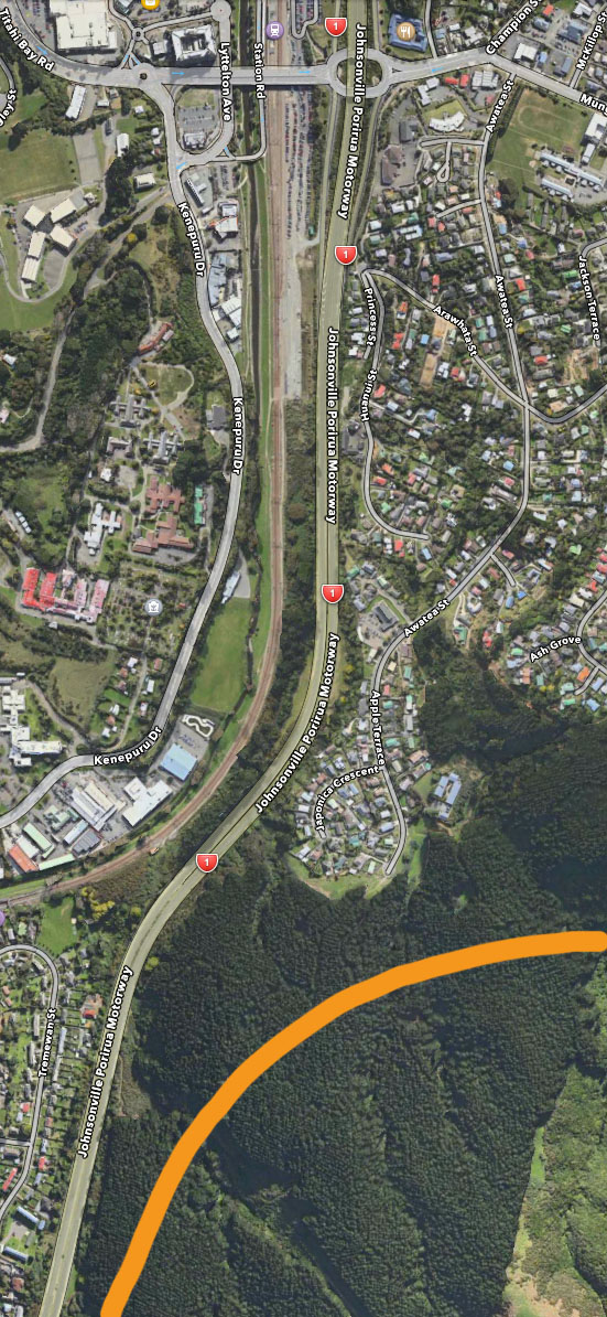
So lets look at what the alternative route, through Tawa, would mean. Here’s a group of 3 images that make up the route – before (ie existing / current).
_
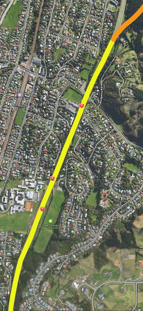
_
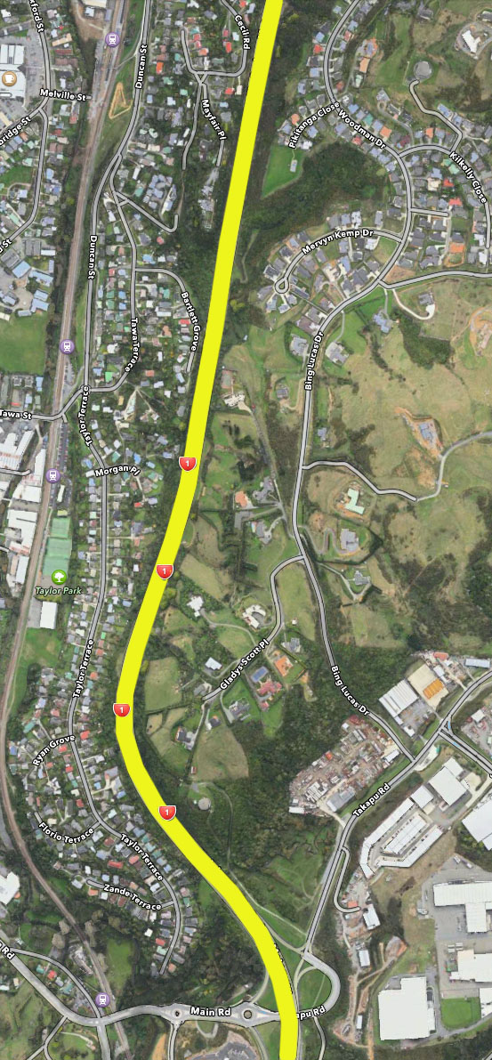
And now for the (now) proposed route through Tawa, ie with route widening and demolished houses. Basically, the route will double in width, from the current two lanes each way, to at least 3 lanes plus a shoulder each way. It’s hard to know exactly where the route is planned for, as no real drawings have been released, but it’s fairly easy to understand the NZTA logic – go down the side causing the least destruction to start with (ie through Tawa College sports field, rather than the houses on the other side of the road). It would end up like this:
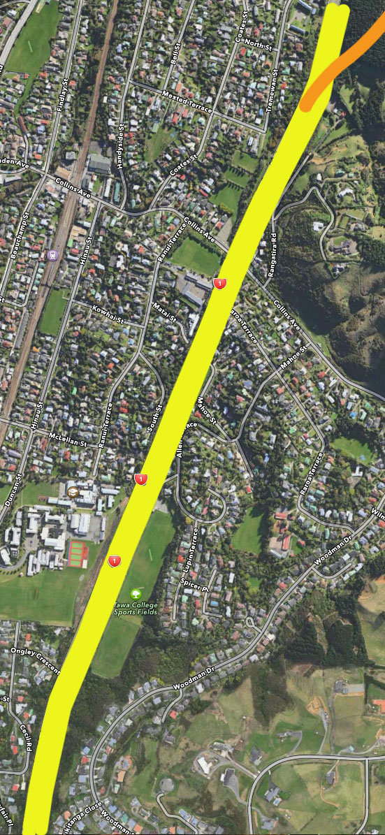
_
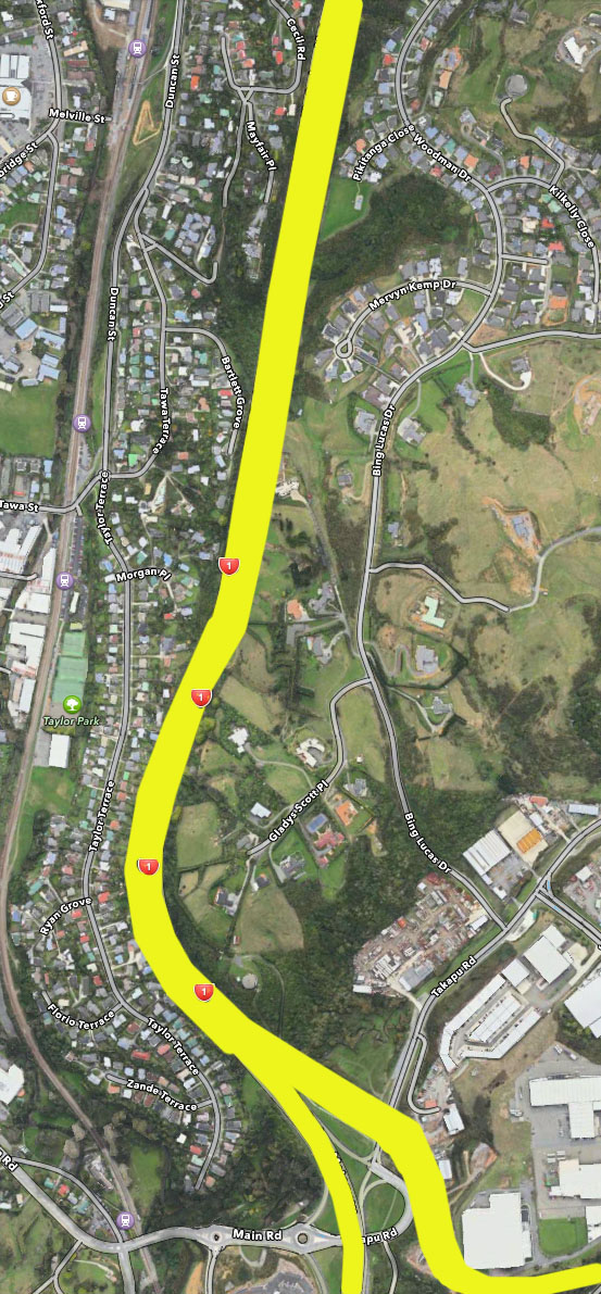
Exactly what happens at the Tawa / Grenada interchange, I can’t figure out, but its safe enough to say that there will be some kind of giant aerial or subterannean interchange, whether they end up going through Tawa, or flying off up Takapu Valley. The choice is yours – actually, its not yours, it is our Mayors, on our behalf, who will make this call next week. Destroy Takapu, or Destroy Tawa?



Even though I have had reason to drive up and down SH1 and SH2 a bit lately and seen the barely mobile parking lots across the median barrier this is horrifying. I know traffic planners have these Speerian fantasies, but that’s because without them they are no better than Parks & Recreation. Surely politicians take note when they are elected as an alternative to John Morrison?
Speerian tendencies aside, I’m trying to figure out how it is that the CEOs are running the Mayoral agendas. Isn’t it meant to be the other way around? I particularly dislike what sounds like: “we wanted Takapu Valley, we had a long hearing and were told we couldn’t have Takapu Valley, so now we are going to go ahead and do it anyway, with all decisions made behind closed doors.”
That stinks. Someone’s head should roll. Not just literally, but actually, physically.
Fran Wilde and the Regional Council are on record as opposing any new road thru Takapu Valley. The other councils ought to be following their lead. http://wellington.scoop.co.nz/?p=76083
Wonderful work. Actually there is no justification to sneakily double the length of Petone to Grenada Road and change it from an east-west link into a north-south road (Petone-Grenada-Takapu Valley-Judgeford). The most sensible solution is to go back to the triangle study that said make a high speed join onto SH1 near Churton Park off ramp. Wellington City Council and faceless unelected bureaucrats are using P2G as a Trojan horse road for the biggest green space loss in decades. It’s dirty stuff and the so called ‘green’ Wellington Mayor is complicit.
Simply build Petone to Grenada and connect with high speed join at Churton park as originally planned. Then wait to see what happens (heck traffic figures have been stable for 10yrs). Use the money saved to bolster Hayward’s (SH58) properly (not cripple it as they’re trying to do to force the Benefit ratio of P2G up as they’re doing now – roundabouts and 80km limit instead of dual landing before Trans Gully joins it).
The fact that the Parliamentary commissioner for the environment has once already protected Takapu Valley once from NZTA is telling. Why are we having this discussion again!!?
I don’t want to sound cynical, but Sir Ron Trotter was a strong opponent to the Transmission Valley route through Takapu Valley in the ’90s. Takapu Valley was protected by the Environment Commissioner then. Now NZTA are back building both!! And guess what, they’ve realigned it to smash right through Sir Ron’s living room this time. The house his family still inhabits. Call that vindictive? These hidden bureaucrats seem to hold long grudges!
When people are acting secretive, it means they have secrets. If the road is being worked on behind closed doors (despite their promises 8 months ago to have this all done in the open with public participation), then it means they have something to hide. And it’s probably not in the public interest.
How can we shine some sunlight on what is going on here? Who is pushing for a dirty deal?
Comparison with Tawa was just a straw man NZTA put up. The current width of the Tawa SH1 is wider than the stated width they need anyway. Remember it has a large green strip, and certainly wider than the current Aotea quay lanes there putting in right now. It just means that they need to modify drainage cambers, but there is plenty of room now, they just don’t want to. Instead, a whole new road has been dreamt up to traverse the rugged fault formed Takapu Valley? Also, its not a simple comparison of homes (which is about even in number) but also peoples lifestyles and properties and incomes in Takapu. Also the permanent loss of productive farmland and the complete destruction of a historic rural community. So house comparisons is like comparing apples and pears.
The name of the road (Petone to Grenada) doesn’t even reflect what it is anymore? The quiet Takapu Valley addition makes it Petone to Grenada to Judgeford. Buggered if anyone will use it when SH2 then SH58 Haywards hill is much flatter and straighter. Even travelling north from Wellington it would be better to go that way once Transmission Gully joins Judgeford. This is the wrong project NZTA/CEO’s, you should dual lnae SH58 fast. Unless of course there’s a secret reason behind the scenes as Stephen suggests for all the subdefuge?
Parliamentary Commissioner stopped this BS back in 1992. Why the heck are we back building both now. Traffic figures haven’t grown in 10+yrs. They don’t even need to widen SH1 past Tawa – it never bottlenecks there. Silly
You’re right to point to SH58 as the preferred route for the Hutt Valley, even though the NZTA call it a ‘red herring’. This is because of the inconvenient truth that once it is factored in it makes the P-G not viable.
The thing is, a previous survey done without an agenda in 1999, estimated that SH58 would see an increase of 46% and said that it would improving to take both the extra traffic and make it safer. This represents about an extra 7,000 cars a day. A reasonable assertion, given the industry and activity in the Hutt Valley. The current crowd have it at only 100 extra cars a day!
So if that traffic is exiting at Judgeford, it isn’t travelling through Tawa or round the bottom of the Ngauranga, and isn’t joining SH2 to Petone.
This means that with 7,000 vpd less through Tawa – no extra roading is required. Neither the road widening nor an extra road through Takapu Valley.
Or put it another way. The overall traffic in the region will need to increase by about 15% to get to where we are today on the Tawa stretch that is coping well.
It will also relive the SH2 Petone to Grenada section a bit as well (about 10% less).
So if NZTA want to set their keen brains and our millions to something to do with the roads – it should be improving SH58 and making a proper junction with SH2, and then designing non traffic light junctions on the rest of SH2 through the Hutt Valley. Job done.
I wonder what’s really behind the NZTA wanting to take the Takapu Valley. The widening of SH1 was obviously put up as a straw man to be knocked down and start a bun fight between the two bands of residents (C) and (D).
Why else when the road is wide enough anyway to put extra lanes on now by taking the hard shoulder – as they can when they want to (see SH1 in both directions at the SH2 interchange) – would they choose to draw the line on the map to make the maximum negative impact. Through lots of houses and school buildings – designed so that people point the finger and say – put it over there (Takapu Valley), and the NZTA say OK then.
I’m deeply suspicious of the motives behind a road that doesn’t make any sense on any level. Who’s to gain? We may find out one day.
You know, I can see (on paper) why the simple-minded might think that a Takapu Valley route might be a good idea. It’s cos it looks straight. The red line links directly to the orange line. There’s no doubt some thought going on in their heads that a straight line is preferable to a line with a slightly backwards / sideways wiggle in it (if you follow the yellow line to the orange line).
But that ignores the fact that the current SH1 yellow line route already has built-in areas for widening. Sure, it would in some senses be easier to work unobstructed on a brand new designation up an almost deserted valley, than to have to carefully carve out extra lanes alongside schools in Tawa, but the point is that they are already sitting there ready for it. Have a look at those close-up maps above – there is a long thin blank strip next to Tawa College, which is unused hillside (currently mowed), kept blank and empty for the sake of future road widening. Indeed, the only areas of human in habitation I see being affected are Raroa Tce and Allen Tce, as places like Mahoe St already have a set back from the highway.
By comparison, putting a new road high up through Takapu Valley is going to be a monster of a job, as well as one that has been thoroughly looked at and rejected over a decade or two ago. Why do this, other than to really piss people off? If you want to pick a war, NZTA, this is the way to do it.
You’re right Levi. The road is currently wide enough to take extra lanes right now without having to do a thing – by taking the hard shoulder as a lane. The NZTA can do it if they have a mind to it as they have proven a few kms futher south just south of Nguaranga. They’ve done the same on the M25 round London where they’ve run out of width – with far higher traffic volume, and installed ‘refuges’ – effectively long laybys for breakdowns between bridges and things that they don’t want to move.
So, it’s not extra capacity they are really after, because that could be done without any tears. It’s Takapu Valley.
I don’t think it’s strategic either, because even by the NZTA’s warped figures and faultless model (yeh right), destroying a whole valley and community only yields a gain of 30 seconds.
I reckon it’s more to do with finding a home for the 8 million cubic metres of rock they are going to extra when they destroy Horokiwi. Remember T-G has a surplus too of a million or two. Not much when you say it quickly, but that 8 million from Horokiwi cutting represents 20,000,000 tonnes. That’s about a million lorry movements. It can’t go far. As someone else has pointed out it’s a block of stone 1 metre high, 4m wide, stretching all the way from Bluff to Cape Reinga. That’s a big cycleway.
No I reckon they’ve invented reasons for sticking a road up Takapu, and it’ll be a spoil tip linking P-G with Transmission Gulley. Oh and now it’s all nice and flat we can stick some houses on it.
There are knock-on effects. If they fill Takapu Valley up with Horokiwi spoil, and then plonk a road on it, and then “open it up for development” (and since when are they allowed to use the Public Works Act to take land for commercial development?), that basically buggers any attempt to restore Porirua Stream or the Onepoto arm of Porirua harbour. Takapu’s really the last place left for the native fish and eels and all the little invertebrates to come from. The rest of the catchment’s been built over already.
Lets hope the elected officials do whats right for the community, area, the environment and the long term vision, rather than the un-elected CEO’s who’ve been locked in the tent too long with the NZTA, inhaling, – and come out believing the BS they’ve been fed.
It’s dead simple guys. Go back to the original plan Connect Transmission Gulley at Linden. Fix up SH58, SH2 (remove lights and widen between Petone & Ngauranga, and improve it’s junction with SH1), P – G will not honestly yield all the benefits attributed to it. You don’t need more north south capacity through Tawa as SH58 will be carrying the Hutt traffic and will be minus this voolume, you won’t need to find a place to dump the rock (Takapu Valley), we can all live in peace. Job done.
I can’t remember if the CEO of Porirua was one of the ones voting for the Takapu Road motorway.
If that person did – do they realise that they are signing up for a Porirua by-pass?
Once on at Petone, the flow of traffic will be to sweep you from the Hutt to Paraparaumu.
Not very clever.
The answer to wellingtons transport problems is the utilisise existing motorways and the easements that exist and to use them to the full capcity that they are designed for. if they were used as they were designed by professionals they will hence protect peoples homes and ecomony generally. welling is a arrow head at the bottom of the north island, they only way to move logistics freight and people from there homes and work place is to have a very robust rail system. The Gwrc are moving towards as the understand teh dymanics of the issues in pleace. the rail system belween Kapaiti and wellington is a credit to them.
Railways Ange? That’s radical. That would bring NZ into line with the civilised western world trying to future proof itself and prepare itself for a life with less fossil fuels. Lets stick with the V8s and road transport and burn lots of gas. We love CO2 and mining. Never mind we are in the enviable position that we can generate most of our power (80%)that runs trains from renewable energy that lasts forever. We like to turn the clock back 50 years.
Who cares about 100%. It’s only a slogan. The environment is only a tool we can exploit and discard in the quest to make our backers rich.
No go for gold. Build motorways everywhere. We really don’t need an environment to pass onto our kids.
.
Bob and Tam. I don’t think there are any plans to actually fill up the Takapu valley with fill. From what I’ve seen of the plans (on display to public last year) the road cut would be across the top of the farms, high up, and nowhere down near the base of the valley itself. If you have any info to the contrary, could you please post a link, or pics?
This is the pic from this blog, showing the route proposed last year. Is it still the same?
http://eyeofthefish.org/wp-content/uploads/2014/02/TakapuValleyHilldesign.jpg
I travelled on the top deck of a bus into Wellington recently and with the extra height it is easy to see that the easements along the Twain section of the SH1 provide more than enough room for widening the motorway. If ofcourse extra capacity is needed along that section which I don’t believe it is
TAWA section that should be.
Brendan – you’re talking from a totally logical, non invested interest perspective. One our decision makers should be talking from. Of course you’re right – but I suspect there’s more to this than meets the eye, meaning development opportunities and local politicians trying to ingratiate themselves if ever the super city ever takes off.
GB. You could be right. SH1 is wide enough if it is required – but as we know it was only ever a straw man to get Tawa residents pointing towards the Takapu valley. A road through Takapu valley serves no strategic purpose at all – however it does look more like an access road to a re-zoned valley for development.
A new Churton Park down the last unspoilt valley in the Wellington Council area. A unique pristine environment turned over for cheek by jowl housing. A valley that was protected by the environment court last time, and I’m sure would be again if push comes to shove.
Ching ching (the sound of cash registers).
So, NZTA. If you’re going to carry out the madness of P – G, do it as is your whim to spend our million. Let this be your white elephant – but don’t complicate things by tacking on a new housing development that might a bridge too far. Build a proper motorway junction (B) so people don’t get stuck at a multitude of roundabouts and then watch as everyone in the Hutt Valley takes SH58 anyway.
Hugo, I think it just become a lot clearer since the Reg transport Cmte mtg on Monday. WCC have done a quiet deal with NZTA (to stay inside the tent: http://wellington.govt.nz/your-council/news/2013/12/wellington-city-and-nzta-to-sign-accord).
This means that NZTA are now forceably joining the destruction of Takapu Valley (so WCC can make a land grab) onto Petone to Grenada (the operative wording in the agreement is: ‘Ensure that transport and land use decisions are integrated’). The problem is it’s turning the Petone to Grenada Road from a nice clean regional priority into a dogs breakfast that will be neither fish nor fowl. In doing this they’ve rejected the most sensible option B – a fast merge at Churton Park to SH1, in favour of a massive and complex 4-5 roundabouts at Tawa to make this hybrid regional road / WCC land grab work.
It was telling in the threat that NZTA made to GWRC at the RTC hearing – if you don’t sign up to bulldozing Takapu Valley now, then funding for Petone to Grenada might be reviewed. Of course the corollary to this is that Takapu Valley destruction was halted by the Parliamentary Comm for the Env once before, and by NZTA/WCC coupling Takapu Valley to the P2G project they risk the whole lot being bogged in the consenting process. Several Councilors pointed this out to NZTA.
The sensible way would be to build Petone to Grenada first as planned (option B), see how it beds down, and then build Takapu Valley after that only if necessary. A lot could be lost otherwise
And I can’t understand what’s in it for NZTA to be saddled with this need to aid a WCC land grab? Especially since there’s widespread agreement to do the P2G bit.
The down side for NZTA is that Takapu Valley will become the albatross around their neck while trying to get P2G consent.
The risk is it becomes another Basin Reserve scenario and there will be questions asked by the the Minister of Transport about competence in the Wellington office.
They should build Petone to Grenada as option B (the simple fast merge plan south of Grenada) and wait and see how it beds down, and then reconsider Takapu at a later date. Its the only logical path and this is becoming clearer.
RS – I’ve not read anything about the results of the meeting, except for the WCC link you give above. But so I’m not sure if this was a meeting open to the public, or exactly what has been agreed. Certainly the MoU signed seems innocuous – the only mention i can see of P2G is:
“Investigate options to develop a link road between Petone to Grenada to improve the resilience and efficiency of the future transport network.”
That doesn’t mention Takapu Valley, or several large roundabouts in Tawa, so clearly you have access to more information than me. Can you point me in the direction of any more info? Email me at contact @ eyeofthefish . org if you wish.
I seem to be missing something here – what exactly is ‘unspoilt’ and ‘pristine’ about Takapu Valley’s completely artificial landscape? And why should rural dwellers be able to claim these qualities in support of not having a road through their backyard (which they have considerably more of), than suburbanites?
There are a number of other good reasons why Takapu Valley is less suited, and a number of others why it is better. But please, let’s ditch the waffle, lest we all think it is simply a bunch of lifestyler nimbys out there in the T-Valley rather than productive primary producers.
Just to say I am not aware of any Council ‘land grab’. That may possibly be in some people’s minds but it certainly is not policy.
The CEOs’ paper to the Regional Transport committee did note that one of the advantages they saw in a road through Takapu Valley is that it would open up land for development. I made the point in the debate that I personally see that as a disadvantage. Wellington’s great strength is its compactness and walkability. Sprawling car dependent development doesn’t really do us any favours for a multitude of reasons.
Finally what greenfields areas we have set aside have been subject to extensively consulted on planning exercises (The Northern Growth Management Plan). Takapu is something that’s just come out of the blue last year.
What we said at the RTC is that more information is needed, it would be good for councillors to actually visit the area, and that Councils need to determine their formal positions. So while a decision will be needed pretty soon from my perspective there are very much a range of options on the table of which Takapu is just one.
I hope that helps. Wellington Scoop is publishing an article by me on this tomorrow which I hope will help clarify things.
Kind regards
Cr Andy Foster
Chair – Transport and Urban Development
Wellington City
thanks Councilor Foster.
On behalf of “Broadlands”, whoever that is, I’m reposting a comment form the Scoop website, as he / she has put a lot of time and effort into it, and it deserves wider exposure – i think. Message follows:
Wouldn’t it be great to travel from Wellington to Petone then travel up another Gorge to Grenada which is longer than going up Ngauranga Gorge to Grenada then travel to Transmission Gully. Cool, not.
One may as well go up Ngauranga Gorge then join TG from SH1 a more direct route and shorter or along SH2 with all traffic lights removed and up SH58, even more direct and shorter again. Cool, yes.
Coming from Seaview up P2G then onto TG through Takapu Valley sounds great but wouldn’t be used if the Melling Link is built and the traffic lights taken out of SH2 to SH58 this route would be favoured because SH58 isn’t as steep as P2G and is a much shorter distance to travel.
A land grab by WCC has been mooted. The only land to be grabbed would be on the eastern side of the new road which is very steep, unsuitable for dwelling or industrial development and only useful for farming or Belmont Reserve.
Maybe Celia wants to add this land to the green open air space.
Maybe Landcorp will acquire the land for farming and further justify their recently built 1 plus million dollar shearing shed which NZTA paid for.
There are a couple of trig points on this eastern land. Who cares.
There will be maori and european burial and artifects found or destroyed during construction of this road just like on the Peka Peka link road. Who cares.
There are a number of springs which Takapu Valley residents obtain their water supply from but who cares.
There are profitable farms which this road would destroy but who cares.
Noise, light and overhead pollution for residents of both sides of the valley but who cares.
Cellphone towers would have to be erected to maintain cellphone coverage. Yay but not at the expense of a road over the back fence thank you.
Residents of Takapu Road might get town supply water. Yay, not. They don’t need it.
Residents may also get Fibre. Yay. But not at the expense of a road being built over the back fence thank you.
It wouldn’t eradicate the possum population but, who cares.
Imagine the road kill. Very tasty.
The road was mooted 25 years ago and wasn’t developed then for various reasons. Those reasons don’t apply now, apparently.
The fact that it would provide another route out of Wellington if needed after an earthquake or a similar event doesn’t stack up. It will not be required. Earth moving machinery, air and sea will come to the fore.
Horokiwi Road leads onto Belmont Road and comes out on SH58. This has been forgotten.
Also, there is a road through Ohariu Valley along the Western Hills of Tawa that goes through to Titahi Bay. This has also been forgotten.
The proposed roundabout at Tawa reminds me of Spaghetti Junction in Auckland. What a nightmare. Too much unnecessary roading for Tawa.
It doesn’t have to be this way. It will be too complicated and not time efficient. Tourist drivers will be bamboozled and create more accidents as happens there now anyway.
Wouldn’t it be ironic if NZTA staff are involved in accidents at Tawa Spaghetti Junction being what they designed.
It would be redesigned in no time i’m sure.
The current Stop sign at the Takapu Road SH1 roundabout now is treated as a Giveway by most. It is a STOP sign for a reason people. Please STOP before the Yellow line.
A welcome change would be a stop sign for Takapu Road residents at the Takapu Road and Jamaica Drive T intersection and a free turn to those going up Jamaica Drive. Similar to the Davidson Crescent and Victory Crescent T intersection in Tawa.
There has been new lighting installed on and around the current motorway roundabout. One would have thought because of the light installation that NZTA are doing option 3 which is, to do NOTHING but sadly this doesn’t appear to be true. What a waste of money installing these lights when they will have to be ripped out shortly. It reminds me of The Terrace in Wellington. One month it would be ripped up by Telecom and then reinstated then the following month it would be ripped up by Telstra Clear and then reinstated, just silly
So to conclude. The Takapu Valley new road just doesn’t fit in the overall picture. It just won’t be used once the Melling Link is built SH2 traffic lights removed and SH58 is upgraded. Oh, I forgot. The WCC want the land. Well, they can go and get stuffed. The residents won’t be a walked over and giving up that easily.
Come on NZTA stop treating us like Mushrooms, come out from the dark cupboard and into the reality of day light. The valley road and all those weird, silly roundabouts are just not needed. No back room deals are needed.
Looking into my crystal ball I can see another Basin d6ecision coming. Ha Ha
[…] NZTA roads explained […]