
“Standing on shaky ground, ever since you put me down…” sang the Temptations and it resonates deeply with people of Wellington. We all know that our isles are shaky, and our city has the potential to be shaky in the extreme, but what we perhaps don’t know is just how shaky our particular patch of dirt is beneath our own two feet. I’ve been doing a bit more looking into this – starting with this post we blogged on Tsunami and then I found this other study, on Wellington’s rocky substrate. It’s quite an eye-opener.
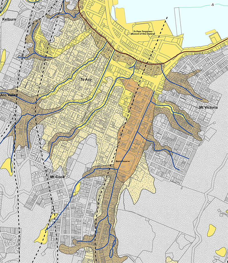
Obviously the WCC District Plan maps “seismic shaking zones” are based on these ground maps, and the maps are based on thousands of underground bores that have been drilled over the city. I can’t find the source document any more – if anyone knows what it is, please let me know so I can rightfully credit it. (Post-script: thanks to GK, the source document is noted as Semmens, S.; Perrin, N.D.; Dellow, G.D. 2010. It’s Our Fault – Geological and Geotechnical Characterisation of the Wellington Central Business District, GNS Science Consultancy Report 2010/176.)
Anyway, based on this info, the report’s authors have managed to make up a fairly good illustration of what is happening beneath the streets. And this has profound effects on where and how we might want to build in the city. For instance, I’ve long been under the impression that the growth areas were likely to be Te Aro, Newtown, and the part of Adelaide Road in between. I suspect the City Council have been feeling that way too, because they called that part of the Growth Spine.
But is this all going to come unstuck? The thing that stands out to me is just how poor the ground quality is along certain routes in the city, and logically the ground is poorer where there used to be a waterway. And waterways tend to run down the lowest points of the valley. And the biggest valley we have in Wellington extends all the way from what must have once been the boggy marshes of Newtown, down Adelaide Road, into and through the Basin (which was seriously proposed as the site for Wellington’s harbour in the very early maps), down Kent/Cambridge Terrace, and merrily splashing into the sea at what is now the Port Nicolson Yacht Club. Basically, there is still a watercourse there – there are brick culverts under the Basin with several species of fish living in them – and while its not quite the case of “a river runs through it”, there’s none-the-less a lot of water running under our streets. Especially down Adelaide Road and Kent Tce, but also: everywhere.
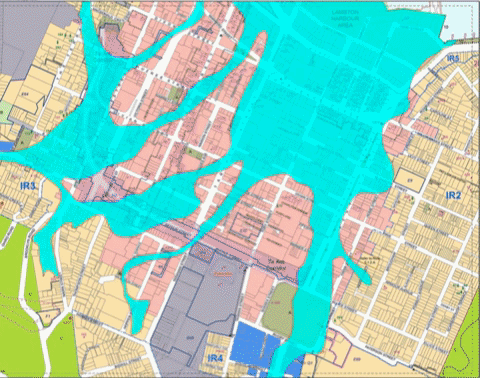
I thought it may be interesting to see how well the two maps coincide – the WCC ground shaking zones, and the GNS “It’s Our Fault” report on Wellington subsoil conditions – so we’ve made a Gif that morphs between one report to the other. What is interesting to me is that while there is close correlation between the two, they are definitely not the same. Close but no banana.
Actually, most of it has some close correlation – but in the region around Kent/Cambridge, the effects are far more widely spread. The WCC map (which I coloured in bright turquoise blue) is much narrower, while the GNS report is much wider. Both maps rightfully regard Courtenay Place as a right-off. That itself is something that Maximus wrote about way back in 2014 where Max noted the words of an early pakeha settler, who said in 1859: “Mr Plimmer also mentions that Te Aro flat was covered with fern and flax, except that portion of it extending from Courtenay Place to the Basin Reserve, which was one impassable bog. A friend told the writer that in 1859 he would walk out of the back door of the house in Courtenay Place – walk a few paces, then jump up and down and watch the jelly like movement of the ground for a considerable distance around.”
From the Cyclopedia NZ vol 1, p245
Don’t know about you, but that send a few shivers up and down my growth spine – Max went on to write, in his own descriptive manner:
“Just imagine – the very site that the writer was describing back then, could be the very site of Boogie Wonderland today. Those same tendencies still exist in Courtenay Place today – walk a few paces, jump up and down, and watch the jelly ripple… But we’re talking about a different seismic event. Nowadays, it’s dance party central, and the ripples are the waves of muscle, flesh, and sub-visceral fat that permeate the bodies of the young groovers who shake their booty on the dance floor. So, there may well be historic reasons why high-rise building has not taken place much on the Te Aro foreshore until today…”
“In 1853 Te Aro swamp burst through the narrow bank which separated it from the sea. The bursting caused a loud noise, which was heard from a considerable distance, and covered the town acres in the waterfront.
Te Aro flat was merely flax bushes, fern and streams, where inungas and eels could with very little skill be easily captured, and where cattle that had been pushed overboard in batches from the ships near the waterfront of Bethune and Hunter’s and other places on the beach, sometimes took charge of the town and defied the efforts of the bullock punchers in charge to pen them in the yards provided for them in the vicinity of Manners Street. Numbers got bogged in the swamp, where those that could not be rescued by horsepower were left to perish. In 1855 the earthquake disintegrated the swamp, and small islands of flax and toi-toi were floating about the harbour and interfering with the passage of small coasters in the area. At the same time the whole area was raised.”P304.
From Early Wellington – By Louis E Ward.
“Strange to think of Courtenay Place as a swamp full of eels and toi-toi only 150 years ago. We have all heard that Cambridge / Kent Tce was the route of the Waitangi Stream, but it is a bit disconcerting to read that the whole of downtown Te Aro was built on a 150 year old jelly / eel pie. Hmmmmm. Not so tasty after all. Looking at the new Elevate Tower Apartments that have just gone up 17 storeys high on the site of, what was, until recently, a sandy beach near Te Aro Pa, makes me nervous. Have the geo-tech engineers got it right? Have the pilers reached rock-bottom, in a very literal sense of the word? Fingers crossed.”

Piles on a building corner of Webb and Cuba went down 13m til they hit good ground, Likewise piling at the corner of Cuba and Karo Dr got piles down 11-15m to the solid
Te Aro flat seems to be composed mostly of the gunk that washed down off the hills
If anything the geotechs overbuild these days, under peer review everyone wants to stick their oar in and no-one gets criticised for making it a bit stronger
Contrast that with a two-storey villa a few doors up from the Mercure on the Terrace, I could get that place swaying by moving from side to side in the upstairs room
The only reason that place hasn’t fallen down is it’s on a bit of rock
Keep your insurance up, people
If I could find the original report, the cross sections through Wellington are very telling indeed. “Gunk that washed off the hills” is a very accurate description… The new tower going up on the corner of Taranaki and Frederick St has piles going down… for ever. Bottom driven percussion piles – repeatedly smashing the ground and driving the neighbourhood mad. Have you seen that project 60 MPa? It’s total madness.
Never done bottom driven percussion piles but have heard of them
Sounds bloody loud
Smacking a whole bunch of dirt is difficult to do in a, er, quiet manner
In other news, sad to hear of Wi Tui’s passing recently, a legend amongst crane drivers around town
I’m curious about what happened when they pounded the ground to build Te Papa. Presumably they created a hole with a very firm bottom, then filled it up again with something before installing the base isolators (there is certainly no basement in the building). Is the result a little island of solidity in a sea of blancmange? What does that look like in a decent quake?
I’ll tell you what it looks like. An upside-down cheese cake is the best simile I can think of. A thin crusty bit of biscuity base at the top, and then all the wobbly creamy cheesy stuff below. No basement in the building – and noting on ground floor, so that when the tsunami comes, it can sweep right through with little impediment. The base isolators mediate between the biscuit and the building.
But an upside down cheese cake is better than one that is the right way up! Except if you plan to eat it, of course…
There’s a really bad 90s video on the soil compaction at TePapa here
https://youtu.be/GL5wEicECto
I think from memory it was ringed in Sheet piling before they began the compaction, – not sure if they have left that in place or not- I suspect they have…
Thanks for that link Greenwelly – hadn’t seen it before, although I’ve heard the figure of 50,000 “dynamic compactions” before! Must have been horrendous for Wellington to have to listen to all that…
I am sooooo glad that I was not around for that compaction – sounds like it was hideous for the whole city !
I was 150 metres away. We got Te Papa to put sensors on the John Chambers Building to measure the effect. When they showed the whole building was tipping gently to the east the engineers starting muttering about how the equipment must be faulty…
Ha ! Yes, you were probably the closest place to Te Papa at that stage – and would have felt the effects the worst. I’m not surprised that the entire ground plane started to sink north-east into the sea….
Map is from:
Semmens, S.; Perrin, N.D.; Dellow, G.D. 2010. It’s Our Fault –
Geological and Geotechnical Characterisation of the Wellington
Central Business District, GNS Science Consultancy Report
2010/176.
There’s now an updated version (more boreholes, LiDAR surface model, newly confirmed active fault in harbour,…):
Kaiser AE, Hill MP, Wotherspoon L, Bourguignon S, Bruce ZR,
Morgenstern R, Giallini S. 2019. Updated 3D basin model and NZS
1170.5 subsoil class and site period maps for the Wellington CBD:
Project 2017-GNS-03-NHRP. Lower Hutt (NZ): GNS Science. Consultancy Report 2019/01.
Should be able to find both reports by Googling titles (would link but phone is being uncooperative with pdf links).
Fantastic, thank you GK.
Looking through the GNS Science website – these folk have been busy! So much work – so many publications – some amazing results! If you are interested, look also at:
http://db.nzsee.org.nz/2011/007.pdf
NZS 1170.5:2004 site subsoil classification of Wellington City
and
http://db.nzsee.org.nz/2010/Paper22.pdf
Site class determinations (NZS 1170.5) in Wellington using borehole data and microtremor techniques
but the full report referenced above is available at:
https://www.gns.cri.nz/Home/IOF/It-s-Our-Fault/Publications/Effects-Phase
and then click the 8th link down – just above the title: Earthquake ground motion modelling of local site effects