What do these names have in common? Why does Wellington have a potential problem? Why is it that I have to solve this basic problem for the city, yet again? Isn’t there a simple answer, staring us right in the face?
Our great city is built upon rock. Well, at least the hills are rock, while most of the city is built on the flat, from reclaimed land, but let’s stay on topic here: today we’re going to be in the School of Rock.
Apparently, our city has a problem – not enough rock. Rock in a hard place. Rock halfway up our main entry channel. Too much rock in Petone to build a road to Grenada. Why the hell is it called Grenada anyway? Did someone have a Spanish fetish? Or a Coronation Street fetish?
We have two quarries that I know of, in our city of rock. We have the Kiwi Point Quarry, which i believe is stuck halfway up Ngauranga Gorge, next to a meat works. And then we have Horokiwi Quarry, which is along the road a bit, further north, stuck with an impossible turnoff from the main highway to the Hutt. Neither of them are really very well located for anything other than trucks going straight out onto the roads – which in the case of a quarry, is perfect.
But Kiwi Point want to expand, and want to eat up another hillside to make more rock. I’ve no great objection to that, but some people are complaining that we will have a “wall of rock” visible as Wellington’s main entry point for the next 40 years. Again – I have no objection to seeing a great wall of rock, although I do like a good ravine.
And then we have Horokiwi Quarry, which I guess supplies rock mainly to the Hutt region, as their road access means that they can only drive north. Horokiwi is an area that is home not just to the quarry however, but also home to a small community of people, mainly on lifestyle blocks and small farmlets. The quarry is literally at their doorstep, and is both their gatekeeper and their jailor. The quarry must surely be limited by its location – for noise and dust as well as possible future expansion.
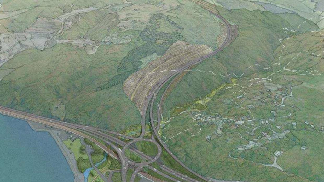
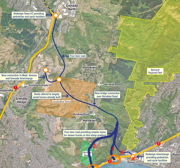
Lastly, we have the planned (and recently canned) “much needed” link road between the Hutt (Petone) and Porirua/Tawa (Grenada). It has been canned because it was going to be the most expensive road ever built on this planet, or something like that. It would involve taking vast amounts of rock away, an amount so vast that they would have to find a use for it, like extend an airport, or fill in Karori, or add another 5m width to the Hutt Highway and call it a cycle path.
But here’s an answer, offered free to the city and to the region. And free to NZTA too – I’m nothing if not generous. It is a starter for ten – you sort out the details.
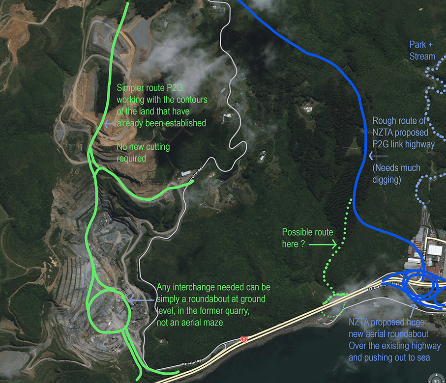
Combine those things. Either route the new P2G road through the existing Horokiwi quarry, and move them to a new site on some nearby rock. That way, a hole has already been dug, which NZTA could then build a P2G road through. Some re-profiling needed. The intersection with Petone then takes place 200m further south than is planned at present.
Or option two – tell Kiwi Point Quarry owners that they have a license to dig for more rock, but not in Ngauranga. On the route of P2G instead. In return for them digging out a route of 8 million cu m3 of rock to make the route, they can have a hillside north of Horokiwi to dig away to their hearts delight for the next 100 years.
See? Simple!

Thanks Levi
P2G never looked like a $250 million road because of the huge volume of rock and soil proposed to be moved.
Some of the early route thoughts did go in the vicinity of / through Horokiwi quarry. One of the main concerns for me about P2G was the thought of cutting a huge hole in the harbour escarpment. The picture you show of going up via the Korokoro stream gully would be awful for what is currently a really lovely part of the Belmont Regional Park.
Rethinking the road so that it is not designed as a 100kph road (and therefore straight and with large cuts) seems to me to be the way to go if a road is to be built here. (ie work more with the landscape rather than carve it to pieces).
One other ‘rocky’ point to make is that all rock is not the same. Kiwi Point quarry has a lot of the higher grade ‘blue’ stone which is evidently harder wearing (important for roads and buildings etc) than the more common (as I understand it) ‘brown’ rock.
I will very much look forward to your upcoming thoughts on Shelly Bay !!!
Meanwhile enjoy the weekend (and the rest of Friday).
Kind regards
Andy
Thanks Andy, useful comments to have. Totally agree about the slower speed limit on the P2G road – although I’m not quite sure where you mean by the Korokoro Stream, as it does not show up on my map. There is a stream that comes out in Cornish St in Petone (Ulrich Aluminium) is that the Korokoro stream? Thats the bit of ground that NZTA want to blow away, not me. Disused quarries are my kind of thing.
Re the rock colour, I totally get you and I am NOT a geologist, but there is a very slight chance that I may be right on this: the brown rock is more weathered and near the surface perhaps, while the blue rock is deeper underground? Did I get that right? Or maybe I got it arse about face, in which case I should totally go and get a job with NZTA….
There are quarries further north in the Hutt, by the way. Right on that really awful dogleg of SH58 by the SH2 intersection, with all the blind corners. So use that to reroute SH58 and make it safer, and no new roads needed at all.
Well yes, you would think that the Hutt would be happy to use SH58, but apparently not. The Mayor of the Upper Hutt seems to think. it will be a calamity…
Anyway – I’ve just added a closer-up map / plan. Does this work any better?
I don’t know enough about any of this to know whether it matters, but the quarry area is full of surprisingly large quicksand pools currently. I’m not sure what if anything that implies about the geology.
Thanks Michael – Is it really quicksand? Like, suck you under in 10 seconds quicksand? – I’m pretty sure that the quicksand will only be a little, on top. Likely to be solid rock underneath – but how far down? Only one way to find out – jump in !
Here’s a link to Mayor Guppy:
https://www.stuff.co.nz/national/112201185/transmission-gully-motorway-could-be-bad-news-for-sh2-motorists-in-wake-of-project-delays
“The Government’s decision to shelve two major Hutt Valley roading projects has stoked fears that congestion will be even more unbearable next year once the Transmission Gully motorway floods State Highway 2 with thousands more vehicles.
“That is the view of Upper Hutt Mayor Wayne Guppy, who says New Zealand Transport Agency (NZTA) reports predict a 30 per cent increase in traffic on Hutt Valley highways once Transmission Gully is finished in 2020.”
“SH58 will become the defacto “gateway to the Hutt Valley” and congestion will impact negatively on the economic benefits that Transmission Gully should deliver, Guppy said.
————–
I dunno. Most places would love to become the Gateway, with all the. implied new growth. What’s up with Guppy ?
Honestly I don’t know, I just believed the scary warning signs and kept clear. I was in there slightly by accident and didn’t want to push my luck.
Enjoyed that Levi.
I still dream of using the quarry at Kaiwharawhara as the home of the much trumpeted stadium. Like the Eden Project did in a quarry, but on steroids.
Expandable rail link, motorway junction, nobody nearby to upset – and not swamping the city with traffic…..
its got it all going on!
Hi Levi – yes the Korokoro stream is the one that comes out at Cornish Street. Really lovely walk/run or mountain bike up into the Belmont Regional Park, or you can go up the stream and up to Horokiwi Ridge and even down into Tawa.
For the engineering minded there is also a water reservoir in the valley.
Well worth exploring.
Warmest regards
Andy