
So, finally today we had the news that we all knew was going to happen one day – that the Pink Council building (WCC’s CAB) is to be demolished and developers / visionaries are asked to submit bids and proposals for a replacement building and a Masterplan. After too many years of sitting round doing nothing, suddenly it is all go, and proposals are needed immediately.
I suspect that this means that in reality, work has been going on in the background, and you can be fairly sure that there will be one bid from Wellington’s favourite developer for the rich, Willis Bond, which probably also means there will be a link with Athfield Architects as well. There are bound to be some other bids as well, possibly one from Prime Properties, and maybe one from Mark D or Maurice C. Other property developers like Newcrest, or Argosy, or Precinct, I’m suspecting might want to wait this one out on the sidelines. Of the architects, everyone in town will want to have a crack, including me, but this is not an architectural competition, but a developer rumble, perhaps to see who has the deepest pockets. And I’m not in bed enough with developers to be in the running for anything.
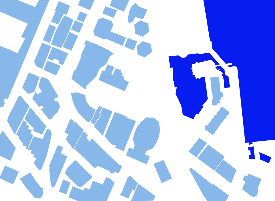
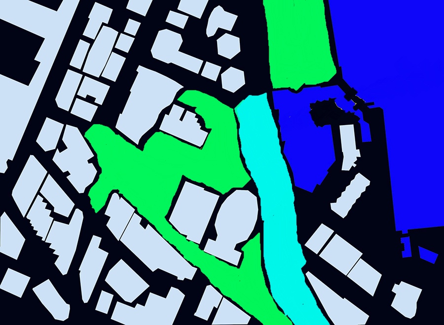
But before the new building will come the need for a new Masterplan, and we’ve touched on the need for this before, when we posted about Portals. There’s a figure-ground plan from that reproduced just above here, with the buildings in a delightful pale blue and open space in white. That’s the situation as it is. But before we limit ourselves to just a refurb on the current layout, we really to accept that things have changed forever, and perhaps we need to take the chance to look again, at exactly where the boundaries are. That’s what this other post (below) was about, noting that if you remove the CAB and maybe even the MOB, you could have a very different space to play with.
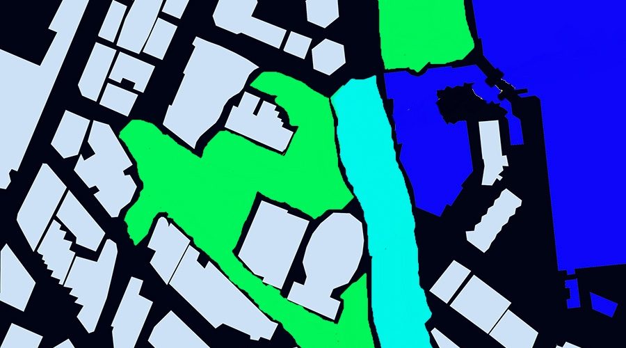
In a not-very sophisticated colouring package, we can show here what the possible extent of the new Te Ngakau square could be like – a larger square than we have at present, perhaps, a Ngakau Nui if you would (below). The green indicates potential extents of a revised Square heart to the City and the pale blue indicates a zone where we could / should / would think about the means of crossing the road, given that the City to Sea bridge is also nearing the end of its life.
I guess that my argument is that instead of just recreating what worked in the 1990s, now there is a chance to make something that will work for the 2030s onwards. Is a new building really what we need here to replace the CAB and MOB? What if we were to take a much bigger view? What if the walls to the new larger square were the existing buildings on the other side of Wakefield St? I’m not saying that ALL the areas in green or blue should be a Square, but they should certainly be included in a public space masterplan. And that masterplan needs to come up with a new answer to how to cross the road – the waterfront highway. Do we want another bridge to replace the existing delapidated messy City to Sea bridge? Do people like it because of the Para Matchett carvings up on the top? Should we demolish it and make a crossing at street level, like Chris Kelly suggested so many years ago?
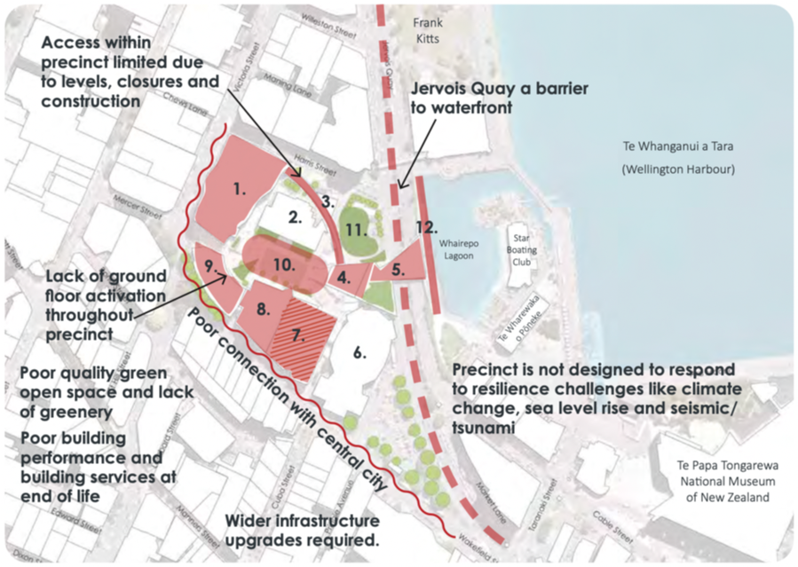
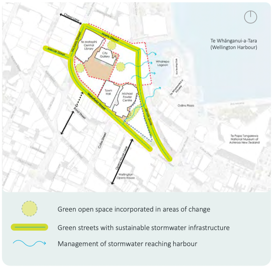
Back in 2021 the WCC commissioned a report on the Square, and it was / is an excellent resource. Produced by The Property Group, whoever they are, it has a really thorough examination of all the issues, and has some useful diagrams. You should go read it.
In the Report, they note the difficulties faced by the area (above) and the vehicle movements (below) and the pedestrian movements (also below). But also the Green Streets that surround the site. I’m hoping that this Masterplan stage will take a good hard look at what we have done / are doing to the city.
Let’s not rush this phase – let’s take a good hard long careful look at what we need to do. It would be helpful if LGWM had actually published a Masterplan before they were terminated, because I’m pretty sure that there was meant to be some Light Rail or Fast Bendy Buses around here, somewhere. But who knows where, now?
People of Wellington – are you with me?!!


Demolish the lot – MOB, CAB, and library, Fill with grass and paving and trees. And possibly the old Cuba Street floral clock if it’s still in storage.
Then rotate the old town hall 180 degrees so it opens onto the newly-created plaza.
And Bingo! A perfect setting for what’s shaping up to be Wellington’s first billion-dollar building
If the Council decide to lease the former Datacom buildings then there will be less immediate pressure to develop the CAB site. They need to consider pausing any development and to open it up as much needed greenspace. I’d prefer they put their efforts on the Civic Square rather than Courtney Place.
The Datacom buildings being those two corncobs down by the water? Yes, Courtenay Place and Lambton Quay seem like a lower priority at present. Pipes first!
Yes, the corncobs. The WCC actually own the land and are leasing it to the building owner. It makes sense for the WCC to be adjacent to and have some presence at the Civic Square but to reserve the prime spots for cultural/public functions or open space. Absolutely, fix the damn pipes but also we can’t lose sight of the fact that under investment of the existing infrastructure got us into the mess in the first place. What we shouldn’t do is build more cheap buildings that need to be torn down every 25-30 years.
Although, we now have the perverse situation that the council is spending million to extend office space on levels 4 and 5 to rent out commercially, while it is paying commercial rent in another building….
““We also agreed to a modest (880sq metre) extension to the Level 3 and 4 office space that sits above the library proper. This extension will be net positive in terms of revenue to Council”
https://wellington.govt.nz/news-and-events/news-and-information/our-wellington/2021/04/central-library-design-principles
I have to admit I’m as completely confused as the Council seem to be. The last I read, Levels 3/4 above the library was being taken by the VUW School of Music. Surely the WCC would function more efficiently if they were located in one building :D. I guess this is why you normally undertake a Masterplan BEFORE making these decisions.
https://www.rnz.co.nz/news/national/509118/plans-to-move-nz-school-of-music-to-central-wellington
nemo, In response to some of your intriguing observations/ideas. I agree that the Civic Square would benefit from subtracting rather than adding buildings and increasing usable greenspace. There are a few related decisions that will effect the success of a larger Civic Square though. Namely, the eventual decisions on the WCC offices location, bus priority and the Golden Mile. If the GM projects proceeds it’s more likely that local traffic will be channelled up Jervois Quay making it more unpleasant to cross at grade than it currently is. Buses may help but let’s face it, many ppl will continue to drive. I suspect the City to Sea bridge is popular because it has a view of the harbour, sun and is shielded from traffic noise somewhat. It’s one of the more successful spaces so I wouldn’t like to see it disappear entirely. However, I would like to see a more direct connection between the Civic Square and Frank Kitts Park/Waterfront. We’re a hilly city so I doubt that another set of stairs or a ramp will phase us.