
So far, it appears that the proposed new solution – the “final solution” – to the traffic woes of inner-city Wellington have not been that well received. Is this the only solution? What other ways have people / government departments tried to solve the dilemma of “Round the Basin” intractable traffic problems over the years? You could simply look here:

Above was the proposal from NZTA all those years ago, of Option A, as it was presented to the public and eventually, as it was also presented to the Basin Bridge Board of Enquiry. The SH1 west-bound sailed in the air for over 320m of glorious concrete on sculpted concrete legs, while below it young ladies sunbathed in acoustic quiet in teh middle of a traffic island (sorry, for those of you new to this subject – its an old joke, but one of which I never grow tired).
Below just down there was their other proposal, the one that no one ever too seriously. Option B, which was so bad and so hideous that no-one really ever took it seriously for more than 10 seconds. Yes, it pulled the highway out away from the Basin, but instead left the Grandstand Apartments looking forelorne and weirdly like a third stump on the Basin wickets (insert more suitable cricket analogy here if you wish).
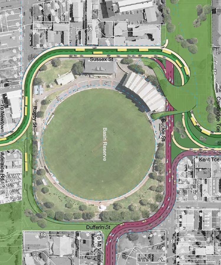
And digging around in the Eye of the Fish website, I unearthed these pictures of the famed Option X. This was of course the proposal from the Architectural Centre, which was very active in the first couple of decades of this century, and it shows the simple and obvious alternative to the NZTA scheme, of having the SH1 at ground level and a very small bridge on Sussex Street leaping over the SH1. The roading seems to work relatively simply – there is a lane from Kent Terrace that breaks off to go West on the SH1, but there is no corresponding lane peeling off SH1 to go north on Cambridge Terrace. I think the feeling was that motorists could simply go right at Taranaki St junction in order to get to Courtenay Place.
The other major feature that Arch Centre brought in was the ability to cross the whole area within a greened park. This involved a couple of swoopy green landscape elements from the top left into the Basin precinct, and then what I thought was the masterstroke of the design – the axing of one whole side of the Basin to another Park, so Dufferin Street was no more for cars, just for the feet of children after school.

Above is the close-up, below is the full monty. Just in case you had forgotten.

Above here we can see the full Option X plan and explanation, while below is the same thing, but oriented around to be the same way as what NZTA is offering now.
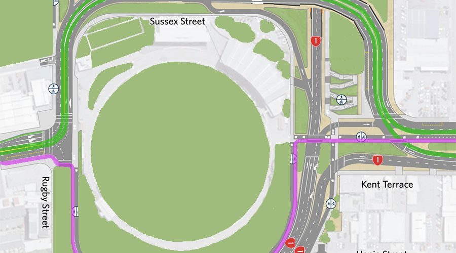
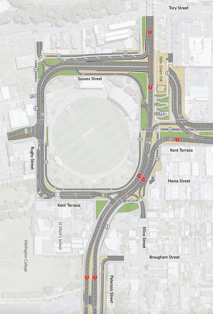
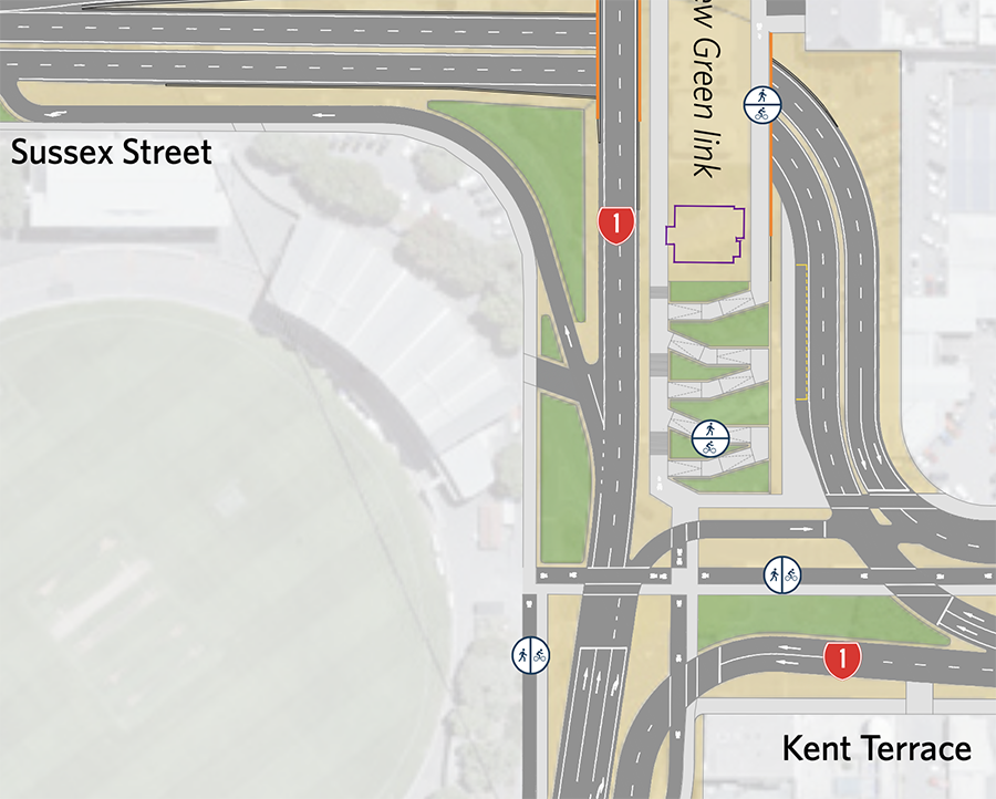
Just as a reminder, here is what NZTA (formerly Waka Kotahi) is offering us now. They’ve lost the scoria-coloured SH1 clarity, but here you can compare and contrast between Option X and the new NZTA. It needs a name – I’m going to call it Option Z seeign as it has a sort of swashbuckling Z for Zorro on the right, near the words New Green Link.
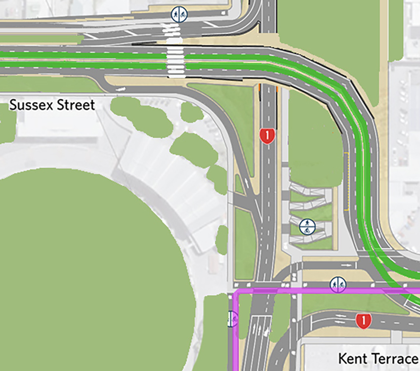
And below here is an altered graphic of what NZTA are offering us now, but altered enough to bring us some of the crucial elements that Option X proposed. You can see the purple link of the Cycle Way – seems legit – although it crosses the SH! and local roads several times on the North side (ie the Right Hand side of this picture). I’ve swapped the SH1 to go UNDER Sussex Street, teh same as what Arch Centre had, and also removed the road from near the Schools in the South-East corner, to bring back that Park proposal. But I’ve missed out the Green Swoop aspects to the North West, as somehow that just does not seem able to work.

Here we are zooming in a bit more, focussing in on that troublesome part of the Kent / Cambridge / Basin Junction. This area really just does not seem to work – there are about 9 sets of traffic lights visible in just this corner alone. There HAS to be a better way.
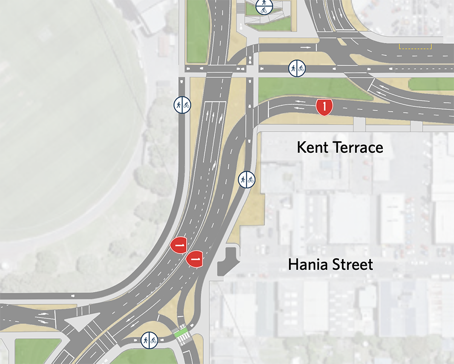
In this opposite corner (below) you can see the troublesome spot at the entrance to Government House and also, coincidentally, the entry to two or three or maybe even FOUR of Wellington’s Schools. I mean, who ever thought up this dumb idea – to have all the schools at that one corner – and then run the old GG through the middle. AS dumb as a basket full of badgers. One good thing that NZTA have proposed is to stop entry INTO this tiny Kent Terrace stub directly off the SH1, although bizarrely it seems that traffic can exit from there across some traffic lights, to enter SH1 traffic going either way.
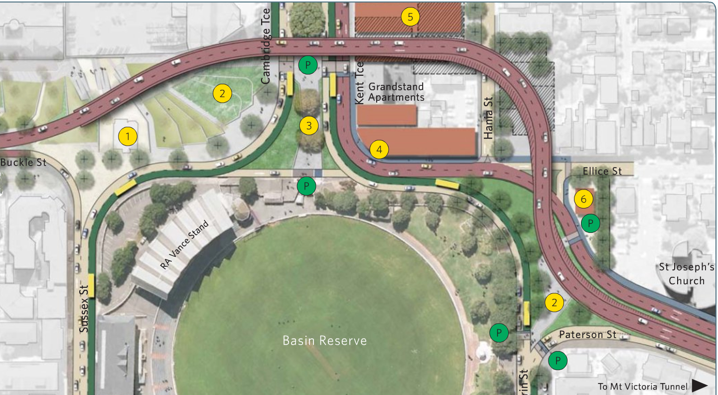
Let’s move on and have a look at Sussex Street a bit closer – it seems that they have left the Grandstands alone, but destroyed the housing to the West of the Basin. Seriously, this is not a problem to me, as it is incredibly ugly and some of the worst designed housing in the capital, which is a big claim, but there – I’ve said it. You’re ugly and your mother dresses you funny. Bad architecture should never be tolerated.
But also, why does the on ramp and the entry road behind the Grandstand have to be so bloody long? (see below). That’s a total of about 6 lanes there – NZTA has clearly never got the memo about trying to make Wellington a more pedestrian-friendly city. Also gone is the Marksman Motel and other buildings. That’s quite a swathe it is cutting out…
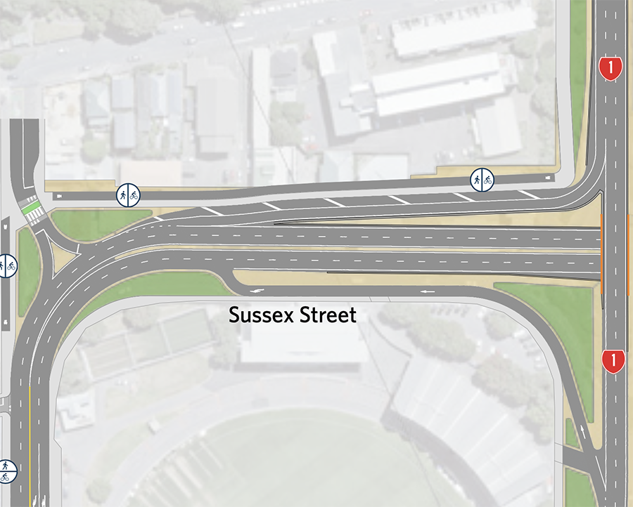
And lastly, for today at least, the troublesome route for SH1 that has to drive UP the hill in NZTA’s scheme, only to leap OVER Sussex Street and then go back DOWN again into the Arras tunnel. Does that make sense to you? Why do that? Is it just because of the Saint Auberge cottage?
NZTA Versus FISH


Am I right in assuming that the “Saint Auberge cottage” is that old brick thing that was left behind when St Pats fled to Kilbirnie?
Yes. Value to the Catholic community I gather, as Ms Auberge is destined for sainthood….
Thanks. And thanks also for the collection of graphics depicting the various options that have been considered over the years. That’s quite an important contribution.
Also known as the Home of Compassion creche,
It looks like it has been moved in the plans, but it was strengthened restored and moved during the Arras Tunnel construction anyway – So its pretty easy to shove around now, its sitting on the great big concrete pad..
https://www.youtube.com/watch?v=I9H7jJTOJME
https://nzta.govt.nz/assets/projects/memorial-park/docs/crhm-plan-appendices-8.1-8.5.pdf
As for the long drive on sussex st round the back of the RZ Vance stand, the reason is that the main roadway is going down a trench to go under SH!, so the only place it can meet level is ar the southern end…
Mother Aubert, please!
My apologies Betterbee, my knowledge of Catholic nomenclature is sorely lacking. But seeing as she was never married and never produced any children that we know of, why would she be called Mother? Makes no sense to me !!
To give you an idea of the terrain, I’ve made an image that shows the profiles with existing, over and under.
SH1 going over Buckle St sounds odd but would mean you can keep the Arras Tunnel unmodified. Going under will require a big rebuild on the eastern third of it, from my thinking (I’m not an engineer).
https://i.postimg.cc/JrS3p1Pm/basin-reserve-profiles.png
Thank you !! That’s brilliant.
Let me think.
There is another factor that NZTA will have factored in, but maybe people don’t know about. There is a large historic brick sewer or stormwater drain that crosses the front of the Arras Tunnel and then goes down Tory Street – built by laborers over 120 years ago. Cross section shaped like an egg. That was revealed as a limit on the designs of the Arras tunnel a dozen years ago, so NZTA were very keen not to disrupt this. It is very deep down in the ground, which might put it right in the way of any further tunnel.
Yes, part of the main sewer interceptor, isn’t it, between where it splits off at Taranaki St, and then rejoins out below the back of Government House?
Seamonkey – search me, I have no idea, but if it is going down Tory Street, wouldn’t it be heading for the sea near Waitangi Park? Not going into reverse and going back up the road to Government House?
Yeah the historic sewer is running on the East side and did dictate the profile. Going down any further would disturb it, but I don’t know who if it’s a deal breaker.
Some pretty interesting details in here:
https://www.waternz.org.nz/Attachment?Action=Download&Attachment_id=1827
Great link PPtD!
Indeed! How on earth did you find that ?! Great find Driver !
TBH, Given that we have a major cycle/walking connector running down the centre of Kent/Cambridge, the only way was can “solve” the Northern basin is to grade separate this from the Vehicle traffic,
So we could lift SH1 westbound in front of the basin, and push the cycles under, but that’s basically the Basin Bridge in drag and probably not going to fly,
That leaves raising the bikes, this is more helpful as you could also then have “limbs” off the bridge to travel over SH1 southbound and across to the “green link” … this would remove 3 sets of lights,
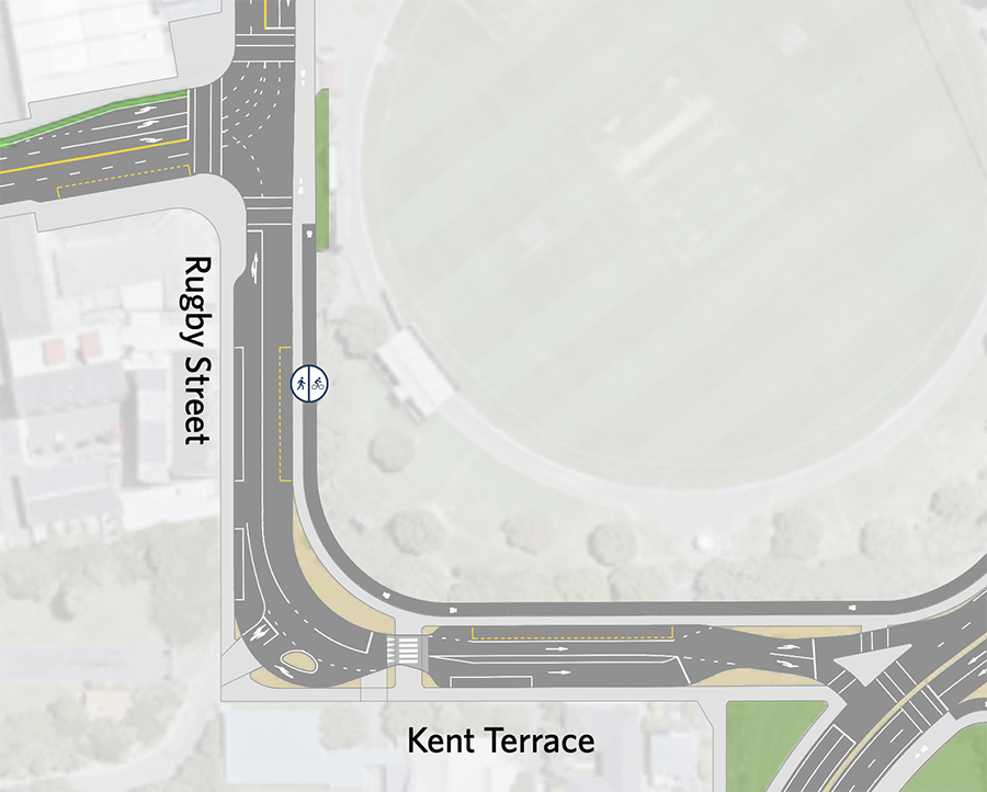
There is a bike/cycle bridge up to the netball courts, so the precedent in the plan exists,
Yes, having bikes ride Under the road is rather frowned upon these days – they smell, are full of graffitti and old men that smell of piss. Nasty things, underpasses. So, yes, by all means put bikes up on a sexy lightweight overbridge..!
I think it’s best to keep people and bikes at ground level, while trenching the traffic.
Yes, agreed, but you can’t put tunnels below ground round here, as there is a major amount of sub-surface water moving from the Basin down to the harbour. It is one of the key old waterways of Wellington, and is still running, particularly in high rainfall. So, NO tunnels below the street level of Kent Terrace. No ifs or buts – you just can’t.
I wonder how long it’s going to take to cycle from Adelaide rd to Cambridge tce. That’s a lot of lights. Anyone able to estimate a time?
I imagine that many cyclists are going to give up and use Tory st instead.
If the “drop in” sessions were more convenient I would have certainly asked what modelling they had done on the expected time impact on the clashes, .. I mean its either SH1 or the cyclists/walkers who have to wait, and I’m guess they have worked out the vehicle timings, so must have also determined the wait time for the “crossing” phases,
But given that they have no sessions anywhere near the core CBD during the week, where you could rock up at lunchtime, I figured they weren’t that interested in tell this story and would have been told, “Those are infesting questions but much too detailed for here, please email XXXX”
“Those are infesting questions…” Infesting? Much more betterer than interesting ! Yes, their design is full of cockroaches. Waiting at one of the 9 or 10 pedestrian crossings is going to be slowing someone down, either in a car or on a bike, or more realistically, both.
But you have a good point. I couldn’t make it to any of their “feedback sessions” as I’ve been busy, so I filled out their form instead – extensively – which took up a good chunk of time.
In line with the current political times, perhaps we should start a campaign to “Release the Traffic Modelling files!!”
The Basin Bridge was effectively scuttled because the NZTA claimed it would save 6 and a half minutes, but in the end it was shown by the modelling it would only save 30 seconds, as the traffic lights at each end still enforced the rest of the traffic delays.
Greg – going via Tory Street should be the logical route for bikes anyway – Tory should be repurposed as a Cycle only route in my view. It is pretty terrible to try and squeeze cars down there.
Tory St “Bikification” has a couple of major problem,
The first is Haining Street, .. Its the only westbound route giving access to Taranaki st and then Karo drive etc,
CP will at some point in the future become buses only, (either under this golden mile plan or the next… meaning that any traffic sources east of Tory -, looking at you Moore Wilsons, for traffic
heading to Brooklyn or Kelburn, would be force to travel north all the way to Wakefield,
The other issues are the Serepesos ( now owned by the council) car park and the new Ranger magnet of Mitre 10…
Given the back down from the council over the “traffic calming” and one way experiment in lower tory a few years ago
https://www.stuff.co.nz/dominion-post/news/104547214/wellingtons-controversial-lower-tory-st-redesign-wrapped-up
I can’t see the council under the current mayor being up for the fight to throw cars out for the whole street.
I think that boat has sailed
Damn. You’re probably right. Certainly about creating a Ranger magnet !! But it is a rubbish route for cars – both Tory and Haining. I think that long term – very looooong term, Vivian will be returned to two-way local traffic when Karo also becomes two-way for SH1.
Apparently the majority of Moore Wilson customers come to them by vehicle and Tory Street is their preferred route so any interference to traffic movement is likely to have a significant negative impact on their business. Just another, small, inconvenient “fact”
Hi Stuart – I’m not buying that line about Moore Wilson customers – I just simply do not believe that the car-driving clientele cannot come from a different direction. MW is almost unique in that you can approach it from two major roads (Tory and Cambridge) and also two minor roads (College and Lorne) and from two sides – it is one of the most approachable sites in the whole city. Most commercial sites have just one road, and one entry off that – not double sided and double ended.
I’d say that the customers probably sit 50/50 between east Wellington (ie Mt Vic and Miramar etc) and west Wellington (Brooklyn, Karori etc). So, in simple calcs, that might mean that 50% of the customers would come along Kent/Cambridge to access their choice of Lorne or College, and the other 50% from the other directions. Very easy for people who have made their way to Tory to go just a little further to Cambridge… Maybe an extra 2 minutes to go by car around to the next road to access the many delights of Moore Wilsons. Personally, I just walk there…. far easier than trying to find a park at MW !!