
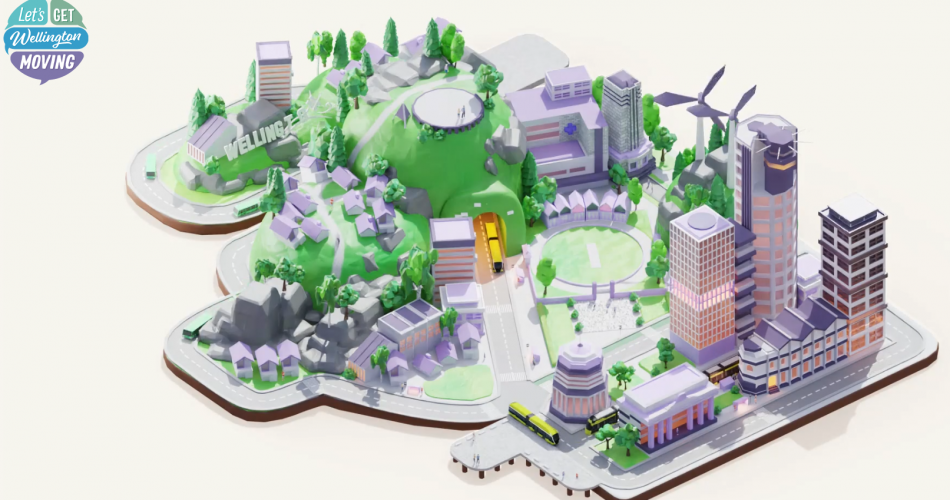
Hi all. It’s been a long time since I’ve posted (feels like it could be ten years). But I’m back to raise some major flaws with the LGWM plans because this has been a near and dear subject to me over the past 20 years.
None of these flaws appear to be necessary compromises forced by cost or other constraints. And it appears we could fix them without additional cost. If we do fix them, we’ll have a much better transit network for Wellington. We won’t get a shot to do this over, so we should do it right.
Aside: I haven’t been able to digest absolutely everything, and not all documents have been made available, and my questions haven’t been answered. But from what I’ve reviewed it seems strange to me how much the process abruptly changed and was rehashed over the past couple of years, only to quickly push out this rather odd consultation.
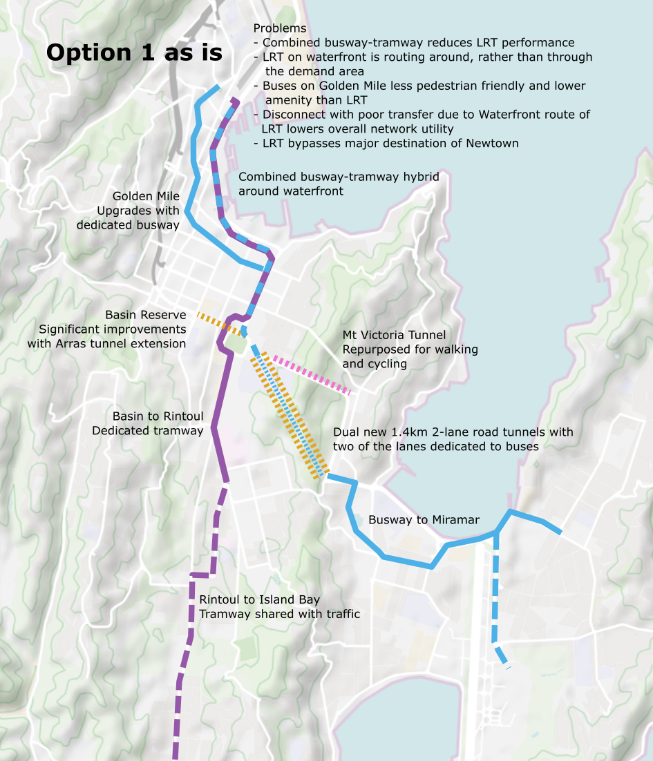
Flaw #1: Waterfront vs Golden Mile

Along the way it was correctly identified that we needed a second “spine” for transit through the central city. It’s not feasible to run enough buses per hour on a single two-lane alignment for the future demand (we already run into problems). To increase capacity, we either must upgrade to a higher capacity mode (e.g. Light Rail), or increase the number of lanes. In Wellington, going “wider” with more lanes isn’t possible, so we must split services across two separate alignments (“spines”).
While upgrading to Light Rail has long been discussed for this very purpose and could indeed carry the volume of passengers on a single spine, it’s not practical to replace all bus services with Light Rail. All would need to transfer to Light Rail to make this work, and while this makes sense for a the smaller infrequent services at the far edges of the Light Rail network (and can in fact make for a better experience), it becomes punitive for major services such as those to Karori that would be forced to transfer at Lambton Quay. So, two “spines” for transit through the city were inevitable.
Originally the preference was for Light Rail to traverse the Golden Mile and for the bus services that are retained to be routed along the Quays. The reasoning for this is quite straight forward:
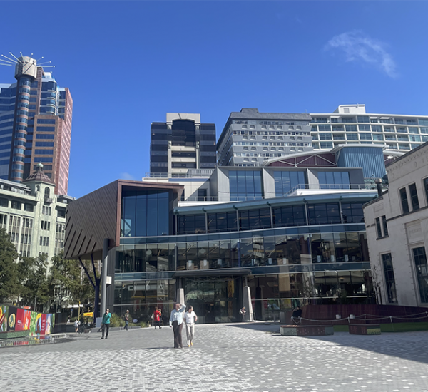
- The Golden Mile is the primary destination/origination for trips in Wellington and has a wide catchment area for the whole stretch along both sides, up to The Terrace, up into Te Aro, and towards the waterfront.
- The high capacity, high quality transit option that carries the majority of passengers should align with where the greatest demand is. That is clearly the Golden Mile and surrounds.
- This is also better for passengers arriving from suburban rail services headed towards destinations not within walking distance of the train station. It will distribute them closer to where they want to go with a simple, don’t-have-to-think-about it transfer onto Light Rail.
- It is much-much better for circulation of people in the central city during the inter-peak periods, which also helps improve the economics of running Light Rail. Going from your job on Lambton Quay to meet your friends for lunch in Cuba St? Or a business meeting on Tory St? Much easier to walk outside to the Light Rail that is conveniently closer to you on the Golden Mile, not think about what bus you must catch because it’s a train, wait for 1 to 2 minutes for the next train, jump on, and ride to within 100 meters of your destination. The Quays alignment is simply terrible for this, it does nothing for daytime CBD circulation.
- This aspect is actually further enhanced with potential extensions of Light Rail that might be considered in future such up Molesworth St.
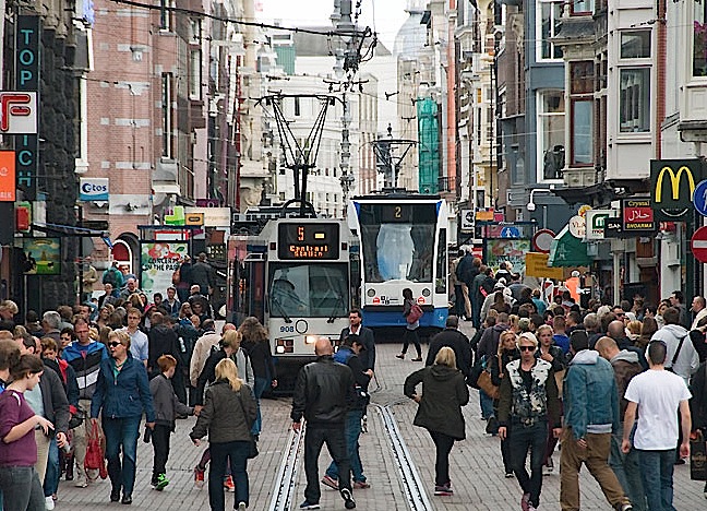
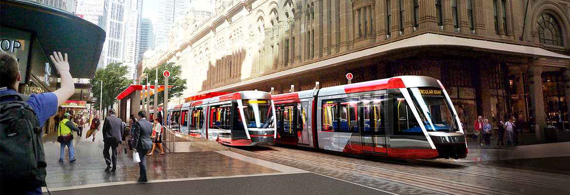
- The Golden Mile is an extremely pedestrianized environment. It will be becoming more so with the planned rebuild. And Light Rail performs better in a pedestrianized environment and has a much higher amenity value, making for a better result after the rebuild. Light rail would have less than 24 vehicles per hour vs the greater than 60 buses per hour predicted in the LGWM proposals. That’s a lot less bus-dodging to do while perambulating with your coffee in one hand and fixating on your phone in the other.
- Intersecting the two alignments creates a network with better transfers, with close to cross platform transfer designs being possible where the two alignments cross at Taranaki St in the south and Lambton Quay in the north. (More on this later.)
What do you think works better for a pedestrian environment? Buses like what we have now or Light Rail like…

The Problem
The options currently route Light Rail via the Quays and continue to keep regular buses on the Golden Mile.
- This means the “masses” in your brand new, high quality, high capacity “mass rapid transit”, is being directed around their preferred destination.
- This means for most users now on your network they are going to have to transfer to a lower quality bus service at the very fringe of the city to get close to their destinations. Transfers to buses are complicated and undesirable. They are confounding due to the many different routes that buses follow and lack of certainty about their destination.
- Most users now face a 200m-400m additional walk to get to where they are going. After first crossing between 2-6 lanes of traffic. That’s a lot of extra time, it sucks for able bodied people, but it’s an even bigger barrier for disabled people. (Being disabled now I’m a lot more sensitive to the impact good transit can have on quality of life, and this would be considerably worse for me.)
- Transfer opportunities between routes are much worse because the routes don’t intersect. Transfers require longer journeys away from the direction of intended travel and very long walks. A huge barrier for enabling people to take public transport to destinations other than the CBD or train station (it’s all very train station oriented isn’t it).
- This means you take the opportunity for transformation with a high quality Light Rail system, that works well with in urban pedestrianized environments, and push that out to the edge into the middle of a 6-lane mini-highway.
- This means it does nothing for improving daytime circulation within the CBD.
Why did this happen?
I thought this was odd when the Golden Mile improvements announcement was made earlier in the year but couldn’t get any information about how the decision was made. But now sifting through the newly released documents and following links in the footnotes I found two documents that shed some light on it [A and B]. Below is the reasoning given for putting LRT on the Quays.
Most of these are simply wrong and this is nonsense. It is so utterly weak for such a major decision that affects the city for the next fifty years. (I mean my mind is blown and I feel like this deserves copious swear words, but I’m trying to be reasonable and presume I’m missing something very profound. But did we really so utterly screw up our LRT design for this?)
Significant urban regeneration opportunities – a number of key sites identified
- The QnA document lists a few sites such as the MFC car park and Civic Square. But the reasoning here is very-very weak. And the justification is backwards:
- They are saying LRT helps urban regeneration, and that therefore we should bypass most of the city to help attract redevelopment of a few parcels next to a traffic sewer.
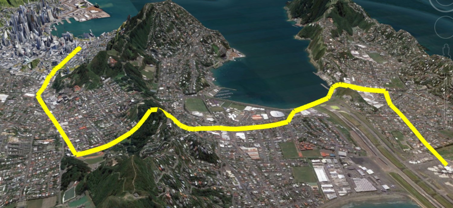
- No way. Look at the above picture of Wellington. There is no way that a few small parcels of development potential can outweigh the many orders of magnitude more already existing development, and the orders of magnitude more parcels that could be redeveloped in areas adjacent to the Golden Mile that will be worse off under this proposal.
- This reasoning is backwards.
Attracts urban activation and pedestrian movement beyond the Golden Mile
- Along what will still be a 4-lane highway with a 2-lane busway in the middle of it under these proposals. Meanwhile the Golden Mile is having a worse time of things because of changing times and could probably use a boost.
- The waterfront itself is already a highly pedestrian environment, but it is never going to match the Golden Mile, because it is at the edge of the city, not in the city.
- If buses would supposedly be good enough for the Golden Mile (a highly activated and pedestrianized area with greater demand) in their preferred plan, then the reverse should be just as true for the waterfront.
Slightly faster travel speeds and a straighter, more direct route
- This is maybe telling of the mindset. According to the documents this saves only a projected 1-2 minutes off the Golden Mile.
- Since when did travel time to the train station become the primary goal? We aren’t optimizing for getting people from the Basin Reserve to the train station the fastest. We want to optimize for (1) getting the most people where they want to go, and (2) creating a better network with convenient and fast transfers that enable more people to take trips to places they previously wouldn’t.
- When you consider the extra walking time for most people to get to their real destination any travel time savings for people outside the city going to the train station are more than outweighed by the increased travel time for the majority of passengers that are actually going to destinations along the Golden Mile or wanting to transfer to other directions of travel.
- Why are faster travel speeds around the primary destination for most people an argument?
Improved connections to the waterfront
- Why? How? Not explained. So why not just do this anyway?
- You don’t need Light Rail to improve connections across the Quays. In the proposals to build a busway-light-rail-frankentransit-combo they are planning a busway along the waterfront alignment as is. So the result is still the same if you run Light Rail through the city and buses along the waterfront, you’re still doing the same work on the waterfront, building the same facility with same aesthetics, and can still make the same improvements.
Better resilience following a seismic event due to less risk from fallen buildings/debris
- This one is the only one I give any potential points for. But I still think it’s mistaken:
- In the QnA they say the risk of liquefaction damage is greater on the waterfront than golden mile, but the risk of building damage is greater on the golden mile than the waterfront. That after a major earthquake the demand on the LRT system is less due to CBD closures. But that in a minor earthquake some buildings may become damaged and cause localized closures. This is more likely along the golden mile.
- In summary, in a major earthquake everything is fucked. We’ll be running buses for a while, people will work from home, the CBD will be dead.
- In a minor earthquake, a building along the Golden Mile might become damaged and that street must remain closed for a few months until it’s demolished. This will be more disruptive because other parts of the city are fine, but LRT runs along that street.
- I think this is worth considering. But the events we are talking about are very rare, we are talking about the potential for very infrequent (I mean what is it, a hundred years?) impacts where the LRT system is closed in part of the CBD due to an unstable building that needs to come down. Is it worth forever hobbling your system in all the good times for that? I don’t see how.
- This is not quantified in anyway it’s just workshop/brain storming type level of stuff. And I really don’t see how this one, maybe interesting line of thinking, can be used to make such a key decision. There is no real analysis of where this could occur or what mitigations could be taken, or how long it might impact services, or what other ways services would be impacted anyway during such a rare event. Or how recovery plans could restore service in the event of a long closure.
- Naturally bus services could continue to run in such an event. Light Rail services could continue on the unaffected parts of your system. (Lambton Quay is really where the risk is presumably. So service would continue to there.)
Easier to build due to width of corridor and ability for partial-only closure; less impact on existing bus services and existing retailers.
- Huh? But we are now planning to REBUILD the whole Golden Mile anyway and for buses? So, it makes no difference if we put some track down.
- This is silly. Clearly you’d build the busway as planned in their current proposals on the Quays first. This allows rerouting of bus services onto the Quays during reconstruction of the Golden Mile during which tracks are also laid down. This phasing actually makes more sense than building Light Rail on the Quays so that what, you can reroute buses onto your Light Rail on the Quays while you rebuild the Golden Mile for the buses you just moved to then after move them back to the Golden Mile.
Quicker construction time, may save on disruption and some cost.
- Again, what? See above. We are literally proposing now to rebuild the entire Golden Mile AND build a new busway/tramway-franken-combo around the waterfront. So, this it out as a reason too.
How do we fix it?
We are planning on spending hundreds of millions to rebuild the Golden Mile, just to continue to carry buses. And then to build a busway-tramway-franken-combo around the waterfront for bad, totally spurious reasons. That major Golden Mile investment would be better held back and used concurrent with the construction of Light Rail to convert the Golden Mile to a fully, 100% pedestrianized route with a modern, French style tramway along it. The massive costs proposed for repaving, altering kerbs, and so forth that is planned would better fit a tramway build than replacement with status quo buses.
The phasing would work well as the current LGWM options all build a new busway around the waterfront. When construction is ready to begin the first phase is to build the bus lanes on the Quays (whether its a center running busway or kerb running bus lanes is left for detailed design). After that bus services between Taranaki St and Lambton Quay are relocated. Construction is started on that section of the Golden Mile inclusive of Light Rail. After which Light Rail services start between the train station and Taranaki St interchange. Then follow on phases continue to extend Light Rail south and east as discussed later.
Flaw #2: Broken interchanges and transfers equal bad network
Transfers are good! They get a bad rap. This is possibly because people only have the experience of transferring from a low frequency bus service to another low frequency bus service. This is an anxiety inducing kind of transfer because there’s a wait involved, you’re not sure if your first bus will arrive in time to meet the second, or if the second will be there, etc. And buses suck.
But transfers work differently when one of the legs is a higher frequency, high quality service that is reliable like Light Rail, and perceptions improve in this scenario.
Done well, with interchanges placed at good locations and transfers being easy without barriers such as long walks, or crossing busy roads, enables a more interconnected network and far greater reach of destinations. This drives more use of the public transit for trips other than commuting to-from the CBD.
Also often ignored, but very important, is that transitioning some bus services to feeders means that they can offer higher frequency using the existing resources, which actually improves public transport for people on those feeder lines.
To illustrate with an example:
Consider we ran Light Rail along the original alignment through a tunnel from the Zoo to Kilbirnie. We now have frequent, high quality transit pulling up every few minutes at a station by the Zoo. Someone who lives in Melrose and currently has the #23 bus to the city running only every 30 minutes during work days and hourly on weekends. This bus runs 10km from end to end (Houghton Bay to the train station), and takes 47 minutes.
The section from Haughton Bay to the Zoo is 3.4km and takes 15 minutes on the current schedule. Using the same number of buses and drivers currently deployed the operating frequency could be tripled along this stretch. Now instead of two buses an hour, or one an hour on weekends, the person living in Melrose can catch a bus every 10 minutes on weekdays. That’s turn up and go frequency. Or can catch a bus every 20 minutes on weekends, making possible lots of trips they otherwise would use a car for.
Inbound their experience is they walk to the bus stop, catch the next bus to the Zoo station, walk a few meters, wait 1-2 minutes for the next train, and have a comfortable ride into the city. Or if they are heading to Miramar or the airport, they take the train the other direction.
Similarly outbound from the city, they wander to the local Light Rail stop from their office, don’t need to have any anxiety about missing the one bus every half an hour. Don’t need to squint and look at each approaching bus number down a long queue of 4 or 5 buses. And they catch the next train a minute after arriving. At the Zoo they get off. And within a few minutes the need feeder is ready to turn around and take them up the hill.
The more able bodied now also have the opportunity to ride down the hill on their scooter or electric bike, put it in a station bike locker, and take the train into the city.
The Problem
All options put forward by LGWM make it difficult to transfer between bus services and the new Light Rail/BRT services because the systems don’t intersect at useful points. This creates a poor network where opportunities to take public transit for non-CBD bound trips are much worse than they need to be. It also means feeders must continue as one-seat rides with lower frequency. It means more buses in the city than would otherwise be needed.
It’s not clear how transfers were considered or how they influenced the evaluation. The assumed bus network changes under these new options aren’t shown and it doesn’t appear to be discussed in the recent documents where plans deviated from the original routes.
But we do see at various points in the documents that transfers were considered bad. It seems preference has been given for one-seat rides to the train station, with the fastest possible travel time to the train station. And this seems to influence why the original route via Newtown to the eastern suburbs with Light Rail, 100% segregated right of way, was discarded in favor of a busway. Which in turn is how we ended up with the busway-tramway-franken-combo.
Below are some examples of the bad interchanges due to Flaw #1 above.
- Passengers to/from Karori have a 400m walks plus multiple crossings of large streets to get to the proposed Light Rail terminal.
- Passengers to/from Brooklyn & Aro Valley have to pointlessly continue all the way through the city 1.5km out of the way to then walk 220m and cross multiple large streets to get to the Light Rail and then travel another 1.3km back in the other direction.
- Passengers from Taranaki/Wallace St have to walk 290m and cross multiple large intersections to get to the Light Rail.
How do we fix it?
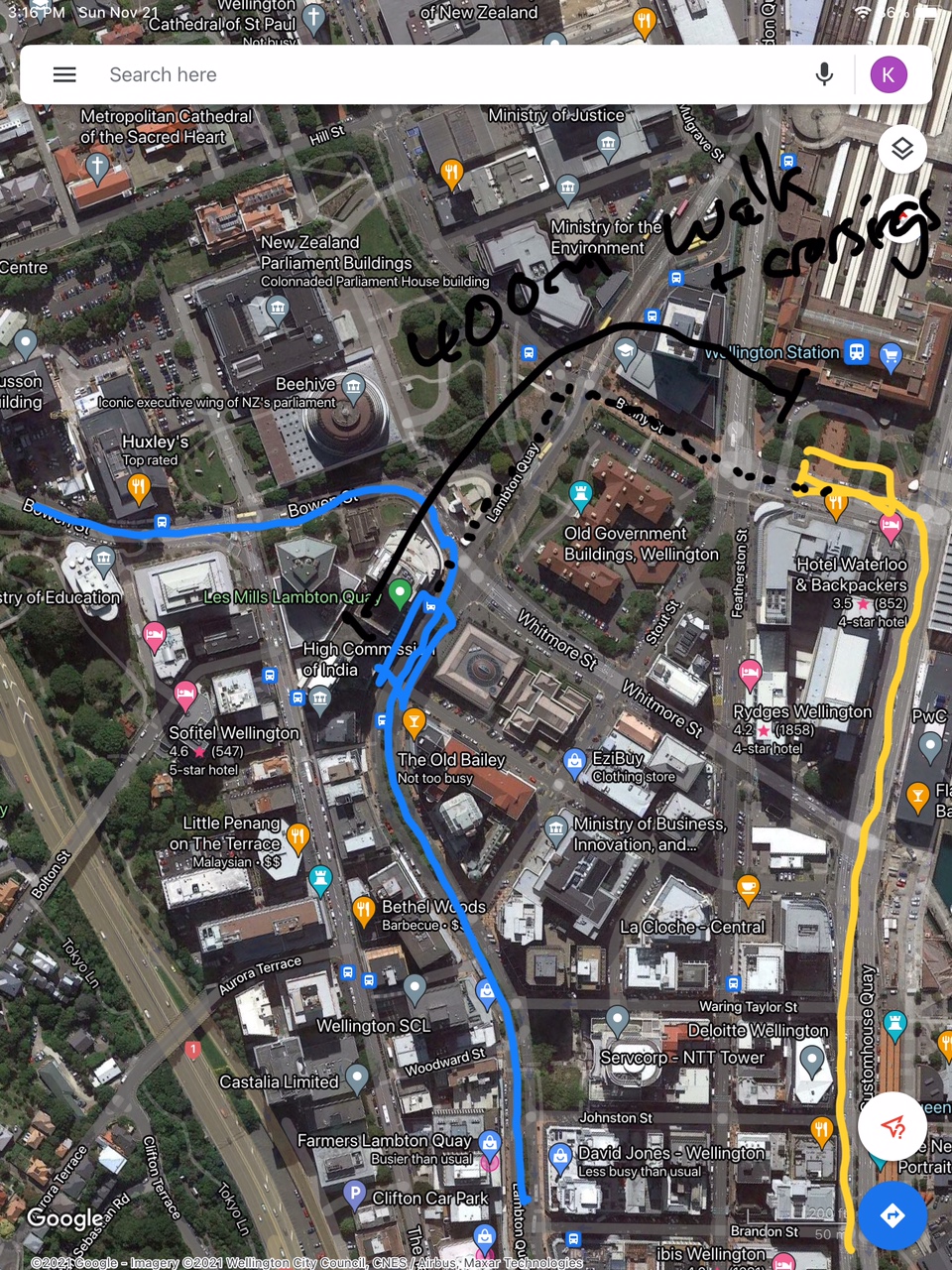
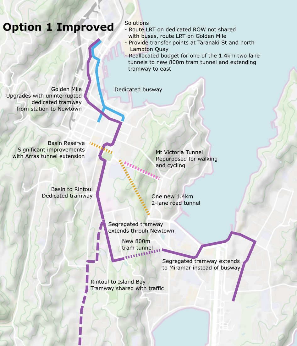
First, as discussed under Flaw #1, reverse the decision to put Light Rail on the quays, and instead moving it back to the Golden Mile, with buses running along Taranaki St, a portion of the Quays and then northern Lambton Quay. This will enable two key new interchange points between bus services going in all directions and the Light Rail lines at Taranaki St in the south, and Lambton Quay in the north.
Note since the decision to close Dixon St, the interchange at Taranaki St can now be fully pedestrianized with no crossings required.
Excuse the crappy sketches, but you get the idea:


Now for example someone from upper Te-Aro, or Brooklyn, or Aro Valley has a convenient transfer at a fully pedestrianized interchange to light rail along the golden mile, or if they want to head towards Newtown, or Island Bay or Miramar they haven’t been forced to either walk 300+ meters to transfer, or to ride go all the way to the train station to transfer and then backtrack.
Second, by running Light Rail to the east as discussed below, we enable high frequency feeders for the currently low frequency routes and better service for those on the feeder lines, plus more connectivity between people wanting to go to destinations other than the CBD. Such as from eastern suburbs to Newtown, the Hospital, Brooklyn, or Island Bay.
Flaw #3: Frankentransit of Mixed Modes
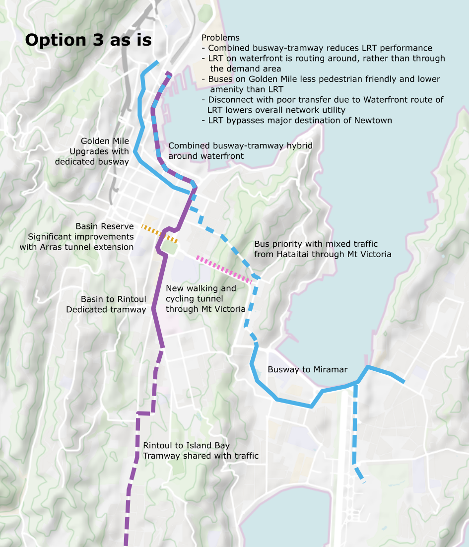
Three of the plans create a Frankentransit of buses and light rail. The fourth has no light rail.
Bus and light rail should absolutely not be mixed except in limited, short sections, and should not share stops. This is easily fixable, since selecting buses as the mode for reaching the eastern suburbs seems to have been predicated on some bad decisions. But we can fix it and make everyone happy.
Over the decades plans for Light Rail have taken a few routes, but the common one is to head down Cambridge and Kent Tce, Adelaide Road, to Newtown, then from the Zoo a tunnel to Kilbirnie. From there either to Miramar then the Airport, or some prefer direct to the Airport. There are lots of good reasons for Miramar first and that is why it ultimately won out over time. After this, future expansions would add a spur to Island Bay, and maybe a route from Lyall Bay via Hataitai and the existing bus tunnel.
(cough I think I was the first to propose and promote the Miramar first alignment way back in the day. cough But that said there is new information that’s making me somewhat reconsider, but that’s maybe a subject for another day.)
This route was also selected by LGWM during the earlier phases as the preferred route. Good so far!
But then in the last couple of years something changed and Light Rail to Island Bay became preferred. But then somehow that morphed into Light Rail to Island Bay and BRT along SH1 to the eastern suburbs and merging them onto the same alignment through (now around) the central city.
The explanation for this is:
- Slightly higher development potential in Island Bay than the eastern suburbs. But it is slim. And it also looks quite questionable. (As in changing some assumptions could give different results.) But it’s not worth nitpicking too much on here, and besides I’m fine with Light Rail to Island Bay.
- Wishy washy stuff about how Light Rail on the preferred alignment duplicated the #1 bus to Island Bay. This doesn’t really stack up, by the same logic the enhanced bus proposed in the new options duplicates Hataitai services, and the buses to Newtown duplicate the Light Rail, etc.
- Stuff about how transfers are bad and people need to get to the airport really fast. The route as originally planned would have been about 2.5 minutes slower from the documents (though I think it could be more like 5 minutes slower).
And so now they decided they could only do Light Rail to the south, and the buses to the east, and to mix the modes in the same ROW. Bad idea.
The Problem
- Building Light Rail to the edge of Newtown and then bypassing Newtown proper is an absolute crime. There is massive development potential in Newtown and it should be served by light rail through its core.
- 50% of the new proposed light rail line to Island Bay is on street running mixed with traffic. This really demolishes a lot of the argument for building Light Rail in the first place. A high quality service, stuck in traffic.
- We are being told that the south has greater development potential (it’s marginal even by their own figures) and so they are telling us they want to build LRT to somehow support that because it’ll result in a few thousand extra homes than otherwise won’t be built. As if what is preventing people from building homes in Wellington is that they just don’t like not having LRT. Huh? No it’s because for decades the city council has actively prevented it! If you dropped 50,000 dwellings into the city tomorrow you’d have no trouble filling them with the hundreds of thousands of people who want to live here but can’t find space.
- TBH, I’m not saying it is, but the reasoning around this all is so wishy washy and smells like some kind of corrupt North American TV drama where a developer owns a bunch of brownfield land and wants the value of their land to increase so has the city route the new streetcar past their land.
- So anyway, we’re going to massively increase the population of Island Bay (good), but half of the route is mixed with general traffic on the only two-lane road in and out of the suburb. So, all that extra population that is expected will also drive somewhat, and traffic will increase, and this will affect the performance of LRT.
- We went from what 100% segregated light rail all the way to Miramar and the airport to a line to Island Bay that is 50% mixed with car traffic, and 25% mixed with bus traffic, and only 25% dedicated to itself, and that still bypasses Newtown.
- We have now added a long expensive section of “BRT” that is purely express, it has no stops, and it bypasses people by going around the suburbs. That is spending a hell of a lot of money to get an express section that duplicates existing services but provides no extra catchment, no extra stops. I thought duplicating services was bad? But now it’s good cuz it’s buses in a big tunnel that bypasses people?
- We are now mixing buses with light rail through the central city to the detriment of service quality.
How do we fix it?
- The section from the Basin to Kilbirnie provides little network benefit. It plans for two new 1.4km, 2-lane tunnels with Bus or HOV lanes. Given LGWM documents are trying to make it clear that there is no new general vehicle lanes, there is no need to couple the rapid transit route to the general traffic route with this tunnel proposal.
- Because of this we can decouple one of those two new tunnels and “spend” that 1.4km of 2-lane tunnel budget supposedly dedicated to transit elsewhere. Along with the approximately 1km of approaching busway from Kilbirnie to the tunnel portals.
- We could comfortably reallocate this budget to link the eastern rapid transit to the Light Rail network proposed in Options 1, 3, and 4, via Newtown, with a shorter approximately 800m tunnel from southern Newtown to Kilbirnie. This shorter tunnel is less than 2/3rds of the length of the LGWM proposals, and on top of this may be cheaper to construct than a combined traffic and transit tunnel due to lower ventilation requirements.
- The 2km to 3km of planned busway to Miramar would be built for Light Rail.
- This route would provide a unified Light Rail network both south and east, with high frequency serving the major growth potential in Newtown.
- Improve connectivity between Kilbirnie and the eastern suburbs and Newtown further aiding development potential in Newtown and Kilbirnie both. Newtown becomes a destination not a suburb.
- This also improved connectivity between Kilbirnie an Island Bay, transferring once at Newtown rather than having to transfer to an infrequent bus at Kilbirnie and then LRT at the Hospital.
- Improves connectivity from eastern suburbs to major destinations such as Hospital (one seat ride) and Massey University (one seat with a walk or a transfer to a bus over Wallace St at the hospital)
- Performance of the system is massively improved by not mixing bus and light rail modes. And by having a dedicated/segregated row all the way through Newtown to Miramar
Putting it all together
This consultation is odd. I mean the graphics are great. But the options presented don’t need to be packaged together as they have. There is a lot of overlap between them and there are also a lot of decisions that can be pushed into the future.
Option 3 & 4. Both make a major investment of Light Rail (poorly as discussed above, but a major investment). The only difference is whether to make extra improvements in Option 3 to the Basin Reserve. If these are made then Light Rail would run along Cambridge & Kent Terraces which the reports conclude is a better alignment for the transit network. Everything else is the same.
Option 1 & 2. These options are more distinct with the primary difference between whether the mode used to reach Island Bay should be bus or light rail. They are again otherwise identical.
In summary:
- Decouple general traffic improvements through Mt Victoria from transit planning. There is no reason to link them.
- Transit planning should prioritize the best transit network outcome, not try to supplement road changes by linking them to SH1 improvements such as new twin-bore 1.4km road tunnels.
- Keep the bus system and light rail system segregated. Small shared sections where buses are infrequent are okay, but should never share platforms, and rail should have priority over buses.
- Route Light Rail via the golden mile and buses via the waterfront, and place buses along the quays.
- Provide a major transfer point between the Light Rail and bus systems at Taranaki St and again at northern end of Lambton Quay.
- Use Light Rail to serve the eastern suburbs as well as the southern suburbs.
- Convert low frequency bus routes that serve the periphery of the network into higher frequency feeders.
I propose two new options that resolve these flaws and stay within the budgets of the existing options.

Option 5
Improves on Option 1
- Builds new pedestrian/cycling tunnel as planned in Option 3 and 4.
- Makes the major basin upgrades as in Option 1, 2, and 3, which support better Light Rail transit.
- Re-routes Light Rail along the Golden Mile as discussed in Flaw #1, with buses using the Quays.
- Light Rail to Island bay as in Option 1, 3, and 4.
- Extends Light Rail through Newtown and enabled future extension to east.
Option 6
This is just Option 1 & 2 merged with Light Rail as follows.
- Makes the major basin upgrades as in Option 1, 2, and 3, which support better Light Rail transit.
- Builds new two-lane road tunnel through Mt Victoria as in Option 1 & 2, but instead of doing two of them and dedicated half the lanes to transit, only builds one for the car traffic and reallocates the 1.4km of tunnel budget elsewhere.
- Converts the existing Mt Victoria tunnel as in Option 1 & 2
- Re-routes Light Rail along the Golden Mile as discussed in Flaw #1, with buses using the Quays.
- Light Rail to Island Bay as in Option 1, 2, and 4.
- Instead of that extra 1.4km tunnel in Mt Victoria dedicated to buses, that gets reallocated to build a new 800m tunnel for Light Rail from the Zoo to Kilbirnie and to extend Light Rail to Miramar.
Sequencing
There is a lot of flexibility with these options to adapt as we go. The two first decisions that need to be made are only:
- Do we wish to make Light Rail the only mode rather than BRT or a Bus/LRT-frankenstein?
- Do we want to upgrade the Basin Reserve in order to provide the best outcome for Light Rail?
If the answer is yes and yes then we start work on those elements.
Phase 1.
- Build the busway/priority measures for buses around the Quays to accommodate the secondary spine.
- Then reroute buses onto the Quays while Lambton Quay to Taranaki Street Golden Mile upgrades are performed, which will pedestrianize this section and laydown the tramway and build out the interchanges at Taranaki St and northern Lambton Quay.
- Light rail service starts along the Golden Mile from Taranaki St to train station.
Phase 2.
- Build the necessary upgrades to the Basin Reserve.
- Extend the tramway to a Newtown terminus at the Zoo.
Phase 3a.
- Build the tunnel to Kilbirnie for LRT and extend the tramway to Miramar. Convert bus routes such as #3 to run via Hataitai bus tunnel, and convert low frequency bus routes on periphery to higher frequency feeders using the freed up resources.
Phase 3b.
- Build the tramway on street running to Island Bay.
Phase 3a and 3b may be done in either sequence or concurrently.
Mt Victoria
The decisions about tunels through Mt Victoria can be made entirely asynchronously on their own merits. Whether it is preferable to build a new tunnel for two lanes of car traffic along the 1.4km diagonal alignment as per Option 1 & 2. Or whether it is preferable to build the new 800m pedestrian and cycle tunnel alongside the existing Mt Victoria tunnel as per Option 3 &4. The timing of this construction has no baring anymore on the upgrade of Wellington’s transit network.

Welcome back to the Fish, Erentz ! Huge first post – I’d better sit down and start to read that !
Good work Erentz, thoughtful and well considered
Hard to argue with any of this really. I think you’ve articulated the reasons i’m yet to submit on the four choices. It all seems a bit bussiness case led rather than design led. The diagonal tunnel seems especially odd the more I think about it. Why not a new tunnel aligned with the old? Shorter and cheaper. And then the mass transit can pickup about half of Hataitai instead of avoiding where the people are. Doesn’t that increase cost-benefit ratio? How many seconds does the diagonal tunnel save?
I am also a big fan of light rail straight through Newtown, Zoo, then on to Kilbirnie. As you say, the train should go where the people are and Newtown’s main street could be pedestrianised and even the Newtown residents association is calling for density along the main street. BTW with some clever cut-and-cover at the zoo end I measure the actual tunnelling closer to 600m.
I really hope Cr Ponter and Mayor Foster have a read of your post. Not sure it will make any difference though unfortunately.
Yep, I’m not sure how to submit on the four options as given currently either. The diagonal tunnel certainly seems driven more buy road design rather than by transit design, hence it’s pretty great if you’re looking at it from how to improve SH1. Less disruption to neighborhoods. As nemo says below, once you’re starting a tunnel beyond the base costs then you’re paying incremental costs for distance, so if you can afford it it’s a better route for SH1 traffic. Just not at all for transit. So they should separate those concerns.
What would be good is to be able to thrash out a joint response on these pages, open to the public, and then each / everyone do a submission on the issues so the Council etc gets increased numbers. I doubt that they will accept a submission from Nemo at Eye of the Fish, so it may have to be under my real name (so long since I’ve used my real name, I’ve almost forgotten what I used to be…)
Great bit. I think the power probably lies with Minister Wood (or Robertson). You should ask for a sit down. It’s amazing how much of a hash Labour make of light rail
A sit down seems a bit unlikely since I’m no in WLG any longer (boo :() If you want to share the blog with the ministers please do, maybe they’ll ask for a reconsideration of these key points. If they’re committed to LRT as 3/4 of the options are, then fixing the Golden Mile vs Quays issue and selecting the better Basin upgrade option allows them to proceed right away with it and the Golden Mile upgrades. Whether it ultimately extends east, or whether there’s a new road tunnel or pedestrian tunnel are all then able to be decided with more time and plugged on later.
Hi Pedge, and Conor, and of course Erentz. Just a note in regards to the diagonal tunnel – and I’m not a tunnelling expert, but then again, who is? – my reasoning is that the main cost of the tunnel is in the setting up of the whole machinery etc – once you’re underway it doesn’t matter so much if you are going 100m or 200m – you’ve still got to pay by the metre, on top of that initial charge to get the tunnel started. If you make a short tunnel next to the existing tunnel then you still have the whole thing about the town belt and Wellington Road to deal with – but if you were to make a diagonal tunnel then you can short-circuit one area at least. But I think the whole tunnel proposal is faulty anyway. Makes no sense to build another tunnel there. Haitaitai is not the destination for anyone except Haitaitaians anyway. Kilbirnie, is a destination for more people, as is Rongotai College or the Indoor Sports Centre, or Scots College, or the Airport, or Weta Workshop. And of course the Hospital is a major destination.
Anyone can tell that the best thing for a city to do would be to join up the major destinations – so a route from Miramar, Airport, Kilbirnie, Newtown, Hospital, Courtenay, Civic, Beehive/Railway Station would quite simply make the most sense.
Great post, and very encouraging that other people are independently coming to the same conclusions as we are! You can’t argue with common sense… even if LGWM are trying.
We agree, a Golden Mile route and an eastern final destination (via hospital, zoo, etc.) are a sine qua non for the maximum effectiveness and uptake of LRT.
The only thing missing here is the need for the gauge to be compatible with the existing KiwiRail gauge to allow for future integration. But we think the Johnsonville line should immediately be converted to LRT as there is only commuter traffic on it, so no track sharing with heavy rail is involved. Two big advantages in this:
1. You can use the existing Matangi depot and avoid the need for an expensive brand new depot.
2. You can extend the LRT in small manageable stages, rather than having to build at least 5-6 km in one go, with depot, too. That also reduces the disruption during construction.
That leads me to the only fault I could find in this post: The third bullet point in your Phase 1, namely LRT from WRS to Taranaki St. That’s far too short for an effective LRT route and where would your depot be? However, if it was a small extension of the Johnsonville line, then great!
As for submissions, LGWM told me you don’t need to comment on the four options. This is a bit dishonest, as the man in the street won’t think outside the square they have imposed with their four very similar options, so will just answer their questions and give a preference. For anyone who is stuck, our website has a suggested text that can be copied, edited if required, and emailed to them.
That website being http://www.tram-train.org.nz
Thanks for that Filosofos.
There’s nowhere on your website to make a comment, that I can see, so I’ll make a comment here and hope that you come back here and find it. You make a lot of good points, but in case you are interested, there is indeed a big difference between destinations of Island Bay and Kilbirnie/Rongotai. Its all in the soil, and the tsunami susceptibility, according to a GNS Science report. Yes, Island Bay is low lying, and has a small flat delta area, but under that flat area there is still firm ground, and the solid rock of the Island itself will absorb a lot of the energy from the tsunami. But the Rongotai area is not only also low, but the beach profile means it is much more susceptible to tsunami, and their research shows that this area has been hit many times before over the last few millennia. But also, the soil type there as a result is highly prone to liquefaction, and hence why no-one wants to build any high-rise buildings here. If and when the Alpine Fault snaps and releases all that energy headed this way, Kilbirnie/Rongotai is the area likely to get hit quite badly (and the flat areas of Miramar will also sink into the mud). I think that is the real reason behind the switch from the Airport route to a route more direct to the South coast.
This also appears to be true for the Quays, so we’d hope for some consistency at least from LGWM. Seriously the fact we allow tall buildings so near our waterfront I think makes a mockery of this concern. http://www.gw.govt.nz/assets/Emergencies–Hazards/combined_earthquake_hazard_map_wellington.pdf
Having worked on projects on the Waterfront in Wellington (like many architects in Wellington), I can assure you that these issues are indeed taken into account by architects and engineers on the tall (and small) buildings along there. Its probable though that a 3-storey house in Lyall Bay would not have the same level of engineering protection, as a 12 storey building on Jervois Quay…
@nemo & @Guy, this is such an interesting aspect that isn’t clear to me. I’m a lay person and haven’t read the reports you have. Just putting aside that as far as transit goes as Filosofos says below, there is clearly an existing high demand to the eastern suburbs that needs to be addressed (it was called out specifically in the LGWM documents). On top of that it there will still be *a lot* of development in the eastern suburbs under the adjusted plans on top of that existing demand. So LGWM is inconsistent here.
But from a city planning aspect. How do we grow a city when so much of it is hazardous in an EQ? Is it really time to close the door on Wellington? (Has this been posted on before?) Not just Wellington, but most of Petone/Lower Hutt is at the highest risk levels as well. So we should be concentrating more building in Kapiti and actually build a nice city there instead of the sprawl that’s spread like a fungus? Should we spend billions expanding an airport there and other infrastructure at all or move that?
@Guy – can we build three story terraced housing that’ll be as survivable two story detached housing? Most of southern Miramar is in a higher hazard zone and targeted for low-density detached (status quo) in council plans, but could (probably) comfortably accommodate triple the population in three story terraced housing. In a major event this area (like many in WLG) is wiped out whether it’s high rises or low rises. We want people to survive but we don’t necessarily need buildings to survive right?
Anyway the whole growth aspect of this is very pessimistic, the perpetually pessimistic population projections problem of Wellington’s planning. Let’s only plan for 80,000 new people in 30 years when we already have displaced 80,000 people who would already have moved and lived here if we’d properly accommodated them over the last 30 years.
Cheers Guy. Though LGWM calculation’s will be based on housing supply enabled which will all be 6 or more stories around transit stops. Don’t know if that changes things enough though.
Look, I’m no expert on earthquakes but I know someone who is, so will ask, so thanks for pointing this out. My understanding was that during the “big one”, the isthmus will rise. Unless I’m mistaken (and I don’t have time to read up on it) Miramar was an island and reclamation of the isthmus became possible because of the uplift that took place in 1856 or thereabouts.
Besides, all this ignores the fact that there is already existing high demand from the east (LGWM’s own figures), so why ignore that and base the LRT on projected future demand? Makes no sense to me. Is the new LRT projected to be under-utilised until the development takes place? Is Kilbirnie and all existing high demand destinations there (ASB Sports Centre, Aquatic Centre, St Pats College, Rita Angus) to be abandoned and put into a state of managed decline? These are awkward questions that LGWM needs to answer. Does it make sense to base the major destination of LRT on geological events that have occurred “many times before over the last few millennia”? Not to me, it doesn’t. Besides, as our website states, the LRT can be extended to meet future demand anywhere, not just Island Bay. The important thing is to have maximum ridership of LRT and get maximum cars off the road from the beginning. I thought that was LGWM’s mission.
As for submissions, yes, our website is very rudimentary. Our suggestion was to try and engage those who haven’t followed LGWM closely and don’t have the time or relevant knowledge (obviously doesn’t include you guys!), to copy and paste the two paragraphs as I have done here, and email them to LGWM:
“Your four options are very similar, offer no real meaningful choice and I don’t like any of them. Genuine consultation would include genuine alternatives, such as a Golden Mile route for light rail, which is my preference. Another missing alternative is to have light rail serving the east (Miramar and the airport), via the hospital, where your own statistics show that there is already heavy demand. This is also my preference. Note that future urbanisation elsewhere can be met as the need arises. Thirdly, light rail is my choice, but it must be specified at 1067 mm gauge (the existing KiwiRail gauge) so that the existing depot can be shared with the light rail vehicles and leave the option of connecting the new light rail system to the existing Metlink suburban system at some later date. To put in a non-compatible light rail system defies all logic.
Furthermore, I believe that light rail to the eastern suburbs should be completed before any further road tunnelling takes place. We may find that once the light rail is operating to its full potential, no further road expansion will be necessary. The bus option to the east appears to be a thinly veiled attempt to justify a second Mt Victoria tunnel, but has the potential to increase car commuting, instead. No second Mt Victoria tunnel is required for light rail or any public transport improvements.”
This is interesting. I will come back and read further comments. Also great to see Conor engaging with this issue. He makes a lot of sense. Maybe next time he can get Peter Jackson to support him? LRT to Weka Workshops… :-) Forgot to mention that as a major employment destination.
Thanks Filosofos, I’ll be cribbing from your paragraphs. I did have on my list of flaws that there was no proper study about expansion to the north and what we want that to look like. It’s a topic that’s divided people into camps over the years, with the tension between what would work best for Wellington’s urban areas vs what works best as a tram-train, vs what the compromise might look like. But I don’t like that LGWM has seemingly just scoped it out of consideration. It should be answered.
Yes, whatever form LRT takes in Wellington the JVL line should be converted to it. I just assume if we start with it in Wellington, we’ll eventually find the momentum to convert in future. The lost opportunity to do this was to start with JVL back during the Matangi purchase, then extend through the city. Now it looks instead like we’ll do it in the other direction. I’m not hung up on whether it happens first or happens later. I also don’t see conversion of gauge on this line a concern for the short and dedicated section track if we go with standard gauge urban trams. Once people are taking a tram from Island Bay, or Miramar to the city, they’ll start saying “how stupid is it that we can’t take one from Johnsonville” and what’s a no brainer to the people paying attention now will become a no brainer to everyone.
But the other suburban lines are a bigger deal. LGWM should have an answer to the question: after all this is built and people are throwing up apartment buildings around train stations in the Hutt – in 2050, or in a scenario where the regional population reaches XYZ – will we want to extend any of the suburban lines into or through the city? If so, at that time, for that expected demand, what options would make sense and what would be required to achieve it? What would be the trade offs? If the best option would be tram-train then that should be known today so it can influence the design of the tramway we build now. (Not just track gauge, but issues like selecting high floor vs low floor, lengths, etc.) I do see it as possible that the required investment to make tram-trains viable at that point with the required frequency/train length, may require such an upgrade that other options for extending suburban service into the city are just as economically viable. But they should give that some proper thought now.
In a flashback to the long distant past, probably to a time when Erentz actually lived in Wellington, former Mayor Kerry Prendergast has written an Op-Ed in the Dom Post. It goes something like this:
“(paraphrasing) We still need to consider cars, for the 80% of people that still use them. And:
The information given on the LGWM website and booklet does not even show a breakdown of transport modes. Critical information, such as how traffic intersects at the Basin Reserve, is difficult to find, and what is available is highly sanitised. It took three attempts and two weeks to get any response.
The concept of a new tunnel taking all public transport and cars to the far end of Wellington Road is excellent. Great, let’s get it built.
Light rail has a benefit-cost ratio significantly less than 1. Steel wheels on steel rails is 1800s technology. The proposal is driven by a small group of rail enthusiasts with nostalgic boyhood memories of trains. The pipes under the rail beds cost a fortune to reinforce or move; rails take up dedicated space for infrequent trains; stations need to be quite far apart, making for long walks; stations cannot be moved as society dictates development or changes its travel patterns.”
My question to you all is: Does she have a point? Is steel wheels on steel rails really just nostalgia? Or do people like Kerry really just fundamentally not understand why a light rail system would be better than a bendy bus?
Oh boy. Her comments just reinforces the early impression in my head that selecting buses to the east and marrying that to a new four lane road tunnel in Option 1 &2 is really about finally achieving four-lanes-to-the-planes in the eyes of many. Perhaps that wasn’t the intention, and no fingers were put on the scales to bubble those options to the top, but we’ll never know. We all know how easy it is to adjust weightings and criteria to get the results you’re looking for.
Well spotted, erentz, that we missed a golden opportunity with JVL. We call it the Matangi Mistake. Wrong type of vehicle purchased, as the ongoing problems on the line attest. As for starting from the other end, yes, better than not doing it at all, but we lose the opportunity to extend it in small manageable stages (less disruption) because we would need a minimum length of line to make it viable. And don’t forget the depot issue. That last issue must surely be yet another powerful reason why we should never contemplate using standard gauge anywhere – not in town, nor in JVL. A falsehood that has circulated in the past is that standard gauge is cheaper. No one buys LRT vehicles “off the shelf”. We didn’t with the Matangis, nor Auckland with their CAFs.
Did you guys notice the diagrams in our website? The table is from Japan, showing a 287% increase in patronage when two former end-to-end stub terminals were joined to provide direct through service. The bar graphs show four examples from Karlsruhe, where I spent 5 days in 2017, the year they were celebrating 25 years of tram-train. We were studying a similar solution at the same time (1992) for Wellington but ours ended up in some pigeon-hole. Twenty-five years later, we are still ignoring the evidence coming from overseas. We think we know better.
As for Dame KP, well, I’ve put together a response which I might share with you later, in full. Suffice to say that every year more and more cities (some smaller than Wellington) are putting in light rail of one form or another and not worrying about their investment becoming redundant any time soon. That’s a lot of “rail enthusiasts with nostalgic boyhood memories”, a phrase Dame KP contemptuously uses in her op-ed. This is an undisguised emotive anti-rail rant put together by someone without a modicum of expertise and possibly with vested interests.
Yes, the steel rail is 1800s technology but it has come a long way since then, as high speed trains demonstrate in several countries. The wheel is even older than rail. Should we dispense with that, too? These are totally stupid arguments from her. Technology ageism!
The autonomous vehicles she espouses would cause even more congestion, running empty to their next assignment. She wants more buses, but weren’t too many buses the problem in the first place?
As for the number of car commuters, (actually around 68% in Wellington) that is not a preference for driving, as many of these are “captive drivers” through not having a better public transport alternative. I was a captive driver. You know what I mean; census questions such as “how did you get to work today?” and if you say you drove, then it’s assumed that’s what you prefer, so you want more road lanes and tunnels.
Hiding behind the thin veil of a “multi-modal solution” is not new. There is no point in road expansion until a decent properly functioning mass transit system is in place but people like Dame KP have a morbid fear of losing road space to mass transit. She’s effectively saying that one person has more rights to road space than 10 others and billions should be spent to satisfy their perceived privilege. You will note she mentions a BCR for LRT but not for roads. That would be too inconvenient. No one is allowed to question road building.
Finally, KP shows no concern for emissions or urban amenity and a liveable city. She was a strong advocate for the flyover, if you remember. Her husband wrote a letter in the Dompost that went something like this: They once ate at a restaurant in Argentina that was situated under a flyover, and hey, it wasn’t that bad, so don’t be afraid of putting in a flyover at the Basin. I’m not joking. John Key was another example. He said on TV that the rejection of the flyover was the reason we couldn’t have progress in Wellington. The interviewer didn’t call him out on that.
That’s the sort of nonsense we’re up against and unfortunately the masses lap it up and believe it.
Filosofos – I completely agree with you about Kerry P and John K both sneeringly referring to LR – both rather ignorant on the subject, unlike yourself who I know has spent a lifetime researching this subject. Anyone that supported the Flyover and didn’t understand that it was a foolish solution gets zero support from me.
I don’t travel own the J’ville line very often, but when I do, I find it delightful – it is like a ride in Jurassic Park, passing almost instantly into a fantastical world of tunnels, wild bush, flying dinosaurs (well, Kereru), and some great friendly little stations up the valley. I’m perfectly happy with the Matangi on that line and not sure what you see as the problem with them on that line – but I agree that Matangi going through the city might be a bit too much? The problem with J’ville line to me is not the trains, or the gauge, but the fact that most of it is single track and so there is nowhere to pass and hence rather slow – that I can understand.
If we are to have a system on steel rails running through the city I completely agree that we need two separate lines of tracks for the system to work – the entire length of the system – and we simply can’t afford to go down to one lane tracks anywhere on that route or you are forever condemned to go only as fast as its slowest section, whether it is LR or HR or Metro. And let’s face it, it would be a budget killer to try and double track the J’ville line. That’s my biggest reservation over linking the systems. We only have one chance at this – we simply have to go for something that is achievable and doable now, rather than continue to tilt at windmills from a future that will never happen.
Nemo, you wouldn’t need to double track all of JVL, just squeeze in one more passing loop and have a second line and platform at JVL station. [As an aside, it would also open the possibility of a later extension to Churton Park, double track, on-street.] And since the extension through town would certainly be double track, you could provide more a frequent and faster service than at present. These are the findings of an expert who did a pro bono desktop study for us in 2013.
The line is very tortuous and steep for heavy rail but ideal for light rail. LRVs have superior acceleration and braking and can handle much tighter curves and steeper gradients, making it easier to maintain schedules. Remember, when first introduced on this line, the Matangis were plagued with flange squeal and wheel slipping. Not sure what the situation is now, I know they tried lubricating the track, but I think slowing down the timetable was part of their “solution”, which is not ideal from a commuter’s perspective. Perhaps the slow pace contributes to the idyllic picture you describe! And you’re right, the Matangis can’t operate on the streets like LRVs.