We’ve been waiting for years for this and although it is not yet official, at long last we are seeing some progress. This was a scoop leaked by the Dom Post – and I’m keen to know more, so I’m posting it up here. While I’m sure that LGWM have gone through millions of alternatives, and fully evaluated tham and argued endlessly over them, for the last several years, this is the first time we’ve seen anything concrete.
Well, not real concrete, of course, but actual lines on actual paper, in a virtual sort of way. One option has the much puzzling “long tunnel” and the other, therefore, is shorter. Let’s have a look at what they may mean in real life.
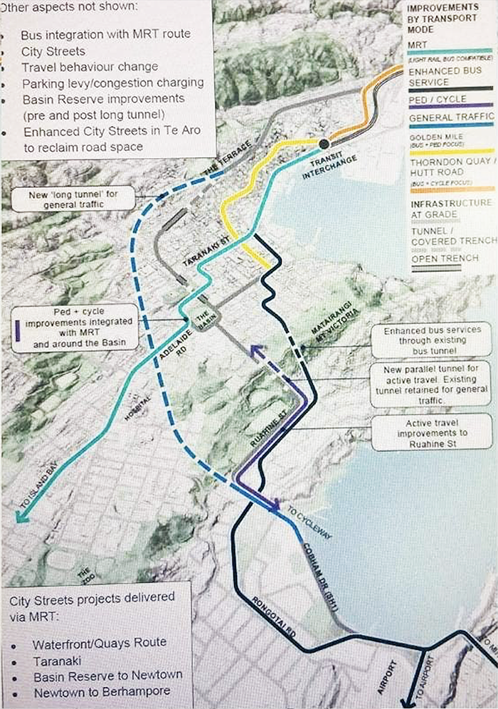
With the “Long Tunnel” option shown above, we can at long last see some evidence of a “masterplan” for traffic routes in Wellington. There’s the MRT (noted here as Light Rail, Bus Compatible, whatever that means) as a turquoise line running through the plans. There’s the Golden Mile in shiny Yellow, of course. The dashed blue line is “General Traffic” which connects from the Terrace Tunnel, in a long, curved, low level tunnel or covered trench under south Te Aro and under Adelaide Road and under Mt Victoria to link up on Wellington Road in Kilbirnie. That’s one way of getting rid of the traffic ! But how would they build a tunnel that long through the centre of Wellington without destroying everything along the way?
Interestingly, we also see for the first time, some real indications of a purple pedestrian / cycleway, which supposedly goes through a “new parallel tunnel” with the existing Mt Vic tunnel kept for existing car users. Local car users that is.
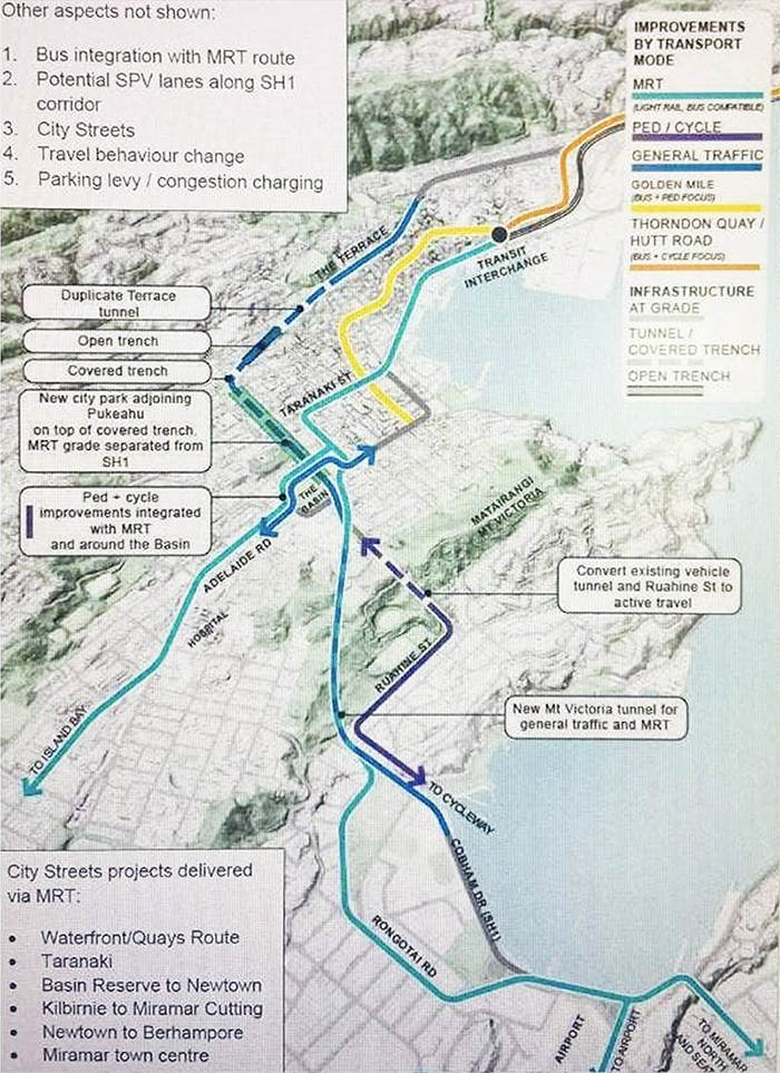
This is the other version, which I’ll dub the “Short Tunnel” version, given that it proposes a new tunnel on a diagonal route for both General Traffic and also for the MRT. What is interesting here is that there is a proposed “new city park adjoining Pukeahu on top of covered trench” and that the MRT would be grade separated from the traffic on SH1. Indeed, it looks clear that the MRT will tootle along the edge of the Quays, then turn up Taranaki Street (remarkably smoothly – I’m not sure how that is actually achieved in real life), and then appear to crank down what looks like Haining St to Tory St where it seems to split into two separate lines – one to Miramar and one to Island Bay. I desperately want to lie this one and for it to work, as I can’t see that giant long tunnel option working, but it really doesn’t seem right to me yet, either.
Hmmm. Maybe give it time…
Are those the only two options that LGWM are going to give us? Surely not! Surely David Dunlop and the team learned their lesson at the Battle of the Basin Bridge, where the tiny community organisations thrashed the mighty Government-backed lawyers and got the Basin Bridge quashed? Is this perhaps yet another cynical attempt to make Wellington froth at the mouth over very little, while they quietly have a third option up their sleeve anyway? Who knows?!?!?


What exactly is “active travel”?
Walking and waving your arms around?
Apparently both you and I missed the bus on that one, 60. I’m told by a reliable source that “active travel” is when you do something other than just sit on your arse. So, yes, walking, scootering, and cycling – which although that does indeed involve sitting on your arse, it also involved legs flailing about. All this as opposed to “passive travel” with is when you just sit there, and someone else does the hard work of travelling for you. Like all those horses under the bonnet of the Holden, or the big bus engine.
Slightly disappointed – saw the headline and thought it was a creative solution to Wellington’s water infrastructure problems. Of course, they could always combine the Long Tunnel with a new pipe, a kind of Cloaca Maxima.
Oh starve, you’re too clever for me. Too cleve for Gonville by half ! Wasn’t the Cloaca Maxima the sewer coming out of Rome? Or was it just the back passage of a very large dinosaur?
To be honest, I do view the SH1 through Wellington as an already very clogged up cloaca – and as the great Joker Jack Nicolson once said to a flying furry friend, “What this town needs is an enema!” And that’s part of the problem – the traffic pours into the city each day like a half dozen undigested hamburgers, and then has to turn around mid-afternoon and try and make its way back up the colon to its place of origin. At least in Auckland you can go in one side and out the other side… here, we have just a one-way passage to nowhere – or the Weta Workshop, whichever is first…
More than 2500 years ago the Romans worked out it was a bad idea to dump their crap into the nearest body of water. Wellington finally stopped doing exactly that when? The 1990s?
A good interview on NatRadio with one of the foremost citizens of Gonville
https://www.rnz.co.nz/national/programmes/saturday/audio/2018814763/frank-stark-bringing-creative-life-to-gonville
It’s worth looking at the Mass Transit page of LGWM. https://lgwm.nz/our-plan/our-projects/mass-transit/ It’s explicitly about connecting the CBD, Newton and the Airport. It’s also explicit on dedicated lanes, something it appears they have been backpedalling on with at least one option recently. It’s clear time and money has been spent investigating options which don’t conform to goals explicitly agreed upon by GWRC, WCC and cabinet in 2019. What’s going on?
But that video is now about 3 years old, and leaves us open to more questions than to answers. Seems to clearly show the MRT going along the outer lanes of the waterfront quays (both sides on outer lane), before then miraculously transferring to the centre lanes of Taranaki St, and then reappearing over near the airport on Cobham Drive also in the middle of the road. Are they just trying to have a bet each way? Or do they really expect the MRT to be able to swap seamlessly across car lanes with no consequences?
Sounds improbable. Though, there’s the video, but also the text “design a mass transit system to connect the railway station with the Hospital, Newtown, Miramar and the Airport”. If memory serves me well they even phased delivery with Phase 1 to the hospital, and phase 2 to the airport in the 2019 package. While I get there are technical challenges, and details to define, I don’t understand why they have been investigating routes that don’t conform to every agreed upon high level route prior as evidenced by LGWM’s own website.
The “Long Tunnel” is a tease, it is always in the promise, but it will never be funded,
“But LGWM Governance Reference Group chairman Daran Ponter told the Herald the long tunnel had been considered and rejected.
It will not feature in the options the public will be consulted on, he said.
“It’s largely on the basis of cost and not doing the job that we need it to do.””
https://www.nzherald.co.nz/nz/mysterious-long-tunnel-wont-see-the-light-of-day-in-wellington-transport-plan/7X4MI7QL3D374JMVDT4GUP7GI4/
A similar item was in the “October 2018 Recommended Programme of Investment” –
https://lgwm-prod-public.s3.ap-southeast-2.amazonaws.com/public/Documents/The-Plan/LGWM-RPI.pdf
it was called ” a new tunnel under Te Aro” to link a new terrace tunnel and the new Mt Vic Tunnel… it wasn’t included in May 2019 Beehive announcement
The November “announcement” will send us back into 6 months of consultations, that will again come up with a half baked conclusion that no one likes or will fund..
The process is broken and TBH I have lost all faith LGWM will actually do any more than a bit of pedestrianisation and cycle and bus lanes…
We will have wasted 6 years and probably spent $100 million on consultants and consultation for pretty much the same the the council should be doing as BAU…
Interested in your thoughts GreenWelly, once you have digested the material associated with the four options to be launched on 1 November.
We’re on the edge of our seats Daran! Stop teasing us! So: one week to go! Looking forward to it!
From the Ministry of Transport’s own page on LGWM: “Mass rapid transit — NZD$2.2 billion has been allocated to provide mass rapid transit as part of the wider public transport network from the railway station to Newtown, and Newtown to the airport.”
Old maps folks. Don’t read too much into what you are seeing. Options will be in your hands in early November and will definitely not include a long tunnel. Shape of LGWM options has changed a bit from the original concept proposals – that is the point of a business case – to actually test the assumptions and likely realities of proposals.
Thanks Daran. Sorry for leaping the gun – I’m just a wee bit tired of waiting, you know, for the last decade or so…. and I thought we had some actual decisions being made! Silly me !
OK – we’ll wait ONE MORE MONTH and then try again….
Hey, A thought has just crossed my mind,
If the MRT will now go south to Island Bay, won’t this trigger the National Policy Statement and force a zoning uplift of pretty much all of the Island bay valley floor and Berhampore to allow at least 6 stories, with no carparking requirements???
Its certainly not something that WCC has raised with residents in the spatial plan consultations??
What happens if this MRT route is approved after the Spatial plan is approved? Does it simply automatically apply, or does the council have to re write the plan for the affected areas??