
Today is the day that the elected Councillors will vote on the Proposed District Plan, which will shape our city for the next thousand years (too long? legally, only 10 years, but who knows how long we’ll be around!). But the Councillors only get to say Yes, or No, even though they will go through it line by line. It is really the unelected Officers who have the power here, who have put the whole package together – they are the ones with the power over our future. That means people like the Chief City Planner Liam Hodgetts will ultimately hold the power. Particularly important for us all is item 56 on the Agenda:
56 The General Residential Zone in the Draft District Plan will now be the Medium Density Residential Zone, and the parts of the former medium density zone that enabled six storeys will now be the High Density Residential Zone (HDZ). This recognises that implementation of the MDRS has effectively made the general residential areas a medium density zone. Three dwellings up to three storeys (and compliance with associated building standards) will be a permitted activity across the Medium and High Density Residential Zones. Under the Draft District Plan two dwellings up to two storeys were permitted.
That’s an inevitable consequence of the Government’s last minute throwing into the pot of the MDRS rules, which are short and not-so-sweet. The extensive careful nuancing of the height limits in the urban curtilage has been thrown out the window – instead we just get the more brutal division between “Everything that was once General Residential will now be Medium”, and “Everything that was once thought of as Medium will now be High”. That may sound OK in principle, but it will have some severe unforeseen circumstances. What are those circumstances, I hear you ask? The answer, of course, is that I can’t tell – they’re unforeseen! But they will gradually out themselves, I’m sure. Following up on item 56 comes items 57, 58 and 59
57. Areas across the City are being up-zoned for high density housing (terrace housing, low rise and high rise apartments) with a focus around train stations, and in and around the central city and suburban centres.
58. Increased building heights are proposed in Te Aro to support future regeneration of this area, including any future mass transit route through the central city.
59. There will be more opportunities for mixed use development in the metropolitan centres of Johnsonville and Kilbirnie, with an increase to the maximum building height in these centres. In particular, it is proposed to raise the permitted building height in Johnsonville from 27 metres (8 storeys) in the Draft District Plan to 35 metres (10 storeys).
That should get the people of Johnsonville excited, and potentially frothing at the mouth. Ten storeys in J’ville would hopefully mean a massively redeveloped J’ville Mall, with apartment towers growing up above the roof level. The lobbying by Johnsonville residents, in particular Tony Randle, has evidently taken a lot out of the Council, who I think have probably spent thousands, if not millions, rebutting everything that Randle says, line by line, in a mammoth effort to not have the future growth of the train station stops reduced along the Johnsonville Line (refer to Attachment 2 in the Agenda). “Many submitters on the draft Plan opposed classifying the Johnsonville Line as a rapid transit service. Julie Ward, Lawrence Collingbourne and Tony Randle recently presented staff with an alternative assessment that the Johnsonville Line is not rapid transit. Staff have considered this assessment carefully. Staff maintain the recommendation that Johnsonville Line is rapid transit for NPS-UD purposes, while acknowledging the Line’s constraints. The Independent Hearing Panel will consider both assessments when recommending whether the Johnsonville Line should be classified as a rapid transit service.”
But I’m most intrigued with the wording in 55 and 56 – “up-zoned… with a focus around train stations” and “future mass transit route through the central city”. Seeing as currently our mass transit trains stop on the edge of the city at Wellington Railway Station, I would maintain that we don’t actually have any Train Stations in the “city”. To me, Tawa and Khandallah really don’t count as city – they are so firmly rooted in Suburb. Item number 102 notes that the Council believes: Based on this assessment, no change is proposed to enabling buildings up to 21 metres (6 storeys) within 10 minute walking catchments of the City’s rail stations as “rapid transit stops”. So – we have a disagreement there. Is it really worth all this bother? Will Khandallah ever have any buildings taller than three storeys?
What else will change? Item 69 will bring an answer to some SNA questions (Significant Natural Areas), including that where:
69 Submitters on the Draft District Plan raised a range of concerns about the provisions as drafted, and a more general concern that the Council was imposing an undue burden on landowners which in some cases will lead to a loss of private property rights…. including…. 70 A number of key changes to the SNA provisions have been proposed to allow day to day maintenance of bush and land, with some clearance allowed where it is close to existing houses, decks, and balconies…. 3m permitted clearance zone around buildings increased to 5m.
Supporters of Heritage may also get a tiny increase:
81 The heritage schedule has been reviewed and 10 new heritage residential areas, 54 heritage buildings, and 4 new heritage structures have been added to the heritage list. These additional heritage items have been included where there is an opportunity to increase representation on the heritage list, they are listed by Heritage New Zealand, or the Council has good information on their values.
I’m not quite sure where / what those 54 Heritage buildings are – there must be a list, but I haven’t found it so far.
High-quality development
- A strong theme throughout engagement on the Spatial Plan and Draft District Plan was the need to provide a good standard of amenity and quality healthy housing alongside increasing housing supply.
- The PDP includes residential amenity controls and supporting design guidance for multi-unit development (apartments and townhouses) across the City Centre, Centres, Mixed Use and Medium Density Zones. These controls include minimum unit sizes, requirements for outdoor living space (private or shared), and daylight and sunlight access.
- A complete review of the Design Guides has also been undertaken. The Design Guides are part of the PDP and have statutory weight. The new Design Guides have been rationalised with improved useability and reflect the current priorities for the City, including supporting growth and ensuring good design outcomes.
New Design Guides – have you seen them yet? Are they a substantial improvement? Have they changed from those proposed in the Draft District Plan?

One of the areas that makes me truly sad is that the Street Edge Height Control proposal, which noted that some modicum of sunlight could be guaranteed into our narrow city streets: Introduced into the DDP to enable sunlight access to the street and a human scale to narrower streets in the face of increased heights and intensification. Applies to street 21m or less in width. Requires a minimum 4m setback after 16m or the width of the street (whatever is greatest).
This is proposed to be deleted, as apparently:
Street edge height control removed. This is because sunlight modelling of narrow street showed that the benefits of this control for bringing sunlight to the street was not significant. There was also strong feedback from the development community that this control would reduce the development capacity of sites, and impose significant additional engineering costs for new buildings.
Which is the biggest bullshit line I’ve seen for years. If your modelling showed that making the street wider and sunnier wasn’t working, then it shows that already the street is too narrow and sun-less. So the answer is you should make it wider and sunnier, not scrap it all together! Are we building buildings just for the sake of building buildings? Or are we building buildings to house human beings in, as the primary measure? Does all the money need to go straight to the pockets of the major developers in the city? Or should any benefit go to the people who chose to live here and work here? To say I’m disappointed is an understatement. What is the point of building if all it does is turn everyone’s lives to shit?
A City For People‘s lobbying for a better city had some effect, in that it was noted – but sadly, seemingly totally ignored: Two-thirds of the 300+ submissions to the Design Guides section were from the pro-forma A City for People submission in which sustainable, well-lit, high-amenity, and well-designed development was supported. Additional submitters expressed support for attention to aesthetics and amenity in planning and the design guides that underpin this.
Hmmmm. People consistently say they want “sustainable, well-lit, high-amenity, and well-designed development” do they? Well, let’s just ignore that then, as they’re just a bunch of whining hippies.
Have a look at this line: under Amenity Controls, The DDP has a building setback requirement (CCZ-S14) ‘Living rooms facing onto any non-road boundary must have a setback of 3m.’ The Building Depth standard is currently 20m, and the building separation standard is 10m.
So what are they proposing to replace it with? CCZ-S14 has been amended to require an outlook space of at least 1m x 1m for all habitable rooms. Building length and separation standards are now less restrictive to allow longer buildings (from 20m to 25m), and less separation from 10m to 8m. This increases development yield while retaining a targeted approach to maintaining reasonable levels of amenity and reducing buiilding bulk.
Oh, so that’s the sort of quality you are after. Really nice WCC, real quality! (Sarcasm). You’re going to fuck this city up, big time.
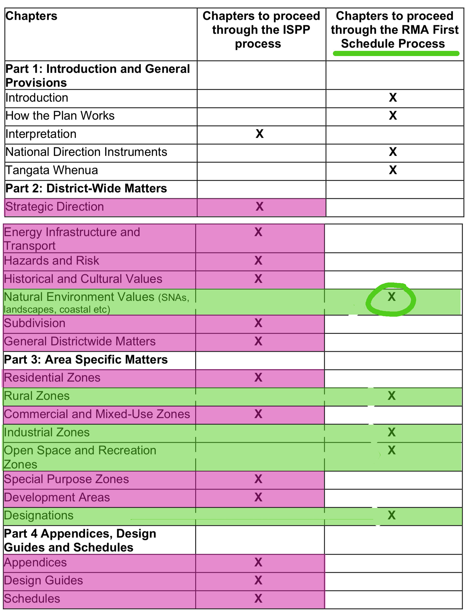
Post-script: Do you have any option to object to any of this? Sadly, not much, if any. The following picture tries to make it clear – anything in pink goes under the ISPP process, and that means that as a New Zealand resident, you have ZERO rights to say anything, ever. Its a fascist overlay, basically. Whereas if you have a line that is in green, and that means that, as per the more traditional track, people can comment via the RMA process. So, if you have a beef about Natural Environment, Rural Zones, Industrial Zones, Open Space and Recreation Zones, or Matters relating to Tangata Whenua, then you are in luck, and can comment. For the rest of NZ, including those that live in a Residential Zone, or a Commercial / Mixed-Use Zone, or who have any concerns about Subdivision, or Historic Matters, or Design Guides, then you have ZERO rights to comment. Does that seem fair, at all?


One thing that it is important to note, is that there are two ways that Council can debate and pass the items on this Agenda list. “Note the resolution of the 13 May 2022 Pūroro Āmua – Planning and Environment Committee to split the District Plan into those matters which will follow the Intensification Streamlined Planning Process to operative status in November 2023; and those matters which will follow a Part 1, Schedule 1, Resource Management Act 1991 decision making process to operative status.”
Essentially this means that the Council could either vote on the whole lot in one go, or they can (and I think will) put off half the items, and just vote through the other half.
13. If the PDP is approved, it would be formally notified for submissions on 18 July 2022. Anyone can make a submission on the PDP.
14. Hearings will start in early 2023. Decisions on the Intensification Streamlined Planning Process (ISPP) parts of the PDP (intensification areas, qualifying matters, and MDRS) must be issued no later than November 2023. There are no appeals on these parts.
15. The rest of the PDP, which follows the standard Schedule 1 Part 1 RMA decision making process, must be issued no later than July 2024. Only decisions on those parts of the PDP can be appealed to the Environment Court.
16. The Spatial Plan and District Plan Review have been running in parallel with the Let’s Get Wellington Moving (LGWM) programme. LGWM is a set of transport-led city- shaping initiatives, including mass rapid transit (MRT). Once the MRT route and station locations are confirmed, district plan changes will likely be needed to enable the higher density, mixed use developments near MRT stations.
Whooah! You’re back and with more sub-clauses than I can digest on a pre-holiday afternoon. I’ll try again after sundown. Meanwhile, you might want to avoid reading this…
https://www.stuff.co.nz/opinion/129038638/there-goes-the-sun–welcome-to-shady-city
Hooray ! How did you find that I was back online Starkive? Did you miss me? Do you check twice a day to see if I’m awake?
The outlook spaces are defined by the MDRS aren’t they? It’s a real shame govt still hasn’t taken planning completely off council. The process is byzantine and ridiculous.