Today, a guest post from Art Vandelay, with a potential solution for the route of a Light Rail system through Wellington.
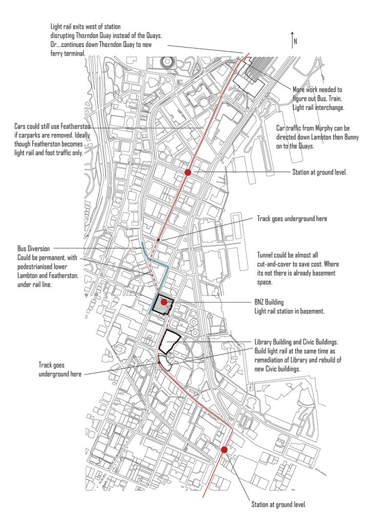
Art Vandelay states: “With regards to the columns and structure there seems to be decent spans and I’m sure some clever engineering could make it work. People will say it’s too expensive but I think we have a bad habit in this country of doing things half-heartedly to save costs, then realise 40, 50, 60 years later that it wasn’t up to scratch or it’s no longer fit for purpose. Karo drive is a good example in my opinion (the bypass that doesn’t bypass anything), and a more recent example is the Kapiti expressway (which barely lasted a year). We should be designing and planning for the next hundred years, not ten.”
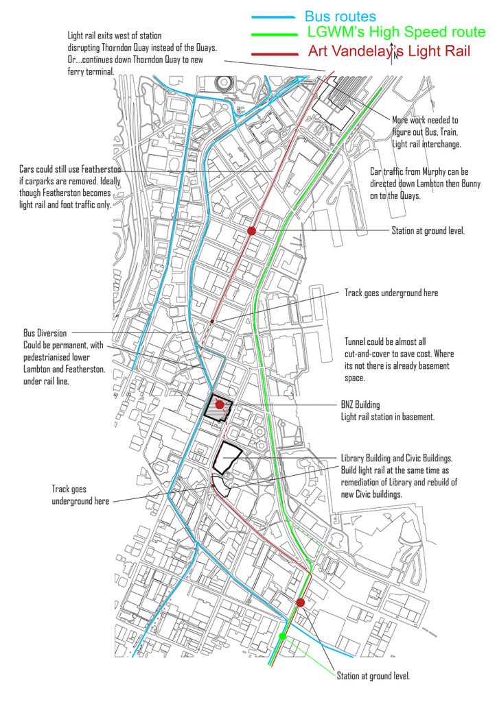
Nemo notes: Nice plan, thanks Art. Just to add to the proposal (hope you don’t mind Art), here is your version with 2 added lines: the current / proposed Bus Priority route that LGWM have put forward (all buses in blue), and then an additional line in green showing what I can only presume is the LGWM route for what may one day be Light Rail. Exactly where it goes I’m not too sure, as LGWM have been largely unforthcoming, but I gather it is something like this. Clearly there will be some clash points wherever it goes. The key is, I guess, to try and minimise them. Of course, what this also really needs to show is route for bicycles, scooters, pedestrians, and of course, where all the cars go. Hmmm. Minimising the clash points is going to be tricky… which is probably one reason why Art suggests going underground at Windy Point…
Your comments and feedback, welcome below…
Reminds me that this had been brought up a wile back – by a writer on the Talk Wellington website. Very similar diagram – so I found it and thought that I would post it up here too.
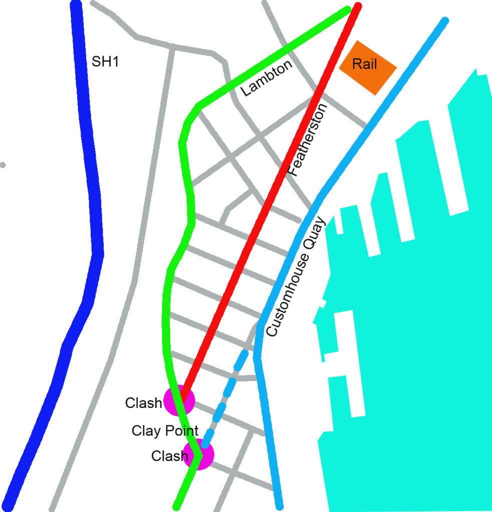

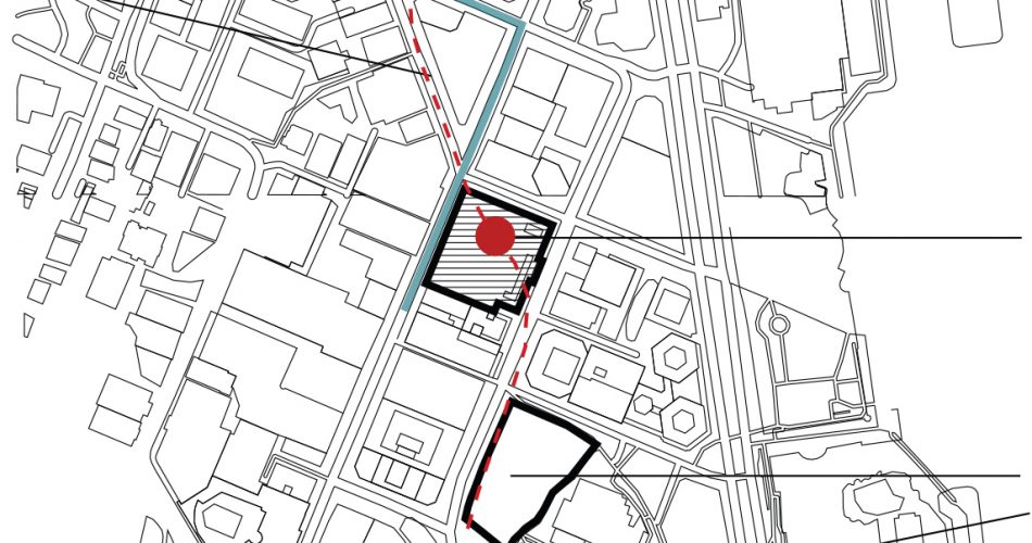

I’ll add some notes for context here as well.
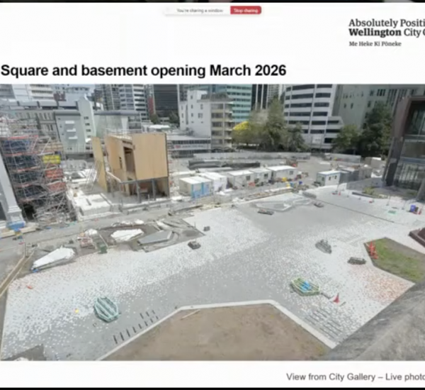
Firstly, this post came from a discussion about the basement of the old BNZ building’s (the Darth Vader Pencil case one) basement level.
I thought of this idea because I always saw the terrible food court downstairs in such a central location as a waste of space. Now the place is closed I saw an opportunity to develop that space. Following the discussion around the rail line on both this blog and the wellington.scoop website I thought neither the Quays or Lambton were really ideal, why not Featherston?
Lambton should be pedestrianized and keep the buses. In terms of the Quays, I agree with what Jan Gehl said about Jervois Quay Separating the city from the water (https://wellington.govt.nz/-/media/property-rates-and-building/urban-development/files/gehl05c.pdf?la=en&hash=AEB7C982BDDEB0B76FD2E58185183D1BCFFA7922).
If we put the light rail line down there it may be harder to break up the separation and enhance the connections between city and harbour.
Featherston Street could be more easily closed for construction, being a less important thoroughfare.
The line shown on the map doesn’t have any sharp turns except from Wakefield into Taranaki speeding up the line, which is also crucial.
Yeah, my proposal is expensive, because of the underground section. It is however good timing considering all the development that is, or needs to happen in the next few years directly on the proposed route. When considering cost, we must take into account the cost to productivity of thousands of people sitting on the motorway in their cars everyday. We need to do this line once and do it right, perhaps the current owner of the building would contribute? Having a light rail station in the basement of your building surely would increase the rents?
So why not Featherston Street?
I’m sure you will all tell me why not, but I’d still love to hear any feedback and criticism.
Finally, I have got a preference for the remaining part on the line out to the airport. If Nemo and anyone else is at all interested, I will draw that up on another day.
Thanks,
Art
Interesting thought, although I think we might be getting ahead of ourselves…
Its clear that the “street car” version of light rail is favoured by the Greens, but recent comments about seem to point to Labour being more inclined to a “light metro” solution for Auckland….
Whether this then filters through to Wellington is unclear,
But what is clear is the LGWM will not be anywhere near any light rail construction by the originally indicated 2024 timetable
Heck the next big thing on their schedule is more consultation on the Golden Mile and Thorndon quay projects….
MORE consultation? Haven’t we had enough already?
I actually think it’s high time we consulted on the amount of consultation going on.
It seems our paths have crossed – you’ve been commenting Art, while I’ve been updating the post. Thought it might be interesting to have some context. And, Yes, I’d definitely be interested to see what you would propose as a route for the remaining part out to the airport. My predecessor Leviathan took a keen interest in that discussion – there are posts from Levi somewhere on this blog about the possibilities.
I did read with interest the posts Levi has written in the past, at the time I didn’t feel like I had much to add, it was a very robust and detailed debate. I think perhaps it settled in a similar place this post is heading….
We are all very interested in the design, but until someone confirms an actual mass transit line, as Butterbee says below, ‘it’s just dreams, and lines on maps’.
Interesting proposal! A minor comment on Nemo’s additions to the map: there are also buses, from Brooklyn etc, heading north along the full length of Willis St.
As greenwelly says, there’s consultation to come (scheduled for this month…) on LGWM’s mass transit proposals, which will include the route through the city and out to the east (not just to the airport – that location was just a placeholder in the Ngauranga to Airport corridor study that begat LGWM. While the airport may have been the single biggest traffic generator in the east, as LGWM has subsequently recognised it is more important to serve the Miramar peninsula well than to focus on the airport). LGWM”s preferred route (it’s online somewhere!) runs Taranaki St-Pukeahu-Adelaide Rd-Newtown-Zoo-new tunnel-Kilbirnie- Rongotai Rd-Cobham Dr-Miramar cutting-Hobart St-airport, but this is not yet firm.
Up till now the focus for the mass transit route has generally focussed on either the Golden Mile (that’s where people want to get to and from), or the Quays (that’s seen as providing a faster vehicle journey time). Featherston St may have the benefits of both, or the disadvantages of both. There’s also the “streetcar” versus “light metro” issue that appears to be playing out in Auckland.
My view is that maximising the catchment area is important, and running along a waterside route away from the CBD makes little sense – shorter in-vehicle time will be offset by taking longer to get to/from the stops (which will tend to make it less attractive). Featherston St would be better than the Quays on this, but not as good as Lambton Quay, and Art’s proposal does address the thorny issue of getting past the Old Bank bottleneck. Items to think about here are the depths of building foundations and where the portals go – they will take up a lot of space.
As for light metro, that model currently requires full segregation, not even any level crossings, i.e. in built-up areas the whole route elevated or in tunnel. I can’t see that as a goer in Wellington.
But before we delve into the minutiae of routing, the principle of proper mass transit has yet to be adopted, which is why the next consultation will be so important. Until that happens, it’s just dreams, and lines on maps.
Thanks Betterbee – yes, it makes a lot of sense – this route was looked at early on at Talk Wellington https://talkwellington.org.nz/2017/lambton-the-golden-smile/
The author noted that:
“First up, we have the Golden Mile, the ring of almost continuous shops that circle Wellington from Parliament down to the Embassy, starting off with our former beachside main street, the once nautical goods yard of Lambton Quay. The great thing about Lambton Quay is that in terms of pedestrian flow it is essentially one sided. Nowhere else in New Zealand, possibly nowhere else in the world is there a flow so uninterrupted as the west side of Lambton.
The continuous stretch of footpath is uninterrupted by cross roads except for the two tiny interventions of Farmers Lane and Woodward Street, all the way from the bottom of Bowen Street right round to the corner of Boulcott and Willis. In public thoroughfare terms, that’s impressive.
That also means that with the almost total absence of crossings, it is a really good place to run public transport, and we’ve done exactly that for the past 150 odd years. Traffic can run unhindered by side streets, and that enables traffic to run relatively freely, not having to stop at traffic lights like Queen Street does in Auckland. The west side of the street always runs a little smoother than the east side, as the east side has to cope with vehicles turning off into Panama, Brandon, etc. The pedestrians know this and so the foot counts on the west side of the street are far higher than those on the eastern side, and rents are correspondingly higher. It makes Lambton Quay the simplest choice for public transport.
But is there another route available for us to use? Does traffic really HAVE to go down Lambton Quay? Actually, you could almost say we are spoiled for choice. If we don’t want to use the curvaceous shape of Lambton Quay, we have another Quay available to use – a straighter option. The great advantage of being a harbourside city of course means that we have another option with virtually no side roads – the route made up of Waterloo Quay, Customhouse Quay and Jervois Quay. There are only some small, rarely used traffic crossovers – into the carparks at TSB Arena, Te Wellington Museum, Te Papa, etc. It is a really valid route, easily implemented, on an already wide road, but it is furthest from where the people are, walking down Lambton Quay. So, less convenient for pedestrians, but really good for uninterrupted high speed public transport!
There is also another route we could use – straight down the middle of Featherston Street. On the face of it, it’s not such a good choice. It is crossed over by numerous small side streets like Johnstone, Brandon, Panama and Waring Taylor, which interrupt the route and could slow it down. But it is perfectly aligned from one side of the Railway Station, right down to the awkward intersection with Lambton Quay. It has a lot going for it as a prime PT route. It could be made over completely for public transport, leaving cars on the Quays and pedestrians on the Golden Mile. So – which route to take?”
The key problem with Featherston St, is that it crosses all the side streets. You can argue, as the excerpt from Talk Wellington does above, that Lambton Quay has almost no vehicle crossings to deal with – the roads are all off the other side. You can also argue the same for the Quays – hard up against the Outside lane of the Quays, there us nothing for a LR to crash into – no junctions to contend with (just workers desperate to get to the waterfront for a nice spot of sunlight).
But Featherston St as a route will cross every single one of those pedestrian / vehicular cross-over points, and potentially cause a crash at every one of those. That’s the biggest problem.
Nemo, that is interesting that Talk Wellington have discussed Featherston as a realistic option as well, thanks for pointing that out. Bugbear makes a good point about all the intersections somewhat ‘ruining’ Featherston Street as an option, and he’s right. Realistically the only way it would work is if most of those streets become pedestrianized with maybe two crossing the line?
You might say, that is a lot of streets blocked off to cars…I would ask, what are those streets used for anyway? Parking, yes. Driving around the block looking for parking, yes. Deliveries, yes. Pedestrians, definitely. Could we afford to lose them, I’m not sure, we could trial it? What if we close car traffic to Featherston and the side streets for a month. Let deliveries and pedestrians have a field day.
I’m not sure what would happen, but it would be interesting…..
And that gets to the point I really want to make. Streets are places to move people, streets are FOR PEOPLE. We always ask where the cars will go, but why do they have priority? I think its ingrained in our culture and its going to be hard to convince people there are other ways. I actually think the council and LGWM are trying, and I think they can do a much better job….rant over, I realize I’m probably preaching to the converted on this site….
Oh, one more thing I wanted to mention. Those areas on my map where the rail line goes underground. Does anyone know if that area needs all its pipes replaced? I assume they do, because……you know,
under-investment.
If so, does that make it easier and cheaper? Or does the complexity of doing the pipes and rail together make doing them separately more viable?
We can probably presume that in reality, most of Wellington needs its pipes replaced. Actually, in answer to your question, I think that replacing pipes in a large hole is probably very tricky. Much easier if they can dig a trench, lay new pipe, and back-fill – rather than try and retain pipes floating in mid-air for months or years while they did a large hole for a rail line…
Cycleway from Petone has been approved
Indeed it has. Reckon it’s feasible? The chosen method is, I think, shitloads of rocks pulled from a quarry somewhere. Personally, I feel that NZTA really need to sort out where the Quarry is and how they get the rocks to and from site, before going too much further.
Not sure what this has got to do with Art’s proposal, but read all about it at https://www.epa.govt.nz/assets/Uploads/Documents/Fast-track-consenting/Te-Ara-Tupua/Te_Ara_Tupua_Final_Decision.pdf
Fascinating, thanks Betterbee. Mentions just about everything except: where do they get the rock?
The source of the rock may well be identified somewhere in the application documentation, Nemo. Fancy a wade through?
I’ve been looking – bloody big document ! But no, it seems that wasn’t the question – so they didn’t answer it.
There was a thread on this very site about where they get the rock for this and the answer is to barge it in as boulders as the shatterzone greywacke above the motorway is just pebbles when you want rocks
I thought it was an idea at the time but Mayor Foster pointed out that barges of rocks were the order of the day so fair point
Also, search “split barge” after an artificial reef got put in near Napier recently I looked at what these are and they are rather cool
Maybe Limestone from Nelson?
There is no specification about where the Rock is coming from,
(I guess because they have not yet gone out to tender for a contractor yet)
The delivery method is also open to the contractor, there is mention of by road (either via the new access bridge at Ngauranga or Petone) or delivering them by rail (that would only really be useful if they were coming from somewhere north of Wellington)
or Possibly Barging- assuming it came from the SI somewhere, –
I think this thing is going go cost well north of $100 million ( the last estimate was ~$70m , but that was in 2019) , so lets see what the final price is….
The biggest gripe I have is that they are not planning on any toilets along the path, ( probably because running sewage pipes along the route would be a million dollar job)