Let’s not pussyfoot around – Wellington needs a Rapid Transit system and that simply cannot be more buses. And it needs to be Rapid (like the name suggests) so it needs some new direct routes – that means new tunnels. Yes, plural: Tunnels.
Dame Kerry Prendergast was wrong, like many people with limited vision of her era, in that she is seeing Wellington in the past, not the future. She thinks – and stated – that Wellington’s answer to its traffic problems is more buses. And that is simply wrong. Remember when another Mayor, Dame Celia Wade-Brown, commissioned a study into Wellington’s transport, and the answer was: Bus Rapid Transit. So that has been the answer for the past ten years or so. And have you noticed anything get better? More buses? Less traffic? No more congestion? No, I didn’t think so either.
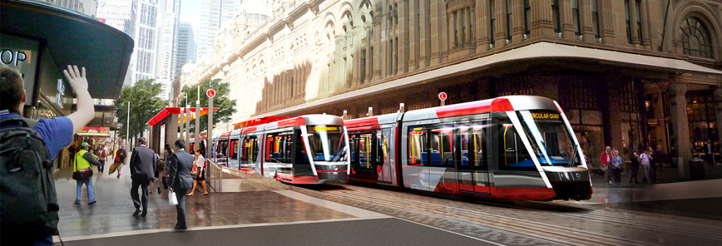
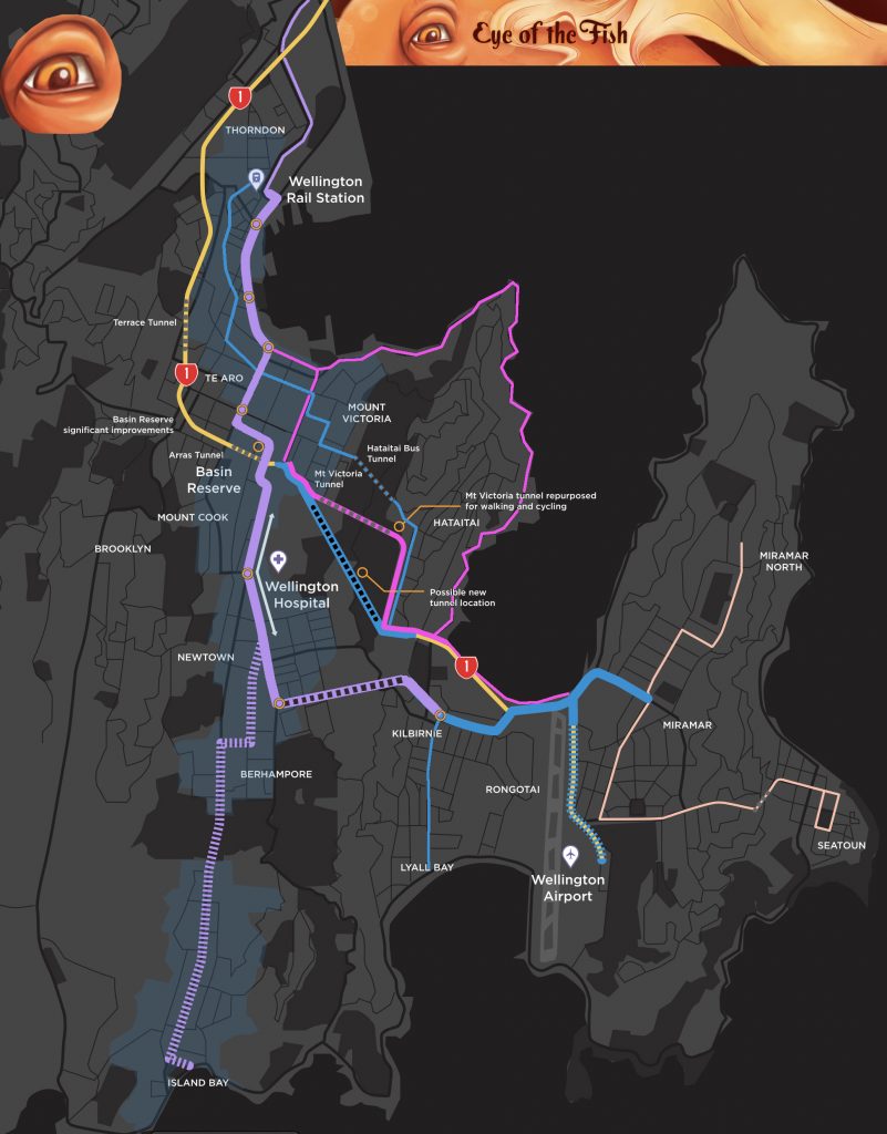
Buses simply cannot transport enough people quickly enough, to satisfy the needs of our main transport spine, even at present, let alone when we have another 30,000 people living on a spine route down to Island Bay. The answer is quite simple really – we need bigger vehicles, safely running on smooth paths, powered by electricity, and the only answer is a modern tram system like Light Rail. We need them to take the main strain of the main route, and other feeder transport methods, like buses, can link into them. Yes, we are still going to have lots of buses, as well, but they cannot be the main answer. Firstly, we establish the Cycling Network, fully, as shown in pink below.
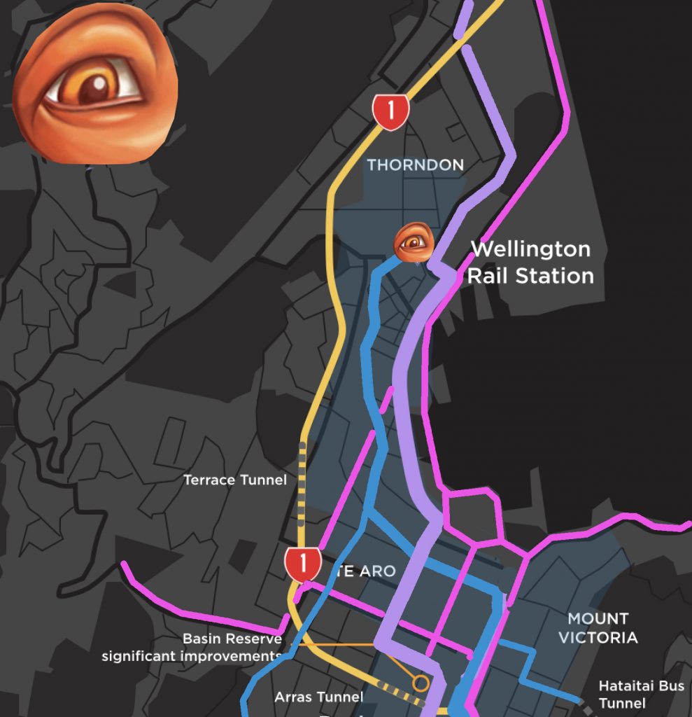
So at long last we have some Light Rail choices to discuss and vote for. Ignore Option 2 with buses – don’t even go there. But LGWM have not really broken things down in a very clear way. To my mind, with my Eye of the Fish brain, we need to think about things a little differently. Firstly, from the Railway Station to the Basin. Secondly, around the Basin and out the other side. Thirdly, tunnels under the Mountain.

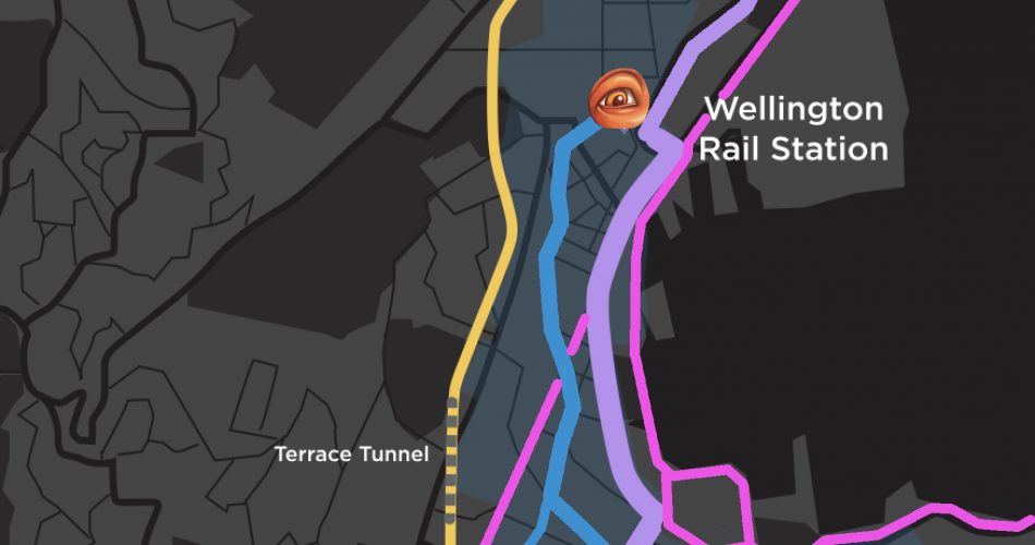
Firstly: like Erentz, a new (old, returned) writer on Eye of the Fish, i think that the major stumbling block with Wellington’s transport system is that we have this ridiculous situation of all our trains stopping on the edge of the city. We need some continuity between the systems, and with Johnsonville growing in height to become what it has always wanted to be: a destination in itself, then the logical thing to do is to convert the Johnsonville line to Light Rail and to continue it through the city.
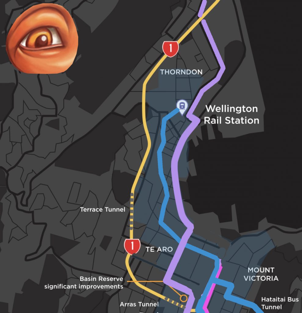
Personally, unlike Erentz, I would run rail lines down the Quays, and keep some buses serving people on the Golden Mile of Lambton Quay, because we want lots of shoppers jumping on and off the buses, buying things in shops and going to lunch with friends. On the Quays we want less stops and more speed, with two sets of steel tracks zipping passengers at faster speeds along the waterfront and out to the airport. I see that the train tracks need to have as few crossings with cars and buses as possible, so the less congestion the better. Hence, I would probably go up Taranaki St.
The LGWM team need to take this opportunity to move the south-east-bound SH1 route away from Vivian St and put it underground alongside the north-west-bound SH1 route. Either do it now, or leave room to do it later, but if you’re going to dig a hole in the city, dig it now and get it out of the way. The more you put underground, the less problems it will cause in the future, and the more us Wellingtonians can walk and scoot and ride around our own city without all those pesky cars. Pukeahu Park was a great beginning. Now do more of that.
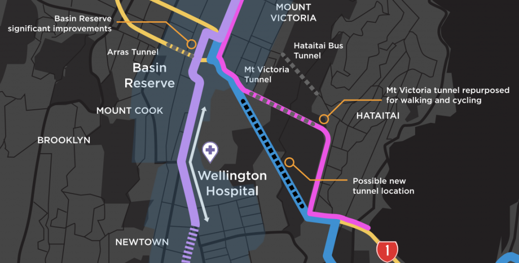
Getting round the Basin is the next step, and the LGWM team have come up with a brilliant answer – thank you David Dunlop, I knew that you could do it. The complete grade separation of north-south local cars from east-west SH1 traffic is what is required to fix the Basin traffic jam, and the adoption of the Arch Centre’s Option X solution enables that to happen with minimal fuss. It’s a simple and stylish solution that let’s the traffic move, and also gets the Light Rail through the city with minimal fuss. Then on to the big question: where to next?
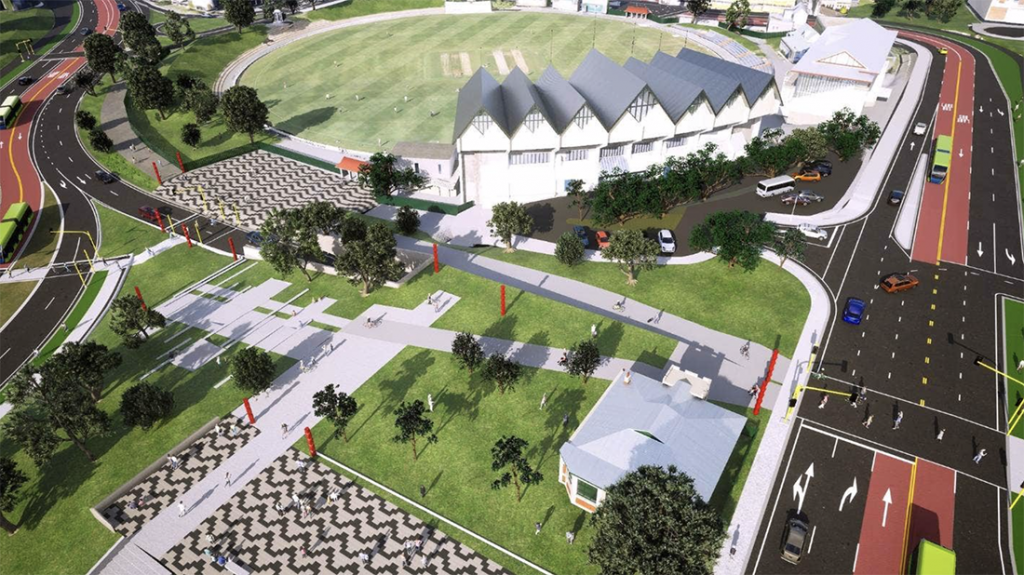
Again, personally, I think that LGWM is selling itself short by even offering options that do not have new tunnels. We have an existing tunnel under Mt Vic that was dug in the 1920s by pickaxe and with horse and cart, and was opened in the 1930s when we had about 2% of the cars on the road that we do nowadays. It is an indisputable fact of life that our existing tunnel is not fit for its existing purpose, ie that of both cars, trucks, pedestrians, and cycles. We need to dig a new, fit for purpose tunnel, and to my mind we need to dig 2 tunnels. Dig the one for Rapid Transport first, and a new road tunnel second. Why? Well two reasons, one because if you dig them in the other order we know what might happen to the other one… but secondly, because they are going to different places.
Answer me this question: who or what is the largest employer south of the Parliament?
Yes, the correct answer is: the Hospital. And the nurses and the people visiting patients are having problems parking at present. Clearly the answer is to take the mass transit, the Rapid Transit, the Light Rail, PAST the Hospital. That has to be the only logical conclusion and I defy anyone to say otherwise.
And then where? As we all know, the team at LGWM have had a change of heart about the airport and Miramar, instead plumbing for the Island Bay. My feeling is: why not both? One of the key issues for the design of any transit system is “Where are you going to keep the vehicles?” and in Island Bay there is no readily available terminal shed, or place for one. But there is in Kilbirnie – a vast, partly derelict bus shelter that take up a hectare of land or more. Its needed for buses of course, but it would also make a perfect place for an interchange as well as a train depot. Its almost beyond repair, and may have to be torn down and rebuilt, but it is the best thing we have. So in my mind, trains need to go at least as far as that. And to get there, they have to go past the Hospital and then off to Kilbirnie, under the hill. Here you go:
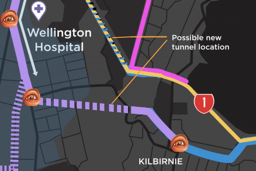
Done? The advantage of this is that it sorts out the cars from the Light Rail, for once and for all. It solves the storage problem at the southern end, and leaves the routes open for buses to connect or for more Light Rail in the future. But for me, this is the minimum that LR needs to do to get major uptake from all the population. Its a winner ! Feel free to reference this in your submission to LGWM, closing in just 2 weeks….



Changing the Johnsonville line to light rail is a Quixotic dream,
To make it work you would need to spend $100s of million, even billions to double track the line to allow services at a frequency greater than 15 minutes .
If you simply replaced the Matangis with light rail capacity would fall from around 1100 per service on a 6 car Matangi to around 900 on a 120meter light rail set,
Then you get the problem of running 120 meter long light rail sets through wellington streeta,
A single set would stretch from the far end of midland park all the way to the other end of the David Jones block…
plus you have the Real Politik of Kiwrail owning the railway line and they appear to have been specifically excluded from LGWM.
Fair comment, but I disagree. Whatever we run through the streets, needs to be able to be run further than the Wellington Railway Station. Its the massive step change that is the problem. We need overlap between the 2 systems. The Johnsonville Line never has 1100 people per service anyway – if it does, then it is working far better than when I last took it about 3 months ago.
I’m presuming a 3 car LR set to start with, every ten minutes through the city. If that needs to change to only 20 or 30 mins to J’Ville, then so be it, for that section – not every service needs to go all the way.
The morning peak trains were nearly full up by the end pre-pandemic and probably a little less so at present. I don’t know how many people that is, but a drop in capacity would be bad (especially when density is increasing around it precisely because the line is there…).
I would love to see light rail through that route, but it really would require more double-tracking to let services pass at more places to keep frequency up. The other issue is the construction: presumably all the track would need replacing with whatever the LR gauge was? For a lot of the intermediate points (not Johnsonville itself) that route is the only real PT and knocking it out for even a few months to do that work would be impractical.
It would be nice if LGWM did focus a little more broadly and in a linked-up way on movement in Wellington that didn’t involve the Basin Reserve.
Gauge does not need to change. NZ has one gauge throughout its network – there would be no changes anywhere.
Look: I agree with you that J’Ville Line is not ideal, but the really really REALLY important thing is that there is some way of getting rail out of the present impasse of “All Change Please” that happens. That is the major issue. Happy to hear any alternative proposals.
Why do people hate so much on a mode change at Bunny St?
Mode changes can and should be pleasant experiences with as much or as little time as you like between connections, and lots of opportunities to do useful nice stuff if you choose to spend longer in the mode-change spot. Think Victoria in London, or frankly any half-decent metropolitan station. (Ōtautahi is getting there, bless it – it’s got good bones).
But seriously, all the obsession with getting a single light rail line running from Jville to the south coast is essentially “four trains to the planes”: it rhymes, it looks nice to draw a big swoosh on a map, but it’s daft. It’s getting tunnel vision for A Big Build Project when we can achieve the same good transport and city-building outcomes with less dramatic, cheaper, faster, and more nuanced combinations of investments and tweaks.
There’s no fundamental need for taking people at pace in the same vehicle from Jville to Island Bay. And it invokes all sorts of silliness like haemorrhaging public money into double-tracking in one of the slippiest, most precipitous bits of landscape this city has. Not to mention extra tunnels.
Yeah, nah.
Mr Welly, I think that both you and Mr KiwiRail need to look at the bigger picture, not be constrained by current ownership. If that line is needed for LGWM to succeed then that is what should be done. Rail lines swap ownership all the time elsewhere in the world. Deutschbahn now run a large amount of what used to be British Rail. The French own / run the NZ services in Auckland and Wellington.
The big question for me would be: how do you get the J’ville line to swap over from left side to the right side?
Maybe you don’t need to swap Alan. I think I’m still with erentz about the light rail down the golden mile. Keep the line on the western side, no need to coss over.
Nemo, do you know how much time the train saves going down the quays? And if it’s only 5min or so does it really matter to the user? From my experience the metric of convenience can be just as, or even more important. We need to capture as many people as possible and the golden mile does that better. I also think that the golden mile would be a much nicer place with trains going down it than all the buses that currently zoom down there.
Apart from that I pretty much align with all of how your submission is coming along.
One more question though. Why did you decide to create the tunnel from Constable and Riddiford to Kilbirnie, and not the original route past the Zoo?
I agree – if J’ville can justify a heavy line then it should stay a heavy line.
I would extend the J’ville line and reconnect it back to the main line at Tawa though, so it becomes a suburban-linking line through to P-town instead of a dead end AM in / PM out commuter line. If you want to go from Khandallah to Porirua you could then take the train. Leaving aside whether anyone from Khandallah would ever want to go to Porirua, has this actually been considered?
And extend Melling to Manor Park to allow better connections? (And a through route for Masterton trains)?
Or have we given up on rail completely?
I’ve got friends who go from Khandallah to Porirua about 5 times a week – and at the moment it requires them to go (if by train) back into town, change lines, and then out to Porirua. It is a process that takes so long (not arduous, just lengthy) that they nearly always take the car instead.
All good suggestions Señor Chico – but possibly outside the scope of the LGWM consultation?
Good questions Pedge – I’ll answer the last point first. I’m just putting it out generally that the line needs to go past the Hospital, so I don’t really mind where it goes through to the other side. But I am aware that generally, the township of New seems to get very built up and clogged up and is probably a nightmare to get through. I would like to get to the Zoo, but it would need a lot more people to make it financially viable to get there. I guess that is what it would enable !
Re the Golden Mile vs the Quays, I don’t really mind too much which route, but my thinking is that if they were serious about the word “Rapid” then the Quays would be a better route. One stop at Wellington Railway Station, one stop at Queens Wharf, one stop at Te Papa, that sort of thing. Whisk people along speedily, which is what we really want, isn’t it? If you go up the Golden Mile then you are always going to have masses of people around, harder to control then and go fast, with more stops requested, and so any transport system up the GM is always going to be slower, unless they do an overhead monorail. Which they are NOT, before you start singing that Simpsons song to me….
Haha, one of the very best Simpson episodes.
All fair points. My thinking about a light rail line is if it’s at ground level, it’s taking up space and it’s slower than a metro, lean into those and make them benefits. Make it run right down where the people are, make it sexy, make it convenient, easy, tourist firendly. I’m really not sure how fast a tram could travel down Willis or Riddiford for example, ill try and find out.
I can imagine Riddiford street being pedestrianized as well as the golden mile, without upsetting too many businesses. Looking at Google maps Maccas is the only one that currently has decent parking (and who cares about them). Traffic would get routed up Mein, then Daniel. The idea of a rail line is it should dramatically reduce traffic, especially along roads like Constable because it just links two suburbs. This plan would ideally make Newtown a bit of a destination, more pubs, restaurants, maybe a decent music venue (I don’t really care that much about the zoo, we want people using the train day and night).
Even the Newtown Residents Association support density along the main street.
What do you think?
I’d better ask the Newtown Residents for their input then !
The depot is sold https://www.nzherald.co.nz/nz/latest-wellington-bus-headache-infratil-sells-kilbirnie-bus-depot-for-35m/WKSSYYA2FEJ7AHMELUYL46KXWM/
Though I fully agree that going east should be the initial priority for Light Rail.
Oh good grief! How could the Regional Council be so stupid as to let that one go ! As the NZHerald says (and thank you for that Conor).
“The depot is a strategic asset for the services NZ Bus runs in the east of the city.” Well, its not a show stopper for my plans,. but it certainly is a problem for the Regional Council and everyone else in LGWM !
They’ll need to find an alternative depot site regardless, whether they have LR or buses. But GW should have had a better control over the sales that Infratil made. GW are clearly not the best deal-makers in the world….
No doubt there will be some people that think I should just shut up and stop causing “trouble” – but I hope that y’all can see that what I am trying to do is encourage thinking, debating, discussion, and evaluating – rather than just blindly saying yes to everything.
More to come !
Hey Nemo!
Good on you for creating a debate!! It’s necessary and very interesting!!
I am interested in your views around that MRT spine going down Island Bay when it was assumed, for as long as LGWM has been consulting (so pre-dinosaurs really), it would go to the airport. It came as a shock to me: while I’d do nothing to help the growth of this monster, I’d love the traffic to the East to be smoother, for Eastern suburb residents’ sake. Instead, it seems the East is just an economic chest to be riped from its benefits, at the minimum cost to the city: let’s get MRT to Island Bay and give the East the buses (electric, if we are lucky! Remember that we have the +30yo diesel buses at the moment)!
So anyway, keen to hear your thoughts.
Bummer, man how’d I fail to convince you that LRT should be on the Golden Mile :-)
I think the time savings aspect is small, I might try model it later, but in the ianwallis report it mentioned something on the order of a couple of minutes. If the majority of people are destined to the Golden Mile, then you have to account for that and the extra time people will have to spend walking the ~200-300 meters they’ll have to walk to it. Assume 50% going to the left and 50% to the right, the average person is still going to something centered roughly on the GM. ~250 meters at 1.35m/s is 335 seconds. So an extra 5.5 minutes of walking for the average person from the Quays route, not including the extra intersections that need to be crossed and waiting times to those. It’s a really significant barrier.
Spot on about the Vivian St traffic sewer. It aint going to happen in this programme though sadly. I hope they’ll leave allowances/consideration in their design for it in future. Wellington really screwed up not extending Ghuznee and Abel Smith when they had the chance. Allow so many more options today.
Couple other thoughts, regarding stabling of trams in the east check out the area around the very eastern end of Rongotai Rd (the old Rongotai Rd stub beyond Troy St) there’s heaps of room for a new depot there, easily connected to the line.
Also, thoughts on tunnels under Berhampore? It adds a lot of expense, but it’s an option now or could be done in future. If your line is running down Riddiford and Mansfield, through to Newtown Park, it turns east behind the Stadium to a stop and tunnel to Kilbirnie. You can also fork and turn west into the hillside, under Berhampore. to one underground stop in Berhampore before exiting back to surface running next to Wakefield park.
Totally agree with pedge about pedestrianizing Riddiford Street, essential IMO, will prove to be a great area with intensification (I can’t believe how crap Newtown still is, it has barely changed in 20 years, we really haven’t allowed anything to develop in Welly have we). Newtown being sold short in LGWM plans.
Who really cares what a former mayor thinks? Prendergastly was always ideologically opposed to rail (She tried to convert the Johnsonville Line to a busway at one point) and there is ample evidence available to debunk her anti rail propoganda. Also a small detail on Johnsonville Line trains, they are limited to four cars not six.
Agreed Luke. I think that if Kerry had ever actually gone up the J’Ville Line, at least once in her life, she would have seen that you can’t stuff a bus through those skinny tunnels…
In my view the guided bus way was an idea with potential. I believe there is one in Adelaide. The Jhnsonville train line is essentially a commuter service subject to peak demand. The bus way proposed city bound buses one after the other to the CBD in the morning returning against traffic on the road, rejoining at Johnsonville then changing direction in the afternoon. I thought the plan made a great deal of sense. As other commenters have said unless the Johnsonville Line continues through to Porirua then it’s useless for anything other than commuting to the CBD. I am equidistant from the bus and the train and I would choose the bus every time. Faster, more frequent and gets me further into the city.
There are two points missing in your review
1) Cost: Who is paying for this? Wellington cannot afford it. So we need the government. As soon as National is back in power any money for this will be stopped (and that is assuming that Labour would not stop it but support it). So none of these options will ever be realized.
2) Timeframe: This is supposed to start in 2028 and finished sometime in the 2040s. Wellington Council has stated that they want to reduce emissions by 57% by 2030! Since our big emissions are transport and waste, transport has to reduce emissions massively by 2030. Nothing of this will help with that. Even worse, a third of all bike lanes are attached to this project now as well, and hence mode-shift to biking will also be delayed to sometime in the 2030s (if some parts finish early, hah, whom are we kidding) or 2040s.
In my submission I rejected all four options as insufficient. If LGWM cannot provide a Public Transport solution to mode-shift people from cars into PT then we have to invest massively into biking and walking. It might be an idea to spend 6 billion on buying eBikes for every Wellingtonian. That could provide some mode-shift (of course you still need a place to bike and without a tunnel Kilbirnie and Miramar are a wasteland for active modes).
P.S.
My preferred SH1 solution is to terminate SH1 at the Wellington city limits. If there is no highway going through our town then there is no problem.
P.P.S.
In fact we might have to turn around 180 degrees and perhaps declare every road in the city off limits to private cars and then add some lanes for private cars to some roads (instead of adding some bike lanes or bus lanes to some roads). Unless we are not serious about going net-zero by 2050.
Agree the costs deserve to some stern looks. It’s time for a royal inquiry into infrastructure costs, we get so much less for our dollar every year and it seems to be fast outpacing wider inflation rates. What’s going on, is this just a misperception I have? At this rate by 2050 we’ll be able to repave 1 meter of road a year and have to make do with that. Not a unique NZ problem, seems to be exactly the same in AU, CA, US, UK also. Can we just hire the Spanish to build our infra for us?? At their costs we’d probably be able use the same budget to get a metro line from Thorndon to the Airport (really not much of an exaggeration).
And I don’t know why bike lanes are so hard in this city. Time for some guerilla road marking crews. A lot of the pedestrian and cycle improvements could be done on the cheap, quickly, tactically over the next year. It’s paint. It’s planters. Maybe some bollards. See what works. Iterate. Make permanent when ready and have the money.
Can this post be summarised as supporting Option 4 to the hospital, but with preference to head east as the next phase after that? I thin Option 4 as much of what you describe here – the quays and Taranaki street.
Given that all the diagrams are based on Option 1, then I’m not sure how it appears to you to be based on Option 4, – but basically, the LGWM group have broken down their scheme into a mix and match – I’ve just changed a few things on their list of options.
I thought the big difference for light rail between 1 and 4 was Kent and Cambridge (option 1) vs Taranaki (option 4)
To me the big difference is the position / plans for digging under the mountain – and also that the Basin is not treated in Option 4. To me, that’s crucial. Got to get the Basin sorted with all this, or there is no point in doing any of it. Option 1 sorts the Basin – whereas Option 4 does not.
Have to agree with going east before south.
There’s little scope for intensification beyond Berhampore. The good people of Island Bay won’t knock down their leafy villas. Kilbirnie and Rongotai are less, say we say, maintained.
They said that going east is no good from a resilience perspective, which is obviously nonsense as they’ve put the line along the waterfront in town. They’re actually nuts.
They should go east first, and then do a spur to Island Bay at the same time as they do a spur to Karori (given that practically the same considerations apply to the Big K as they do to IB).
I wish people would shut up about the zoo though. No one wants to go to the damned zoo.
Señor Chico – take your kids to the Zoo ! They’ll love you for it.
I don’t think it’s quite that the Zoo is important. It’s that if you go near there, you get all of Newtown plus some of Berhampore in a 10 or 15 minute walking catchment, then a shorter tunnel than what is is the options to head east now gets you straight to Kilbirnie.
Absolutely, yes.
Getting through / over / under the hill to Berhampore and its skinny road system is always going to be a tricky thing, no matter where you go…
They do… but then they feel sad at the trapped animals, and require the purchasing of soft toys to cheer them up. :)
But what I really meant is that the zoo itself is probably not a big driver of traffic and is well back from the big drivers of the Hospital and central Newtown. Heading east from the Hospital and south along Rintoul? might be better metro routes and we shouldn’t necessarily change those routes to provide access to the zoo (accepting of course that outside the zoo might be a grand place for a transfer for the southern hill bus routes – but that’s a different issue).
The big problem that I see with going down the Adelaide Road towards Berhampore and Island Bay, is the route – no idea how they are going to get there – obviously some other street! It’s so narrow – even two cars passing get stuck at some point. They can’t dogleg it down Whare Pouri St like they might propose with the cycle route. It could go through the park ?
I’ve just seen the comment from Erentz – sorry I had missed that, and I think you have a clearer understanding of the Berhampore issues than I do. Want to put it on a map ? Let’s get it official!
They plan on putting it in shared traffic. Another mark against going south first.
Shared traffic? I would want to see plans of how they propose to do that. Both the route, and the street width etc. I’m sure they may think they have it sorted out, but for the rest of us not in the LGWM team, we’d have a right to be very worried !
Yep, 50% of the line will be shared with traffic. Crazy IMO. But it can work if you don’t mind less reliability, speed, and want to reduce frequency. There are some areas where you could widen things a bit, maybe make a lane traffic free for citybound trains at key points, so on. Maybe they should just compulsorily acquire all of Berhampore/Island Bay and widen the streets to avenues, and redevelop the whole thing to 6 stories, then sell.
might be some pushback against that ! If people are crying out “Fascist” against the recommendation of getting a life-saving vaccine, then just imagine what people would do if their whole house / street was compulsorily acquired !
Anywhere south of Countdown and the roads are far too narrow for light rail. It won’t fit and allow any parked cars or 2-way traffic, and rails are generally inconsistent with cycle tyres… so there goes the cycleways.
Has to go east from the Hospital.
You can’t say that rail through Kilbirnie doesn’t meet resilience requirements and in the same breath put it along Customhouse Quay. That’s just embarrassing.
Have to disagree with you there Chico. Is it your assumption that the default mode is car, and any train line needs to work around that? Isn’t a road is just a place to move people. Why can’t a road, or ‘transport corridor’ if you like be switched to trains? It doesn’t have to carry both. As I mentioned above, I think we can pedestrianise Riddiford and have a train straight through the centre. Then it can go to Island Bay or east to Kilbirnie, (my preferance is east).
The cars can park in the side streets. The traffic through Newtown can easily be routed through Mein and Daniel. The council could even trial it first and see what happens. Easy as.
Agree you’ve got a point about the bike tyres, not sure how that works.
I was in Newtown yesterday, and I have to say, it was looking rather grim. There appears to be a lot of poverty and unemployment and some really bad substandard housing. The developer in me wants to say: knock all that crap down and start again. But I guess there are at least some low cost affordable houses in there? Certainly if you were to put a Light Rail route through there, it would make it a lot more desirable and would encourage redevelopment.
The question i have about running trains through Newtown and making Riddiford pedestrian friendly, is: where do the cars go? You can’t just delete their access and not expect controversy – you need to have figured out a reasonable response to the question. Those back streets and side streets are pretty chock full of cars and tiny houses.
If you are sharp of eye, you may have noticed that the pictures here have all been updated, with the LGWM logo removed and the EOTF logo added in its place. I’m delighted to say that this is because someone from LGWM contacted the Fish, and asked that their LGWM logo be removed, in case anyone mistook the Fish scheme for an official option. Happy to oblige – of course, we here at the Eye of the Fish would be more than happy for our scheme to be adopted as official policy, but in the mean time, just in case you were confused, I’ve placed a big Fish Eye on each of the ones that I have drawn on… Hope that clears up any confusion !