The business of the Basin Reserve flyover has been on my mind so I thought I’d use this guest post to question our current strategy for SH1 between The Terrace and Kilbernie. You see, the thing is I’ve just not been able to work out who is supposed to be happy with the current strategy. Of course we’ve got the motorists represented by NZTA (and half of the WCC) who want improved roads and reduced congestion. We’ve got the public transport advocates who argue we need to tackle congestion by getting more people out of cars and into improved public transport. And we have the residents, architects, and planners concerned about whether what we do damages or improves our urban environment. Only the motorists seem to be happy, but I don’t think they should be.
To recap the current strategy: it starts by grade separating east/west and north/south traffic at the Basin Reserve and widening the Inner City Bypass (ICB) to three travel lanes, continues with the duplication of the Mt Victoria Tunnel and widening of Ruahine St and Wellington Rd to four travel lanes, then concludes around 2026 with the duplication of the Terrace Tunnel. The strategy reaches a dead end at this point.
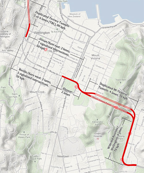
I can’t tell if this dead end is planned or not, since no one seems willing to acknowledge that there’s any problem with it. But I feel this end state is less than ideal for Wellington. From the motorists’ perspective we will clearly have a capacity imbalance across the different parts of the route, with duplicated Terrace and Mt Victoria Tunnels flowing onto congested surface streets. From the urbanists’ and residents’ perspective we’ve done serious damage to the Basin Reserve with the flyover and to Te Aro with the curvy ICB, and we’ve directed tonnes of traffic into our city (currently 60% of traffic on Vivian St and the ICB is through traffic that doesn’t belong in the city). The public transport advocates would argue that the money should be spent on long overdue public transport improvements before pouring it into new roads, but that aside, they surely can’t appreciate the suboptimal design that hinders the ability to create dedicated bus and light rail rights of way, and hinders closing Courtenay Place.
So once we reached this point, and everyone is hopefully thoroughly unhappy, if we wanted to increase capacity, or bury this traffic, what could we do?
At the Basin Reserve the only move we can make is to duplicate the flyover. We can’t change our mind in future and build a tunnel because the footprint of the tunnel and Basin Reserve flyover overlap, the level of disruption and cost would be too great to consider anything other than a duplicated flyover. These flyovers would then be directed into a new cut-and-cover tunnel constructed between the Terrace Tunnels and Basin Reserve to give us something resembling the following.
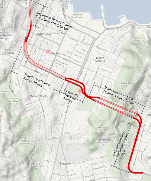
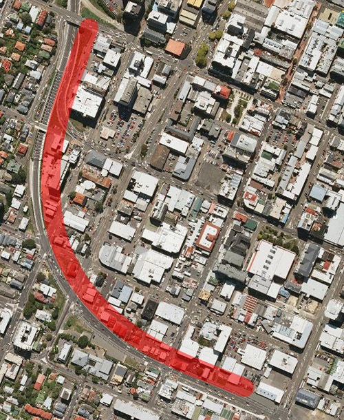
However, this will not be a very tenable proposition. Of course I doubt anyone in future will accept a duplicated flyover at the Basin Reserve. Beyond that it will mean demolishing and digging up the new Memorial Park, relocating the memorials. It will mean building the tunnel to the north of the ICB in order to avoid diverting over 20,000 vehicles per day off the ICB onto other routes such as the waterfront. This will require us to purchase a 30 meter wide swath of land, demolishing and relocating many buildings at great expense. Some of which have already been relocated during the construction of the ICB, many of which may be newly constructed in the intervening time. Many of these are significant buildings, including the dental school. These are the kinds of issues that held the ICB up for years, but on a grander scale. Here’s what a 30 meter wide swath of land means by the way.
As for cost, the current strategy, assuming we go with the lowest cost flyover option with no Memorial Park tunnel, comes to between $505-592 million before we’ve started digging a tunnel under Te Aro. That is $75-100 million for the Option A flyover[1] followed by $430-492 million for the duplicated Mt Victoria Tunnel and widened Ruahine St and Wellington Rd. Now if we then decide we want the tunnel we would be facing an additional cost in the region of $730-760 million, bringing the total cost to reach the final goal to $1,235-1,352 million. This is composed of $90-120 million for the duplicated flyover to the north (taken from Option B’s cost[1]) and $660 million for 1,100 metres of cut-and-cover tunnelling at a rate of $600 thousand per meter[4]. I’ve excluded property costs because it would be too painstaking to calculate, but this will add tens of millions also.
So who is happy with this strategy? I can’t understand it, it only makes sense if you assume that no future generation will ever want to bury SH1, pouring that traffic onto congested city streets is okay, and the urban environment can be damned. So at this point I’ll describe two alternate approaches I think we should all be seriously considering before we break any ground at the Basin Reserve.
The first is the incremental approach. Of course this approach would’ve been much easier going in the eastwards direction, but now we have to work around the ICB. This approach requires us to build a tunnel instead of a flyover at the Basin Reserve. This would be a variation of Option G[3], constructing a wider tunnel to allow future bidirectional traffic, and a stub at the western end to allow for extending the tunnel without interruption. It could also include an entrance from Kent Tce. This would probably cost something in the vicinity of $400 million. This would be followed with the Mt Victoria Tunnel duplication at $432-492 million, then the extension of the Te Aro tunnel at another $430 million.
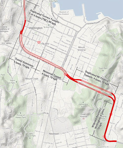
This approach carries a higher up front cost, but we do get the benefits of improved westbound traffic flow and a far superior urban design outcome for the Basin Reserve and Memorial Park. We get improved space at the Basin Reserve for dedicated PT lanes. If/when the tunnel is extended we will not have to face a duplicated flyover at the Basin Reserve, and disruption will be considerably reduced with no need to demolish the Memorial Park. The drawback is that we will need to maintain ownership and possibly acquire new property along the route of the tunnel extension.
The second approach is for us to give up on trying to shoe horn a series of ad-hoc state highway improvements into this corridor, and go for a complete solution by burying the state highway in a deep bore tunnel. This approach would provide greater long term benefits, but it’s a much bolder strategic move requiring big cajones from the politicians and planners involved. It would start with us completing improvements to the Basin Reserve to improve traffic flows without the expensive and undesirable flyover. These at-grade improvements are aimed at simplifying and streamlining traffic flows to see us through the next decade while traffic volumes are predicted to stay static or possibly decrease. It would see us forgo the duplication of the Mt Victoria Tunnel in future, and instead construct a deep bore tunnel between the Terrace Tunnels and Kilbernie to carry all SH1 traffic. Vivian St and the ICB would continue to carry traffic exiting/entering the city from the CBD, but these surface streets and the Basin Reserve will have plenty of capacity now that the SH1 through traffic removed from them.
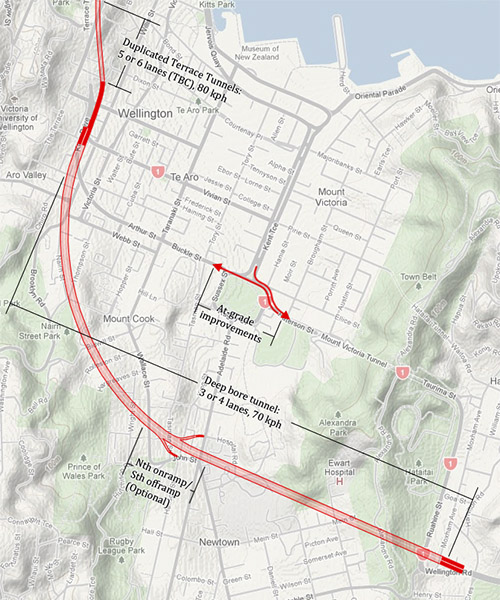
This approach would be the least disruptive, utilising TBMs to carry out most of the work under the city while day to day business carries on as usual. Ruahine St and Wellington Rd would no longer need to be widened, and Karo Dr could be removed and straightened to link Aro St with Arthur St, reestablishing the Te Aro street grid. By adopting this long term plan the city can begin to heal the scar along the existing ICB route with confidence that it’s permanent. The deep bore approach would see $40-50 million spent on at-grade improvements (a variation on Option D[1]), followed by a 3.25 km deep bore tunnel at around $1,300 million [5] for a total of around $1,350 million. Now this approach also has the added benefit that we can easily collect tolls from users because the deep bore tunnel to provide additional funding to complete the tunnel earlier.
This is where I think it’s critical we answer the question: do we want the option of putting SH1 into a tunnel in the future? I suspect many would prefer to rethink the current strategy and see one of the other approaches above adopted. Here’s how I think each of our three camps would rank these three strategies.
The motorists would prefer the incremental approach the most because it gives immediate benefits and is unlikely to be tolled. They’d prefer the deep bore approach second because it provides a faster journey. They’d prefer the current strategy the least because it is unlikely to ever result in a fully grade separated SH1.
The public transport advocates would prefer the deep bore approach the most. It doesn’t pour money into new roads and it makes simple upgrades that are sufficient for the next decade during which time they argue traffic is likely to stay static if not decrease due to the impacts of peak oil. Over this time improvements to public transport will be made and they may even find by the time comes around to build the tunnel it is no longer necessary or can be delayed. They’d prefer the incremental approach second because it allows us to have a better configuration for light rail and busses at the Basin Reserve.
The urbanists and residents would prefer the deep bore because it is the least disruptive during construction, and requires the least number of properties, does not require any flyovers, and does not widen streets. It allows the reestablishment of the street grid, and for the ICB scar to heal. They’d prefer the incremental approach second because it doesn’t require a flyover, and gives a better result for the Basin Reserve and Memorial Park, with a less disruptive upgrade path to a full tunnel in the future.
So if I’m right that puts the deep bore option ahead of the incremental option, with the current dead end strategy in last place. Why are we following this dead end strategy?
[1] Feasible Options Report, January 2011.[2] Mt Victoria to Cobham Drive Scoping Study – Technical Report Cost Estimate, May 2011.
[3] War Memorial Tunnel Scoping Report, December 2010.
[4] Pro rata rate of $600 thousand per meter was derived from the $290 million cost for Option G and increasing cost by a factor of %50 to account for additional width. Not particularly scientific, but should provide a reasonable first order approximation.
[5] The Waterview Connection in Auckland can give us some guidance to the costs of deep bored tunnels. NZTA wouldn’t reveal the estimated costs for the tunnelled section until after the tendering is complete, but we know that the project includes twin-bore 3-lane tunnels at a length of 2.5 km, with other surface sections, and widening of the Northwestern for an estimated cost of $2 billion. If we assume $1.5 billion of that is just the tunnels, and an efficiency factor of around 1.5 for boring two tunnels versus just one we get an approximate cost of $400 million per kilometre. This appears to compare well to overseas projects, such as Madrid’d M-30 project (very cool to drive through, sorry no pictures).


it is spelt Kilbirnie
Pay no attention to the spelling pedants; great inaugural post Erentz. Look forward to reading more of your thoughts.
Speaking just for myself – and not on behalf of any of the groups I may or may not represent – this is by far the best solution I’ve seen. The logic is impeccable, and I for one would be a huge advocate for making relatively cost-effective surface level changes, followed by a deep bore tunnel. And by the time we’re ready to set the tunneling machines to work, it should be clear whether the traffic modelers have prevailed over the peak oil modelers, or vice versa.
Thanks Erentz – it’s great to see such an innovative and thoughtful approach to the problem.
Interesting argument. My concern would be the seismic safety of such a large tunnel. How safe us such a large tunnel going to be in the event of an earthquake? It’s not actually on the main Wellington fault line, but surely there’d be some risk? Is that perhaps one reason why this may not already have been considered?
Heh, I’ve been spelling it with an ‘e’ all my life, only just now it gets pointed out to me.
Kent, feel free to advocate away. :)
jack, I don’t think the deep bore tunnel has been considered by NZTA, I sent them an email asking, but got no reply. Such tunnels tend to be very safe tho, of course they’re found in other earthquake prone places such as Japan, Seattle is planning on building one under it’s city, we’re going to do it in Auckland, and so on. Also I suspect the route would put it through more stable land than the cut-and-cover route (but I am not a geologist).
Great post Erentz! I’ll read anything with maps.
Both Te Aro Tunnel and the Deep Tunnel are interesting ideas. I think each would benefit from having an all-direction intersection around Victoria and Willis Streets so that west bound traffic from the eastern suburbs can exit there for the Lambton Quay end of town.
The Deep Tunnel proposal would be too far south for traffic between Te Aro and the eastern suburbs, which would still need to use the old Mt Vic tunnel. That will need some serious work to bring it up to modern standards if it is to continue to be used for vehicle traffic. The lanes are way too narrow.
Has anyone considered west-east streets in Te Aro if the main route will be tunneled? West of Taranaki St you’d have Ghuznee St, Vivian St, Abel Smith St, whatever local street is built on the current bypass route, and Webb St. East of Taranaki St you have Vivian St and nothing else because you’re going to build a park on the bypass route. That is a serious imbalance, especially if you chose the Deep Tunnel and therefore didn’t have a tunnel between C&K Terraces and Willis St. There really isn’t any other way to shoehorn an extra local street in to the grid east of Taranaki St.
Hi Erentz,
Great post -the long term approach definitely appeals. I’ve also been struggling to see who this project is designed to please or what problem it is supposed to solve. Without even considering the effects on the city/urban issues -these projects move so slowly and the so called facts on the ground move much faster (traffic volumes/demand in this part of the city, peak oil etc)
One other issue that I haven’t heard get enough airtime is the Airport. If developing long haul flights goes ahead (the airport is keen and the benefits to the city are compelling –I don’t have a link but the airport published their growth projections a while back and the mid to high projection see the airport getting a lot busier) then it should carry greater weight in directing the mode and funding of any improvements to the route. Of course in that case a dedicated PT route between the city (and further afield) and the airport is even easier to make.
I guess my biggest issue (and I live on the other side of the world now so maybe miss a few things…) is with the communication for this whole project is the lack of clear benefits linked strongly with wider urban and infrastructure planning. In this I mean linking back very strongly to growth plans in the east – giving certainty about Retail development in the east, density of housing development, location of city/regional facilities (missed that bus a little bit..) and the airport and painting a clear picture about what we want, what is achievable and in what scale and time we want/need to do this.
davidp – The existing Mt Victoria tunnel is having its systems upgraded at the moment, obviously, and the proposal from local residents is that the existing elevated pedestrian/cyclist lane should be removed, allowing the vehicle lanes to be widened. This sounds like it would address the issue you’ve raised for local traffic from Te Aro to the Eastern suburbs.
The intention would then be to refurbish the existing pilot tunnel for pedestrians and cyclists, so they also have a high-quality route through Mt Victoria, away from the fumes and noise of the cars. This becomes viable because there’s no second Mt Vic tunnel in Erentz’s proposal so the pilot tunnel would be sitting unused.
Kent, you’re more likely than me to have been thru the pilot tunnel, so I may be speaking out of hand, but it is my understanding that the pilot tunnel really isn’t big enough to function as a 2-way bike/pedestrian tunnel – it just simply is not big enough. Diameter of 2-3 m ? To be a decent bike tunnel it really needs to be at least 4m in diameter, or more.
Don’t be afraid of digging tunnels – tunnels are cool!
One goal of a tunnel should be removing traffic from the harbour quays, which would enable the city to connect more with its waterfront. The Te Aro tunnel option would seem to be a better option than a deep bore to achieve this as an entry/exit to the tunnel could be build at Kent Terrace, which would draw Western city traffic away from the waterfront onto SH1.
daivdp, re: east/west streets, what are your thoughts? If I had my way we’d plan to extend Abel Smith St all the way to Cambridge Tce, but I’m sure that’d attract a lot of opposition (Mt Cook school would need relocating for one), and it’d probably require the WCC to take an active position in acquiring and developing the adjacent land to make it feasible (mind you that may actually make the project pay for itself).
Of course without that we have what we have today, with main east/west cross valley links being Vivian and Buckle/Arthur/Karo Dr. The park would still have a road through it, it’s just under either of the tunnel proposals it’d have less traffic on it. (I don’t have a problem with that myself.) If we did extend Abel Smith St, we could put westbound traffic on that, and revert Buckle/Arther to two way traffic. Aside from those main routes WCC would be seriously negligant if it didn’t plan to extend some of the existing smaller dead end streets such as Fifeshire Ave and Barker St, I’m hoping the 2040 masterplans will see that.
SimonBK, re “linking back very strongly to growth plans in the east…giving certainty about Retail development in the east, density of housing development, location of city/regional facilities…” — I agree, I think at this point the potential for growth in the eastern suburbs has been underestimated, it definitely needs more attention by the Council to get it right.
erentz>re: east/west streets, what are your thoughts?
I’d interpreted your Deep Tunnel proposal to mean that there wouldn’t be a Te Aro Tunnel, and that the current bypass would be paved over at Mt Cook to make a park un-encumbered by a through road. Your Deep Tunnel map didn’t show that it also included a Te Aro Tunnel. That’ll be expensive.
I really don’t see that you can extend any of the main east-west streets from Taranaki St to Cambridge Tce. The development in this area is too dense. That is why I think you need the east-west connector that a two-way tunnel under the current bypass would provide in order to take most traffic wanting to travel between Cambridge Tce and Willis/Victoria St. A deep tunnel with a junction in Newtown doesn’t fill this need.
In case anyone missed it, today’s (29/09/11) DomPost has an article about NZTA having to take Option X seriously (which I doubt they will):
http://www.stuff.co.nz/dominion-post/news/5701265/WCC-push-for-taxpayers-to-fund-tunnel
davidp, no Te Aro Tunnel in the deep bore option, just the existing arrangement of Buckle/Arthur Sts and Vivian St. Current plans have a street through the park even with a Te Aro Tunnel.
Erentz>Current plans have a street through the park even with a Te Aro Tunnel.
Seriously? I didn’t know that. It’s a bit shit. It’d be nice to have a quiet area to commemorate old soldiers.
There isn’t a lot of open green space in the CBD. I imagined that if you built an east-west tunnel under the current bypass then you could have a formal park immediately in front of the current war memorial (with pavers and stuff, suitable for the dawn parades no matter the weather). But then you’d grass over the rest of the area between Taranaki St and Tory St, landscape it a bit, plant trees, and end up with a miniature version of one of the central London parks. There would be no surface level road running east-west between Taranaki and Tory. Taranaki St would be a T-junction with a 2-way local road built to the west on the current bypass route. Tory St would join Tasman St without any junction in the vicinity of the park.
Option 0: doing nothing. Why do anything when the cost-benefit ratio is below 1? Surely the government has got a better use of its money?
jeremy, there would be a entry/exit at Cambridge/Kent for the Te Aro tunnel, but I don’t know how much impact it’d have on waterfront traffic versus the deep bore. Something for boffins at NZTA to answer if they ever get directed to look at such options. My suspicion would be most of the traffic choosing to take the waterfront from the basin would be heading to parts of the city south of the first motorway exit north of the Terrace tunnelsm, so it might not change much. (Of course then you could look at whether adding the originally planned off/on ramps at Bowen St would change that — you can actually see a kind of stub where the northbound offramp was meant to come off the Tinakori Rd offramp.)
davidp, perhaps it was a bit of misspeak to say “current plans” since there are no current plans for a te aro tunnel. But I don’t believe the final design for a full length Te Aro tunnel would include on/off ramps for east bound traffic. Too complicated. The NZTA plans for a memorial park tunnel that exits after Taranaki St do show a road through the park. If you did build the deep bore, then maybe it’d be worth looking at a land bridge style cut and cover tunnel just for traffic to go under the memorial park — it’d add about 50m to the design of the memorial park tho.
Owen, Option 0: Politically unviable! :) Actually the options for the Basin do seem to have BCRs above 1 according to the NZTA reports. Oddly Option D, one of the at-grade options, has a higher BCR at 1.4-1.6 than Option A at 1.1-1.2 or Option B at 0.9-1.0 … so maybe it’s a good idea to build an at-grade option after all.
Seamonkey, can’t really speak for NZTA, but I suspect their problem is that the BCR for Option X (and similarly a Te Aro tunnel) is quite low, so it has to be a political decision to spend money not a technical one. Unfortunately to make it extendable it’ll add more cost.
So it seems to me first we need our politicians to make a clear decision about our strategy, they need to answer:
Do we want the option of burying SH1 in the future? If so, the question for them is whether to stump up the money now and follow the incremental approach with appropriate planning for extension, or whether to defer that by going with the sufficient (actually higher BCR) at-grade improvements, and pursue the deep bore in a decade. Or if the answer is we don’t want the option to bury in future, then the question then becomes is it worth spending the extra money to bury westbound traffic under Memorial Park, how do we put a value on that, who is going to pay for it, and then what’s the best option to achieve it. They’re trying to have it both ways, and that’s just not going to work.
It has a certain elegance with a nice curve and all, but to what purpose?
It’s 10 times longer than Mt Vic and perhaps wider, so let’s assume 10 times the price – so about $1.5b – but most people using Mt Vic don’t actually go to the Terrace Tunnel. So 10 times the cost for less than half the benefit. And you guys quibble about the C/B around the Basin… It seems a solution to the wrong problem, and a very expensive one at that.
Hot tunnel, but (1) you still need to widen part of Wellington Road and provide an interchange there, (2) the tunnel, essentially, exits at two sets of Kilbirnie Park traffic lights, (3) the Newtown interchange would have to include an exit for east-siders to get in/out of the tunnel, (4) the Newtown interchange would need to deal with the Riddiford/Adelaide/John/Hutchison/Wallace/Countdown traffic, (5) Adelaide Road and maybe Wallace Street would need widening to deal with this, and (6) Buckle Street would still need to be put into a tunnel so that we can have a park there. How about doing the deep bore on a direct diagonal line from essentially Wellington/Ruahine corner to Abel Smith/Willis corner with in/out at Taranaki and Adelaide Road (closer to town)? Or how about a light rail line instead? :-)
(1) & (2) Yep. Still its less of a disruption than the alternative plans.
(3) & (4) I’d pitch the deep bore tunnel as a bypass for SH1 express traffic. Local traffic, i.e. to/from Te aro, between Newtown/Kilbernie, etc would still use local roads just as it does today. It’d be ugly to have a fully bidirectional interchange at Newtown and it would just encourage traffic in undesirable ways
(5) Surely less so than under the current plans since traffic destined for SH1 doesn’t need to head up Adeliade or Wallace to get to it, so traffic is actually removed from these streets…
(6) Well, if we eventually tunnel all the way across Te Aro incrementally we’re not going to put in eastbound on/westbound off ramps to Taranaki St so a road through the park of some form is still likely, it’ll just carry less traffic, local traffic at slower speeds.
> Or how about a light rail line instead? :-)
Now you’re just asking for too much sensibility! If we went with the deep bore approach, i.e. at grade improvements today for ~50 million, then we plan for a deep bore tunnel in the future. It would just become a question of the right timing for that. Of course we’d be smart to in the meantime improve our PT of course, and although not all of the Council is sold on that need today, it should become more obvious over the coming decade.