A quick post today to briefly introduce the subject that seems to have got some people excited: that the WCC has hired Space Syntax to map out conditions in Wellington’s CBD. I’m a bit rusty on all that, so I have to go and do some research into the subject: of which, more soon. But it does seem to have had some startling results already: namely that Sir Bob Jones and the Vibrant Wellington organisation has pulled out from putting forward a candidate for the Mayoralty.
That seems to be a real pity – Bob has been a catalyst for some interesting political wrangles in the past, and I had thought that a team featuring Bob would really spice things up. We blogged a bit about it back in November last year, and presumably the “Vibrant” team have been searching for a suitable headlining candidate ever since: but without luck. Kerry obviously hasn’t come over to their team, Celia Wade-Brown is presumably just too Green for the likes of Ian Cassells, Bob Jones and Eyal Aharoni to stomach, and Jack Yan apparently hasn’t grabbed them either. The Vibrant Wellington website has lapsed completely – if they can’t afford $50 a year for the name, then it is pretty obvious their heart is not in it. Of course, if they were to front with one of their show ponies as head honcho (Jones, Cassells, or Aharoni), then they might have had a showing – but they’re all just doing what good businessmen do: making money for their business.
The Fish is a little disappointed that our invitation to the press conference appears to have been lost in the mail: it sounds as though it was full of fun, with Mayor Kerry saying she “supports the Golden Mile remaining the pre-eminent public transport route through the city”, and then Sir Robert “yelling” out:
“Why does it have to go down the f… Golden f… Mile? It doesn’t have to go down the Golden Mile . . . all right, it’s not hard . . . We’ve got heaps of streets here . . . We want [people] to walk and have cycles and cafes and all that stuff.”
And so, I guess, that is the key point right there: does Wellington have its “heaps of streets” in the right place?
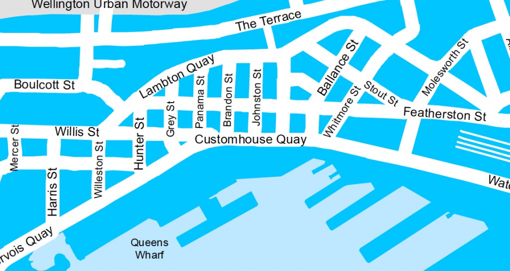
Well, probably, no. As can be seen by this tiny part of the map, Wellington has a real problem: at out most pinching of our pinchpoints, we have only 3 roads: the Waterfront, Featherston St, and the Golden Mile. And if you take one out (ie, say, Lambton Quay) for pedestrians only, and prioritise another (say, Featherstone St) for Public Transport (ie buses, trolley buses, light rail / whatever), then that leaves you with just one solitary route for cars: the Waterfront.
Of course, the traffic that currently roars along the waterfront isn’t meant to be there. It was meant to have been solved by the introduction of the Inner City Bypass – but we all know now what a tragic cock-up of traffic planning disaster that has turned out to be. Certainly the answer for me there is: don’t get traffic planners to solve the city’s pedestrian problems.
So: bring on the Space Syntax crew. The Fish has its tail all a-quiver: just can’t wait to see what they come up with.

page A10 of the DomPost today –
http://www.stuff.co.nz/dominion-post/4034692/Fancy-being-mayor-Jones-trawl-for-council-candidates
“Who didn’t get asked by Sir Robert Jones whether they would stand for Wellington City Council? By some accounts he trawled through a list of as many as 100 business, real estate, arts and media figures in an unsuccessful quest to find someone to stand either for mayor or on a council ticket backed by Vibrant Wellington, a group that has the support of a small number of central city property owners.”
Articles continues on, and notes that others approached include:
Ian Fraser, (former TVNZ head)
Keith Quinn, (former sportscaster)
Margaret Clark, (academic)
Mai Chen, (lawyer, partner of ex-PM)
Chris Gollins, (real estate)
Joseph Romanos, (newspapers)
John Ansell. (advertising)
The last one is really interesting – Ansell (an ad-man) is outed today as being the National party person behind the hugely racially devisive billboards from National last election ie “IWI vs KIWI”, and his attempts this year are even more racially oriented: “Visit your Beach before I give it to Iwi” – which is now an anti-National campaign.
Personally, I’m really glad that we don’t have such a racially motivated little shit as Ansell anywhere on the radar screens for Mayor. I think we can do without him…
It was fairly well known that Ansell designed the iwi/kiwi billboards at the time, so not really an ‘outing’…
Why is it that overseas consultants need to be appointed to assess the local traffic issues??? As reported, consultants from Australia have been engaged.
There are many examples of Australian cities that are failing in their current public transport infrastructure and future planning needs.The topograhy defining planning in Australian cities is totally different from those of Wellington.
Surely there are enough talented planners in Wellington with local knowledge able to formulate a workable solution.
Grumps – for an answer to that, please refer to comments from Guy on:
http://eyeofthefish.org/mayor-kerry-speaks/
It seems that no, there are not enough talented planners in Wellington. Nothing to do with Oz vs NZ either – apparently its all in the software….
Maximus -thank g-d for the software -without it we would be unable to resolve the issues in a practical way that many face on a daily basis.The council for many years, with no overall vision, has “enhanced” the movement of traffic so that to move from one side of the city to the other can now take over an hour. Applying the results of Syntax will only inflame the situation by re-aligning existing problems -eg. the current shifting of the bus routes back to Manners St.
Many years ago a bus interchange was proposed for Courtenay Place which was visionary at the time -never proceeded -try and introduce it now!!!!
The affluent population currently possess 2/3 cars per household on which they depend since the ‘feeder’ system of public transport into the city centre is dismal and unreliable.
Light rail is an expensive unnecessary option for Wellington -an advantage would be achieved by increasing the frequency and comfort of the suburban train system linked to buses for the next stage -smaller buses in off peak hours- that can be utilised in the narrower streets.
Grumps – while I agree with you that a bus interchange in Courtenay Place is a pretty unlikely prospect now, I’m not sure that I’d agree that the council has no overall vision for traffic. It’s the details of that vision that need work.
While it would be up to someone like Steve Spence or Soon Tec Kong at the WCC to confirm if they actually do have some overall masterplan – not sure if they read the Fish – the very simple answer is that large flows of traffic have only 2 routes to go – either down the waterfront, or in the Inner City Bypass(ICB). It seems pretty obvious to all except for NZTA that the ICB has been a dismal failure (if smooth-flowing traffic was an aim).
Traffic has not reduced along the waterfront. Traffic has become snarled up at teh Willis St / Victoria St / Brooklyn / Bypass intersections. In retrospect, it really would have been better to have the ICB go UNDER the Willis St at least, and possibly Victoria St as well, which would have separated North South flow from East West. Oh what a different city we would have now if that had happened.
Yes, traffic would flow better, which would encourage more cars to take the ICB rather than the Waterfront. NZTA will have studies that show this, but they will be under lock and key as they do not want to admit they cocked it up – or, were forced to cock it up by planning the situation we have now, of “low speed, friendly, neighbourhood” ground level connections. For pedestrians at those intersections, they would have actually been improved by grade separation.
Anyway, regardless of that sorry saga, I’m not actually sure if / how much Space Syntax has to do with traffic – as opposed to with pedestrians. Presumably it can. Maybe someone at Council could clarify the scope….?
I count 5 routes through the CBD not 3.
1. Waterfront
2. Featherstone St
3. Golden Mile
4. The Terrace
5. Urban Motorway
It seems to me that parts of the Golden Mile like North lambton Quay are so wide that if you removed private vehciles you could have 2 lanes for Public Transport and still increase the width of the pedestrian area by 2-3 lanes worth.
Interesting. Space Syntax is a company started by Bill Hillier, an academic who investigated, well, space, principally pedestrian space. I’ve read a few of his journal articles – essentially his methodology confirms pedestrian routes in a given area, and lays them out on a map for all to see (just skip over the stats – there is quite a bit in his articles). Quite good stuff.
He’ll do good work in Wellington – and I for one would be interested in the report that is produced. He’s done a number of cities around the world so it’s good that Wellington is the first NZ city.
The trick here is for smart Council people here to *learn* from Space Syntax – even if they just picked up a good understanding of the basics – this will improve their understanding of spatial relations between things in the city. That knowledge transfer alone makes the fee worthwhile.
The trick for Space Syntax is to marry their technical knowledge to the field knowledge held by Council staff – which I’m sure as professionals they will do – but a good melding together of these two knowledge areas will make for a cracker of a report. Maximus – can you post a link on here when it gets released?
The tricks that you suggest, Christopher, are simply not enough. It is ok to learn from and marry the expertise etc etc, but what is needed is a commitment to the implementation of the findings. As we have found with the last high-profile urban consultant (Gehl), watered-down implementation defeats the whole (expensive) exercise, with outcomes of questionable merit.
[…] Hattip – Eye of the Fish Categories: Uncategorized Comments (0) Trackbacks (0) Leave a comment Trackback […]
QH – Well, not really 5 if you are just looking at the flat area, where people are walking and shopping, and going to work. But yes, 5 if you are counting cars – although, cars going from one end of town to another on the motorway are not that common.
And yes, you’re right that parts of Lambton Quay are very wide – but of course, the crunch comes at the pinch points: which are the ANZ, (cnr Lambton / Hunter?) and the Old Bank especially (Willis / Lambton). Effectively then, the maximum width of any road is controlled by the thinnest width. ie, the Maximus is the Minimus… and vice versa.
You can guarantee that a hundred traffic planners have sat and thought at one time or another “Damn and blast that Old BNZ Bank – its in the way – our traffic woes would be so much easier if i could just knock that building down.”
But we can’t, or won’t, and definitely shouldn’t – so, instead, we have a system that is on the edge of grinding to a halt.
@m-d: yes, agree, implementation is the hard bit and often at the whim of which side of the bed the council officer got out of in the morning and too often subject to straight middle aged middle class white men of a certain world view who think they know better and interferring.
I note Auckland City Council’s CEO implemented a ‘just do it’ policy which has been remarkable – a number of projects were just got on and done with. They may have attracted criticism or mis-informed commentary but the majority were just done. Mostly small stuff really – up to $100m projects. The next step is to ‘just do it’ for the large stuff – but Council is still learning about a) getting the small parts of the big stuff right and then getting it done.
However, don’t underestimate the power of learning, which is hopefully will happen with Wellington CC officers.
Maximus- Im all for pedestrianisation of the Golden Mile, but I dont see why it has to all be done at once. It would be easiest to pedestrianise the wider sections of Lambton Quay and Courtney place. That would keep the golden mile as the PT route and be a first step towards full pedestrianisation.
Well hold on there QH – just how would that work? You can’t have traffic appearing in some parts of the Golden Mile and then disappearing at other parts, without creating a great big Snafu at each intersection.
Or maybe you can. Sadly, only a traffic engineer could work that out.
But I think that it is precisely because of 2 small corners and ensuing traffic, that the whole of Manners Mall is being dug up and replanned, just to get around the existing areas where the traffic leaves the main route.
Vehicle traffic already has the waterfront to itself – you don’t see many people walking along the roads there (obviously, on sunny days, they go via the waterfront promenade), but I think that if you banned buses etc from the Golden Mile, then it is pretty obvious that any buses would have to use Featherston St – in BOTH directions. And that’s the point that Bob and Kerry are arguing over.
What would Bob care about buses or taxis, courier vans and trucks. Once he’s finished strolling about admiring his buildings he’ll no doubt have a car parked under one of them.
No doubt. He’s got a Jaguar, or did have, when he last made the headlines (giving a bollocking to the policeman who pulled him over and ticketed him, and i think Bob subsequently won in court).
But he’s also passionate about walking the streets, sitting outside with his pipe, watching the pretty girls go by. I think his argument is that he would rather do that without buses going by emitting diesel fumes. So, an electric powered Tram would be right up his alley, so to speak.
Re: the pinchpoint of the Old Bank etc.
I’ve got an old book somewhere with a picture of a bendy-bus going around the Dawsons Jeweller’s corner.
Maximus -there are probably numerous reports filed on shelves or locked away which would expose the shambles of traffic flow which now exists in Wellington.
An inexpensive solution to some of them would be to eliminate the traffic lights that cause a stop/start reaction that eventually backs up by constructing pedestrian tunnels under the road -particularly along Jervois Quay, around parts of the Basin Reserve, Newtown, Karori and many other areas -this would eventually lead to better traffic flow that works its way into the city.
If as you say the council have an overall vision but fail to implement the changes then at least start with the small things and eventually work up to the bigger plans.
Transmission Gulley has been 30 yrs in the discussion stage -so was the motorway extension past the Carillion –
Seamonkey – send it in and we’ll post it up – I never knew we ever had bendy buses in Wellington. How odd. If Poneke was still around, he’d tell us.
Grumps – No no no no no no…. that is prioritising the car over the pedestrian, which is exactly the way that an old-fashioned roading engineer would think. What is more important to a city – people? or people’s cars? The trafficist would say that the smooth flow of traffic is most important. But the humanist would say that people are the lifeblood – no one wants to live in a city that lets cars flow smoothly but forces people underground.
So, what is happening in the city at the present is completely the opposite – the deliberate slowing of traffic along the waterfront, so that people get frustrated, and chose another route – and the only route available to them really to get out of the city fast is the ICB. Which doesn’t work as a smooth flowing thing, as it is doing the kind, caring, neighbourhood-friendly, pedestrian crossing thing.
One of the key things about the Waterfront route that the Council promised / intended, and that arguably Mayor Kerry has not kept her promise on (although, to be fair, its probably not something within her control), is the reduction of traffic along the Waterfront. Step one was to introduce the new pedestrian crossings, which have made it more possible to get people to walk from City to Sea (people hate to walk under roads in tunnels, as it is inconvenient and threatening, and apart from the City to Sea bridge, people just can’t be arsed climbing up to a bridge to get over the road either).
Step two is the deliberate reduction of number of lanes, and the greening of the Quays, to make it a more pleasant place to be. We’ve had a half-hearted attempt at that – the Council has squeezed in a single row of trees down the centre of Jervois Quay / Customhouse Quay, which is nice, but there was meant to be a concurrent reduction in lanes from 3-4 each way down to a mere 1-2 each way, and another row of trees either side, taking up at least a lane of traffic each side. A ‘boulevard’ was the description given in the paper at the time. The waterfront would therefore be a nicer place for people to walk, and cars would be a bit more squeezed out, and would in theory go off to use the Bypass.
Maximus -a modern city needs to compromise between the people -(pedestrians)-and their means of transport out into the suburbs where they live. Forcing motorists to restrict usage of their cars by creating barriers in the city centres is not a solution. Cars and trucks -(for deliveries) -are here for the next 100 yrs plus -petrol slowly being replaced with electric – so any city needs to adapt.
The option of intermittent pedestrian tunnels under the waterfront road is a considerably cheaper than placing the whole road underground as has been suggested before.
By eliminating surface pedestrian crossings pedestrians would have limited options -the tunnels can be made “people friendly”
From the old BNZ building on the corner of Willis St down to maybe Stout St could be a totally pedestrian precinct -traffic INCLUDING buses could use Featherston St and Customhouse Quay –
More thought into one way streets – eg. Dixon St traffic and BUSES should have been allowed to continue on to Willis St and then turned right by making Willis St one way north.
The original plan of one way traffic around the Basin Reserve was brilliant at the time -it has now been defeated by sets of traffic lights that hinder flow and could be overcome by a few tunnels for the pedestrians.
Pedestrian tunnels in parts of Wallace St. mostly for the students would assist in creating better traffic flows that lead back into the city.
Instead of a co-ordinated plan being adhered to the council bends to many pressure groups which eventually ends up frustrating everyone.
Grumps – I’m 100% with Maximus on this – people before cars. It’s a very big ask to make underground pedestrian routes safe, and they certainly aren’t attractive. Re the Basin, I’m not sure what the stats are now but I remember that pre traffic lights the crash stats were ugly because people were having to change lanes all over the place, with traffic flowing at some speed – result a host of crashes.
The key actions need to be around reducing the number of trips taken by car that could be taken by another mode. Getting urban form right so a greater proportion of people can walk (last census 73% of the people living in the CBD/Adelaide Rd walked to work) is critical as well as improving the circumstances for PT and active modes. I’ll put together something on where I see that collection all heading over the next 5 years or so.
Warmest regards
Cr Andy Foster
Urban Development Leader
Wellington City Councillor
Andy foster – The statistics are great for those living near or in the city centre, however the majority of citizens, who work or require to travel for shopping or business, live in the outer suburbs.
Your plan of reducing trips is ideallogical until such time as everything becomes decentralised -eg the Johnsonville shopping mall extension will reduce the flow of shoppers cars which in turn will lead to the demise of Lambton Quay who will come to rely on the office workers only.
The original design around the Basin reserve allowed for traffic to merge as well as change lanes -most of the minor accidents occured because motorists were not educated in how to negotiate the movements.
Sticking up traffic lights all over Wellington is an ‘easy out’ to the alternative of trying something new.
A 5yr plan is very short term -eg. the pilot hole for the 2nd tunnel through Mt Victoria was drilled over 30 yrs ago and still remains blocked -another part of a plan never put into practice.
Grumps – going to have to agree to disagree with you on tunnels – aside from walking down into a subway to catch a train – I really do not ever want to have to cross a road via an underground tunnel, and I suspect that most Wellingtonians would agree with me on that. I’m sure someone somewhere in the world will have done some research on that – certainly in my time in England I never found that people would be keen to use the underground subways to cross roads – they’re generally dark, badly lit, graffitied, noisy, threatening, smelling of urine, and to be avoided at all costs. Women especially would avoid them 100%.
At least at ground level people will be highly visible (so a degree of security), and, if not necessarily warm and dry, then at least away from the noise, smell, and nefarious deeds of the underworld.
Your comment “Sticking up traffic lights all over Wellington is an ‘easy out’ to the alternative of trying something new.” has me puzzled. If that is the easy way out, what is your plan for the hard way? The tunnels? Or something else?
Maximus, I recall KP stating that the traffic along the waterfront would be reduced to 2 lanes EW from 3 when the terrace tunnel was duplicated. Of course, I haven’t listened to everything KP has said, listening to any mayor too much would drive anyone mad, so she may have made earlier contrary statements (also, if she’d made a statement basing the lane reduction on completing the ICB, that would’ve been very silly indeed – all the ICB really did was remove SH1 from Ghuznee St, and as a Cuba St pedestrian that alone is to be congratulated). But anyway, how about the waterfront/terraces/Adelaide for light rail along the centreline with stations at Railway, Post Office Square, Waitangi Park, South Courtney, Basin (each side) and Hospital. Would be speedy along the waterfront and the terraces, provide diveristy of public transport options, connect to buses at key points, and be out of the way of the buses generally. Lambton/Manners can then be left to the buses. Also they need to fix the north-bound car issue through the CBD to give a partner for Featherston. Suggest removing all south-bound cars from Lambton to start with and close off some of the side streets (would make crossing between classic Kirks and the homewares bit nicer).
“Grumps” and “Andy Foster” – and “Mayor Kerry” too if you’re watching – Regarding the Basin Reserve, have you seen the solution proposed by the Arch Centre on this? You might be interested….
http://architecture.org.nz/2010/07/11/basin-reserve-solution/
Less traffic lights, fewer intersections, better traffic flow, and way better pedestrian environment. We think its a winner.
Guy, a quick aside.
When I tried to access the Arch Centre link, my anti-virus shot up some warnings, along with a Java Virtual Machine Launcher warning about being “Unable to access jarfile \\ramgonet.com\smb\old.avi”.
McAfee picked up 3 warnings about trojans, detected as Expolit-CVE2008-5353…..if that makes any sense?
Maximus
Furious urban-design/pedestrianisation debate aside, you appear somewhat downcast that you don’t get the invites to all the best press conferences. We’re more than happy to put the Fish on our media list so you get all our juicy media invites – but that may also mean you have to deal with 1001 releases about pipes and rubbish bags and sewage and all the other joyful issues the Council has to deal with apart from urban-design issues. Just say the word if you want us to chuck your email on the list.
cheers
Richard MacLean – WCC Comms
Maximus & all -I am sure some tunnels could be made user friendly. An alternative is the occasional bridge over some thoroughfares. What ever something new needs to be done because the current system does not work!!!
Re the traffic lights -there are numerous points around the city and suburbs where traffic lights have been installed for the convenience of the pedestrians who seem unable to walk 50-100metres one way or the other to cross the road.Count the number of stopping points along Cable St for example. Are all of them really necessary??Promoting good health by walking a few metres never hurt anyone.
The proposal of a North/South tunnel under the Basin was raised many years ago. Another scheme that had potential to alleviate traffic grid lock that now exists.
There has been a mindset in Wellington to retain the trolley buses and overhead wiring – a follow on from the trams that used to exist. The trolley’s are a very expensive item to maintain these days. The overhead system causes restrictions in where they can be utilised. Question -are the trolleys environmentally acceptable when considering the amount of electricity consumed in their day to day running??? Anyone calculated the extra environmental damage created by having numerous vehicles stuck behind slow moving trolleys??
Maybe time to dismantle the trolley system and replace them with smaller electric buses. This would allow more flexibility and efficiency in redesigning public transport.
I just don’t see why so much thought goes in to looking after the Quays, in particularly reducing traffic. Why?
If you could stop traffic passing through there tomorrow, would it flood with people? No it would not. The city side is bordered by office-block fronts and service stations, the waterfront side by heritage buildings with no public access and the TSB Arena. People won’t walk North-South because there is nothing there for them, they will walk East-West….and keep on walking to get to the water or the golden mile (depending in which direction they are heading).
Getting rid of traffic will create nothing more than a 2km-wide pedestrian crossing. So why bother reducing traffic at all. Have overbridges at strategic points along Customhouse Quay which provide direct, uninterrupted access between the waterfront and the golden mile, no matter what the traffic is like below them.
Traffic can continue along the Quays so that the Golden mile – which has the cafes, restaurants, shops, green spaces etc that attracts people – can be fully pedestrianised.
KLK – well, the thinking goes that if there was less traffic along the Waterfront, then people would want to be there, closer to the sea, and then these buildings would blossom with life: cafes, restaurants, shops, etc.
I agree its not happening at the moment – but that’s cos it is like a motorway, and no-one wants to sit in a cafe looking onto a motorway – but lots of people want to be in a cafe by the sea.
Think of the expression : Boulevard
Except it would be a boulevard that’s nowhere near the sea.
Sit on a seat on Customhouse Quay and look out towards the harbour. What do you see? Certainly not water – Meridian and the heritage sheds, Queens Wharf, and TSB Arena. The area is already disconnected from the waterfront by buildings. Why would people stop and sit on the non-harbour side when they can walk an extra 50m and have glorious views? (weather issues aside…)
People flocking to be nearer to the sea, as you correctly predict, would walk straight through it – non-stop – until they got to the waterfront and the cafes and restaurants already lining it.
I’d work on the overbridge idea to get people back and forth between CBD and waterfront, as and when they like, not having to wait for the lights to change. Hell – even traffic would run more smoothly through there without lights.
KLK – you are, of course, exactly right – and that is exactly the point. People don’t flock to the waterfront (except for on really gorgeous fine days like today was) partly because they are stopped by the wall of traffic that splurges along the waterfront. Break down that wall (ie remove traffic, or slow it down with pedestrian crossings) and people start to filter across the road and up to the waterfront. There has been a massive increase even just in the last couple of years, with the partial planting of the Boulevard, and the throwing open of the Wharf gates near the Kumutoto area, and the new pedestrian crossings – and it all acts to get people across the road and onto the seafront.
So saying though, your idea of bridges is a great one. The City were talking about adding another bridge a few years ago, but no action on the horizon yet.
Grumps – no chance yet for electric buses. My sources indicate that massive battery loads make this all a bit unfeasible at present. Yes, trolley bus wired look unsightly – and are poorly maintained – but I understand it is still more energy efficient than batteries.
New battery technology within the next 10 years (according to Tesla Motors) will improve things – but we’re not talking the old lead-acid batteries here. The new batteries being developed all seem to use rare and precious metals, and the process for getting those metals causes massive mining problems in the country it is mined from.
Maximus – I’m not sure people stop going to the waterfront when they want to because there are cars running along the Quays. I’d guess they go regardless. They’d just like it to be a bit easier to get there. The massive increase in activity is a product of waterfront development, even with a semi-motorway one block back.
Reducing cars on the Quays, to me, seems pointless. Ideas that they might evolve into Boulevards implies they will be made shared spaces (at worst) and as is pointed out, the limited options for traffic were Lambton/Featherston pedestrianised mean this won’t ever be the case. So even reducing it to two lanes each way, with a 30km speed limit even – still results in a “wall”. And that’s before taking into account excess traffic from Lambton/Featherston sts.
Convert it into a different type of “shared space (ground and air) – cars (incl the excess from the pedestrianised street) run freely on the ground with few traffic lights, and waterfront/CBD goers walk freely overhead day and night.
Everyone wins.
I have heard any number of times that the process of trenching the Quays is unthinkable because of cost and the multiple unknowns about infrastructure beneath, but what are the chances of excavating a couple of reverse bridges- vehicle underpasses which take the roadway down a few metres at key intersections and allow pedestrian traverses at only slightly elevated levels?
If ultimately there is a choice between making the Quays a more effective vehicle conduit and carving more chunks out of the fabric of the CBD in the hope it might re-route the crosstown flow I’d put my energy (and my traffic engineers) there.
Starkive – glad you like our “Commnets” button – one day soon we may even get it spelling Comments….
We’d need a traffic engineer to really reply to that – or a civil / structural engineer – but I’d just note 2 things:
The ground level there is only a couple of metres above mean sea level, which means that the High water level is only 1 metre below the road. To get a highway to go down there, would require a hole about 5-6m down (roadway needs to be min 4.6m high) and so therefore it is digging a hole in the ground that is then about 4m underwater…. the hydrostatic pressure then acts on the underside of the ‘underpass’, and forces it up out of the road…. basically speaking, its not impossible, but it is messy. And expensive. And creates a barrier some X hundred metres long to allow for the ramp down, and the ramp back up again.
So, basically, in a word: NO.
Sorry
Part Pedestrianisation
What I meant was keep 2 lanes along the Golden Mile for PT and a future light rail route, then stop private vehicles.Then the wider bits of the Golden Mile can be instantly turned into wide pedestrian malls (with 2 PT lanes on the side). North Lmabton Quay is easy to see this happening the exisitng median could deliniate the peds and the Buses.
Bendy Bus
Old bank corner is tight, but light rail woudl have no problem. modern trams actually take up less road width thn buses and can navigate very tight corners due to the tracks.