Following on from the last post we made, an April Fool’s gag that seems to have genuinely fooled some of our less discriminating readers, it’s with no great surprise that we hear of the demise / further delay of “Memorial Park”. It was the other potential target for our 1 April prank – where we were set to announce that the Park was to go ahead – but even we didn’t think that anyone was likely to be seriously taken in by that story. As the weeds grow thick and fast on the former building verge, and the hurricane wire fencing sits slowly gathering detritus, it has looked increasingly unlikely that it would ever get a go-ahead.
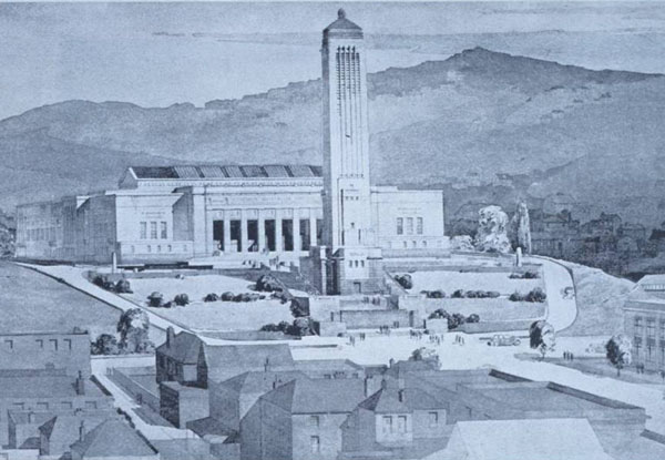
As a pet project of the former Labour government’s Minister for Culture and Heritage, it was always going to get a hard road (no pun intended) from the incoming National team. As a project to honour and respect the war dead from NZ’s and other countries, it was fatally flawed, and as a piece of inner-city roading repair, it was a dog of an idea from the very start. While there are some parts of it that have merit, overall it was a disaster, and we here at Eye of the Fish believe that Wellington, and our national War Heroes, deserve better.
Over a year or two ago, the Ministry for Culture held a competition to look at what the park could be – and we think that now that the project has been ‘delayed’ yet again “till past the May funding date”, the Ministry should have the guts to at least publish the results of the former competition and say: “Look, here is what we could have had.” As someone interested in Architecture and Urban Design, I’m absolutely dying to find out what schemes were proposed, and my tiny flippers are flapping with excitement at the thought of what juicy ideas the assorted architects might have come up with. I’m especially keen to find out what the end result was – what final scheme or schemes were on the cards, before the final shelving. Were there any good ideas for Memorials, or were they all just glorified roading schemes? Come on Mini-Cult, you owe us at least this much!
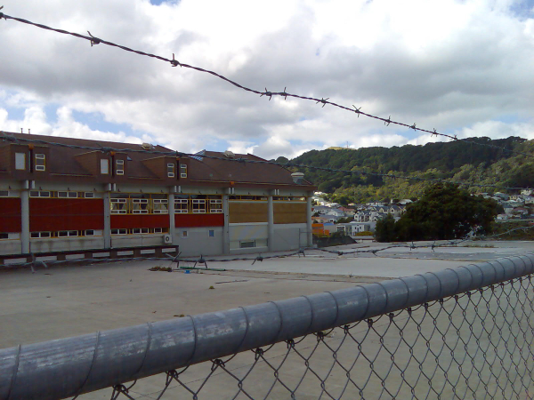
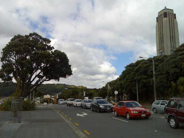
The route of the current road runs along Buckle St, which sails past the old Police station and the base of the existing War Memorial. Behind the Memorial and the Carillon sits the former Museum, built on the site of the former Mount Cook gaol, and now as we all know, the home of Wellington’s bleeding stump of Massey University. The Museum’s conversion into Massey was never a great success – I remember the review in the local Architecture magazine gave it an absolute raspberry, and deservedly so, but the access up the hill to Massey was as deserving of a black mark as was the appallingly bland conversion inside. The current road past just brutally cuts off the base of the access to the Museum as well as treating the National War Memorial with as much gravitas as if it was an electrical substation on the side of a motorway.
Clark’s push for the road to be re-routed was a good thing – Mini-Cult’s gradual buying up of low quality sheds and caryards along the Memorial Park route allowed the potential for the road to be pulled away from the base of the hill, and a more fitting stretch of verge to be planned. The land sits there still, waiting for action, enclosed in rented steel wire mesh fences, as if it were an historic jewel about to be stolen. We have no idea what they think people may be about to steal. On offer on the enclosed sites are such gems of detritus such as used asphalt (2 hectares), redundant concrete slabs (1 hectare), and weeds in a gravel compote (3 hectares). Come on Mini-Cult people, get your act together. Yes, we know that one day the road will be moved, when the issues of killing off local school children with exhaust emissions has been solved. Yes, we know that in theory there may be untold treasures such as bits of broken bottles and ex-convict bricks lying beneath the tarmac, but there is a very simple and low cost solution that should be taken immediately to return this land to the People: dig up the asphalt, take down the fences, and sow grass along the whole shebang. No landscaping, no fancy anything, no re-routing the road at present, just grass and no fences.
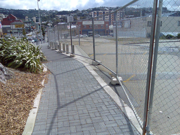
We’ll cover off in another post What Should Be Done with the land at a later stage. But for now it should just be taken up (asphalt) and taken down (fence). It wouldn’t take long. It’s the sort of project that Boy Scout troops and Rotary clubs do all the time, for weekend working bees, and really: it wouldn’t take long nor cost much. Just Do It.


Has anyone seen any plans of the proposed basin flyover? All I’ve seen is that terrible perspective. My question for asking is that there is some interaction between where the flyover would intercept the bypass and where the proposed memorial park is. My guess is we’ll get a flyover before we get a park – the logic being the construction works for a flyover will only cause additional demolition and construction work, so it will be postponed.
Not that I think this is what SHOULD happen. Just my guess as to what will.
This issue goes a bit beyond Wellington as well though. In the 2007 Federal budget, the Howard government in Australia allocated A$5 million for an Australian memorial on the park in return for the (very cool) NZ memorial at the beginning of ANZAC Ave in Canberra and I know the British Government were looking at also doing something in return for the London memorial.
So its not big money in comparison to how big this project could get, but there is an international angle to this and hey you could even argue that it would be stimulative (creating road building/landscaping jobs) – so let’s get on with it.
This should have been a Road of National Significance or whatever they call them, you know, excuses to plow money into motorways. That way fund the cut+cover tunnel and get it over with. Long term solution. Finito.
jayseatee, whatever happens here definitely has to interact with the Basin Reserve. I’ve been having issues trying to get straight answers about how, and what will be the future costs if a four-lane tunnel under Memorial Park were ever wanted in the future. The only straight answer I recieved was “there is no strategy”, literally. So the Basin Reserve work could well paint us into a corner, or could well end up costing us more in the long run. But that is because it is too limited in scope.
My understanding is that the Mayor and Council have been briefed on the Basin Reserve by Transit (or LTSA) roading engineers, who of course have said there is only one way to solve the Basin Reserve choke point, and that is with an overbridge on the north side of the Basin. Actually, there are at least three variants on that, but they all involve an overbridge.
While I totally disagree with their conclusion, and indeed think that Roading Engineers are the wrong people to design the traffic solution (given the almighty cock-up that is the Inner City Bypass), the advantage that an overpass would have would be to integrate well with Memorial Park, and especially with a lowered roadway to Memorial Park.
But that will take some years to work out, and in the meantime, the land sits barren and fenced off. It should just be grassed over, until the boffins have their road designs confirmed and their contractors ready to roar.
maximus- instead of just some grass, how about a community garden?
but now that I think about what’s been on the site, I probably wouldn’t want to eat anything grown from it.
My rationale is: that something will get done here eventually. Just prob not for a couple of years yet. So don’t hold your breath. Hence: at least grass is better than fence.
Look at the situation of the Grassy Knoll (in Wellington, not near the Dallas Book Depository). It was just a temporary left-over pile of dirt, and then it got grassed over, and was happily utilised for a few years. Or it could have remained as pile of rubble and weeds for several years.
I know what i’d prefer.
“…who of course have said there is only one way to solve the Basin Reserve choke point, and that is with an overbridge on the north side of the Basin…”
Yep I imagine that is what has been said. But it isn’t actually written anywhere that it *must* be an overpass, this is only a relic from the old Meritec report in 2000-2001. The N2A reports suggest that the appropriate solution needs to be discovered through a new scheme assessment, and only that grade separation of north-south/east-west traffic is prescribed. The discussion of options in the N2A reports were again simply taken from the old car dominated Meritec report. So if done right, true to the new wording, and properly considering the urban environment as part of the new engineering study, then it could just as likely end up with another solution (e.g. north-south tunnel). But this is entirely dependant on what goes into the tender for the new engineering study, and I fear everyone has been so distracted fighting the idea of a flyover they’ve forgotten to look at this and pursuade the authors of the tender (NZTA) to word the tender correctly. Thus, we end up with a flyover.
Grassy Knolls are good, definitely better than wasted space. I’ve seen the big concrete pad being used by some skateboarders on ocassion but otherwise it is awfully wasteed. What about giving the land to poor people who can’t afford housing due to the economic clusterf*ck we’re experiencing. Erect a shanty town. Would be a great monument to capitalism. :)
Your precious jewels inside the wire fence are in fact very valuable heritage grounds full of likely significant archaeological artifacts and should not be dismissed so glibly
Maximus – I think that the Grassy Knoll was a “pre-load” – the idea is that, instead of mechanical compaction of subsoils with all of their entrained problems (remember Te Papa) the owner can truck in a load of dirt to slowly squash the compressible layers.
If the Knoll weighs about as much as the future building does then it does the job of prepping the site for that building.
Wasn’t there meant to be some sort of whare going in there next to the rower’s lagoon?
It’s a good cheap solution if your building isn’t too big for the site and one has time available – I think the Knoll was there at least a couple of years.
I hear that the land on the seaward side of the motorway NE of the Interislander ferry terminal parking area(aka “the pimple”)was meant to be a pre-load but perhaps a viewer can enlighten us?
can we just demolish the basin please?
I recently received the result of an OIA/LGOIMA request to NZTA, GWRC and WCC back, and it confirms what everyone suspects – there is no detailed design for the Basin Reserve “grade separation”, aka flyover. The stuff they put in the public consultation documents – you know, the pictures with the birds and the trees the flowers and all – are the sum total of everything NZTA is prepared to admit to. Oh, and just for kicks, all parties admitted that there have been no geotechnical investigations, despite the area rising 1.8m in the 1855 earthquake, so any costings have to be taken with a truck-load of salt.
All of this astounds me. It appears that our local body officials are prepared to vote for a flyover that will dramatically change the context of the Basin Reserve with no clear idea what it’s going to look like. All the documents are pretty clear that it will be a flyover and not a tunnel, but no-one – least of all the people who voted for it – have any idea how bad the impact on the Basin will be – well, aside from NZTA’s own consultants. Opus said:
“The elevated structure for the grade separation of the Basin Reserve will be visually prominent and will affect the perception, symbolic character and context of the Basin Reserve and will impact on the overall character of the wider surroundings. The grade separation may also adversely affect the experience of those using the Basin Reserve.”
A tunnel would be a far better option, assuming of course that the falling traffic volumes even require any form of grade separation if we run them forward a few decades. But to try and shove through a flyover when even the most cursory attempts at traffic management (bus lanes, bus priority at the lights, etc etc) haven’t even been explored simply illustrates the degree of blinkered traffic planning that is occurring.
Is there any other kind of Traffic Planning than the blinkered kind? I don’t think that traffic engineers are ever taught how to think laterally or creatively
Good work on the OIA work too. Although somehow I think that someone is not telling you the truth. Surely, surely, someone at LTSA must have done some more drawings by now
Why is the Basin still used for cricket these days? All the matches I’ve been to have been at the Cake Tin. I don’t see why a city the size of Wellington should warrant two international cricket venues.
If we didn’t need to use the Basin as the center of a giant roundabout, then we could build an enormous 4-level stack junction in the middle of it. Or find some other use.
Oh, and as for the asphalt and concrete alongside the bypass… I’d assumed it was for lanes heading in the opposite direction rather than a war memorial. But if you dropped both directions in to cut and mostly-covered tunnels, you could build a nice park over it. And buildings. And roads could cross it without actually being joined to the bypass with a junction… Tory Street would be a good candidate to cross a below-grade bypass on a bridge.
Maximus – The OIA stuff is a work in progress, for sure. NZTA replied to my request with “we have nothing other than the public documents, and besides, the rest is commercially sensitive since we paid Opus to do it.” The Ombudsman didn’t believe them either and is currently investigating.
Given that Opus have been paid to do all the heavy lifting on the Basin Reserve flyover – they’ve apparently done the design, the impact assessment and the traffic modeling – it does rather beg the question why we bother having a “NZ Transport Agency” at all. I feel some redundancies and a few million dollars in savings coming on ….
davidp – you are so wrong about the Basin not being required for cricket. Where have you been? The last day of the test match is tomorrow by the way. But your idea of Buckle Street aka Karo Drive being ‘undergrounded’ is on the money.
kent – I agree – a tunnel would be a far better answer. The best solution I have heard is to drill a new east to west tunnel from Hataitai aka Whataitai to Adelaide Road. It could start near the road that leads to the tennis / netball / softball / velodrome. Then run under the hill deep below the Government House lawn and exit at Drummond Street and onto Adelaide Road. This would firstly solve the tunnel bottle neck, and secondly require east to west traffic to only use the the SW quadrant of the Basin roundabout. Currently this traffic has to use the SE quadrant as well. Grap a map and draw the route yourself – it seems very simple. The existing tunnel could then be used for only west to east traffic and a cycleway. It avoids the need for the overpass and the massive negative impact this would have on the Basin and its surroundings.
I wonder if anyone from the Council could clarify the timeline as regards to the traffic planning around the Basin and the Memorial Park?
Hmm… it will be a steep drop from a flyover over Cambridge Terrace to a tunnel under the lovely new park. Lots of out of control commuters plunging into the bowels, so to speak. Especially fun with said tunnel ending at the Taranaki Street traffic lights of death and piles of traffic all queued up in the tunnel. Ouchies from behind. Just another example of teeerrrrrrrrrrrrrrible road design ala Victoria Street. Might have got the park built by now if the Council and the Minister could agree on the pingers but every mayor loves a memorial…
So, “every mayor loves a memorial”? I reckon that Kerry P has done a good job, held it all together, albiet nothing too outstanding. But surely even Kerry would be aiming higher as a memorial than a traffic-choked overbridge? Would it be called the Prendergast Bypass? Or the KerryAerial? I’m pretty sure it won’t be the Iona Pannet overpass….
What you oh-so-clever and cynical lot seem to fail to realize is that the levels for the proposed overpass would tie in perfectly from the entry to the current tunnel, flying pretty much straight across the end part of the basin reserve, about 20m up so the noise and the cars won’t disturb you, and then land neatly on the edge of Tory St . What’s wrong with that? The bypass won’t be going to spoil anything on the Reserve itself as the concrete bridge pylons won’t actually be put through the grass on the Basin, just a few round the edge.
Seems that not all cricket lovers see the proposal as a desecration of the beloved Basin. See Muppet #5…
http://www.stuff.co.nz/sport/blogs/sideline-slogger/2321241/10-muppets-from-the-Test
Rondo, I don’t think the mayor would be keen to have a flyover in her honour but an overly expensive park I suspect would be just about right. Alan, yes the levels are brilliant here for Mt Vic Tunnel-to-Buckle but what about Mt-Vic-Tunnel-to-Inner-City-Bypass-Stage-3? The current Bypass is Stage 2, Stage 1 was the One Way Pairs instituted in 1991 or so (can’t remember the exact date, I was still in nappies :-P ). Stage 3 is still a possibility and it involves grade separation of a type all Wellington drivers (and most pedestrians heading north-south) would like to see, with the damn thing dropped in a trench (and hopefully partly covered). This would place SH1 Buckle Street UNDER the park, which is a drop from a flyover over Cambridge Tce. Helpfully the contours rise from the Basin to Mt Cook – anyone here a surveyor with some spare time and wanting to confirm?
Starkive – yes, Muppet #5 says: “The protester outside the ground whingeing about a new road that may pop up outside the Basin Reserve. Given the fact that the ground is in the middle of a roundabout, the presence of cars and trucks on a new road nearby doesn’t sound like a death knell for the Basin to me. It sounds more like professional protesters who hate roads having another whinge, and trying to deploy a bit of scaremongering among cricket fans to help with their cause.”
I’m not really a cricket fan, and so if they don’t mind a flyover cutting across the paddock then perhaps we should just let them have one.
As it happens I am a cricket tragic and – to the extent that being an Auckland supporter will allow – a Basin lover. I have often slumped on the grassy bank and plotted how much better the ground could be while still remaining the Basin. Most of those plots involve the northern end of the ground where a new structure between the Vance stand and the embankment could house decent food and toilet facilities, provide for a somewhat larger crowd and break up the northerly. It does seem to me that the right design (!) could exploit opportunities provided by a flyover structure.
The worst part of those thoughts is that they appear to bring me into agreement with Cr Morrison – not a place I would often go.