
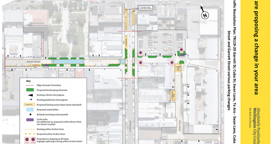
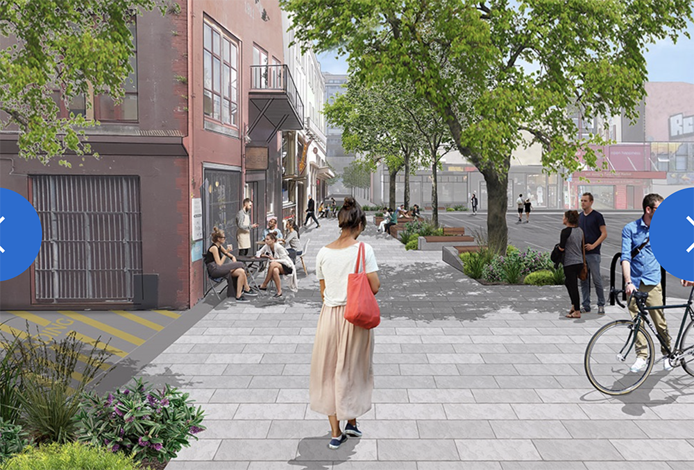
A missive has arrived from Wellington City Council, outlining that they have a plan for some changes around Garrett St (just off Cuba St) and Swan Lane (opposite Garrett St). In the interests of speediness, as they have a very short period of consultation, I’m going to post it here. There is actually screeds of paperwork, with parking places spelt out in GPS coordinates (Ha! try to prove that wrong – or right!). There is only one drawing however: this one right here. I’ve rotated it for you so that it makes more sense: north, as always, is up the page…
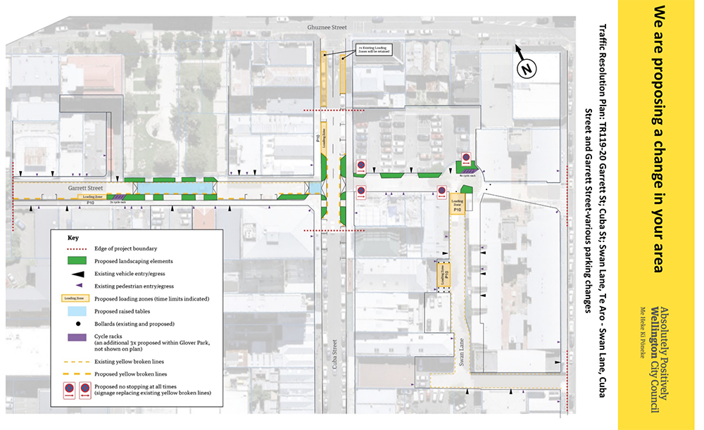
It seems that this people and places exercise has started with some mighty aims but has ended up with lesser ideals. It is now a traffic exercise, curiously muted of any great amount of useful pedestrian quality. The Council claim that: “The proposed changes will improve pedestrian visibility and safety, increase pedestrian accessibility and provide additional public amenity space and will not impact the primary functioning of the streets and Swan Lane with access to buildings, businesses and servicing requirements.”
I certainly have some issues with this proposal – but will keep them to myself at present. What do you think? Care to share your thoughts here? Is this an improvement? Or a step backwards? Or just a waste of time achieving nothing much?
Submissions on this plan are due with the WCC by 22nd December – you’re not busy doing anything else round then, are you? Christmas shopping perhaps? Relaxing on holiday at the beach already? Make a quick submission before you leave town – cos heaven only knows this will get lost after Christmas. Please provide feedback on the proposed changes online, by email to trfeedback@wcc.govt.nz , or in writing and send to Transport and Infrastructure, PO Box 2199 Wellington.
Post-Script
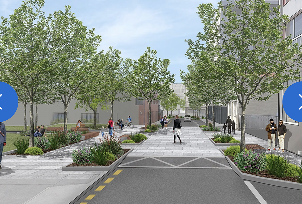
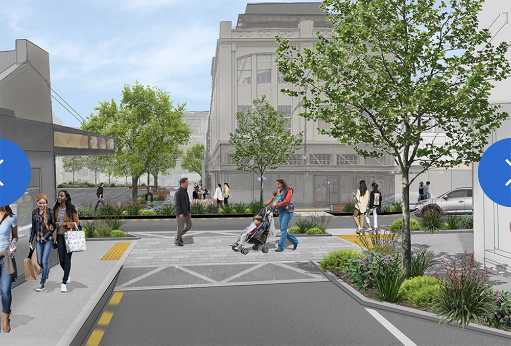
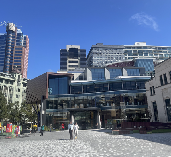
Above is an image from the Council document many months ago, which I think is taken from Garrett St, near the Green Party headquarters (OK – the Rogue and Vagabond – know it now?). The image below is also from Garrett St, looking across Cuba St at the entry to Swan Lane, which is closed off in the pic by some vigorous gardening. That’s all well and good – but it is not quite what is shown on the latest Traffic Plan above – where cars are clearly still allowed to drive down Swan Lane. No, No, No, and also No. That is not what we (the people) wanted. Cars driving down Swan Lane means that it continues as it already is: an area for vehicles, not an area for people.


The carpark bordering Swan Lane is crying out to be acquired (purchased? swapped for the Oaks?) by the Council and turned into the piazza that the Cuba Quarter badly needs. Sheltered and not so big as to become bleak on those rare inclement days, but big enough to host carnivalesque events. Imagine the north and east edges suddenly woken up by the removal of the phalanx of parked cars and pierced with small enterprises. Imagine a summer of people lounging like it’s Barcelona without the lock-down.
I agree with you there sir – it is an obvious and well-overdue place for a public park. But how to force it to become so, if the current owner does not want to sell? (which I believe is the case).
Forcing them to do something with it could be done via the rating system which could also work for things like the utterly non-sensical car yards up Kent & Cambridge Tce; e.g. rating empty land in Te Aro on its potential improved value rather than its unimproved value. Something similar was done in the early 20th Century where the rating system was used by the WCC to force owners who were land-banking empty land to either sell up or develop it. The problem was Te Aro was rammed with housing and turning into slumsville while dozens of one-acre lots in Newtown and Berhampore had been sitting empty since 1840 while their owners watched their value massively increase while paying bugger-all rates. It worked and within about 10 years, vast swathes of Newtown and Berhampore had been developed.
A muted response. I guess you’re all out doing your Christmas shopping. Is it just me then, that feels that this proposal is a huge missed opportunity and a waste of a chance to really do something worthwhile? This is the heart of the city – its Cuba Street people! This needs to be an inspirational change – not a whimpering little traffic change. I’m deeply disappointed!
Do you have a link to the proposal?
Conor – if you follow this link, you get to the original proposal, which looks nice:
https://wellington.govt.nz/your-council/projects/laneways-projects/swan-lane-and-garrett-street
But what they are consulting on is the Traffic Proposal, which to me does not look quite like the same thing:
https://wellington.govt.nz/have-your-say/public-inputs/consultations/open/traffic-resolutions—swan-lane-and-garrett-street
The raised platforms are a positive, one wonders why they could not just extend it from the Cuba Street footpath to the Park. If they were to extend to scope of the drawing to show a connection to Victoria Street I would be very happy.
I’m adding in the original pics of what was proposed a year or so ago.
In the post-script
Totally missed opportunity. Really shows where WCC is at in terms of transforming the city centre into a place that people want to spend time.
and I’m surprised that they are still doing the old fashioned design, consult, implement rather than more tactical approaches. Maybe they got burned by the Tory St response a little while back? but honestly, let’s get car-free Cuba going! even if it’s just weekends or Sundays or once a month. Start to build support for removing car parking, having more space for people and events, and building momentum towards something.
It was a shame that what started out as a community engagement project with open workshops became a traditional “this is what we are doing, tell us what you think” process conducted behind closed doors, as happens time and again with WCC led projects. Waka Kotahi’s Innovating Streets programme should be used as an example of better practice of community engagement – could this project be paused and morphed into that upcoming package of work? That might lead to something more transformational as I wonder whether the current proposal if enough of a change to bother with.
Disappointed to see that Swan lane appears to remain as access to the private carpark, rather than becoming a pedestrianised area (or at least a shared zone) as indicated in the concept design plans and images. The private carpark should be accessed directly off of Cuba St, rather than having three access points off Swan Lane, meaning that this space will remain dominated by cars. It seemed that the intent of the project was about placemaking and creating a ‘laneway’ feel – which doesn’t appear to be happening based on the current plans where people continue to play second fiddle to vehicles. More road-space should be given over to people (ie. ‘Picnics in Parks’ and ‘Parking Day’). Also, a contra-flow cycle lane up Cuba St should be implemented at the same time.
Ding Ding Ding, … Swan Lane is a perfect chance to allow the businesses fronting it. ( floriditas, Ugly Bagels, Noble,) to actively use one of a rare north facing frontages onto a potential “East/west shared space/laneway/Alley_ – Pretty much all the others ( Lombard/lower Cuba/Egmont/Opera house/Eva…) run N/S thus lowing the attractiveness to creating spaces open to the Sun..
The car park ( if it must remain) should be forced to use a vehicle crossing directly on to Cuba.