
While it is sad to see the mighty Queen City of Auckland brought to its knees over some rain, it is nice not to have Aucklanders constantly be rude about Wellington weather. And also: note that none of us down here are making fun of them up there, knowing full well that, there but for the grace of God, go us.
But first up, something to make you happy on a sweaty Wednesday. A rock band, which surely can only have come straight from the 1980s, with a rocking anthem that just seems appropriate.
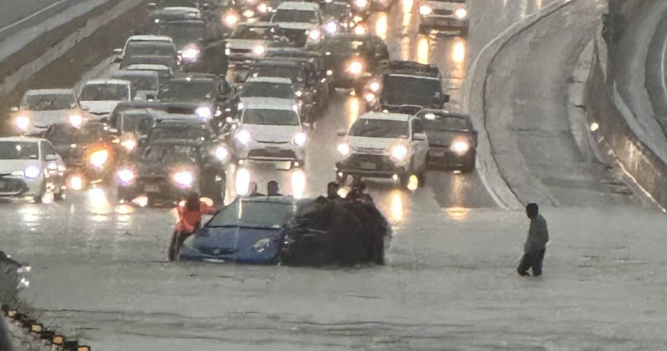
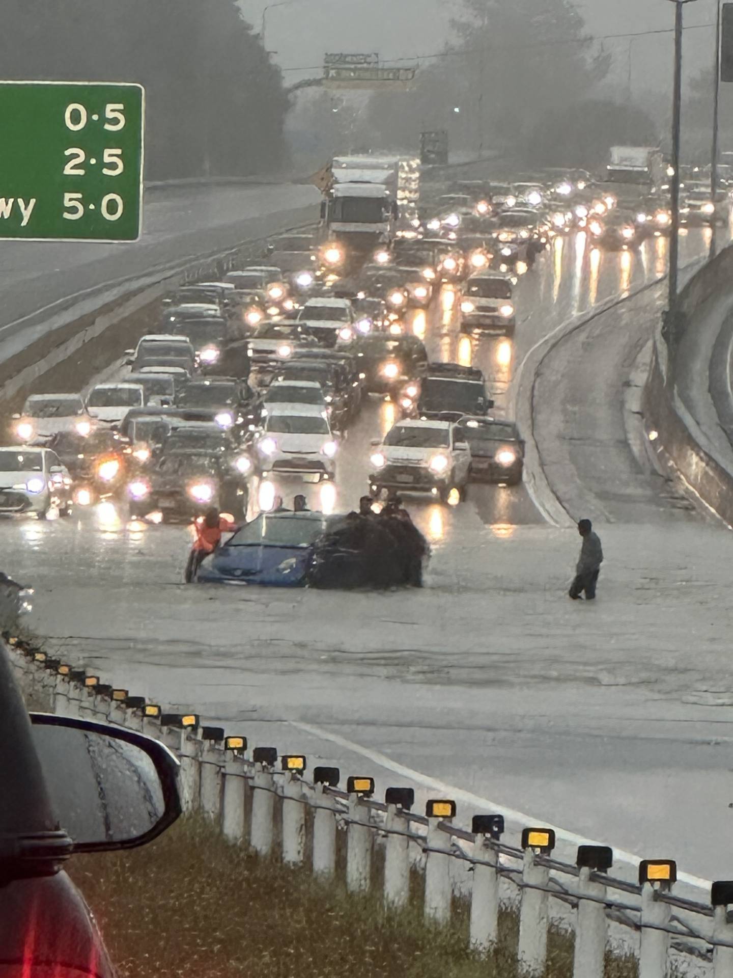
There! Happier now? But you have to wonder – or at least, I have to wonder – just how would we cope with a weather stream like this? We don’t need to wonder for long of course, as just before Christmas I recall we had a spell of non-stop torrential rain which broke heaps of records and caused lots of slips and destruction. Don’t tell me you have forgotten already?!?! No, of course you haven’t – nearly everyone has a nearby slip that either happened to them or happened to their neighbour, although I don’t think anyone actually drowned in Wellington’s imbroglio (no – wrong word, but I like it) cataclysmic inundation. We had part of the Terrace fall down and the road be closed for weeks on end. We had slips in the Hutt, probably both of them, and slips on the Kapiti Coast, including that monster slip on the old SH1 that they are still working on till the end of February. Serious stuff. As always, people with underground basements had them flooded out, which makes me wonder how come people in Europe and North America have basements, and yet don’t get flooded out?
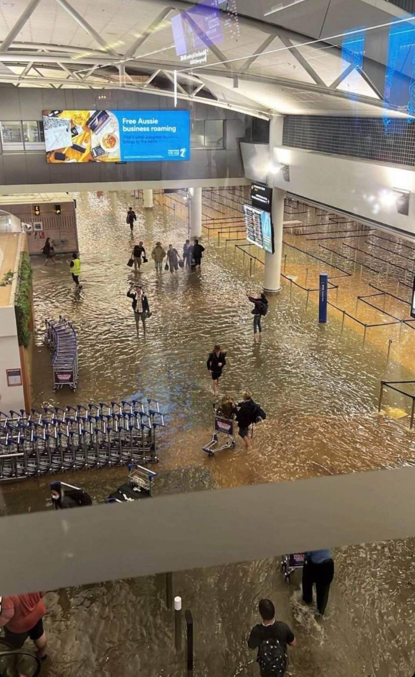
Still though, our rainfall event was a lot smaller than Auckland’s, or maybe it was a similar size but spread out for longer. 300mm is a lot of water to cope with, all at once, although to be fair, Fiordland gets that amount daily, sometimes, I believe. Back in about 2001 I recall we had 75mm in half an hour, and everything in central Wellington flooded, and there were cars floating about in a CBD basement – congratulations Volkswagen, you make a pretty waterproof car!
But the band of rain is headed our way and may be with us soonish. Most weird, humid weather I’ve seen for ages – hate to say it, but I’m dying for a bit of a breeze! Shall just have to continue to go swimming in the ocean, as that’s somehow more preferable to just having a cold shower. I like the crusty feeling of salt in my hair and on my skin, rather than just smelling of chlorine, as our water does now.
The real question, of course, is the big question – what happens if / when we get a deluge this size happening in Wellington? What is our equivalent of the Wairau Valley? We’ve got to remember that Auckland is a city built on 50 volcanoes, which means they have a lot of cold hard lava to build on top of. By comparison, Wellington has famously rotten rock, mostly greywacke, and the multitude of faults over the years means that the rock is already severely fractured. On top of that, our dirt seems to turn quite easily to mud, and let’s face it, a lot of houses here would slide merrily down the hillside. Where would all that water go to – and where would it all come from?
Well, history has already given us some helpful pointers of course. The classic instance is the Zealandia complex in Karori, with the Upper and Lower dams. Built over a 100 years ago in order to supply Wellington with water, Wikipedia tells me that they were decommissioned only in 1991, and the level of the top lake lowered to the very much lower level that it sits at now. It seems that at some stage prior to 1991, someone did their homework and figured out that if the hundred year old dam failed, and the water came down the valley, it would eventually exit out at Woodward Street. Some of you may know more about that than me – please write in or comment if you do – I’m guessing that it is a simple matter if we just follow the route of the Kumutoto Stream, as that is the one that comes down Woodward Street and out to sea next to that funny looking bridge near the Meridian building. I’m going to leave a blank here because I want to find a contour map and see if I can make sense of it.


Is it a myth that when the Karori Dams finally fail the water sweeps down and floods the Beehive Civil Defense Bunker?
Or is there any truth in it?
Not as far as I know, Mister Henry Filth, but tell me more if you know more ! Following the route on my Maps, it does not seem so – but also, wouldn’t they also have paid good attention to the waterproofing? Any water flow down Bowen Street would surely just wash down onto the junction at Lambton Quay, rather than slop up and over into the Beehive? Unless there are secret underground tunnels (government buildings, so there are bound to be some!), that lead directly from Upper Bowen St into Lower Beehive?
It wouldn’t go down Bowen street.. it would dive into the little gully beside it (Sydney street W) and come round past the back of the Charles Fergusson building,
flood waters could then gain access to the parliament underground car park via an entrance on museum street,
This assumes that Appleton park prevents most of it flowing through to Curtis Street and it pools and heads through the karori tunnel, then down Glenmore street.
Which building is the Charles Ferguson building? How do you know all this stuff?! I’m impressed!
Nemo, Charlie Ferg is the recently refurbed building near the end of Ballentrae Place, with the new 40 & 44 Bowen Campus now next to it, and Defence House/Bowen State Building in front (on Bowen).
https://www.google.co.nz/maps/@-41.2766662,174.7732956,75a,35y,142.07h,65.58t/data=!3m1!1e3
I heard it was the Aro Valley, followed by the refilling of the Basin.
From a brief look on Google Earth, it looks like it heads down Ian Galloway Park, Otari-Wilton Bush, and then down Ngaio Gorge before spitting out between Spotlight and the NZBus Depot in Kaiwharawhara.
Actually, you’re entirely right, that is indeed where it looks like it would flow.
So – where did the Beehive Bunker, Kumutoto Stream, and Aro Valley rumours come from?
Aro Valley would not flow into the Basin, in the traditional flow pattern, because of the hills like Pukeahu. Traditional water patterns tend to go diagonally across Te Aro down towards the waterfront – refer back to one of our previous posts: https://eyeofthefish.org/shaky-ground/
Gosh you guys are good. I was in the middle of writing that when I fell asleep last night – and pressed publish. I’m still working on that ! So far, I think you are all wrong – but hell, its more likely that I’ve got it wrong !! Off to do some more homework!
Unless the Karori reservoir (Zealandia lake) water can get through the Karori Tunnel its flow is restricted to head out under Appleton and Ian Galloway park ( The stream was piped and these were filled in as rubbish dumps) then via Otari Bush, Trelissick Park and Ngaio Gorge
Yep ! Seems like that is the only possible route…
Well, actually, basements do get flooded out in Europe when the big storms come. I was at a big sex party in Berlin one Summer – most of the action taking place in the basement floor – lots of dungeon rooms, slings, and a super huge vinyl bed in the middle, with a queue waiting to service a master figure. And, strangely, despite knee height flooding, everyone just carried on. Maybe that’s something about the efficiency of the germanic psyche – although there were a few Antipodeans looking concerned – as we do when being flooded. I think the architecture, design and resilience of sex clubs possibly deserves more consideration during global warming events. Rubber chaps are not the only answer – I fear.
Best reply comment ever… Madeleine, you take the cake. Probably by force, but still, the cake is yours.
I must have been thinking about the stuff on p34
https://www.google.co.nz/url?sa=t&source=web&rct=j&url=https://archive.gw.govt.nz/assets/Our-Environment/Water-Supply/PDFs/Our-water-history-on-tap-complete-document.pdf
“In 1979 consultants suggested the upper
Karori dam could also fail in an earthquake,
taking out the lower dam by domino effect.
With resulting headlines like ‘Karori Dam
Ready to Spew Disaster – Little Can Be
Done’, mitigation work followed in the
streets below, including the purchase of
four houses on Curtis Street to remove
them.245 Fear of the Karori dams bursting
had earlier led the national emergency
management headquarters in the Beehive
basement to be bunded against flood-
waters.”
I’ve been told that the Karori dams are fairly silted up so the total water volume might not be as much as you think – would like to hear confirmation/denial if this is true
In a heavy rainstorm event
SH2 cut off at Petone – Cornish St overload, takes out train services as well
Surface flooding Petone
Kaiwharawhara stream scours out at bottom of Ngaio Gorge – would need to be a big event for this
A big Southerly cuts off Eastbourne area
High winds will close Remutaka Hill Rd
Cars getting out of town will crawl along the Northern suburbs spine to Jville then TG
Back road Karori-Jville floods with meandering Makara stream going all over the place
Slips more in newer suburbs mainly because places like Khandallah and Korokoro have been built longer so have let go where they were going to let go
Riverside Drive in Waiwhetu usually floods
Keep about 150 synthetic sacks and make a big sandpit, even if you’re not a breeder
Funnily enough, stock up on water – a tray of half litre plastic bottles runs to about $11 at Pak N Save
One comment that you made several years ago, 60mPaa, here on the Eye of the Fish, that has stuck with me ever since : Always have a few sheets of plywood stashed away for emergencies, so you can board up openings and things like that. Great advice. But every time I have a stash, I find I use it ! Then have to go and rebuild my stash !
tell me about it
the other half always wants another dog kennel or firewood box or hay box for the horse
The other thing good for civil emergencies is about a grand in cash and a few slabs of heineken or similar
If you want a passing digger driver to clear your drain in the middle of an “event” then some beers will often go a long way to get favours done
Is the dam from the old Kaiapoi Woollen Mills still there up the hill out the back end of Cornish Street?
Good question – I can’t quite tell – there’s a building in the way !!