Hi fishes. Well the LGWM thing was announced supporting the big, most expensive package. As you know I got my issues, discussed in 3-Big-Flaws here. Thought I’d come back and address a few bonus thoughts. First up: The Gauntlet Tunnel.
To recap. The selected package aims for trams to Island Bay, frustratingly bypassing Newtown, and a busway to Kilbirnie and Miramar frustratingly attached to a new highway tunnel. The prior post showed there is really no good reason that this needs to be a busway rather than tramway, and no good reason that it must be via a new highway tunnel that routes the transit around communities rather than through them. In fact doing the opposite would get us more transit for our money as less tunneling is required.
I AM NOT A PROFESSIONAL TRANSIT PLANNER but as a general principal:
- Roads and highways should route around communities — move traffic around, not through where people live and are active
- Transit should route through communities — transit moves people to and from where they live and are active
With big crayons:
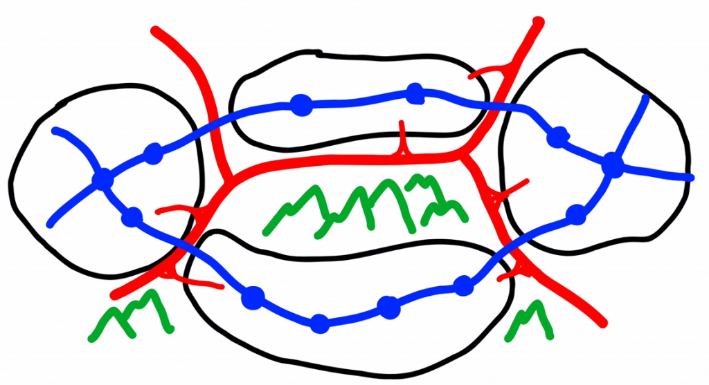
What the LGWM plan is doing is building an extremely expensive tunnel, for buses, to essentially provide an express link that does not improve transit service to any communities on the way. Transit has somehow, not sure how (AHEM cough sputter), wound up 100% coupled to construction of very expensive highway improvements.
In the prior post I showed that instead of building the twin bore tunnels in which two lanes are painted green for buses[1], if we decouple transit from the highway improvements we can simply build one of the tunnel bores for the general traffic and repurpose the savings elsewhere and get a better transit network by extending trams to Newtown proper, and through Mt Albert to the eastern suburbs. The same number of general traffic highway lanes is still provided, so there is absolutely no loss to SH1 capacity, so who’d be complaining? But we’d end up with a lot more transit than we otherwise get.
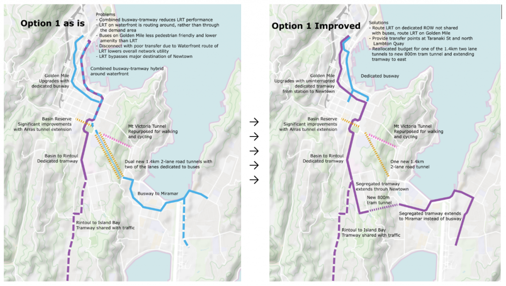
While I prefer this proposal — extending trams through Newtown and a smaller/cheaper Mt Albert tunnel to the east — and think it has more benefits. There’s another, even cheaper option.
The plan as it stands is to convert the existing Mt Victoria tunnel to full pedestrian and cycle use. Instead it could be converted to both pedestrian/cycle and provide a gauntlet track for trams. In past plans to duplicate the tunnel the elevated walkway that is built over the ventilation shaft on the northern side would have been demolished, widening the carriage way of the tunnel to over 7 meters. (All I know for sure is it was stated to provide at least two 3.5m traffic lanes in the original NZTA proposals, presumably there was some additional width beyond that, but if anyone has the deets let us know.)
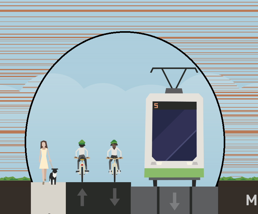
While this may be slightly less than ideal width for a cycle/pedestrian pathway, it’s not out of line with other pathways and it is after all a mostly win-win compromise that saves a lot of money by not building a whole new 1.4km road tunnel.
The gauntlet track through the tunnel would run approximately 700m. Assuming a max speed of 50kph, 1ms^2 acceleration/deceleration, entering from a worst case dead stop and exiting the gauntlet at 15kph, with a 20 second operational margin. A headway of 3 minutes is feasible, which is fine given the frequency could generally be expected to 5 minute headways due to being a branch sharing the tramway through the city with the Island Bay branch.
For nerdiosity I decided to model the two options. My preferred route via Newtown, and this route via Hataitai. Stops are just selected to be approximately 400m apart for the purpose of determining the segments for the model.
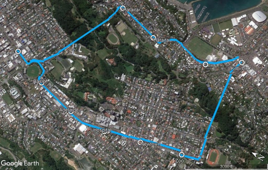
There would be about a 2 minute advantage in travel time between Kilbirnie and Kent Terrace going via Hataitai. And I’m going from memory here because I don’t have the spoons to go digging through archives of documents again: but I believe that is pretty much on the money with the model that one of the external consultants did for LGWM a few years back (I forget their name, if they read this sing out).
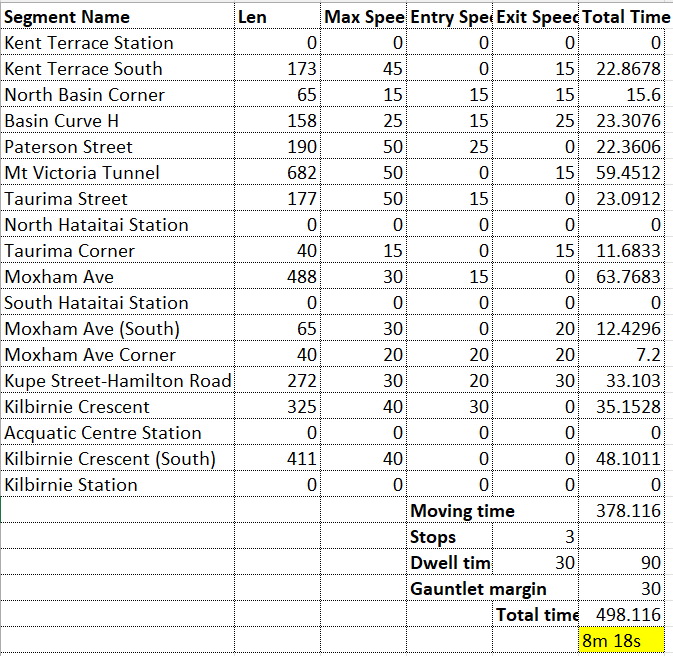
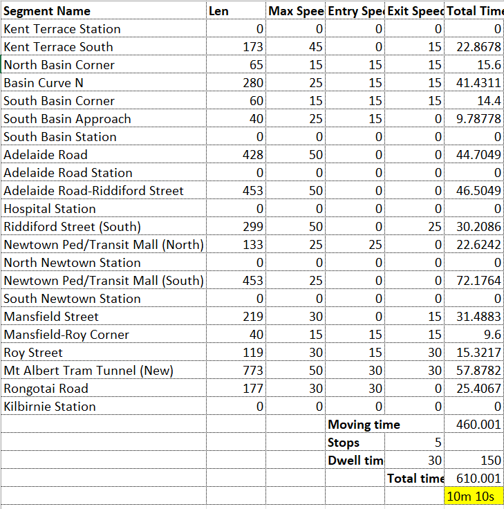
The Hataitai route would run fully separated from Kent Tce to Moxham Ave, presumably with a stop in Taurima St. Then it would be shared street running on Moxham Ave through to Kilbirnie Cres. There is some potential to provide partial separation (e.g. skip lanes for the trams approaching the intersections). A small amount of widening is also a potential in future, after all more housing is the goal so Moxham Ave cannot stay low density forever.

I believe there is room with some widening on the eastern side to run a separated tramway on Kilbirnie Cresent.

Is this better than the mixed busway/tramway plans currently being pushed? Is that worth it? Is this a better network than the tramway via Newtown? To my mind, given the costs savings it seems preferable to the bus-lanes in a new highway tunnel plan, and it’s very flexible to future enhancement:
- If the gauntlet ever becomes a constraint in some very distant future then nothing prevents addition of the new pedestrian/cycle tunnel (proposed in the other LGWM options) at that time, with full conversion of the Mt Victoria tunnel to two tracks, it would still be cheaper.
- Alternatively if we want more capacity, with a network that better services Newtown in future we can always add the cheaper Mt Albert tram tunnel at that time too.
- These options are there, left for flexibility in the future because we didn’t spend the money coupling transit to a highway.
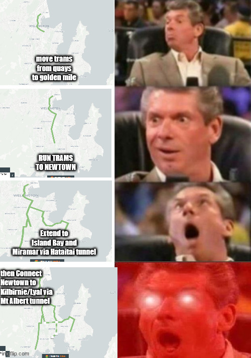
In meme format, what if:
Footnote [1]: Some would also speculate that these green bus lanes in the new highway tunnels will be progressively unpainted in future, oh taxi’s should be allowed cuz airport, oh HOV should be allowed cuz cars vroom vroom. You get it. But that speculation isn’t necessary to oppose it, since this is simply a transit design that makes no sense in the first place.



Welcome back Erentz ! Really appreciate you posting that. Now I just need to sit down and read it…
Tena koe Erentz!
Your meme game is extremely strong – wonderful translation.
Yes, I don’t get skipping the very thing you’re there to provide service for – passengers. Doy!
> Your meme game is extremely strong
Thank you ☺️ I put a lot of effort into making sure to misspell things and mix up the capitalization just right
I’ve got a few questions for you Erentz. Firstly, you start off by saying “The selected package aims for trams to Island Bay, frustratingly bypassing Newtown, and a busway to Kilbirnie and Miramar frustratingly attached to a new highway tunnel.” While I agree with you that having buses mixing it with cars on the way to Kilbirnie is a really dumb move, I’m puzzled by your first comment – “trams bypassing Newtown”. Don’t the tram lines go straight through the heart of Newtown? They appear to go right past the front door of the Hospital and down the road – not sure of the exact route yet, but certainly seems to be Newtown bound to me….?
But secondly, I really don’t understand why you (and some other people) are still promoting that it would be better to swap the LRT to the Golden Mile. The way that LGWM are planning makes sense to me – LRT needs to be fast to Wellington Station, and so needs to be in a relatively straight line with relatively few stops along the way. The Quays is perfect for this. The GM is for slower-speed Public Transport, like the existing buses – indeed, nothing much will change on the GM while they build the LRT. Makes sense to me. Why does that not make sense to you?
Alan, in regard to bypassing Newtown,
Erentz is referring to the route going up Rintoul Street ( so that it also serves Wakefield hospital on its way to island bay)
This means that it doesn’t go through the “core” of Newtown which is generally understood to include the Constable St intersection…
Hi Alan – regarding Newtown, that’s right it passes the Hospital, presumably with a stop there, then heads up Rintoul St where it becomes shared street running. So it bypasses the core of Newtown and the flatter areas of Newtown with the obviously greater development potential.
Regarding Quays vs Golden Mile, this is talked about in the other article linked at the top but maybe not well enough. The first thing to challenge/answer is the idea of: why should the primary objective be to optimize for fastest travel times between the south and the train station?
Because that is certainly what LGWM has done here. By my rough model it’d be about 406s from South Kent Tce via Quays vs 510s via Golden Mile. So a savings of 1m 44s travel time. Maybe it’s a bit more, that’s just what I came up with, but it’s not significantly more.
This is great, nice a couple minutes saved for the people who just want to get from somewhere south/east of the city to/from the train station. But are they the majority of the users?
Surely the vast majority of people arriving at the train station are heading towards destinations in the city. And the vast majority of people traveling from the southern and eastern suburbs are also heading towards destinations in the city.
So for the majority of our users we’ve now made the system worse, and decreased convenience by adding a significant walk time component with multiple intersections to cross. Most users now face a 200m-400m (let’s avg 300m) additional walk to get to where they are going. After first crossing between 2-6 lanes of traffic. That’s 214s at typical walk speed, say three intersections to cross at 30s each and you quickly end up with 5 minutes extra travel time for an average user vs the 1m 44s saved for the fewer train station bound users.
On top of that are the negative impacts this has on overall network design and the ability to transfer between the bus services that will remain and the new high capacity system that further reduce the convenience of using the wide system for trips outside of to/from the station. This was illustrated also in the original post.
Let me know your thoughts on that — (note I’m heading out camping for a couple days so future replies will be delayed)