
We tend to take technology for granted these days. No longer do we have to carry a spare pint of oil or a spare fan belt in our cars, no longer is it necessary to have access to a map book when we go to visit an old forgotten aunty. Nowadays, modern wee technocrats that we are, we’re surrounded by technology, and it just works, dammit, near perfectly, all of the time. So much so, that when on the rare occasions that it goes wrong, we make a big song and dance out of it. Like the cat that Keanu saw in the stairwell in The Matrix, it is just the tiny glimpse of something not quite right that shows us how much of reality we now take for granted.

Take, for example, Google maps. It has only been around for a few years, but already we take it for granted, that it is perfect, up to date, and always there. Google Streetview is much the same – even newer than Maps, and apart from the irritating and mind-boggling automatic deletion of features of all the human faces in the world within Streetview, it is staggering what we can see.

Even more mind-boggling is the new feature from Apple, with the 3D version of their Maps – this technology is incredible – in America, at least, it seems as though every building has been photographed, and built as a 3D object, and then mapped with the photos for a seamless presentation of a 3D city. So – this varies hugely from Google’s Streetview, where googlers drove around in cars capturing data. Here, in Apple land, somehow, and I’m not sure how, the entire building is built. We are yet to see if NZ gets 3D maps or just the 2D data when the iPhone 5 launches here in a week or two. Some of you with flash iPhone 4 may have already upgraded to iOS6 and be able to tell us: how is it working for you? Regardless: free from the effects of the renown Steve Jobs Reality Distortion field, there evidently haven’t been enough sackings for poor performance lately, because: Someone screwed Up!

Yes, as all you technerds out there will have noted by now, the software is not working perfectly. The maps data is not current – blame Tom Tom for that. Worse, teh mapping function does not always get it right – getting confused in the case of bridges especially, it seems. Witness the great chortle of delight from the PC / Windows / Android world, where anything that ever goes wrong with Apple is always taken as a chance for great mirth. Of course, as I am a die-hard Apple fan from way back (you do not want to know Just How Far Back i can go…), then I am not interested in sticking the boot into Apple. They have always been leaders in the game, and here they are again, leading with a new technology.

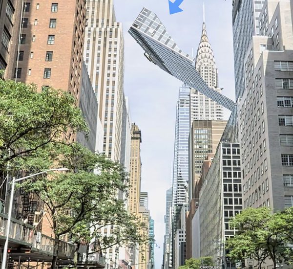
What is really interesting to me, however, is that some of these cracks in the Matrix are showing. We are getting to see through to the logic (faulty, it seems, at times) of the Machine behind the Matrix. The mapping software has been told to automatically model the maps onto the contours – but what happens when a bridge crosses high above the water map below? We see the resulting confusion of the machine trying to make sense of it – blurring the edge between two competing sets of logic parameters so it seems. Instantly, our human brains perceive the illogical impossibility, and those of you with Samsung phones are all chortling away in your cups – but quit your snorting for a second, and think of what we are really seeing here in these pics.

The days of having to find a data file of neighbouring buildings, and painstakingly build up a grey anonymous blob of 3D building are now over. From now on, with a bit of luck, Wellington will exist in 3D the same way that Washington does. People in Christchurch may even be able to see their city as it was, once more, complete in 3D, before it is updated and ruined virtually as well as physically in a post-Earthquake update (Google-streetview still shows the old city surviving, in both 2D and 3D, but probably not for long once the last red-zone barriers come down).


The maps are apparently just crap. They’ve even managed to lose cities the size of Brisbane: http://theamazingios6maps.tumblr.com/
I’m opposed to Apple because they’re trying to monopolise the web, preventing people from installing applications or even playing videos unless Apple gets a cut. I much prefer an internet that is open and standards-based. Apple fans confuse me with their willingness to pay more than they should for products that just don’t work, like these maps or iTunes. What are you people thinking?
Now then, now then, now then – I countenance no being rude to Apple on this blog. Mr P, did you not read my carefully crafted words above?
You said they were “leading with a new technology”. They’re not. They’re taking an existing technology and re-implementing it incompetently. They’ve misplaced Cairns by 100km, and have used the WW2 German-occupation place names for Czech towns rather than their Czech names. Those aren’t technology issues.
But, you’re an Apple fan. Do you camp out on the street for a couple of days like a homeless person so that you’re first in line to buy one of their overpriced computers? Like these people, perhaps?… http://www.youtube.com/watch?v=nf5-Prx19ZM&feature=player_embedded
davidp, considering Google’s decision to start charging high-traffic users of Google Maps API (Apple and websites which use Google Maps), can you really be pissy at Apple for not wanting Google taxing them on their mobile device use? Many websites have defected also.
Davidp – no, I’m not one of those mad happy campers in the street. I’ve never understood the mentality of that, whether people are lining up for days to buy a Justin Bieber ticket, or to wave at One Direction, or to be first to buy a new iPhone. That sort of behaviour is just plain uncool, and I’m way too cool to be doing that shit, baby. That saying though, I do like Apple products and always have. They have always been ahead of the game in so many ways, and other companies like Microsoft, Dell, Hewlett-Packard, Compaq, etc, and now Samsung, Huawei, etc are just copying – mostly badly.
But the purpose of this post wasn’t to be dissing Apple or others – yep, they’ve screwed up on the implementation of this one thing, but that really is just about the first. Overall I’m pretty pleased with the company. But I’m still blown away by the premise of what they are trying to do – I’d love to know if the software builds all the data on the fly from calculations etc, or have they really been round to every building in the US and built 3D models? I find that hard to believe. I’ve seen one post on the iOS6 tumblr you linked to today, where it showed Auckland – and the answer seems to be that we are NOT getting the 3D effect – presumably until someone builds a new 3D NZ for Apple to use. So, presumably, as San Fran has 3D and Auckland does not, it’s not software then. It’s people power and a heck of a lot of Sketchup. Even if that is still a Google product….
Dean… Apple charges everyone for pretty much everything. I don’t blame Google for wanting to make a bit of income off a competitor who has been bundling Google-provided services. It certainly doesn’t give Apple an excuse to turn the Czech Republic over to Nazis.
The video below (and the second part) sums up most Apple cultists I have met. Including my hopeless sister. I once spent a couple of hours on the phone to Apple support trying to get her new Apple wireless broadband router working. In the normal world, you just plug in broadband routers and they go. Apple’s didn’t. Their technical support was hopeless. I gave up after the Indian woman started to read out (verbatim) the setup instructions for a fourth time and I had to ask why she expected it to work when the previous attempts hadn’t. A guy from their Sydney office rang back later and explained that there was a strange undocumented setting you have to make for the particular ISP. Apple products just DON’T work.
http://www.youtube.com/watch?annotation_id=annotation_342699&feature=iv&src_vid=kTTSsB92L_s&v=FFhjDX-DUew
>I’ve seen one post on the iOS6 tumblr you linked to today, where it showed Auckland – and the answer seems to be that we are NOT getting the 3D effect – presumably until someone builds a new 3D NZ for Apple to use.
Didn’t I see something in the news a few days ago that the NZ government are going to make such a 3D map of the country? Terralink were involved, I think.
Regarding Auckland, people are also annoyed that Apple have relocated the railway station in to the harbour: http://www.nbr.co.nz/article/apple-maps-mocked-ck-129215 That is a surprise mainly because it is well known that Auckland doesn’t have trains. On the other hand, Aucklanders will enjoy ready access to Bondi Beach, which is now located just south of the Auckland CBD: http://www.nzherald.co.nz/technology/news/article.cfm?c_id=5&objectid=10836142
“I find that hard to believe. I’ve seen one post on the iOS6 tumblr you linked to today, where it showed Auckland – and the answer seems to be that we are NOT getting the 3D effect – presumably until someone builds a new 3D NZ for Apple to use. So, presumably, as San Fran has 3D and Auckland does not, it’s not software then.”
I don’t believe for a second that this is done by manual labor. Much too expensive and of course totally uncool for this day and age.
The images were taken during fly-overs and stitched together. Not sure why you think that every building was modeled in 3D. The reason there are no maps in NZ is that they either haven’t gotten around to it yet (or have legal issues), or that apple does not think it’s worth the money.
davidp, I am sure you can find stories like yours just about any product or large company. Not that I want to defend Apple, just saying that one story isn’t enough to justify the sweeping statement you are making. And, no, I don’t have an iphone.
D.
Diessoli – thanks for that clarification. I’m sure you’re right – but I still don’t quite understand – I agree that it is highly unlikely that anyone would have gone and built those models manually – but then again, if you look at the very top picture, you can see that even the simple houses at the bottom right appear to have a 3D structure – which suggests to me that this is just a software button – a very clever one, as it can build a gable or hip roof on the fly. Even the trees are recognized as 3D objects.
So what I’m saying is, if that happens automatically with the software, how come it does not appear to be happening here in NZ? The photo of the melting tower, third from top, doesn’t look like a major landmark in a major metropolis, yet all the menial buildings in the foreground look very 3D. Regardless: having had to try to build cityscapes on cad before, I’m impressed by this technology. In another year probably, all these glitches will be cleared up, and the software will just work, and we won’t even notice. Of course, Apple is going to need to do something before the year is up… and going back cap in hand to google is probably not an option any more…
“if you look at the very top picture, you can see that even the simple houses at the bottom right appear to have a 3D structure”
Jump to about 40min to see how google is doing it
http://www.youtube.com/watch?v=HMBJ2Hu0NLw&feature=relmfu
It’s sufficiently non-technical and vague that I would think this is also how apple is going about it.
“So what I’m saying is, if that happens automatically with the software, how come it does not appear to be happening here in NZ?”
Because they haven’t done (and might never do) the special flights necessary. They are not using existing aerial or satellite photos, but have to create them themselves. Like the google-streetview car trips this will be only be done bit-by-bit, I would think. Given the amount of privacy controversies streetview caused in some countries, the discussion around the flights will be interesting.
I am wondering if apple and google each id their own flights or if they shared the material. What an annoying amount of air traffic that must have been.
D.
From that article davidP linked to in the Herald above:
“Q: Which Maps app is the best then?
A: No mapping and navigation software is totally reliable, but some are better than others: in the above safety test, an Android phone with Google Maps listed the public hospitals correctly and so did the Nokia Maps and both of these offered clinic locations too.
However, Bing Maps on Windows Phone 7.5 had a meltdown and suggested hospitals in Uruguay, Spain, and Ireland after locating the device in Auckland with the GPS.”
So: it’s not just the Apple device that has issues. But no one seems to be making a fuss about MicroSoft Windows screwing up just as big as iOS6….
“But no one seems to be making a fuss about MicroSoft Windows screwing up just as big as iOS6….”
Does anyone use it (Bing or Windows phone), to actually notice it doesn’t work??
http://anthonydrendel.com/blog/2012/9/24/ios-maps-and-china.html
and also…
http://www.stuff.co.nz/technology/digital-living/7727326/Apple-Maps-moves-Dunedin-Timaru-airports
Bing maps was pretty funny when they launched in NZ — as far as I could tell, they had _every_ island mislabelled, including such minor ones as Waiheke, Stewart, Kapiti…
It was a bit better last time I looked, but Matiu/Somes was still wrong. And I can’t check today, because it seems to be entirely broken (loading MapControl.js failes with an HTTP 500). Oops.