
Unfortunately, not a post on the OK brilliant dance band and video “Here It Goes Again” but instead we launch back into commentary on the most tedious slow-motion screw-up that the Western World has ever known. No, not Donal Rump’s plans for global domination on the dance floor, but instead the re-emergence of the looooong-running saga over the Basin Reserve and the motorway from The Terrace to the Airport.
I didn’t think it could possibly get any worse, but I was wrong.
There will not be any true consultation, but instead some “open days” for explaining how/why theNZTA Traffic Engineers have messed it all up for yet another decade. I think it shows the very good reason why nothing should ever be designed solely by Traffic Engineers – this is yet another abortion of a design.
At least last time we had the full gamut of 57 paid-for “independent consultants” sucking on the NZTA teat and producing some design, no matter how badly flawed it was (and boy oh boy, was it ever flawed!!!) but here we just have roads and more roads.
There should also be some logic in here as well, but if there is, I have not really found it yet. Just roads.
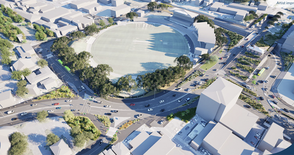
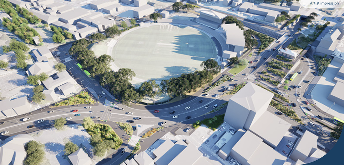
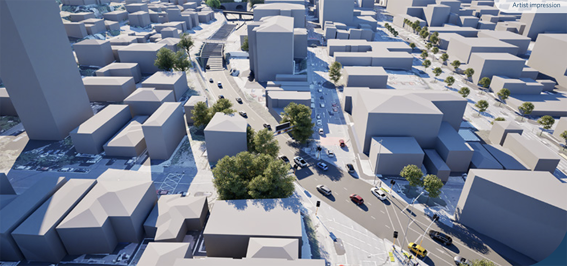
Its a little too much for me to cope with right now, so I am just posting some of the NZTA pix up here, especially round the Basin. That’s the same Basin which is easily solved without making a mess, although NZTA seem intent on making it a massive cluster of …. look, I dunno. How could they get this so wrong, AGAIN?
Somehow, while NZTA has had the last 10 years – 14 years? – 20 + years ?!! to get this right, they seem to have made some basic bloody errors that a four year old could solve, and have instead produced a design that is bound to rile up just about everyone in the community that it passes through. Just like last time.
Instead, of course, that this is NOT going to be like last time. Last time there was a Public Enquiry and members of the Public could voice their concerns, and ultimately the members of the Public showed that the NZTA Scheme was badly at fault and was not worth proceeding with. This time, no such luck.
The way that National have stacked the odds this time, the project will be on fast track and will happen whether we like it or not.


Appalling 20th century failed thinking by an ideological government intent on punishing us for having the temerity to vote in two Green MP’s. No Mandate, No Consultation for No Gain. $5 billion, Loss of Town Belt, Loss of Housing, Dubious ‘Project Benefits’ Increased flooding risk to shift a “bottleneck” to Kilbirnie..Crazy!
Hi Jimmy – yes, considerable loss of housing, not just up Paterson St, but also along Sussex St, and Wellington Road / Ruahine St, and possibly some other areas I have not noted yet?
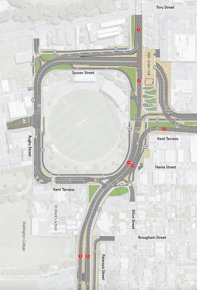
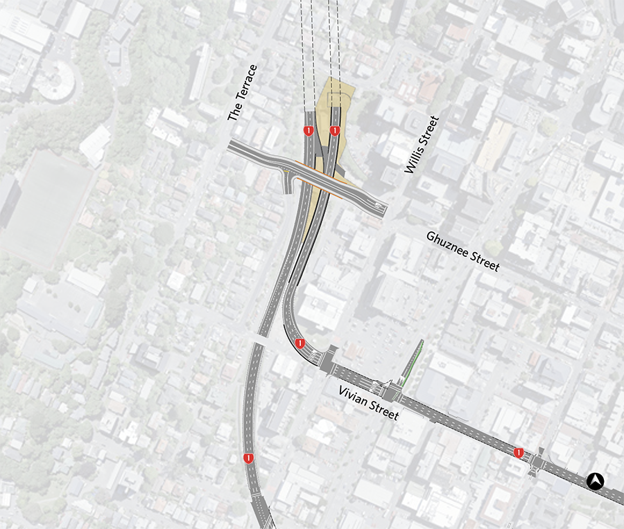
The traffic/pedestrian/cyclist “conflicts” at the Northern end of the Basin Reserve are truly impressive,
I love how they appear to have designed a road layout that will mean SH1 westbound will basically grind to a halt at every morning and evening peak as cyclists/pedestrians cross the road to travel up and down Cambridge Terrace, – let alone whenever there is a cricket test on….
Agreed Greenwelly – but let’s see if we can suggest a better way to the NZTA people. I hate having to do this, as it is their job, but I’m happy to publish alternative proposals if they can be shown to work…
I so much almost always agree with you Nemo…Crumbs what kind of a city will we be??
Nicest thing you’ve ever said to me Helene… thank you !
That stuff round The Basin is complicated. That means it’s probably wrong. But hey – what do I know?
No, you’re right, it IS bad…
Over on Scoop Wellington there are some people asking: “to what Standards is this being designed to?”
It is a fair question, and one that I do not know the answer to, but my uneducated guess is: Designed to the AusRoads Motorway standard.
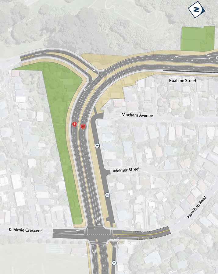
Have a look at that 3rd panel up from the bottom, a map with Moxham Ave coming in from the right hand side – is that not a curve for a 80kph curve, to be taken at speed, rather than something more like what we have at present, but which cannot be taken faster than about 30-50kph. Yes, it is an ugly awkward corner at present, but I bet no one dies there at present. But with that big sweeping swoop round the bend, fatal crashes are bound to risein a clash between people and cars…
Its certainly a faster sweeping curve,
For traffic heading into the city, the left lane, is impacted by cars coming from Wellington road, who will stop at an almost T junction, there is no merge for them and they will likely be traveling at very low speeds, … (despite there being huge “yellow” areas that could be used for a more sweeping curve …
however further toward the tunnel the new “netball” on ramp has a 100m distance to allow cars to “get up to speed”
And then they come out of the tunnel into the disaster that is the northern Basin reserve… with two sets of light controlled junctions, and a likely potentially long tail back of traffic wanting to turn right onto Cambridge Terrace ( but throttled by the Kent terrace traffic and the two pedestrian/cycle crossings at 90 degrees to each other….(it would be interesting to see what the daily traffic count through here is modelled at)
Why are you so harsh on it? What is wrong with the scheme? If it is so bad, then why don’t you show us a better alternative then?
If you had a little more knowledge of this saga AT-AT, you might not be so flippant. A better scheme has been proposed and I have a feeling Nemo may have been involved. It is called option-X, look it up.
Not me Pedge, that was all by the Arch Centre. But I do like it.
Thanks for your feedback AT-AT. What is wrong with the scheme? Interesting question – I would have thought that was self-evident, however, I will try to explain.
Firstly – there is an awful lot of roads, and a huge amount of intersections. Roads = more traffic and intersections = more potential accidents
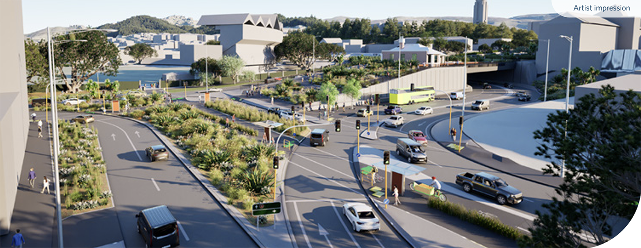
Secondly – I’m really puzzled at the logic (ill-logic?) of entering the Arras Tunnel by going UP a hill, over the top of another road, and then down into the Arras Tunnel. Surely, surely, a hundred times surely, it must be easier to have Sussex St go OVER the top of the SH1 road, and for the Arras tunnel slope to just continue down towards the Basin.?
Thirdly – that area at the end of Kent/Cambridge Terrace is just a total clusterfuck of roading intersections.
I mean, seriously?
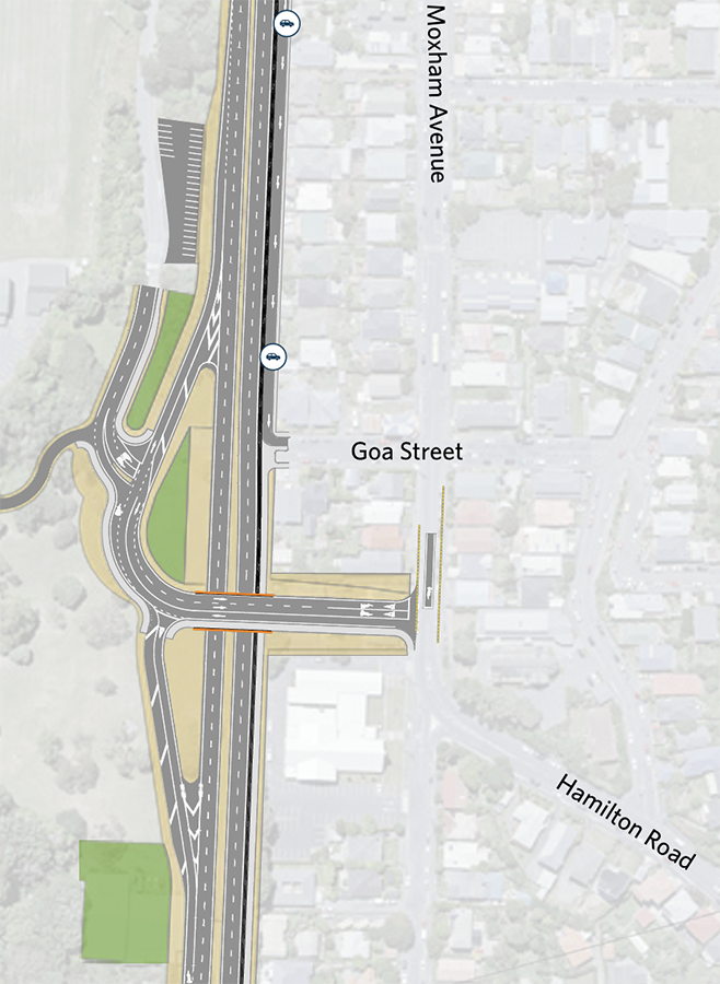
Fourthly – that Goa Street intersection – that is worthy of a high speed motorway interchange. This is a small residential street. Just seems crazy over the top response by a team concentrating on motorway design, instead of humans.
Fifthly – three lanes down Vivian St – not needed and really REALLY not wanted. Two lanes is plenty.
Sixthly – there are many more, but that will do for starters. Does that help?
I guess that one of the issues for me is that this is a scheme that has proposed answers that give Car and Truck drivers every single option on earth to go where they want to, but has not been so rewarding to other users. The thing about walking, is that people want to go in a straight line from point A to point B.
But the thing about cars is that they have a whole pile of horsepower that can do the A to B thing, but will take them via C and D to get there, and THAT IS NOT A BAD THING in my book. Cars can easily take a slight detour.
If I was a traffic engineer, and happily I am not, but I would start by designing for the Peds and the Cyclists and the Public Transport first of all – as they actually ARE the most important – and then cars, vans, taxis come later.
The Architecture Centre’s Option X video looks quite good as a starting point. It lives here:
https://www.youtube.com/watch?v=c9rS_oop78k
But I suspect that there will be a few fish hooks in the way of footpaths and bike lanes and school access. Time will tell, and I wonder how many of us will live long enough to see the final outcome
Option X and what we have are very similar, except the current proposal goes under not over the arras tunnel traffic,
Option X looks cleaner because
a) It did not have to include the cycleway , which was not there at the time
b) Removed the Tunnel traffic turn into Cambridge Terrace,
c) Turned Dufferin street into a stub with no SH! access,
I think the main focus should be on the Basin/cycleway/Cambridge terrace conflict, – solving that would remove a bunch of conflicts and make the outcome much smoother,
That’s what I was thinking. The core Option X concepts appear sound, and are baked into this scheme. If the pedestrian and cycle conflicts could be resolved at the end of Kent and Cambridge it might be on to something.
Would it be crazy to suggest a wide city-to-sea / highline style pedestrian and cycle ‘flyover’ that feels like an extension of the ground plane, that gently raises up from the centre of Kent/Cambridge, meets up with an extension of the same from the east and west (as suggested by the existing topography), and then lands atop the grassy hillock around the side of the basin?
It would at the very least be a fun inversion of the previous flyover scheme, and give dramatic views for the public down the Kent/Cambridge axis as well as over the basin reserve. The resulting quality of the space under it would be much less of a concern if it’s occupied just by cars.
Putting all the roads underground would obviously be better, but I understand not possible due to it being mostly water down there.
The entry to the schools and Government House should also be massively greenified and read as a public plaza, not as a through road.
A raised pedestrian plaza over the roads and connecting the basin reserve to the central greenway of Kent/Cambridge could also be a really, really grand front door to the basin reserve, and provide a suitable termination to what is Wellington’s only proper axial arrangement. I think we should draw this up…
I don’t understand the predilection for having everything at ground level. It simply means that there’s always someone waiting for someone else.
For pedestrians and bikes, raised overbridging is a pain in the *rse with stairs and ramps and extra bonus wind, while underground is generally a pretty p*ss-p**r experience, so stick the traffic underground out of everyone’s way.
Or simply re-locate the Basin Reserve to Civic Square – I understand there’s some free space there going cheap. . . .
Imagine if a future government wishes to invest in a mass rapid transit service to Newtown and beyond, as agreed in LGWM until the current government scrapped the plan in favour of a roads-only design. How will the north and south MRT lines get across the east and west lanes of SH1? Or will the design prevent future light rail or other mass rapid transit services?
I’m guessing future proofing for MRT that was part of the reason the N/S traffic (Cambridge Terrace-Adelaide Road) now remains at ground level and the Arras Tunnel traffic goes over it,
The original LGWM plan to raise the road over the Arras Tunnel would have required large numbers of buildings around Barker street, to get the grades low enough for a rail based MRT…
Hold on GreenWelly – not sure what you mean there. Can you explain please?
Isn’t the Basin Reseve section very, very similar to Option X? It has borrowed all the key concepts, just with what looks like maybe a few too many lanes and not enough emphasis on green space, public space, pedestrian priority, and future rapid transit. But the core concepts are there. Could it be massaged into something that is actually quite good? Especially compared to the previous flyover option.
Jesse – just for you, there is a new post up, that you might like. All about the options.
This “new” design (2025) has Kent/Cambridge terrace traffic go under the Arras tunnel traffic (SH1)… ie remain at the same level.
This makes it easier to put future light rail up to the Hospital etc by just taking over an existing lane that now remans at the same Height of Cambridge Terrace
If they had put the Arras tunnel traffic (SH1) under, (with the Kent/Cambridge terrace traffic on top) like the LGWM solution they would have to knock down pretty much all of the buildings on Barker street to get an acceptable slope to get the traffic from Kent/Cambridge terrace up to the height of Tory street , (even more would be likely needed for any LRT with a lower acceptable slope)
This was one of the reasons they kept looking to run the MRT up Taranaki Street, – it is higher than Cambridge Terrace…
Greenwelly – have a look at the new post and see if you can still get a train through there.
Goodness me. Chris Calvi Freeman pulls no punches.
https://www.thepost.co.nz/nz-news/360891378/transport-planner-gives-nzta-wellington-plans-fail-i-just-dont-think-nzta-has-tried
I think we need to Hire the the Japanese now. They know how to do Infrastructure better than our own people.
Well, yes, you’re correct, but it is not just the Japanese doing better than us at Infrastructure. There is some evidence to say that actually all English-speaking countries are crap at this. America. England. Australia. Canada. Aotearoa. No-one has any actual real reasons why this should be so, although I suspect that it may be tied to the rise of the cult of the OSHA, and the PM who knows theory but not reality or practice! But actually, countries like Spain, Portugal, are very good and cost effective. Much better than us.
Japan also great but possibly not so good at affordable by NZ bank-balance standards? And I would have put China on the good list, but having watched that brand new concrete bridge in China disappear in a puff of smoke as the mountain fell down, I’m really not so sure about them any more…