
Let’s Get Welly Moving is the regional agency based collaboration, tasked to sort out Wellington’s transport woes. It follows on from the debacle over the failed Basin Bridge proposal, when NZTA decided we would have a “choice” of Flyover A or Flyover B, and both WCC and GWRC sat on their hands and pretended that the problem was “nothing to do with me, mate.” Let’s Get Welly Moving (hereafter referred to just as LGWM, but composed of TLA or FLA like WCC, NZTA and GWRC) is due to report back to New Zealand in the next week or so, with some hopefully brilliant solutions to our transport issues. Fingers crossed.

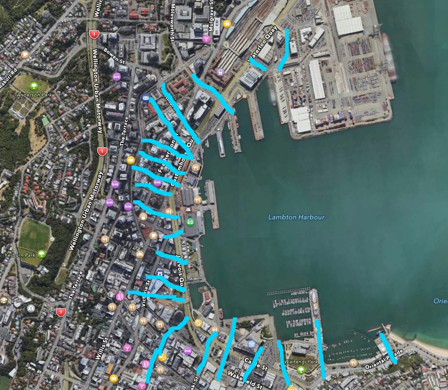
(Red = the cars and trucks choking up the city)
Of course, the great thing is that LGWM has actually done some half-decent consultation this time, instead of the pretend “consultation” that NZTA did last time. I want to stress that it is not the fault of the people – it is the organisation that screwed up. I have ended up meeting various people involved in the failed NZTA bridge scheme, and without doubt all of them were really nice and you can have a good conversation with them off the record. Well, perhaps not Selwyn Blackmore, who really seemed to swallowed the party line hook and sinker, but most of the other people were great. Many of them were consultants from other companies, and most of them have moved onto other projects – some to the Transmission Gully project, some to Auckland projects, some perhaps to a Cycleway – anywhere a bike is welcome (obviously that excludes the toxic Island Bay charade). But I digress. Where was I?
The half-decent consultation was a little too simplistic and patronising but did at least give some impression of being interested in hearing what your opinions were. It was cleverly worded so as to never say “what do you think about our last idea for a flyover, eh?” and nor did it say “would you like Option A or Option B?” but instead it said “How do you get around, mostly?” and “What do you like to do in the weekend then?” etc. No question to which you could say “I’d like flyovers with that please” nor “No cycle lane to Island Bay thanks.”
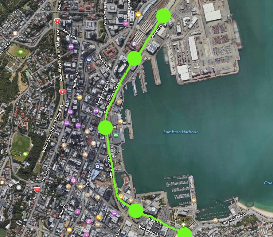
(Blue = the pedestrian paths of people wanting to get down to the harbour side – as you can see, this really conflicts with the red lined map above)
What we here at Eye of the Fish are hoping for is that LGWM will offer up some genuine decent strategies for Wellington’s transport, and top of that list, for me, is a decent Public Transport spine. It has become crystal clear for me over the last few years that the answer to our transport issues is not more roads, but lies in a solution with metal tracks, separated from the ordinary road traffic. The three “options” originally talked about (bus, bus rapid transit, or light rail) in that badly written, badly stacked report from accountants Price Waterhouse Coopers (the same idiots responsible for the Oscars cock-up) were clearly answers to the wrong question. You can’t have an Bus Rapid Transit going down the same roads and through the same tunnels as ordinary cars and trucks, or its just not BRT then – its just Buses. That’s why, three years down the track, WCC have made no moves towards having a BRT anywhere. Zero progress. Nada. Zilch. Zip.
The crucial point is not, for me, the Basin, but instead it is the interchange at the main Railway Station. Grand Central, if you would. At present, as you know, all trains stop together (brilliant) and all buses start (via a short tunnel walk away). Personally, I think that needs to change. Personally, I think there needs to be an interchange to another line which can continue on, down through the City, through Te Aro, and on to the Airport. That needs to be the total, absolute minimal starting point for any city transport planning. No arguing, no prevaricating, no more pissing about – just bloody well do it.
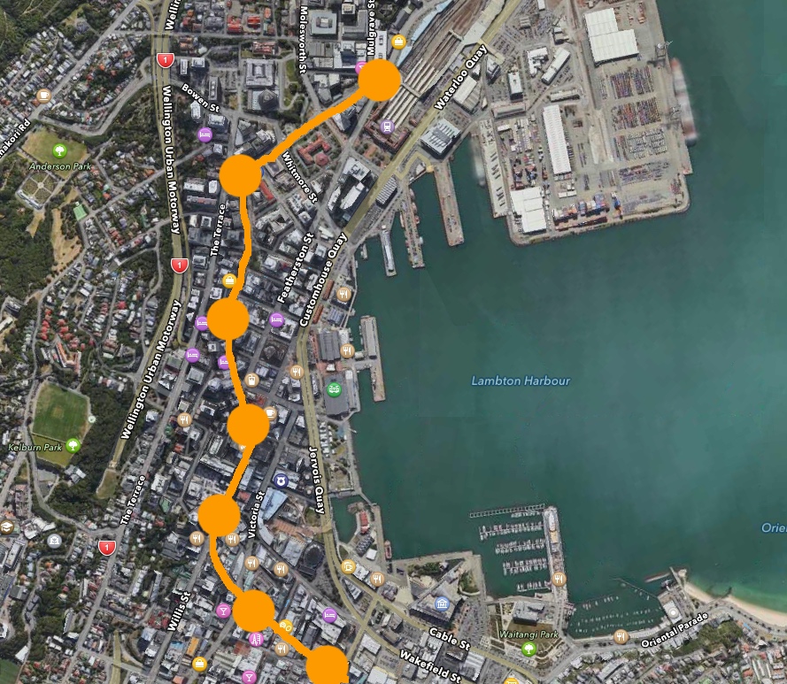
(Green = Eye of the Fish says “Light Rail here, NOW” – straight and fast)
The interchange is the key to making this work. At present, everyone disembarks from the trains, theres a bit of faffing about getting off the trains, then the walk through the subterranean tunnel, and then the wait for the bus in cramped outdoor conditions. Some people walk on from the station, some wait for a bus, some get a taxi. But not everyone really wants to leave the train there. If only we hadn’t axed the Te Aro Railway line back in the 1920s! The key, to me, is that a new line (whether heavy rail or Light Rail or Tram or Train I don’t really care) needs to be on a separate alignment so that it cannot get blocked by cars (nor block cars itself). It needs it’s own corridor, and services need to be swift, steady, two way, safe, reliable, affordable, integrated, and frequent. I’d propose that a new station be set up about near the Stadium, where all lines could safely stop, and let passengers cross seamlessly directly across a platform, and the Light Rail (let’s just call it that for simplicity’s sake) can then descend down, under the main urban road (Aotea Quay) and up on the other side. Next to Centreport’s sorry sad piece of land. But crucially: uninterrupted by traffic. Whether above ground or below ground or at ground, I really can’t say, and again, I really don’t care, but I strongly believe we need a route as straight and direct as possible. That rules out the labyrinthine route weaving between the Lambton Quay office blocks, especially at Stewart Dawson’s corner, which has been the sticking point in this city’s plan since about 1840. You would need to have probably only 2 or 3 stops in the city – one at the main Station, one near Te Papa, and one somewhere in the middle. From there it would sail on (ok: speedily rattle on) down to the bottom of Courtenay Place, then curve round to speedily track down Kent Tce, under the Basin, on to the Hospital, and thence either up the hill or under the hill, over to Kilbirnie and onto the Airport, perhaps even doing a giant turning loop under Miramar and picking up those legions of Weta workers. It really is that basic and that simple. Do that, and we can save Wellington.
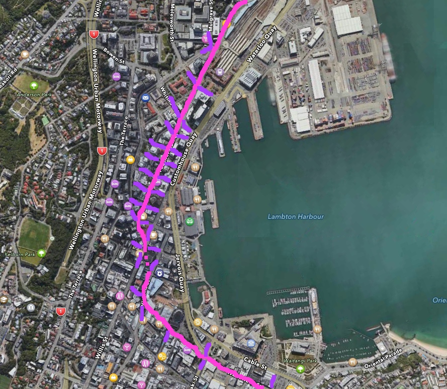
(Orange = current Bus route, and future bus route too – slow, congested, and a pain in the ass)
The importance of doing this now is that in 4 years or so we will have a giant superhighway of cars heading into the city from the Kapiti Coast via Transmission Gully, and as the city won’t be able to handle the flow, they WILL clog up and cause havoc. If you’re stuck in that inevitable traffic jam (there’s nowhere for them to park, either in parking buildings or on the street) then you’ll be fuming – but if we have a LRT system in place, we can speed by and laugh. We need a system that can work in the future when the oil (eventually) runs out or when electric cars litter the ground (cars are still cars – they will still congest the city, whether petrol, diesel or electric), and we need a system that can work when the harbour is one or two metres higher. We really do need to plan for these things right now, while we still have a clear path and we still have time to plan.
So: anything less than grasping this particular nettle by the stalk, like I have above, and LGWM will be a costly failure and a waste of time. We need a solution for the future: for all possible futures. There’s mine: what have you come up with LGWM? Time to show and tell!
Post-script 16 March:
Following William’s comment below, I’ve drawn up a version in Pink (with Purple bits) to show the clarity of the route down Featherston St (and also the potential clashpoints / crossroads in purple).
thats exactly whats required, and like highway projects doesnt need to be built all at once but in stages, 1 – station to te papa, 2 – te papa to basin, 3 – basin to hospital etc.
I’ve got my fingers crossed for a mag-lev monorail from Karori to work…
more than one seat m-d, or is it just for you?
As noted above, the interchange is the key. Transmission Gully highway is the problem. Massively more cars trying to come into the city will be a huge hassle, and can only be realistically met by having an equally better Public Transport system BEYOND the current Wellington Central Railway Station full stop. Expecting everyone to get off, all at the same stop, and walk sideways and wait for another mode of transport adds up to too many “too hard to haves.” But having an overlap of Rail system 1 and Rail system 2 is the ket solution – and the earlier the better. So you’ll note that on the brilliantly drawn graphics up above, that the first Green line stop is not at the Railway station, but before – I suggest the Stadium. That way, also, Light Rail can cross the road to the seaward side, and then, as Luke says, on to Stage 1 – to Te Papa etc.
Probably worth noting the key points that the Let’s Get W…. team have pronounced so far: in their optimistically titled “Progress Report Feb 2017” they say that they are focusing on:
2. People first
3. Comprehensive Data collection
4. Wellington growth and travel patterns
5. Defining the problem
6. Finding a solution
So you’re way ahead of them…
Thanks Alan. Well, while I may be up to stage 6 already, I’m leaving 2, 3, 4, up to them – and I think we all know what stage 5 is already.
Of course, if they come back and say the answer to 6 is a Flyover, then be prepared for blue bloody murder !
Definitely yes for rails of some description, however I’m going to suggest a different central city route.
Run it on Thorndon Quay from north of the Railway station (where the interchange would be), along Featherston St (which becomes public transport & bicycle only), onto the short southern section of Lambton Quay, through Willeston St (both ditto no private vehicles), and onto Jervois Quay.
The advantage of this route is that it puts it closer to the middle of the area where people work and shop rather than out to the east side. It would be more attractive to occupants of buildings on The Terrace (where there’s significant parking available so walking a greater distance to the rail would be less competitive with driving). Your plan has most passengers having to cross one of the three quays (which are busy roads) to get to their destination.
Similarly, to make it closer to Courtenay Place, I think Wakefield St would be preferable to Cable St.
There have been previous suggestions of continuing light rail through to Johnsonville, that could eventually be achieved by connecting through to the rail tracks where Thorndon Quay borders the railyard (opposite the fire station).
With the south end of Lambton Quay closed to private vehicles, the rest could become a pedestrian zone or a shared zone with vehicles only accessing from the north end.
To your list ” swift, steady, two way, safe, reliable, affordable, integrated, and frequent”
I’d add “take precedence over other traffic”. Without that your swift and reliable will not be achieved.
That’s an interesting proposal William – and yes, for years I have thought that Featherston St was the right answer too. It is, as you say, in the middle and therefore readily available to people both from Lambton Quay and the Terrace, as well as from Jervois Quay and Customhouse Quay and the Waterfront. Also, as you point out, it would be best without any car traffic, so make it PT and bike only. So far, I’m in full agreement.
I guess where I am coming from is that if a PT route was situated on the seaward route, you’ve got virtually no cars crossing over the tracks and so therefore no hold ups for the Light Rail / Trams. No danger of cars getting stuck in the road / no danger of trams getting blocked by cars. Therefore, swift, steady, safe, reliable etc. So then the PT / LR can run faster, hence making it more popular. The only other route without crossovers would of course be Lambton Quay itself. Anything down the middle, while more popular and accessible by pedestrians, risks being held up by more congestion from both cars crossing East-West and / or people on foot.
So what is the answer?
Swift, steady, safe, reliable etc are worth nothing without passengers on board. The concept of Desire Lines is equally applicable to where people want to get on and off, so the route needs to meet their needs.
Regarding being held up by crossing traffic, both of our proposals are a straightforward single route. With the centrally co-ordinated traffic light system that Wgton already has it must surely be simple to organise things so the lights go green for the Light Rail / Tram as it approaches, or to at least minimise any wait.
Your concern about Featherston St having more East/West traffic crossings is a very good argument for fully pedestrianising Lambton Quay. There will then be no through traffic, only access to the buildings on each street.
And let’s not forget that a succesful system will reduce other traffic so the conflicts are reduced anyway. Attitudes to public transport in Wgton are already good, that’s a good base to grow from.
I think to add on to William’s concept, make every second crossing road pedestrian-only (with flexibility for delivery vehicles to use as well, but not cross Featherston St).
In conjunction with the traffic light timings at the clash points (for now half the instances), this would make the tram/LR journey much faster.
i prefer along the harbourside of the quays to avoid turning traffic from next to bluebridge with a pedestrian subway similar to the bus one, then cross cable st with priority at lights cut thru new world carpark and down a pedestrianised blair st for stage one.
Every time you have to have a tram slow down and wait for a car to cross, the entire system gets delayed. Then its not Light Rail any more. Its just a StreetCar service. No faster than a car or a bus. If you want people to use it, it HAS to be faster, smoother, reliable.
Maybe the answer is not to install at street level, but go either UP in the air, or Down underground. One rattles and blocks your sunshine and creates noise. The other option costs miles more, but never gets blocked, although could get flooded…. Thoughts?
Hmm.
Digging underground through the old foreshore, earthquake uplift and random landfill dumps? Sounds like the set-up for a disaster movie (do they still make those?)
Overhead makes me think of the Chicago El – but also the Springfield Monorail. I watched them dismantling the last pylons of the Sydney one a few years ago. Didn’t look like value for money to me.
Why not driverless light rail units on auto-timers which send them unerringly through the intersections on green waves? The only delays would be for those silly old-fashioned driver-operator cars in the cross streets.
A Streetcar Named Te Aro.
This is very interesting and has a lot of merit. Only the fine detail is slightly flawed.
Agreed, a fast light rail line is of no use without passengers and to get passengers it must go where the people want to go. Therefore, while Featherston St might seem a reasonable idea, the route through Lambton Quay is better.
Light rail is eminently suitable for pedestrianized areas. There are countless examples in European cities. So having it go on the Western side of Lambton Quay in its own segregated right of way is perfect. It leaves the other side for calmed traffic moving in small blocks fed from Featherson St, where the buses will be routed. No cross-traffic to hold up the trams in Lambton Quay, just keep the buses and cars out, pedestrians and cycles in.
The other main flaw is this interchange. You praise the old Te Aro Branch so why not have a seamless rail spine? Buying the Matangis was a terrible mistake in my book. They should have purchased tram-trains and started them on the Johnsonville line as a first step. The Matangis are still having trouble coping on that line which is ideally suited for light rail but a pain for heavy rail. That’s why our ancestors in their wisdom built the Tawa Flat Deviation with its long twin tunnels for getting the heavy rail out of Wellington.
Having converted the Johnsonville line, the rails can then be extended in stages onto the streets. It’s less painful financially, too.
It makes no sense to criticize the present need to change modes and then replace that with another, albeit slightly more user friendly interchange. The users of SH1 and SH2 don’t need to get out of their cars and change to another car, so why should public transport users? Some will still need to change, of course, but I think we can agree most of the new users will be those who currently drive along this route.
As the rails are extended in stages through the CBD and out the other side, usage will increase exponentially. Soon you will be looking at a second line, and that can be the waterfront route. Initially though, the light rail to Courtenay Place must go through town where those users want to go. It is a mistake to put the first line along the waterfront. Then as it expands further to Miramar and the Airport, a second more direct line will be a boon for the longer haul Eastern suburb passengers and provide peak time relief as services are increased with the increased usage that will surely result.
Incidentally, I hope you readers are all familiar with the Superlink proposal which was put out in 1992 or thereabouts and is available as a reference in the library. That should be a good starting point. It also suggested the Lambton Quay route, a Basin Reserve underpass and a tunnel from the zoo under Mt Albert to Coutts St in Kilbirnie. Just single track with a pedestrian / cycle path. The Basin underpass isn’t absolutely necessary, there are other satisfactory work-arounds with a redesigned Basin Reserve, but a Mt Albert tunnel remains a better idea than using Constable St.
It is important to emphasise that all this should be funded by central government. I’ve always said: Make public transport world class, then worry about what other roads you may or may not need. Use the Transmission Gully money for light rail.
I have a great disdain for the figure-gathering exercises taking place, some of which give counter-intuitive results. The PTSS told us their survey had indicated there was no demand for through travel from the railway station; that most of the train passengers had a final destination around 500 m from the railway station. Of course that was what their survey showed, because those going further were not on the trains to be surveyed – they were driving. The most difficult people to survey are probably car drivers and I just wonder how many of them are captive drivers; those who would rather not be, but the current shoddy public transport system leaves them with little choice.
The beauty of tram-train is that it co-exist with the Matangis before eventually taking over on the Kapiti and the Hutt lines. The 1999 Regional Land Transport Strategy foresaw rail extensions as far afield as Whitby and Stokes Valley. Unfortunately, it was soon forgotten and instead the purchase of the Matangis ensured the stub terminal at the railway station would continue for the next generation and that public transport could not seriously challenge the almighty car for those coming in from the north into the CBD and beyond.
Postscript: Another advantage of tram-trains which is often lost sight of, is that they can share the existing Matangi maintenance and storage depot. Where would an isolated light rail system find the land for these facilities, not to mention the cost of building them from scratch?
Filosofos – great comments, thanks. Re the Superlink – I think Maximus may have linked to it in the past, but I can’t find it – do you have a weblink you (or I) could post up?
There is also some good discussion going on over at Scoop, here:
http://wellington.scoop.co.nz/?p=98687
I agree with Filosofos in terms of route, but not with tram-trains. Kerry Wood has pointed out in the recent Scoop discussion that tram-trains are an expensive way to solve the minor problem of transfers. In most uses of PT around a city, there will be a last-mile problem, so transfers are unavoidable at some point (the line can’t go everywhere). Using standard light rail vehicles at metre gauge would reduce the cost of the system because the rail can be laid by any supplier, and the vehicles are produced in larger numbers (maybe not quite mass production, but more so than our heavy rail system’s Cape gauge).
I have done some work on Generation Zero’s Fast Forward Wellington plan, developing a service plan that could replace Appendix 1 in GWRC’s Regional Public Transport Plan 2014. I would be happy to email it to anyone who is interested; hit me up at clutterbuck [dot] paul [at] gmail [dot] com.