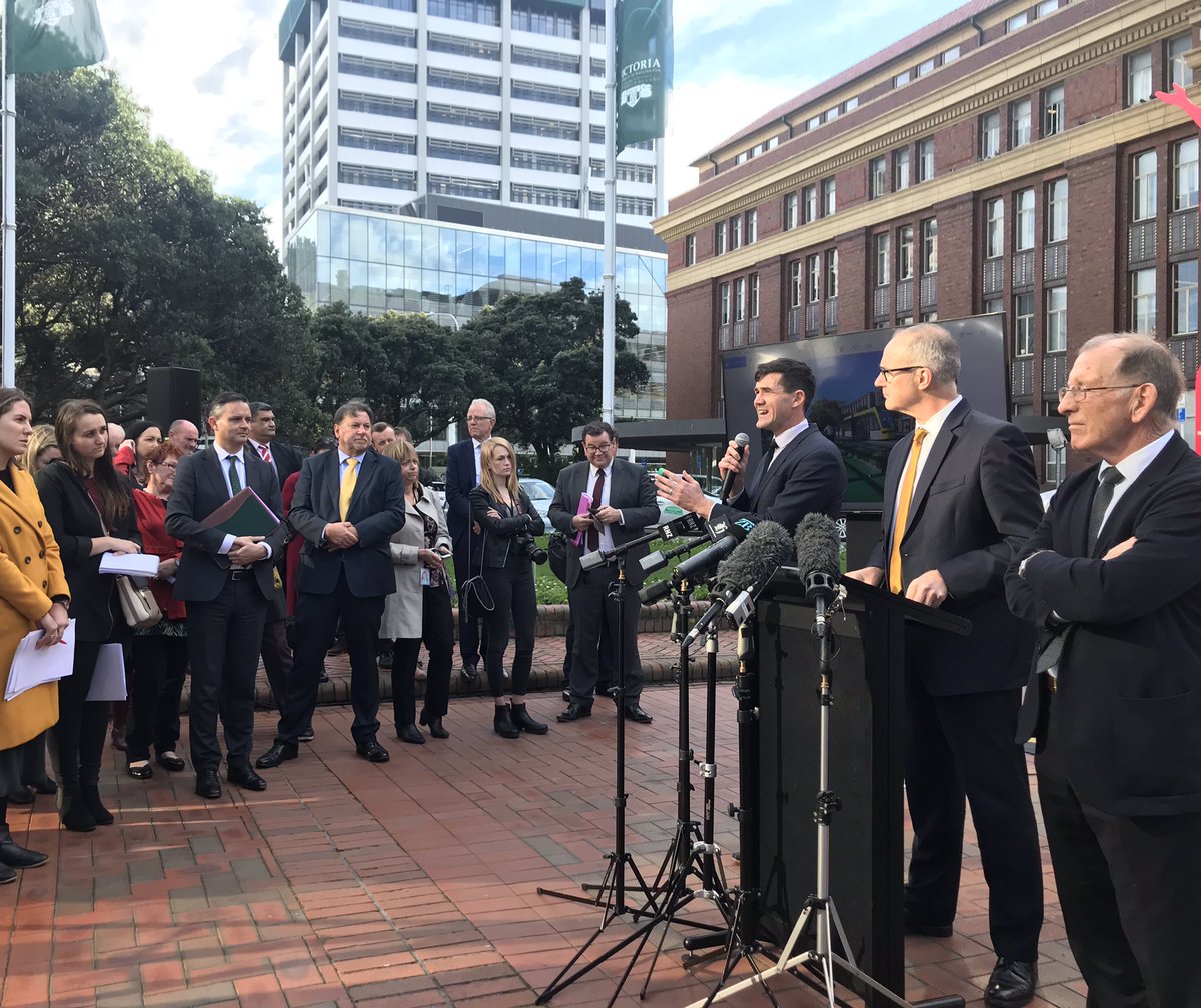
So today was the big day – the day that many of us have been waiting a very long time for. Of course, they must have lost my invite in the mail, as I wasn’t invited to the launch party, but at 10am on Thursday the unveiling started. Politicos and councillors and others gathered next to Ghandi at the Railway Station, unveiling hope for a better world. Have we got what we wanted? What did we end up getting?
Well, curiously, despite after waiting for around 5 years, we’ve still got no detail, just some context. We’ve still got no route. We’ve still got no idea what sort of system it might be, what is planned, where it will go, when it will happen, who will run it, why it was chosen etc. So: a number of questions. But it is not just pie in the sky wish list – there are some very detailed render drawing “hints” and these have obviously had an experienced company produce designs and renderings. So this means that this is not just a curious image picked up along the way, but instead a carefully crafted media presentation.
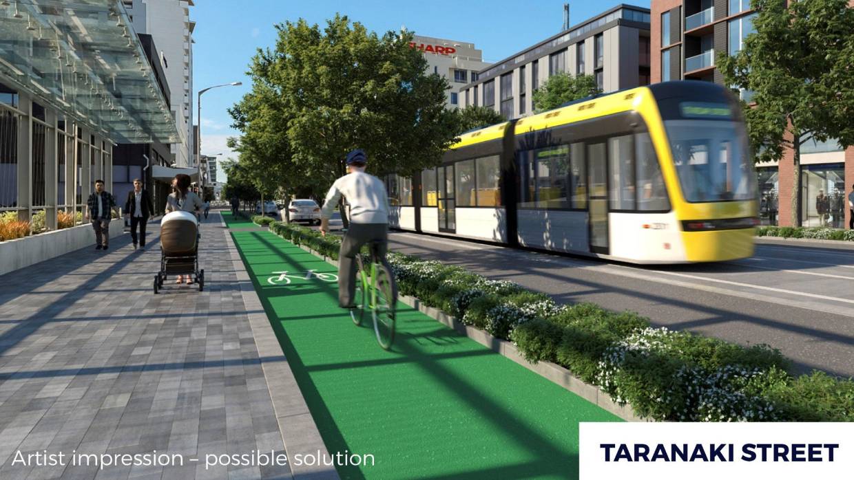
I’ll not go on about as to what is on offer – details will hopefully be come clearer over time. But let’s see what we can glean from the details at the moment. Starting with the image above – on Taranaki St, just outside Briscoes. Notice anything interesting about this image? Well yes, there is a protected cycle way protected by a nice little raised flower bed. It’s also obvious that despite being set 10 years in the future, Briscoes have still not managed to get anything in their planter boxes to grow higher than about 6 inches (what’s the bet that their consent application showed a verdant wall of greenery climbing up those wires?).
While what we are (i suspect) being asked to look at the yellow vehicle in the middle of the road (is it a tram? a train? a Light Rail vehicle? or a trackless tram that no-one has ever seen before?). I can see no tracks, other than some white lines on the road. Hmm, a mystery vehicle indeed, but the route is good. Light Rail or Clever Buses up Taranaki Street? Interesting indeed… But I confess that my attention is drawn to the five storey apartment building behind it, currently home to a Mazda / Ford showroom, and currently proposed to being a series of two level townhouses. Not Paddington Sydney, more Paddington London. Are we sure that the planned Paddington noddy houses have actually got planning permission yet?
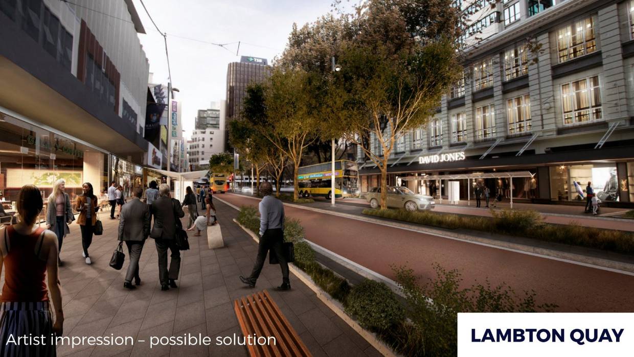
In Lambton Quay, things are a little different. No cycle lanes, in fact: no bicycles at all. Also – no trams, but instead buses coming and going. There’s a RangeRover parked outside the David Jones building, which is either a reassuring statement that Life (and shopping) still go on. That all makes sense too – Lambton Quay really is the country’s best pedestrian shopping destination, with no chance of being run over by cars. I like this one too.
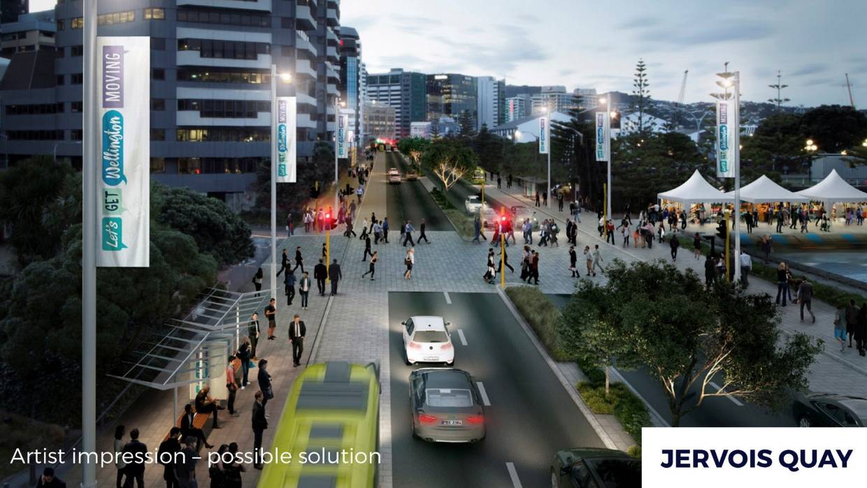
So it is Jervois Quay then where we really see some action. The trees down the median strip have grown, Frank Kitts Park still does not appear to have sprouted a Chinese Garden, and is that Illott Green still without a Music School building on it? But it is the traffic that we are meant to be looking at of course, with a dedicated bus lane each side (or is that a carefully blurred trackless tram instead?), and just two lanes of cars in each direction. At present it is three lanes of cars – so they are anticipating a slight reduction in numbers there. And of course, a massively wide pedestrian crossing, with loads of people happily crossing over to what looks like a festival of tents on the other side. Can’t disagree with that either.
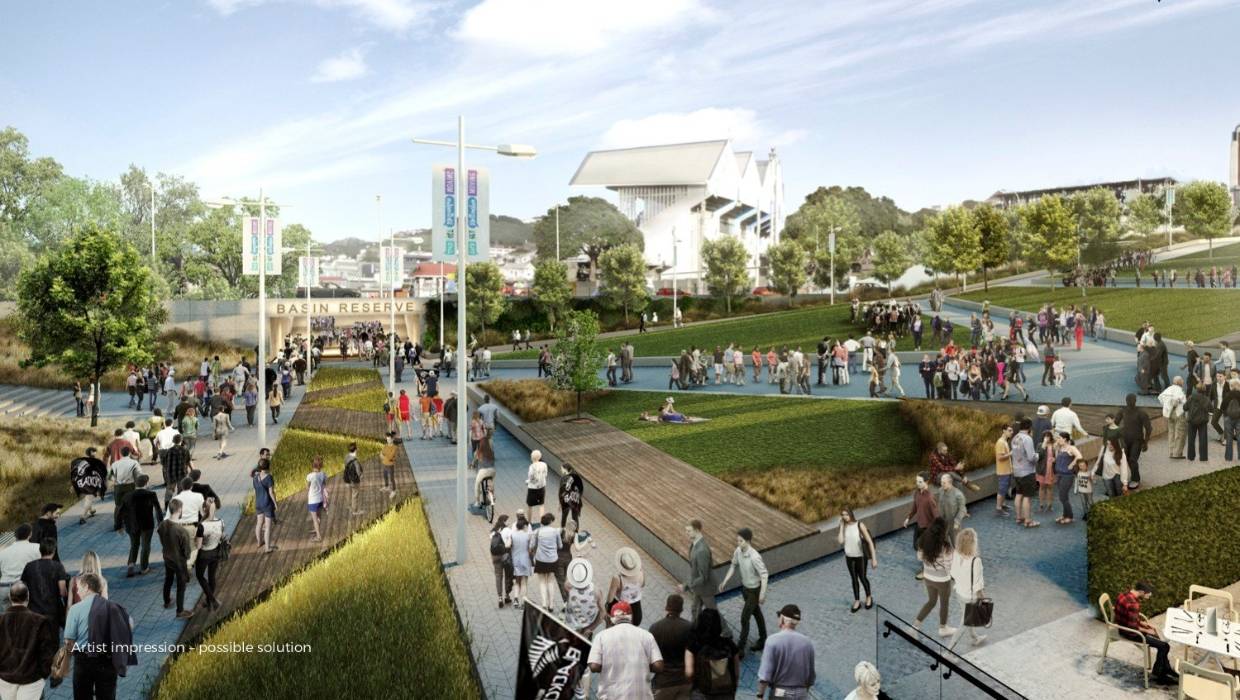
So far, so good. But what about the crunch points, the bane of everyone’s lives: the Basin Reserve. Well, although there are no definite plans showing the solution, again we have a well-resolved visual by our mystery illustrators showing a massively popular day at the Basin, with literally hundreds and hundreds of people flowing effortlessly into the Basin through a new Pedestrian-only ground-level walkway. No flyover – tick. Nobody sunbathing under the flyover either – tick – although there is a young woman having a picnic on the grass while everyone else walks past. Judging by the attire, with at least three people garbed in All Blacks attire, in the future we will be playing rugby at the Basin.
Where has all the traffic gone? Well, just over the entry ‘gate’ we can see part of the answer: cars are driving west, working with the slope of the hill, up towards the Arras Tunnel. That’s what this blog has been arguing for for years: work with the natural slope of the hill, then there is no need for a massive 250m long concrete flyover. I’m hoping that this means that the LGWM group have adopted most of the Option X solution proposed by the Architectural Centre, which did exactly this with the traffic and then proposed a big green connection from Pukeahu Park to the Basin. I’m still not sure where the Adelaide Road traffic has gone to – presumably underground somewhere near here? Let’s look at that from another perspective:
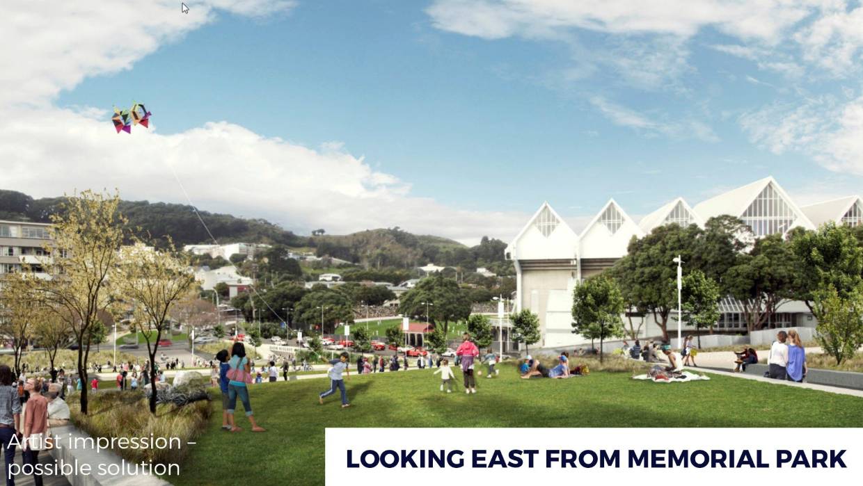
Here we can see that the traffic is indeed flowing two-way on the new route – good work. The Save the Basin group has raised its hackles a little, growling that this looks like another attempt at a flyover, but this is anything but that: it is a logical traffic solution that can be integrated into the local surroundings and will avoid the massive flyover solution from before. It is so popular with the locals that we can even see small girls flying kites, although perhaps here is a bit of artistic license: from the wind direction it seems to be a Southerly, and after the weather yesterday, I’m really not sure that anyone would want to fly a kite in one of those gales…
Overall then, I’m really pleased with the picture that has been painted. We’ve had the big launch day, at long over-due last, and now the politicians and the Treasury can argue over the costs and the details. Apparently it will take two years to even get the relevant Bills passed through Parliament, which seems agonisingly slow, but that does actually give us a chance to get those details sorted out. There may or may not be a second tunnel under Mt Victoria, and I really don’t mind if there is, as the current tunnel is an appalling route for pedestrian and cycle. Apparently a second Terrace Tunnel has been ruled out already, but directional middle lane may be coming instead: makes sense I guess. There is a massive price tag on all this of course: $6.4 billion, give or take, and exactly how we pay for it is still being argued over. But I don’t care how: I’m just hoping that indeed, with this big step forward, that we can indeed really and truly, Get Welly Moving again.

I see on the Jervois Quay render, the pedestrian overbridge has mysteriously disappeared? Interesting…
As long as they can get funding into law quickly so someone can’t mess it up in the future (I notice that two years is after the next general election, in fact)… I suppose 2029 is only ten years away, but given how much of a pain getting to this stage was I wouldn’t be surprised if that was pushed back too. We can only hope that the minority of people who think more and wider roads are an important part of any solution do not get involved and water down some of these proposals (especially Taranaki St, which is a disgrace at the moment).
A couple of thoughts: there’s no mention of what’s going to happen north of the Railway Stn (i.e. along Hutt Rd and Aotea Qy) – there must be something going to happen up here, as it’s both one of the main entry points into the city and the place where the Hutt-Wgtn cycleway will end up. (I do recall that WCC had a consultation about this last year, actually.)
There’s also nothing (unless I didn’t see it) about the part of the Golden Mile south of Lambton Quay – I suppose most of that is WCC’s problem not NZTA’s, though, so it makes sense it’s not there. (But why put in Lambton Quay then?)
Also I note that the Inner City Bypass won’t be dualled until “after 2029”, so that means the improvements to the basin (and hence the new green space where the north end of Cambridge Tce is currently) won’t be happening for ten years.
So overall a very good vision, but stretched out over time frame that’s a little too long to be reassuring. I think the main benefit of this announcement is that it will allow GWRC and WCC to unlock the funding that they’d put aside for “LGWM projects”, and hopefully from that we’ll see a concrete(!) benefit in the short term.
Oh RE the ped footbridge, that render looks like it’s sited on top of the current City to Sea bridge looking north, so I guess the one you’re talking about is the old white one?
I thought Council had been trying to get rid of that for ages anyway… a good pedestrian at-grade crossing like that is far better, as long as the city-to-sea bridge is either retained or replaced in addition to it (not so much to provide safety from fast cars – which should be dealt with either way – as to retain an important tourist spot, the only semi-elevated view in the CBD across to the Remutakas).
My take on it is we will get guided bendy buses but they cant admit that yet for some reason. Unless there is a change of government in which case we will get four lanes to the planes for Brent Hudson and his BMW customers instead.
> it will allow GWRC and WCC to unlock the funding that they’d put aside for “LGWM projectsâ€,
I think you will be disappointed, the city and regional council have allocated very little in anticipation of LGWM, and they are being expected to find $2.5 billion….
To be honest the $6 billion headline is a con
Its actually a $600 million PT package ( cycling/walking/pt improvement) with $1 billion for the Basin improvements, the 2nd Mt Vic tunnel and the expansion of Wellington Rd/Ruahine St).- but these are not scheduled till after 2024
Then there is the light rail/mass transit priced at $2.2 billion (+$2 billion in interest – that the city and regional council payoff @3% over 50 years)…
I think that’s Blackcaps, rather than All Blacks, attire.
How could you possibly get your black-and-silver-fern ensembles mixed up…..
KLK – Black Caps, All Blacks, Tall Blacks, Black Cocks, Black Sox, Ball Cocks – really? I honestly don’t know what is what. But yes, if you are indeed right, it makes a lot more sense – going to see the cricket.
Mason – thanks for your comment, and I really hope you are wrong! Bendy buses are just dumb…. I was in London when they were introduced and promptly got stuck on all the roads and intersections = a hopeless technology for a city that is not planned for it. Not a quality solution for Wellington. But I am a little perturbed by your comment on Brent Hudson and BMW, which I see you have also posted to the Greater Auckland website as well. Who is Brent Hudson? When I google his name, I get told that he is the Station Officer at NZ Fire Service, which is nice, but possibly not the right person. Or he is someone in a TargaNZ race? Or, perhaps, he is a National Party List MP based in Ohariu Valley, in which case he is, in my books, a complete nobody.
I think you can also read a lot into people’s body language. Have another look at that top photo. Men in dark blue suits: women mostly relegated to the 2nd or 3rd rows.
Justin has his hand out, looking like a 1950s shop mannequin as usual, but he is reaching out to people, trying to establish contact. Phil Twyford is ready for action, legs wide apart, braced for the impact he wants to make, despite treasury telling him “not yet!” Other man in a yellow tie in the audience – he’s ready to go, possibly in this direction, but equally possibly in the opposite direction. Jimmy Shaw has his books at the ready, carefully listening, a minister outside cabinet, so to speak. A funk camera-woman, mostly boots and legs. She’s not happy – no great photo op here. The tall haughty bloke behind her, looking the opposite way – he thinks he is better than us, and doesn’t even need to listen. Paul Eagle is eying him up, warily. Our two female reporters at left don’t appear to have written anything yet – listening, quizzically.
Grant Robertson, my favourite MP for Wellington Central, is poised ready for action. Is that a wallet he has, half open and ready to start dishing out cash? Or is he just answering a text from me? Whatever: he is smiling, which I’m taking as a good sign.
And then there is the sour lemon in the room: Chris Laidlaw, arms folded defensively across his chest. That’s the classic pose of somebody who is not listening and not prepared to change their opinion. Never mind – with a bit of gentle pushing, he will fall on his sword before the next elections and disappear for all time from sight. Hopeless old dinosaur without a clue what he is up to.
“The tall haughty bloke behind her, looking the opposite way – he thinks he is better than us, and doesn’t even need to listen.”
I don’t know if you’re being sardonic or not, but that is Greg O’Connor – current MP for ÅŒhÄriu, and former President of the New Zealand Police Association for 21 years.
Sea Monkey – no, wasn’t being sardonic – genuinely didn’t know who he is, although I know his face from somewhere. I think I got it summed up in one therefore:
“Greg O’Connor – current MP for ÅŒhÄriu, and former President of the New Zealand Police Association for 21 years, thinks he is better than us, and doesn’t even need to listen.”
On another note, can someone please show the render of Taranaki Street to the developers of the Paddington development and suggest that even these mock-up, gap-filler buildings put in as an afterthought to make the render more interesting are better than what they’ve come up with in their development?
Also re turning Lambton Quay and Willis Streets into bus only and selling it as a vast improvement. The only cars that seem to use Lambton Quay at the moment are couriers and taxis, so I can’t see it being that much of a change.
@Tom. Closing Lambton quay to private cars isn’t really a problem, there are plenty of ways around it….
Willis street is a bit trickier, the section between Manners and Lambton quay is the one of few north traveling streets , if it was closed, traffic from Brooklyn etc would have to either use the Terrace, or Taranaki street, to get to the other end of town…
I note, on the Lambton Quay picture, the double decker is also … double axles, which means it’s still running on fat diesel. In 2036. So much for GWRC promising an electric future in 2018.
Benny – yes, I hadn’t picked that up, but I think you’re reading too much into that. One word for you: Photoshop.
GWRC may well be incompetent, but the person doing the rendering is only human, and they have snaffled a picture from 2018 to produce the picture purporting to be 2036.
was under the impression the national MP Brent Hudson was somehow involved with the BMW dealer in Kaiwharrawharra.
The biggest surprise to me is the light rail on Taranaki Street rather than Kent/Cambridge Tce.
I’m trying to picture the route from Railway Station to the Airport. Jervois Quay vs. Golden Mile. Both options have merit.
But Taranaki St surprises me. Where from there. Wallace St or Arras Tunnel? I prefer Jervois, Cable, Kent, Adelaide.
Maybe Taranaki and Wallace avoid having to address both trams and cars at the Basin.
Then I assume Adelaide Rd or Wallace St to the Hospital. From there is it a tunnel to Wellington Rd.This could be for trams, cyclists, pedestrians and west bound cars. Otherwise continue up Riddiford and Mansfield Sts to the Zoo and a tunnel to Coutts Street in Kilbirnie. Again both options have merits but via the zoo really appeals. A third option is to travel over the hill via Constable St and Crawford Rd to Kilbirnie.
Should the tram get into Kilbirnie, rather than bypass it on Cobham Drive, it could then travel along Coutts St to the airport under the runway. But another image (not shown by EotF) shows a tram on Cobham Drive at the north end of the runway. Whilst this route from Coutts St is not impossible it is more likely to be be from Rongotai Rd or St Pats. Therefore its unlikely light rail will go up to the zoo or pass through Kilbirnie. Thats a pity.
So what is the likely route?
Stuart you might like to have a look here: https://fitwellington.org/news/2019/1/30/questions-about-the-proposed-route-answered and here: https://fitwellington.org/news/2019/5/5/how-fits-proposed-light-rail-route-has-evolved to see a possible route concept layout and the reasons for it
Stuart – thanks for this lengthy and thoughtful post – really appreciated that you show up and comment!
I do wonder if some of these images are put in there just for provocation, rather than because they have been properly thought through. I didn’t put the Cobham Drive pic in this post because I think it is a red herring – I honestly think that would never happen. Far more likely for the route to go through Kilbirnie and Rongotai – perhaps down Coutts St or Endeavour St, and under the runway, rather than to try and squeak around the roundabout at the north end. That would just be madness.
Jervois, Cable Kent and Adelaide means you have to face the action at the Basin – which is just too much grief. Leave that to the cars. I’d go Taranaki and then underground at the High School if I held the pursestrings….
How about turning Tory into an Amsterdam-style pedestrian/cycle/tram shareway from Cable to the Basin?
Starkive – not a bad idea, but I had always thought that Taranaki has room for 2 lanes to be taken permanently out of commission from Cars, and turned into LR route – while Tory should have all cars taken not, and made to cater for just Pedestrians and Cyclists and lots and lots of restaurants. How does that sound to you?
thanks for the info Sam. I’m really impressed with the work you and FIT have done.
I’m very happy to see the logic of the route with one exception. Certainly Taranaki St makes sense if a tunnel under Mt Cook connects easily to Adelaide Road.
The exception is Miramar before the Airport. Passengers going to the airport will not thank you for that diversion.
Watch this space Stuart. I’m working on something that could answer a few queries that people have…
Here’s an interesting headline from the DomPost:
https://www.stuff.co.nz/national/113301410/cars-removed-from-golden-mile-within-two-years-as-part-of-lets-get-wellington-moving
“Wellington’s Golden Mile could be car free by 2021, and speed limits on surrounding streets dropped to 30kmh. Changes to city speed limits and the number of roads which have private vehicle access have been proposed in the $6.4 billion Let’s Get Wellington Moving programme announced last month.
While the plans do not go into specifics, Wellington Mayor Justin Lester said that would mean 30kmh speed limits for all roads except main arterial routes, and the removal of private cars on most, if not all, of the city’s Golden Mile.
The roads would still be accessible to service vehicles, but would otherwise be used only by buses and pedestrians, Lester said. There were also plans to “claim back some of the street” along the thoroughfare, meaning shops and eateries could spill out onto the road.”