
Like you, I’ve been sitting down reading all the millions of pages of information provided by LGWM in their first major release of proposals for Wellington. They’ve just been talking about the Golden Mile so far, and they have narrowed the thinking down from 256 options down to 21 options and then later to just three simple variants (Do Nothing is not an option).
Option 1 – Reduce Traffic
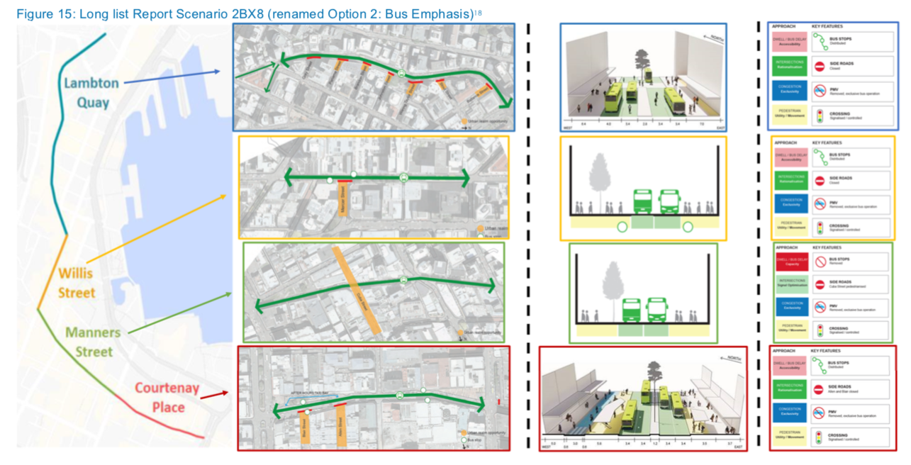
Option 2 – Bus emphasis
Option 3 – Bus + Pedestrian emphasis
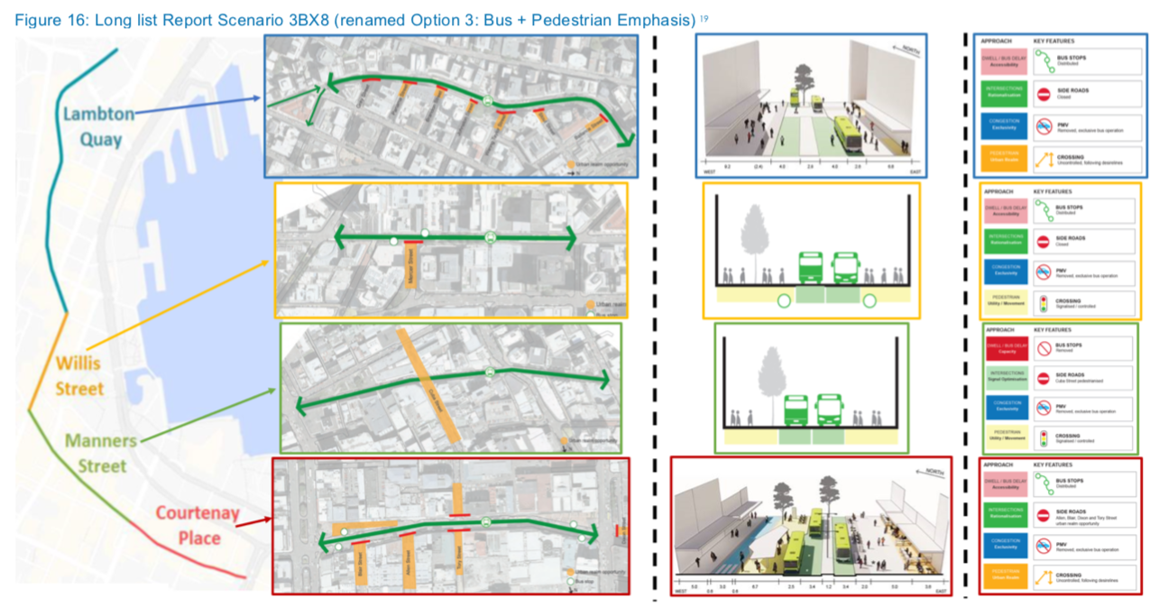
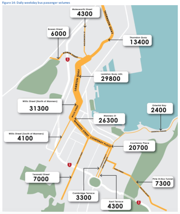
They’ve then broken the route down into 4 different segments – ie Lambton Quay, Willis Street, Manners Street, and finally Courtenay Place. What is important to note tis that it may be possible to “mix and match” ie take Option 1 for one part, option 2 for another and option 3 for yet another part, although I think that may have horrible consequences if we do. Although we are being presented with just three options (in an effort to make this simple and understandable by the general populace), in reality we still have many options. Here is one of their graphs showing one of the key drivers for all this: large volumes of buses and passengers up and down the Golden Mile.
Unlike the Basin Bridge fiasco, where the only two options presented to the public were A) a silly flyover and B) a silly flyover with a sillier route, at least in this scenario there has been some really good hard work in looking at all the options. It’s interesting – the team involved has some similarities, with Selwyn Blackmore being once again present for NZTA, but with a new team of consultants that is almost completely different. Calling themselves Futuregroup, the Opus presence from the Basin Bridge has now rebranded and is now WSP, while the others have been more wholly changed: Athfield Architects is gone and replaced by Jasmax; Wraight Associates has gone and is replaced by Boffa Miskell and new boys on the block Local; and whoever the engineers were before – now its Aurecon (formerly a local engineering practice, now part of a global giant consulting practice). There’s also the interesting addition of MR Cagney into the mix, who have also previously provided much of the grunt behind Greater Auckland, and that gives me hope that the schemes will indeed be nuanced better towards the public. There’s also EY and Stantec in there – EY used to be accountants, but with their new branding who knows what they are now. Number crunchers or branding experts, or perhaps they just make good coffee. Stantec are also formerly a local engineering practice, now part of a global giant consulting practice – in this case having swallowed up Traffic Design Group, so I presume that they will be doing the traffic calculations, arguably the most important task of this project.

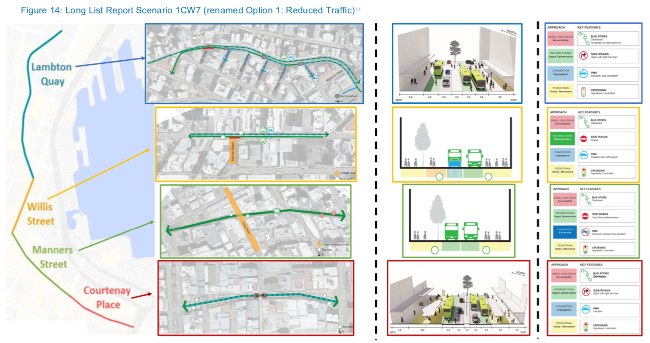
Of course the best thing for you to do would be to go off and read all the bumpf the same as I have, but honestly, it is exhausting and boring, and so I’m going to present you with some of the options. Let’s look at Lambton Quay first. Here’s their first option:
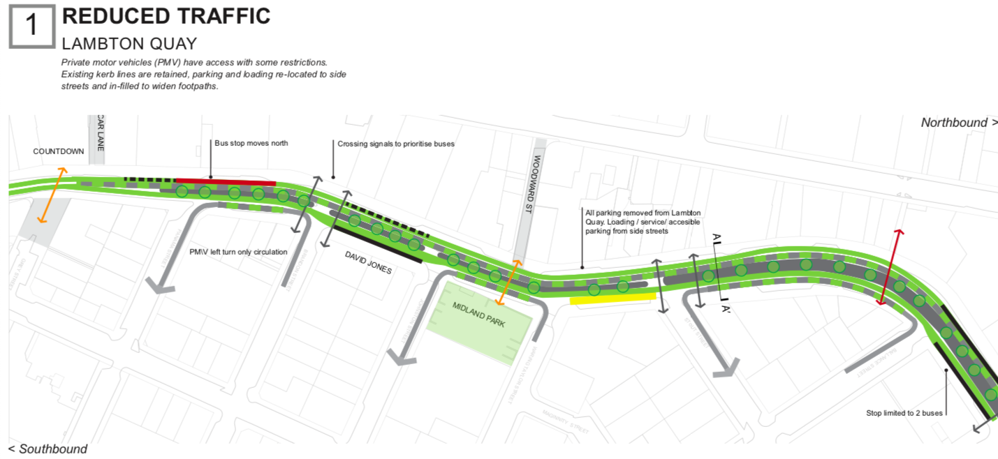
So, Option 1 at Lambton Quay lets some cars (Private Motor Vehicles / PMV) through, but parking on Lambton is removed to the side streets. Cars can travel on Lambton for certain blocks going South, but only for a block and then your car would be cast out again. There is a full length lane driving north for cars, so overall, not much change from at present to my eyes, and therefore not really worth doing. Let’s make a decent change while we’re here.
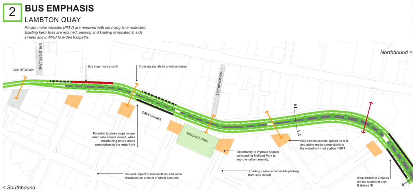
Option 2 on Lambton Quay shows that instead of the cars travelling South on Lambton, they are simply stopped altogether from entering from the side streets. Presumably there would have to be an area created for cars to turn around at the end of each newly created cut-de-sac at the sort of orangey coloured patches on the map above. There are two lanes for buses going each direction – so it is best for buses but not so good for pedestrians. This gets a big tick for improving bus speeds and is probably the one that the LGWM team are going to be pushing for.
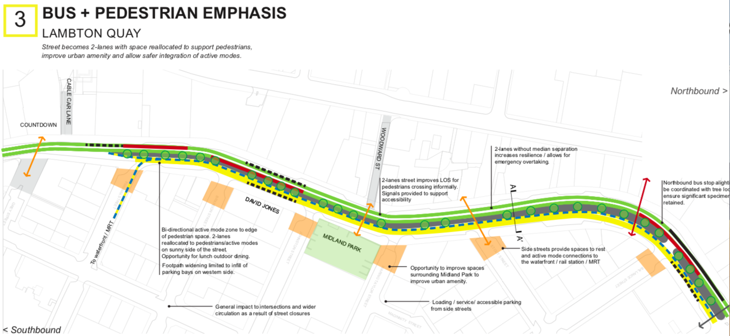
Option 3 on Lambton Quay aims to provide both speedier buses and speedier pedestrians, by keeping both the bus lanes on the West side of the street, and drastically enlarging the east side pedestrian area as well. There is just one bus lane each direction, instead of the two lanes offered in Option 2. This is of course a lot more expensive, as new paving etc all costs money. But hey, if you’re saying let’s go for the theme that offers the best experience for the city, then this has to be the one.
There’s another thing to this which is not really touched on much in this – and that is the integration with the masterplan for the whole city (thanks GreenWelly) which I’ll touch on in another post, and also things like a master cycle network, of which, amazingly, they publish in this study by-the-by, as if it is of no consequence. Have you ever seen this before? No, me neither…..
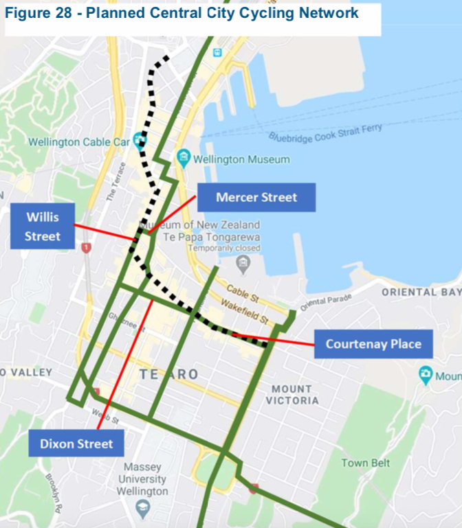
There are some important things to note from the Cycle Network diagram (fig 28 above) – that the main cycle route north would be up/down Featherston St, and mostly up Willis and down Victoria St, leaving a lot of Willis St to buses only. Looking at the other end of the Golden Mile, down at Courtenay Place, there are again the 3 options, and with some variations. Taranaki Street also gets a green line, as does Kent/Cambridge, but curiously, not Tory Street. This is really odd to me – it seems so obvious to me that Tory Street is the best Cycle route for everyone. But I think we can probably agree that at this stage, fig 28 is at best, unresolved.
Okay, I’ll leave you today with their simple 3 options about Courtenay Place.
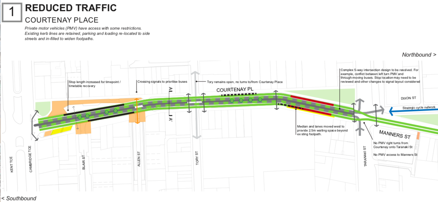
Option 1 on Courtenay: Cars are stopped from driving onto Courtenay from Blair and Allen, the east-end slip lane is closed off to traffic, but otherwise there is still the continuance of cars crossing over at Tory and Taranaki. Remember that the long term plan is for Mass Transit to be coming up Taranaki, so there will always be a big intersection there. Look at the state of that intersection – that’s a clusterfuck if I ever saw one… There is also a sharing of both buses and cars coming up Courtenay in both directions.
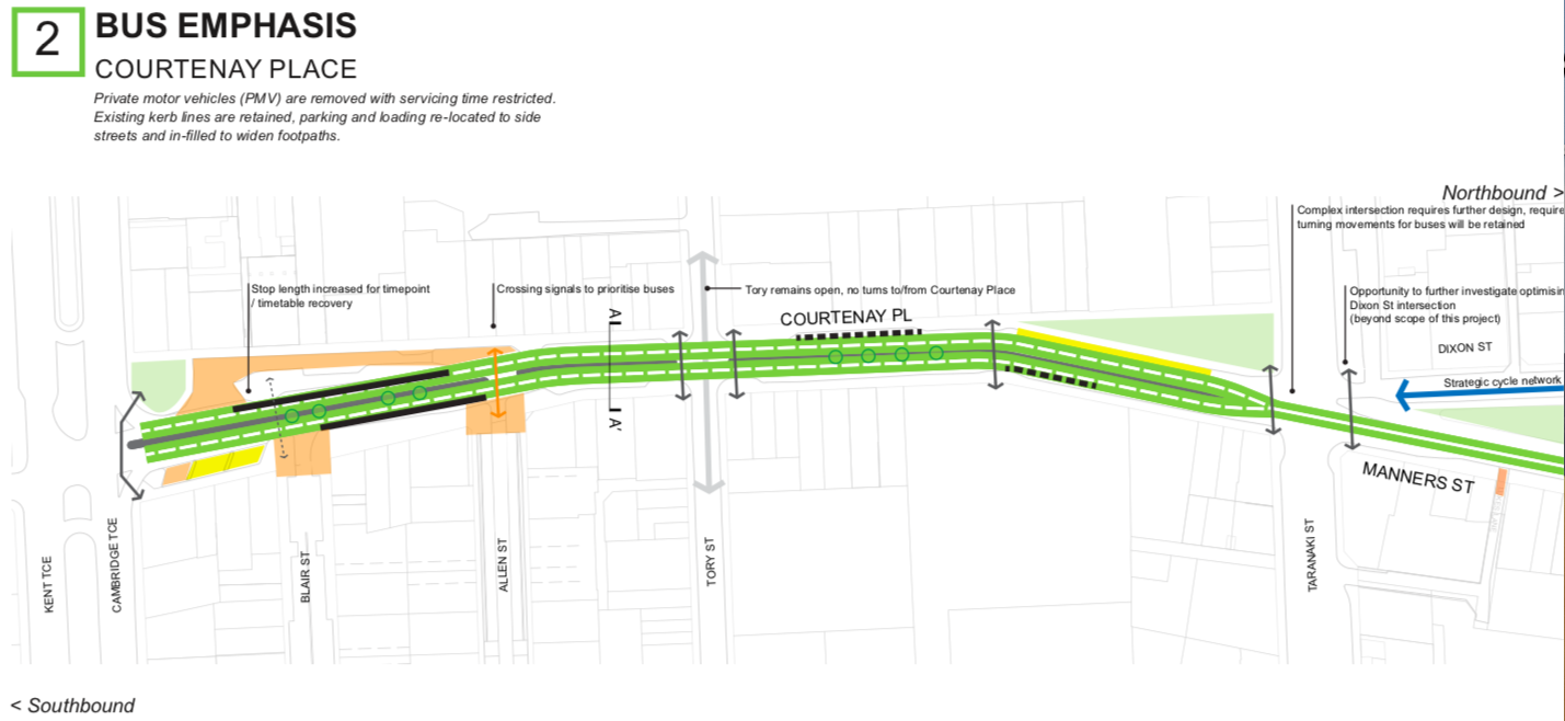
Option 2 on Courtenay: Two lanes of bus lanes up and down each side of Courtenay, still allowing car traffic to cross over on Tory, but a lot simpler at Taranaki Street.
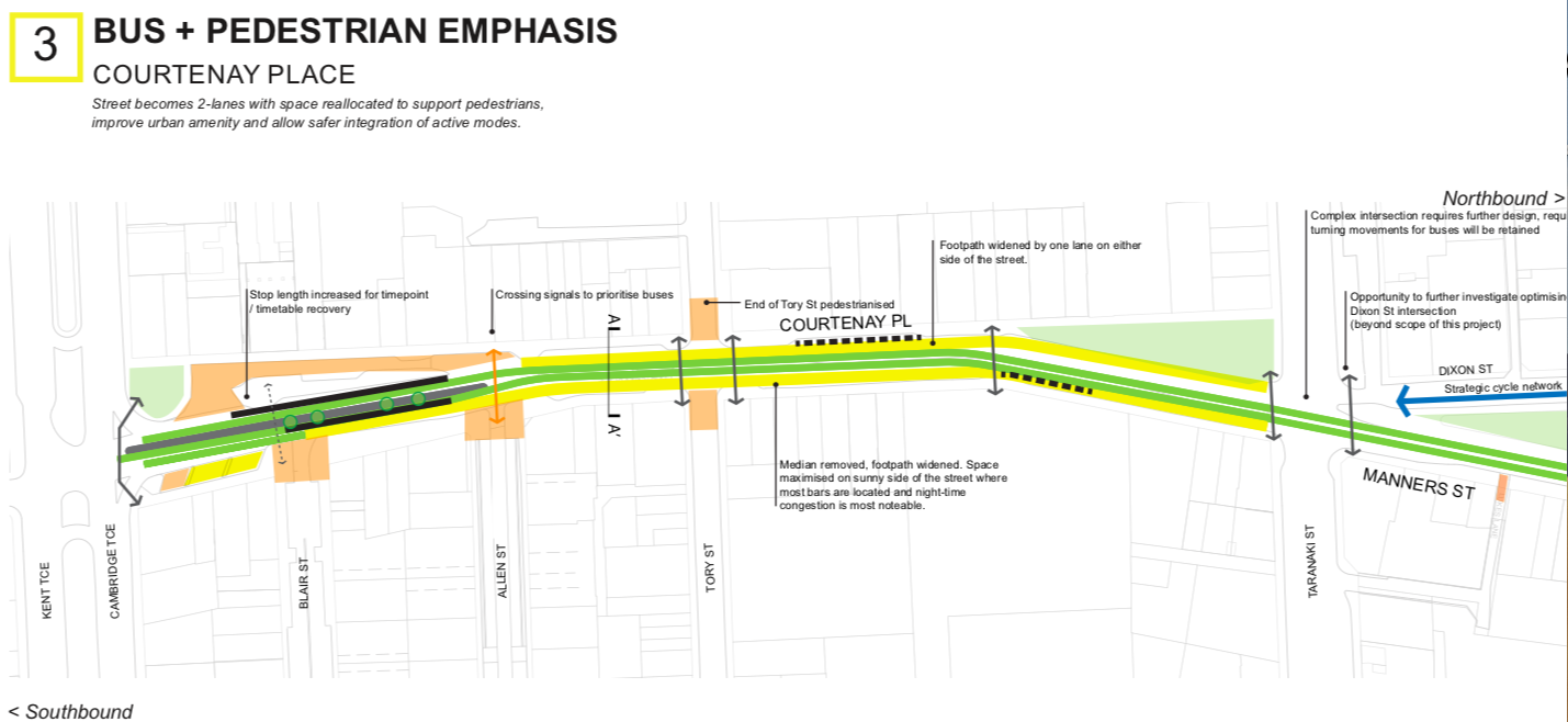
Option 3 on Courtenay: Like the Option 3 at the other end of the Golden Mile, there is just a single bus lane up each side of Courtenay, and considerably widened footpaths. Traffic is stopped crossing over on Tory Street, as well as Allen and Blair. Interestingly there are a couple of sub-options here, noted as 3a and 3b. To do with Cycling.
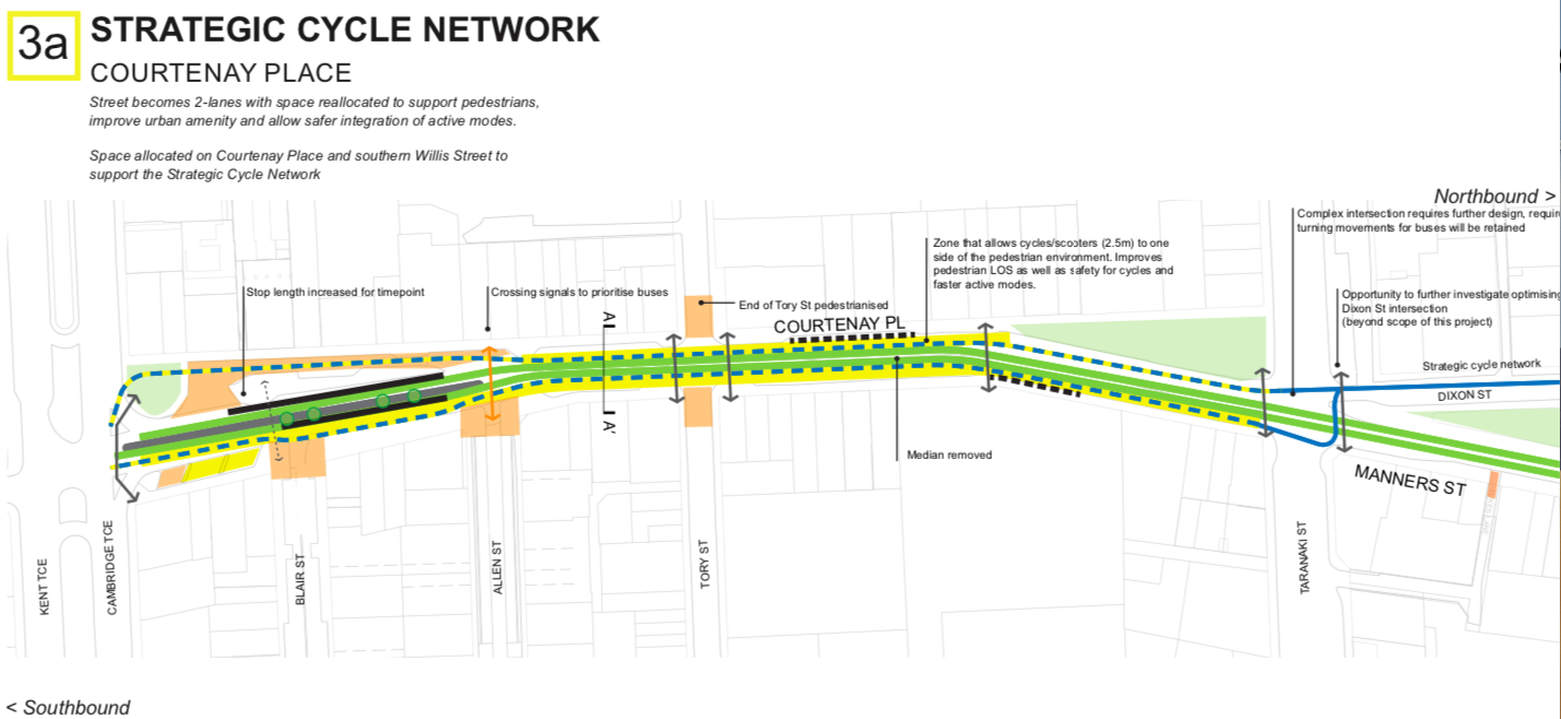
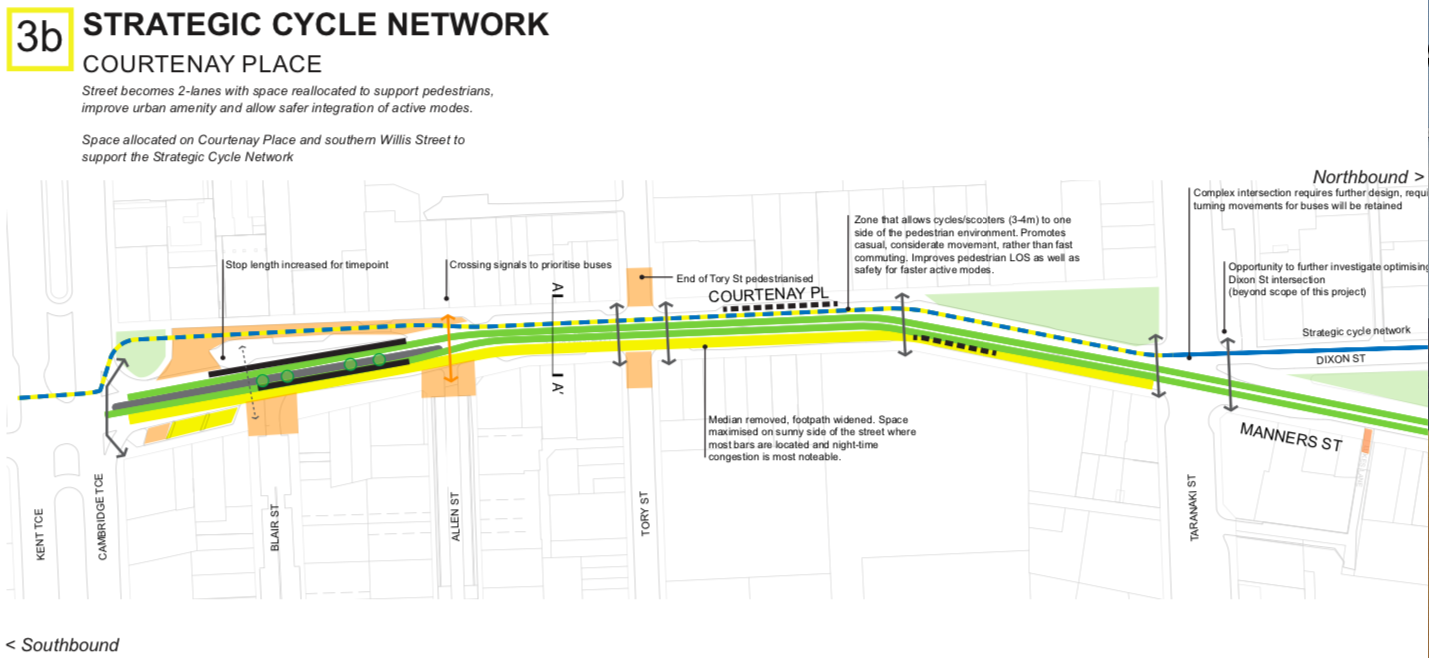
You can notice from 3a that there is a cycle path each way on Courtenay – on either side of the road. But in 3b, there is just the one cycleway, on the south side of Courtenay. That clearly works a lot better at the junction of Taranaki and Dixon.
I’ll tackle the two middle sections of the Golden Mile another day, but they are simpler, as there is not as much room to wiggle around due to width constrictions. So, now that you’ve seen them all, what are your thoughts?
My first thought – on which planet do the writers of the report live when they state in the picture 3b above that:
“Median removed, footpath widened. Space maximised on sunny side of the street where most bars are located and night-time congestion is most noticeable”
How is the north side of the street the sunny side? Its a minor point I agree, but surely the south side of Courtenay Place is always going to be the more sunny side of the street?
Thanks Alan – a minor point, yes, but also a good point. In my humble opinion, Wellington is hard done by for pubs and bars where you can sit and drink in the sunshine – a most important factor for pleasant drinking. I guess that it is because of the angle of Courtenay Place and the low angle of summer sun, but the northern side of the street is definitely sunnier in the afternoon in summer. Many a time I’ve sat down at the corner outside Downstage and enjoyed a beer. Not lately though. It’s certainly good to see that they’re proposing to fill in the car parking there to provide more outside drinking space – no complaints from me there!
Great to see some real work being done here, but the fact the Courtenay Place map has been drawn with north at the bottom does not fill me with confidence.
>Option 2 on Lambton Quay …This gets a big tick for improving bus speeds and is probably the one that the LGWM team are going to be pushing for.
Yip, the entire report is written to conclude this, standard Operating procedure for consultants and officials is give 3 options 1) do least , 2) the one you want. 3) the Golden enchilada- with correspondingly golden price tag..
On Page 45 of the short list document, we get this
“Options 1 and 2 are expected to be within the indicative LGWM project budget of $40M, and
Option 3 is expected to cost approximately twice that of Option 2 and is therefore expected to exceed the indicative LGWM project budget of $40M.”
https://lgwm.nz/assets/Documents/Technical-Documents/Golden-Mile/Golden-Mile-Short-List-Report-June-2020.pdf
Option 3 is costed at $55-80 million and with the whole COVID thing, I suspect the chances of Council pushing the boat out on this (with the extra costs sitting solely with the council alone) is very very unlikely…
greenwelly – that’s a cynical viewpoint, which means you’re probably 100% right. But my viewpoint is that we should aim for what is best. If Option 2 is the best, then we should advocate for that. If Option 3 is the best, then we will need to fight for that. Are you with me?
Option 3 is IMHO the best, but it is still limited by the fact there are too many buses on the golden mile,
Having only one bus lane in each direction sounds great, but in reality it ends up like manners street, if there is a breakdown or congestion from a motorway crash etc, etc, the whole thing turns into a conga-line of gridlock….
Also by preventing general traffic using parts of the Golden mile (willis)_ and limiting the ability to “cross the streams” its going to drive a lot of cars onto Taranaki St and the Quays (which if I’m not mistaken are supposed to be where the LRT is going to be)…
Making Karo drive bi directional and getting SH1 out of Vivian street could help with this, but LGWM arn’t allowed to look at that
Whaddya mean they aren’t allowed to look at that? Surely that is going to be one of the key things on their list? Nothing is crossed off as far as I know – but then again, I don’t know that much. What do you know GreenWelly ?
I think you’re right though about the possibility of any almighty great clusterfuck at the junctions with Taranaki St. I was going to look at that in another post….
The indicative package (the one approved by Cabinet) has no component covering SH1 from the Terrace tunnel to the basin, The only sections included are the Basin reserve + potential 2nd tunnel and Ruahine st widening…
https://www.transport.govt.nz/land/lgwm/
The Te Aro section got taken out because the most acceptable option is tunnelling it, but that is too expensive. and if it got left in you would see a push to ditch other bits to fund the tunnel
I think eventually they will have to reconsider doing something to Karo drive and Vivian street. but its certainly not going to be part of the work programme in the next few years….
Sigh…. this is all so simple and easy and doable, it is so frustrating that no one gets it. I don’t mean you Greenwelly – I do mean those in power (I’m assuming that you are not a high up member of the government – from your name, you could be a Green Party candidate / member for Wellington. Perhaps you are actually James Shaw? Or Julie Anne Genter?)
There’s no need for a Basin Bridge or for tunnelling at the Basin. The job is half done already – and the visuals put out so far by LGWM back this up – SH1 running west and then north will travel at ground level around the north face of the Basin, and then go up behind the grandstand and connect with the Arras tunnel. Its a relatively simple thing. The only new bit will be a new section of Sussex Street which will bridge up over the top of the SH1.
The SH1 route south and east will continue down Vivian St for the foreseeable future as you say.
https://www.stuff.co.nz/national/122047984/wellington-business-owners-worried-golden-mile-plans-will-be-disastrous-for-retailers
A backlash is brewing over proposed changes to Wellington’s Golden Mile, with local retailers saying the plans are “disastrous†and “send shivers down my spineâ€. The plans were announced two weeks ago as part of the $6.4 billion Let’s Get Wellington Moving (LGWM) programme, and lean heavily towards removing private vehicles from the central city route. Two of the three options also propose closing off most side street access from the thoroughfare, with existing intersections possibly turned into pedestrian spaces instead.
But it is the suggestion of closing off side streets – and potentially removing parking from some of them – that is causing some local retailers to fret. Delivery vehicles could still be allowed on the Golden Mile at certain times of the day if private vehicles were removed. But failing that, side streets would need to be used. Cranfields owner Nicola Cranfield, whose store is on Johnston St off Lambton Quay, said the street would likely be too narrow for many delivery trucks to turn around in. She had been advised by her delivery company that many of its trucks would not be able to use the space.
“It’s a one-way street that will have to become a turning circle at the end. You would have to take quite a few car parks away to do that, and you wouldn’t get that flow of people driving past our business to see us. “I’m just a little surprised that these proposals have been released and all of them have a very significant negative impact on our businesses.â€
A premium would be charged if the delivery company could only use the Golden Mile at certain times, she said. Simillimum​ Health and Homeopathy owner Michael Dong, whose store is on Panama St off Lambton Quay, also had concerns about trucks turning there.
“I don’t know how they would do it. It’s not going to be ideal.â€
Removing private vehicles and parking from the Golden Mile (Courtenay Place, Manners St, Lambton Quay and part of Willis St) would also be a blow to the business, Dong said. We rely on people coming into town and picking things up. It will drive more and more people into that online space.†Kristina Raffaele owner Kristina Muollo, whose store is on Waring Taylor St, said removing car parks in the area would hurt nearby businesses.
“Wellington is windy and cold and people just want convenience. “A lot of us in the retail sector are concerned people are being driven out of the city. We need to encourage them back into the city.â€
People thinking small again… Delivery firms can have different sized trucks… and also, trucks can use reverse gear…. such problems are not beyond the abilities of humankind to solve.
Sigh, The Ancient Greeks and Romans had this device that allowed them to rotate the scenery behind the cast on stage,
I think we call it a Turntable, and Woodward street had one for years,
http://www.stuff.co.nz/dominion-post/news/local-papers/the-wellingtonian/9615565/A-street-with-a-stream-and-a-turntable
and Oh look here, they make these ones to allow trucks to turn around in tight spaces, https://www.truckturntables.co.nz/
Perhaps instead of “taking away quite a few car parks” they could put in one of these, even at a few 100K each they are not going to break the bank on a $80m project…
Perhaps the Woodward Street turntable is still in storage somewhere Alan. That would make life easier than 94-point turns
to be honest, and I’m being perfectly truthful here, there were two things that drew me to this city: the weather (I love wind) and the Woodward St turntable. Every time I cam here in a car I would drive up there just so I could pull the rope and get turned around. Such fun. A statue of a spinning top does not have the same effect on my 10 year old boy brain…