
So far, so good – in Wellington at least. The rest of the big Fish of Maui seems to be taking a pasting. Weather is easing and we may have escaped the really serious stuff, down here, but further north things are seriously concerning – and it is now rather obvious just how vulnerable to storms. I’m particularly concerned about places like Hawkes Bay, which is famously a place of sunshine, fruit, crops, green fields turning brown in the harsh sun, and of course its Art Deco architecture. But right now, it is the four main rivers that are really causing issues.
There are three rivers in a bunch – Tukituki, Ngaururoro, Tutaekuri, and then the Esk further north. Before the 1931 earthquake, much of that water came through the massive inland sea that then poured out at the Ahuriri harbour mouth – which all changed after the quake of course. But right now, nature is reverting to its former paths: the entire Hawkes Bay region is really still a river delta. A flood plain, if you will.
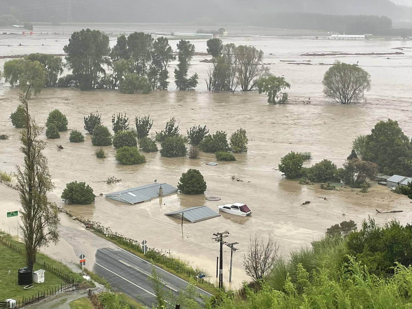
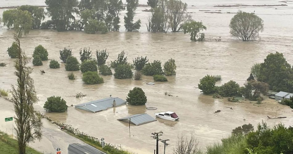
And who came up with the idea of building on a flood plain? If you do, this happens !
Brief halt for a day’s work, and some new plans below.
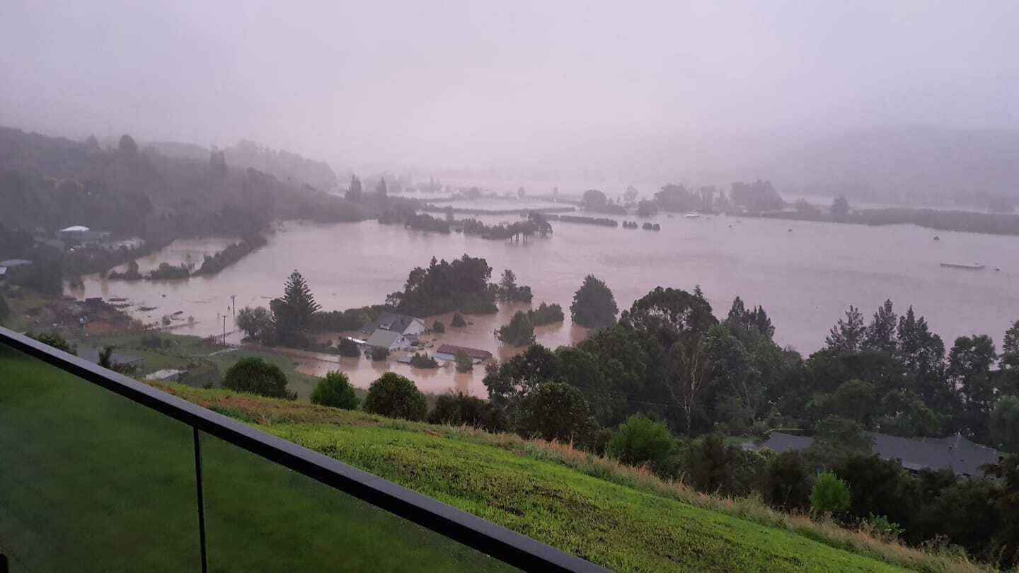
Here, zoomed right out, there is a larger view of Hawkes Bay showing the large rivers racing across the plains.
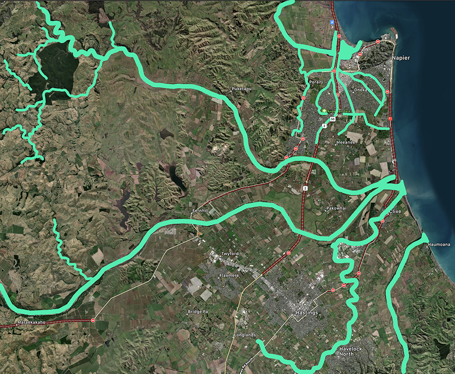
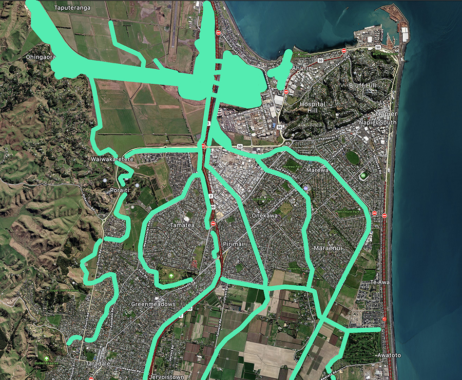
Here is the plan of Napier / Hawkes Bay in its current state with rivers running in green. Pretty much something like this anyway. There were massive river-redirection works undertaken in the 60s I think, where the rivers were gently persuaded to exit out to the East, rather than flowing through the town to the inland sea.
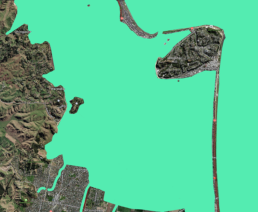
Here is the pre-Pakeha plan of the same area, with extent of the former vast inland sea. When it floods, clearly the old forms of water paths may take precedence again.
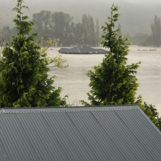
View from the Esk Valley ? towards the open sea – the sea is the brown stuff on the left, and the land is the equally brown stuff on the right…

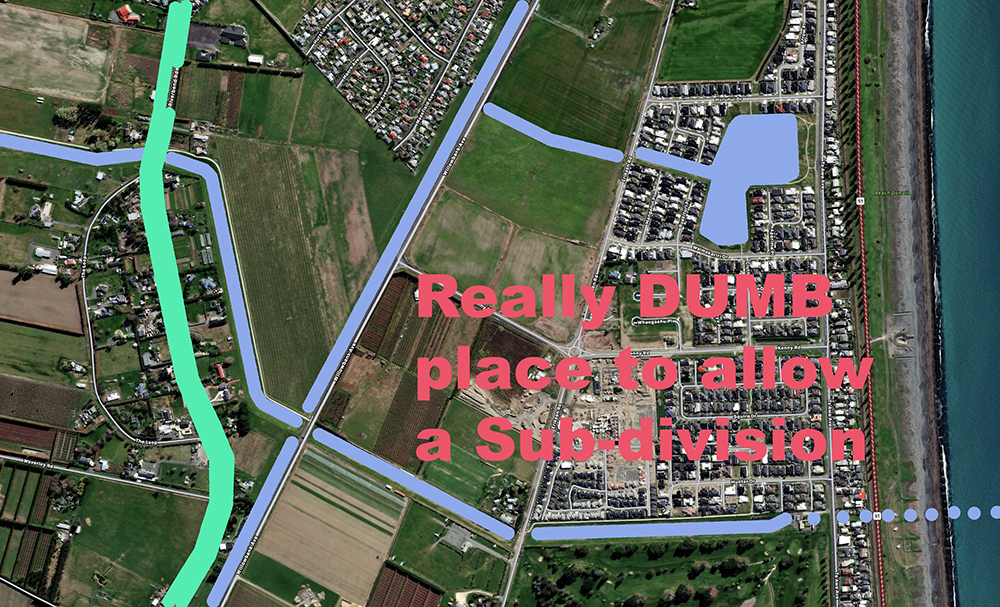
And finally, here is a comment from the Eye of the Fish, about the sensible placement of the latest subdivision in Napier.
5.54pm: Residents of a Napier retirement village have been forced to evacuate twice since last night because of the threat of flooding. A spokesperson for Summerset Villages, Logan Mudge, says Summerset Palms in the seaside suburb of Te Awa was cleared last night and again this morning on Civil Defence advice. He says it appears the houses themselves are safe and dry, but the flooding around the village makes it unsafe to stay there. Residents are at evacuation centres or with family and friends. Hardly surprising….


” idea of building on a flood plain?”
The problem is that pretty much all large expanses of Flat land in NZ are in one way or another alluvial fans
I am expecting to see a significant review of all of the Hawkes Bay flood protection schemes (eka a whole bunch of new bigger wider stop banks)
The question is will the government extend this to a review of *all* river protection schemes around the country as part of a huge “climate resilience” project –
With a big climate tag hanging on it it can be funded out the ETS slush fund that they used for a bunch of other stuff at the end of last year so money really isn’t an issue…
So right, Greenwelly. We deceive ourselves that because we have the same land area as the UK, we are therefore underpopulated but as you say we have quite limited flat land a lot of which is prone to flooding. When it is not flooded it can be farms or houses but only one at the expense of the other. Is it time for a realistic discussion about our goals as a nation? What standard of living do we aspire to and where is the population tipping point beyond which our standard of living goes backwards? Should cities like Wellington being taking one for the team and allowing houses on all its land given it has very little productive potential?
Greenwelly – the stop banks in Hawkes Bay are already quite tall and quite wide apart – this event was unprecedented, and of course may never happen again that bad. Or, I hear you say, perhaps it will occur yearly in the future? Certainly the sea is not getting any cooler – the Coral Sea is where the Cyclone picked up its heat and water. Of course, it is a little ironic that what they are missing now is heating and fresh water…
But there are some things we can do, which I’m going to publish some pics above – the new subdivision at Te Awa is a ludicrously stupid development, given that it is at (or below) high water level. So, it actually relies on the pumps working 24 hours a day, and particularly about the high tide mark. In theory that’s fine, but when there is a power outage – as there is now – then flooding is not only likely, but almost compulsory. If there is no power for some weeks on end, then no pumps, and therefore compulsory flooding for the 1000 new homes and the massive new retirement village at its centre…
Out of idle curiosity, how much of Greater Wellington relies on pumped stormwater?
I really don’t know – but I would hazard a guess that maybe the Hutt does, in some capacity? Their stop banks provide a natural barrier to the river – but if the river banks break, then water will be equally trapped behind them.
Wellington, by contrast, and as far as I know, has storm water running naturally gradients to the sea, but of course we have to pump the sewerage across town and back… heavens only knows we don’t want THAT pump to break down again !
There are these things that allow water to drain, I forget the name
Basically a big top hinged gate at the end of your pipe
Look like this
https://www.awmawatercontrol.com.au/products/flap-gate/
I have seen one on the Hutt River for draining water from behind the bank back into the river but of course only works when the river falls enough to allow it to open
In Bunnings Lyall Bay today a bloke was struggling to load a genny into the back of his 4WD
I stopped to help and asked how he was for help at the other end and he said he was back to Napier tonight
I hear there are a few more bodies to come but this got me in the feels
https://www.rnz.co.nz/news/national/484331/video-shows-cows-responding-to-farmer-s-plea-to-swim-for-their-lives
That was a lovely video – that those cows should respond so well to the call of their owner! It is still a wonder that animals put their faith in us, when we abuse them and slaughter them. Bunch of brave old girls…!
This may sound a bit heartless to say, but it is worth stating, and remembering. Esk Valley is a river delta eg it is a flood plain. Has been so for the last 10 million years.
Yes, you are absolutely right – the Esk Valley is indeed a well-known flood-prone area. It has flooded many times before and will flood again. Indeed, the whole reason all that rich soil is in the valley, is because it comes from previous floods. There are not big tall stop-banks there (there may be some smaller flood banks), but the Esk has a pinch point near the “top” of the valley – just before the Napier Taupo highway hives off to the side – and the river builds up behind that pinch point and then fires out in a concentrated burst.
The good thing is that there are actually not that many people living there – and much of the housing is sited on the sides of the hills that surround the valley. Probably the most sensible thing that the Gov could do is to permanently ban people rebuilding their house back on the flat areas.
One question I have is – How is the old Eskdale Church? The most beautiful church in the district? No one has spoken about it yet, but does that mean it escaped unharmed? Or has it been wiped clear off the map?
Answering my own question here:
https://www.stuff.co.nz/national/131331744/historic-eskdale-church-withstands-second-devastating-flood
The Church is fine. Wet and soggy, and probably the carpet will need to be replaced again, but the church is fine.