
My fledgling tender buds that started to like Chris Bishop and think that he may have a brain in his body have been trampled on. I’ve gone back to thinking that he is a complete and utter plonker, because, well, dickish behaviour. In short: He has put the RONS back on the table.
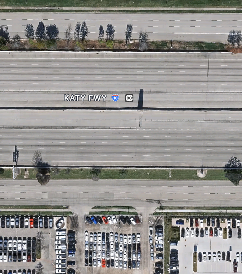
Most of it goes to Auckland, where roads reign supreme, and logic fails to register. Having just watched a video on the Katy highway, from Houston to a smaller city called Katy, where they widened the highway to 13 – yes, THIRTEEN lanes – in EACH direction – and it still clogs up each day – Jesus H Christ, how stupid can you be to think that anyone can ever build their way out of traffic congestion.
But in Wellington, once again we have some projects back on the planning table. Will they ever happen? National and the Trucking Lobby say Yes. The Eye of the Fish says No, probably never. Two projects, each more stupid than the other.
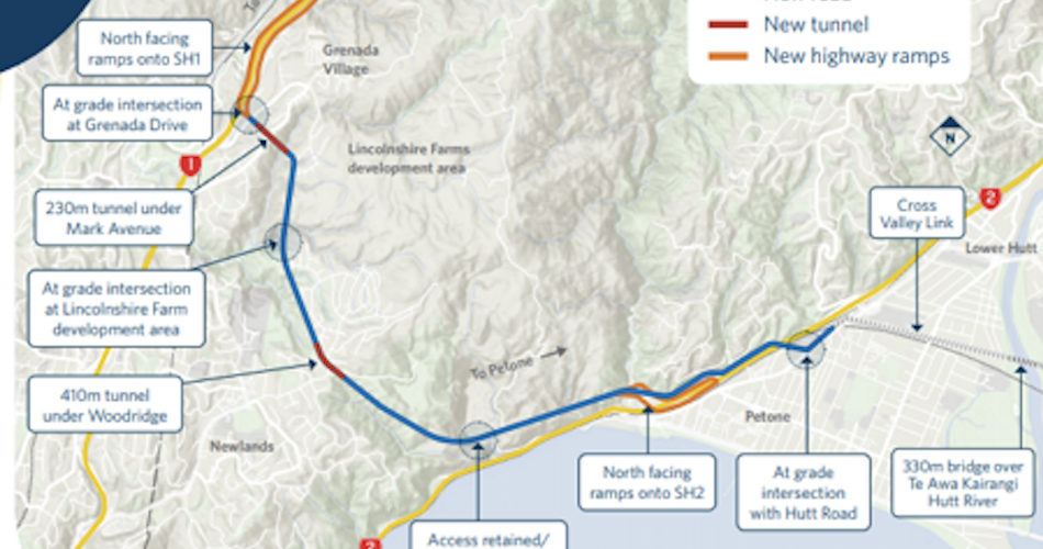
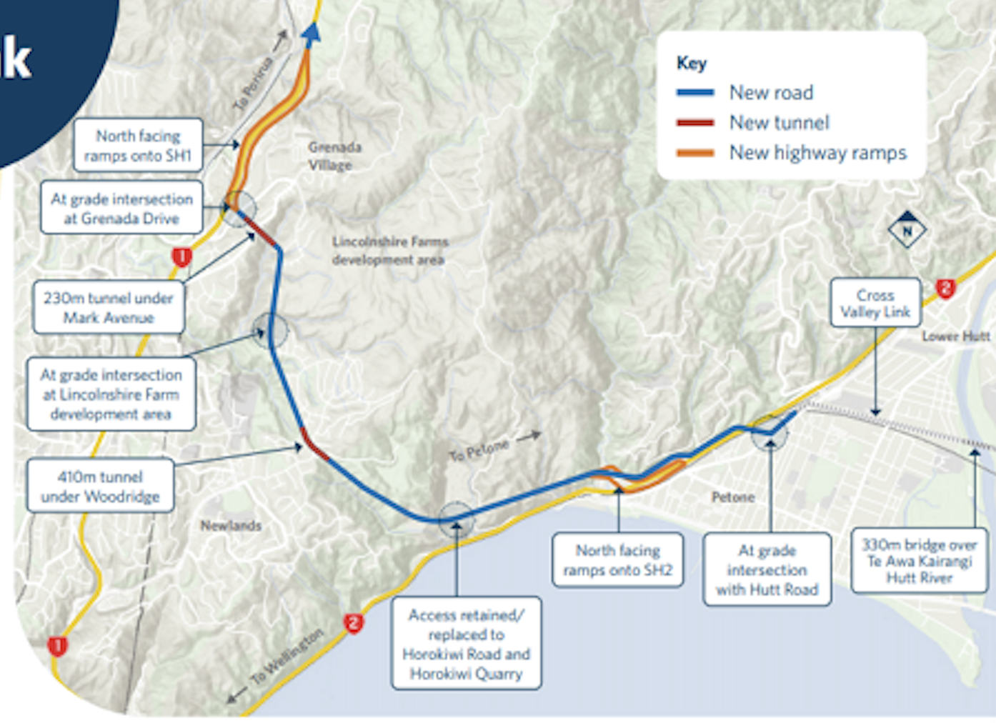
Petone to Grenada – utterly pointless waste of $2.1 to $2.6 BILLION. But thankfully, they now have a route which uses 70% less digging than before. Before it was one of the most expensive and useless roads in the world. Now, it costs more, but inflation means that it looks like it is more affordable. No, it isn’t.
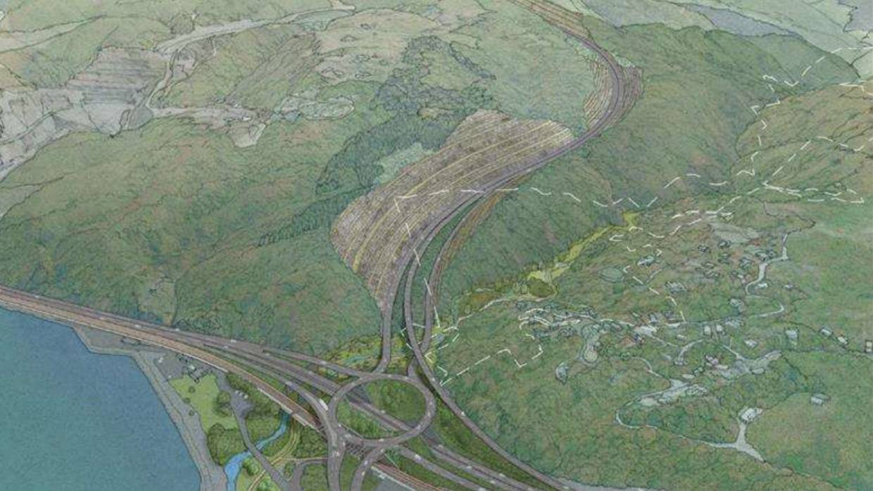
Here (above and below) is the plan from a dozen years ago from the RONS team then, showing a snake blue line that traversed across Horokiwi over the plains on the top (up in the cloud level) and with a god-awful tall cutting, up the valley right next to the Belmont Regional Park. From memory, it would have been more effective to pave a highway to the moon rather than to do this plan, and NZTA scrapped it pronto. First time they had ever said – “it is beyond us, we cannot do it, it would just be too expensive.”
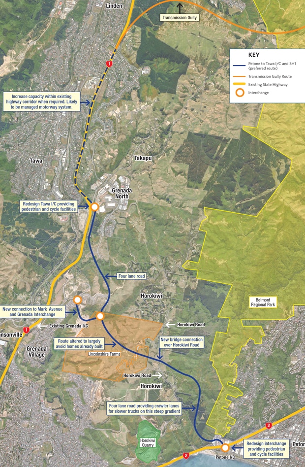
Now they have a new route and a new plan, and the cost has gone up, and the road has gone down into the gullies, because after Transmission Gully, they now know how cheap and simple it is to build a road through a scenic gully full of trees and ferns and streams and shifting shingles, gully floors. Two tunnels, one 410m long, the other 230m long, and several bridges. As a comparison, the existing Mt Vic tunnel is 623m long.
Each to their own, I guess, but it makes no sense to me – just continue down a few more kilometres to the Ngauranga Gorge and then turn left, and back up SH2 to Petone. But yes, that takes time. And to Bishop, time is money. But to me, I’m very happy to save a couple of billion dollars. I’d rather have a train tunnel from Petone to link to the Kapiti Line. And of course, I’d really rather have Light Rail in Central Wellington.
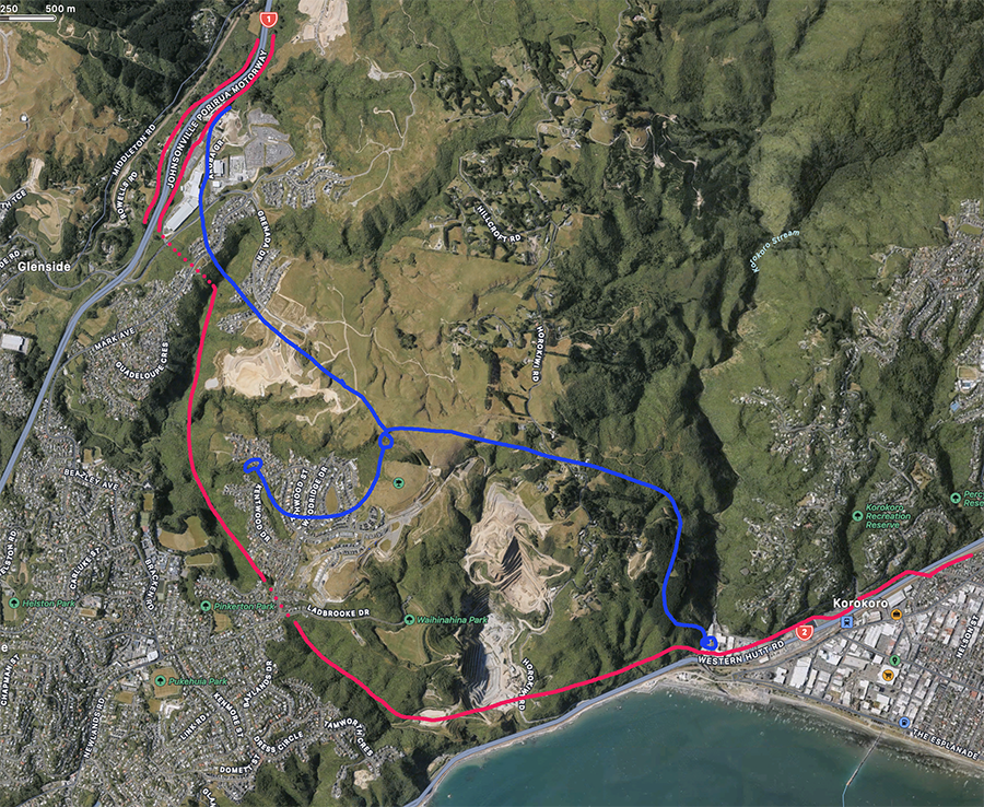
A bit hard to read on their washed out maps, so I’ve done you a nice new crystal clear map of what I think they proposed last time and this time. Red for the latest scheme, blue for the one from 2018 or whenever it was. Before they were trying to go behind it, now they are just simply going in front of it (beware of litigious residents nearby). I keep thinking “why don’t they buy the land off Horokiwi quarry and put the road up through there, as they have already dug it out!” The stone round there is especially hard and gnarly for the roading people to build things with, so it should be a good stable base. Remember, that quarry has been going for 40 years or more, digging the whole time, and they’ve hardly made a dent in it.
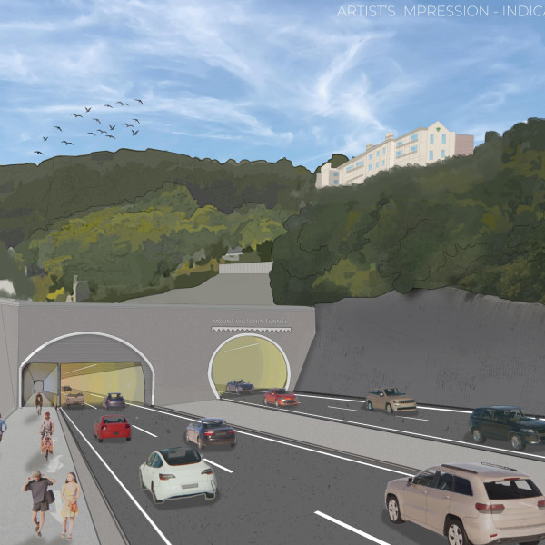
Now onto the main event for Wellington. A proposal to do all sorts of things to the centre of Wellington. Haven’t we been here before? Here is the picture to scare off the people who currently live in Paterson St – not for much longer !! So – parallel and to the north of the existing tunnel – I thought that they would be going diagonal and to the south of the existing one. But no. Looks like they are aligning once more with the pilot tunnel, which should really just be left alone. It is actually easier to build a new tunnel than to have to eat up the existing one.
And here is the plans to scare off the rest of us. So simple, so unspoiled and pure and simple, much like Minister Brown.
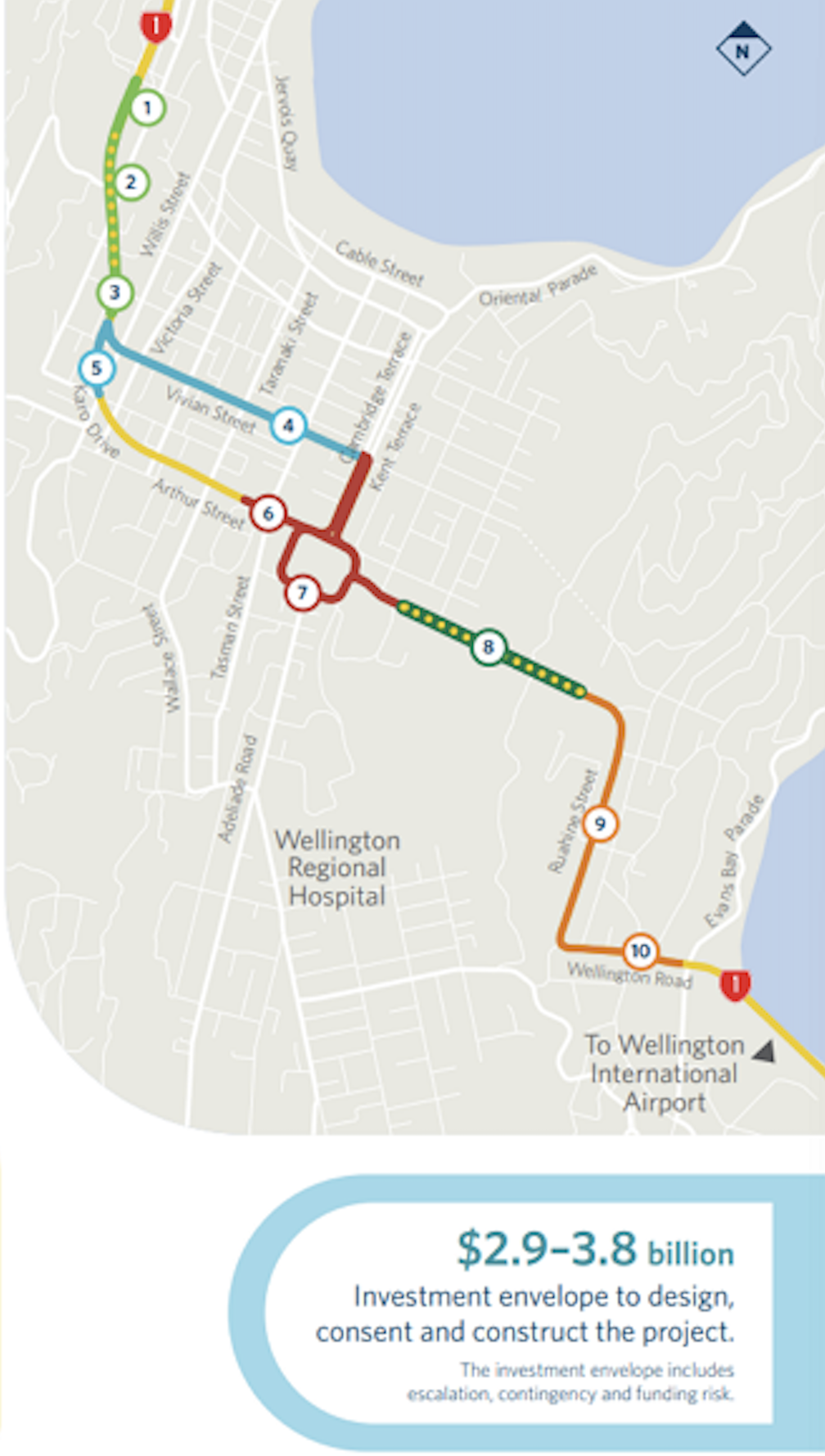
Not sure that I believe any of this, but here is what Bishop proposes.
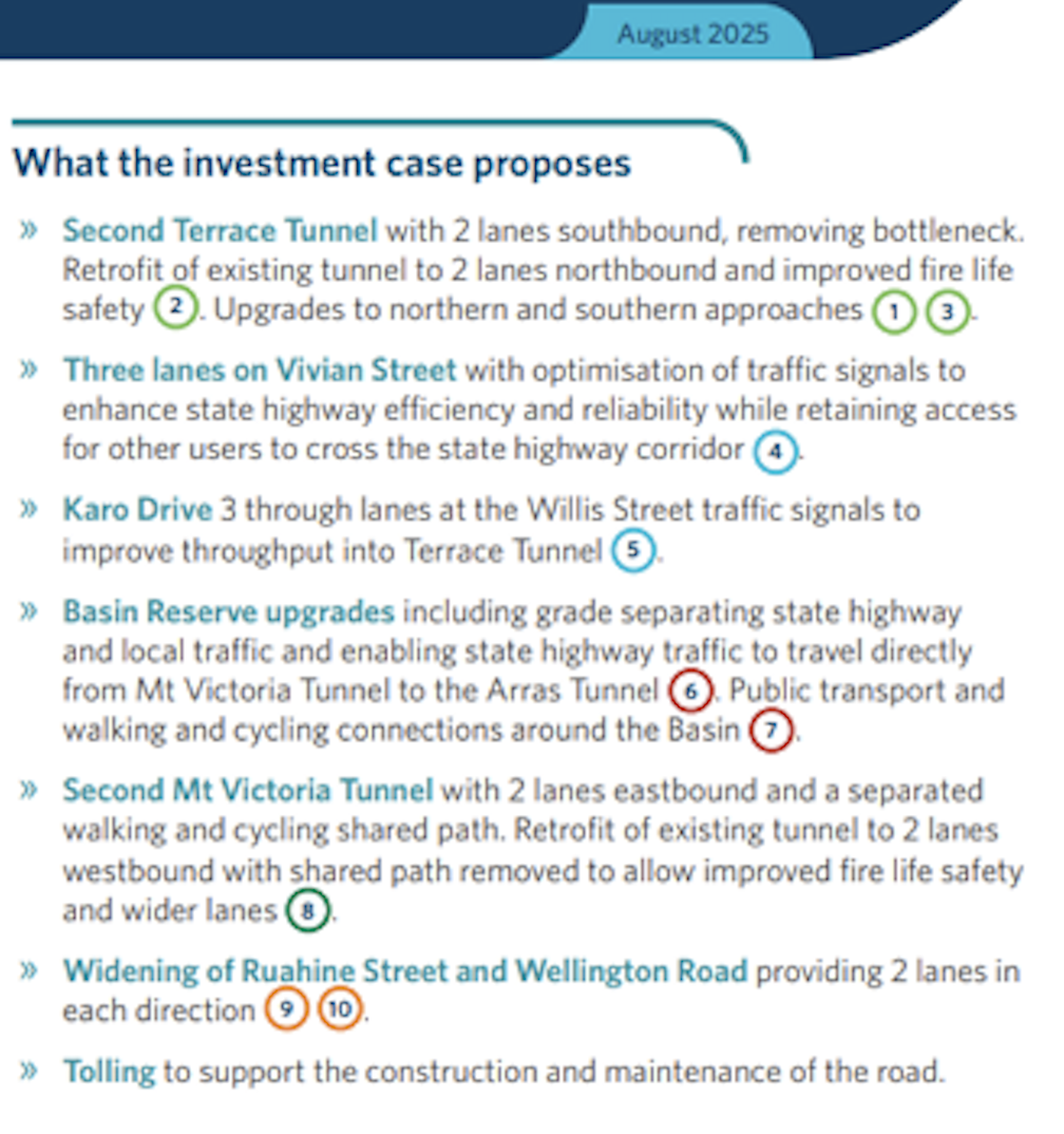
I would reply to this proposal to “solve” our traffic problems very simply like this revised sketch proposal below. Not everyone will agree – the Save the Basin crew and the Mt Victoria Residents Association will no doubt be girdling their loins as we speak (although, I confess, I still have no idea what a girdled loin actually is).
Three-laning of Vivian Street is my real hatred – the traffic already hoons through there at an almost motorway speed at times – on my infrequent trips up that end of town I despair over how badly the Cuba Street area is chopped in half by this hideous SH1 route. Can’t we underground it? Please?
Post-script: Or can we not have a really good think about how to make Karo Drive two way? And free Vivian for ever?
Post-post-script: Couple of blow-ups enclosed here for the readers…

Also discussed over on Scoop: https://wellington.scoop.co.nz/?p=175029
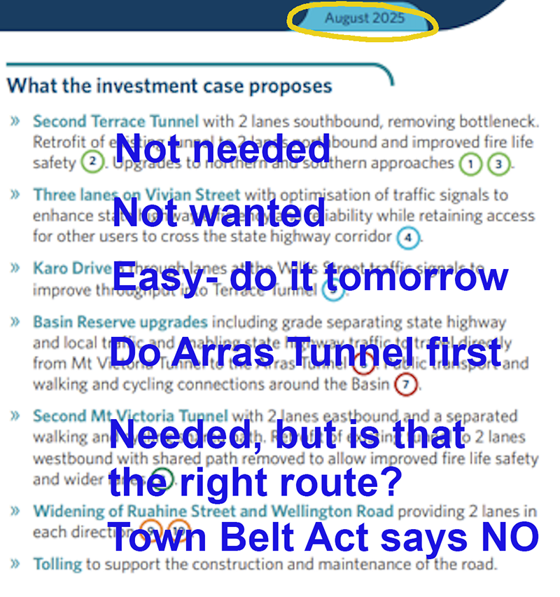
Is there a hint of things to come in the picture of the Mt Vic tunnel – where the pedestrians are just about to be wiped out by the dude on the bike. What are they trying to tell us? Is it a cry for help?
And is there an outline of a body lying horizontal on the footpath, just above the dude with his hands over his ears to block the sound? What is going on here??!
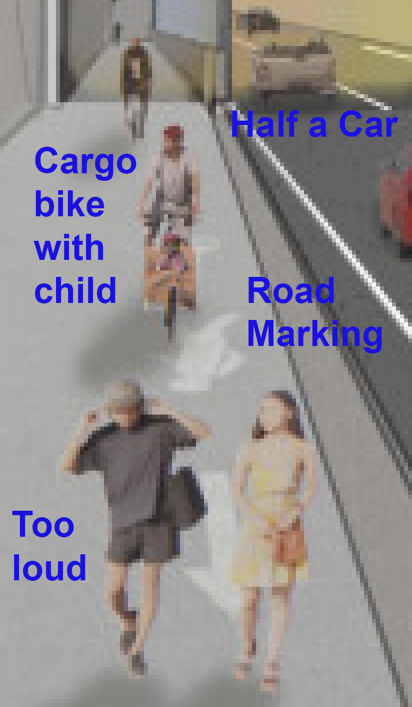
By the look of it you’ve got better eyesight than me – are those seagulls or vultures hovering above the shared path?
Thank you so much for the map with two options for the grenada petone project. That has made life much easier!
My pleasure Måmari – i really can’t understand why NZTA don’t do this themselves, it would make it so much easier, and a lot more accurate than mine. My guess is that to get from the previous plan to the current plan, would have taken numerous other route plans, till they found the “right way”. One of their guiding principles (at least it should be even if it is currently not), is to devise a route which has XX m3 of excavated soil, and requires the same XX m3 amount of fill to be supplied. I suspect that the previous option may not have worked for that reason – it was highly unbalanced.
I know it was said in jest (perhaps?) about just using the quarry to shortcut over the hill, but as someone who has been on site and driven up to the tippy-top of it, I can tell you that the grade is super not suitable for regular cars at all.
Yes indeed – I’ve been up there as well, and yes, it is a working quarry – massive steep wall at the end of the cut. Not suitable as a road at all, at this point in time.
BUT – and it is a big old butt – if you have a plan for a road, and someone has already been digging for 40-50 years, and created a big hole, why not use that hole as the work has already been half done? This project is a MASSIVE project.
I can’t find the figures at the moment, but in the “Old” route plan, there was a rough calculation that they would need to excavate about 8million cubic metres of rock. And when I looked into what Horokiwi had already excavated over the last 40 years, it was a similar amount. Which just shows how big the project is.
Although a Million cubic metres of Rock, isn’t what it used to be,
TG was 11 million odd, The new Manawatu/Tararua Road was 6 million, Puhoi to Warkworth was over 10 and even the “little” Mt Messenger bypass (cost $300 odd million) is moving over a million cubic metres…
Although its sounding like this road will have to suffer the slings and arrows of a few more electoral cycles before we’re likely to actually see it built.
“No estimated completion time for the Petone to Grenada road has been given, however a summary of the investment case already released showed the planning and property acquisition stage may run until 2030.
“It’s a long-term transport infrastructure pipeline,” Bishop said, of the road building programme.”
https://www.thepost.co.nz/politics/360864363/wanted-designers-billion-dollar-wellington-nelson-roads
“It’s a long-term transport infrastructure pipeline,”…..
So…. never going to happen? The Nat / ACT / NZ Wurst coalition will be very stale toast by then. I suspect this depends solely on how much the various trucking lobbyists will pay for National’s junkets away to Tahiti.
But the roads through central Wellington will happen much faster, as NZTA already own all the land…
Yip, A second Mt Vic Tunnel has really been a fait accompli since the 70s, because traffic now banks up round the basin like a hair clogged shower drain
NZTA have had multiple attempts to get it funded, heck they even manged to get it into LGWM, and TBH I suspect even the new Mayor will support it and the grade separation….
As for an additional terrace tunnel they can probably live without it for a while … but the Basin is a problem that pretty much everyone agrees needs to be fixed…
What are the chances of a logical staging of this work? Example – basin first with arras tunnel extension, then 2nd Mt Vic Tunnel, then finally 2nd Terrace tunnel (which I suspect may not be needed after then former two projects are finished).
And second question. Does anyone know what the best/most sensible solution regarding the Arras tunnel is?
I don’t think it’s wide enough to take 4 lanes. I assume widening is more difficult than digging a new one, so does a new one to the north of the current tunnel make sense, two lanes cut and cover on the land of Gazeley’s, the soon to be abandoned Te Papa archives, the Mt Cook preschool and out somewhere in that carpark parallel to Martin Sq?
Pedge – you’ve got to hope so! Yes indeed it should be done in stages, and the only logical thing to do right now is to take Sussex St in a small bridge over a lengthened SH1 tunnel at Arras. If you do that first, then you have got grade separation at the Basin, which is THE main problem at the Basin. As you say, do that, and the need for a second Mt Vic and Terrace Tunnel may well go mostly away.
Te Aro School is probably the sole reason why we :
A) have an Arras Tunnel in the first place, and
B) won’t be able to add another tunnel in the other direction.
It’s politically impossible to close down a Primary School for a roading project.
As the erstwhile author of a Te Aro School history, I can confirm that while it has moved around a bit over the last 120-odd years, it has never been anywhere near the Basin. These days it’s actually up on the Terrace – quite close to Kelburn. You must be thinking of Mt Cook School – which is really in Te Aro.
May Week was in June, the August holidays are in September, Te Aro School is in Kelburn, and Mt Cook School is in Te Aro.
What me confused ?
At the end of the day, the only thing to do with the Basin Reserve I’d to move it somewhere else thus simplifying the resulting Paterson/Arras and Adelaide/Kent/Cambridge intersection.
But where to put it?
No need to do that. See Kumara’s reply below
I’m not convinced, but in any case, how about decent pedestrian bike, and taxi access, be it by underpass, footbridge, or cab rank?
Decent pedestrian, bike, and bus access? I’m all for that.
Not taxis – taxis are dead.
Uber and Didi – are just cars with bad drivers.
Dear Mr Filth, I’m not sure if you were around in Wellington back in the days when the Basin Bridge Debacle was being Debated, but the traffic modellers at OPUS did eventually reveal that they had a good look at all sorts of traffic options, although the Public were shown only 2 of those. Options A and B, both via a Bridge over the edge of the Basin. What became apparent over the course of the BBD was that it Wass NOT actually the Basin that was the problem – it was actually that the East-West traffic (to and from the airport / SH1) clashed every day wth the North-South traffic (primarily local traffic), often to and from the ridiculously large number of Schools sited at the Basin. Get rid of the Schools access from the Basin and that would be half the problem solved.
Fortunately I managed to miss most of Wellington’s 2010’s traffic planning circus, whereby half a squazzabazillion dollars was neatly stacked into piles, sprayed with kerosene, and incinerated.
However I do think you have highlighted what is possibly the main issue – the enforced merging of both local and through traffic into a single point of confusion, congestion, and carnage.
But maybe the answer is, as you suggest, to move the Wellington schools. After all, if St Pats (town) can successfully relocate to Kilbirnie, surely. . .
Unfortunately they seem to be rather keen on staying exactly where they are, warts and all. Double unfortunately, the mothers who drop off / pick up the little darlings outside the School gate, destroy the traffic flow for “ordinary” Wellingtonians. That was the clever thing about the Option X project by Arch Centre:
A) it grade separated traffic, but with a short N-S bridge instead of a long E-W bridge.
B) it also discontinued the roundabout in front of the Schools and made the little buggers walk or cycle through a Park instead.
C) it relied on having a tunnel, which at the time the Government said they could never afford to do – and then they did it anyway, so it is actually the easiest decision for Bish and Bash to make.
I recall the petrosexuals’ favoured option of a flyover was denied consent, and the alternative Option X was put forward by the Architectural Centre:
https://savethebasin.org.nz/alternatives/
This is the correct answer – and is the route that the Gov will be taking – there is no real alternative
Cheer up Wellington. At least you are not getting a Hope Bypass like Nelson.
Bypass All Hope, All Ye Who Enter Hope.
Worst thing is that, I guess, Mayor / former MP Nick Smith will have been lobbying for that…
A couple of things Nemo since I worked with that site for 5 years as part of a landscape architectural investigation. The rock at Horokiwi is far from gnarly and hard. There is a lot of weathered greywacke and it is incredibly fractured. Being so close to the fault line has left it quite weak. There are veins of argillite which is much harder, but its mainly through a formation that runs through the lower half. Also the quarry has been operating since at least the 1920s if I remember rightly. They have taken an extraordinary amount of material from there, not exactly “barely making a dent”.
To run an elevated road right in front of it is a travesty to this hybrid landscape condition.
Thanks Shaun, and good to have some actual real life experience on the site. I was merely assuming that if it is a quarry, for quarrying rock from, that therefore the rock must be of suitable proportion / hardness / amount of fractureness / whatever the term is, for it to be suitable for road building, seeing as they are using it for building roads from all around the district? You see my logic?
And re “hardly making a dent” = if you refer to my aerial map, with the Blue and Red lines on it, you can see that despite having been digging for 100 years, the amount dug out is only about a fifth of the length of the needed dig for the Petone-Grenada link. I’d say that 100 years for a fifth of the length is pretty slow going, compared to what they will need to do in 2-4 years for the whole link? You disagree?
I loathed the old Petone-Grenada proposal, but I really like this new proposal. Whereas the old proposal favoured a deep dark gloomy trench up a very steep incline and an unsightly scar on the landscape, this new proposal promises to be a scenic masterpiece, offering views over the harbour, a tall & scary viaduct with the sea on one side and the quarry cliffs on the other, forest and farmland views, and a couple of tunnels for added interest: this could be one of the most visually stunning roads in the Wellington region. For first-time or holiday visitors to Wellington, it has the potential to deliver a superb visual reveal that could make it the recommended tourist route both in and out of Wellington.