
Slowly but surely, at a majestic but glacial pace, Let’s Get Wellington Moving are moving forwards. Well, moving, at least. Maybe it is forwards. Maybe it is sideways. But at least it is not backwards. They’ve released some proposals, and want your / our feedback. And that means it is time for a closer look.
Evidently, LGWM are working on this whole project bit by bit. And for today, this bit of the whole package is the detailing of the Golden Mile, in closer detail than we have seen before. While I can understand that they need to move forward, and that this is the only piece they have “consulted” on before, I find it frustrating, and more than just a wee bit stupid.
If I was in charge (and quite obviously, I’m not, and never will be), I would make the big decisions first, like: what sort of high speed rapid public transit system are we having? And secondly, what is the exact route it is travelling? Because, after all, those are the most important decisions of the whole project. And thirdly, how does it connect to our existing mass transport systems, because that is the only way that we can get passenger numbers to flow through at the current junction.
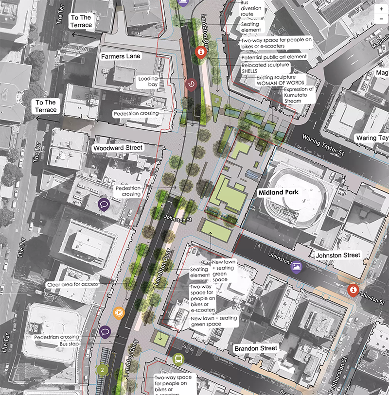
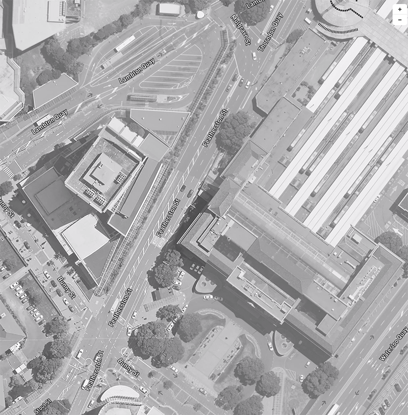
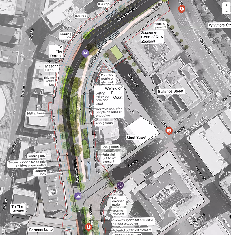
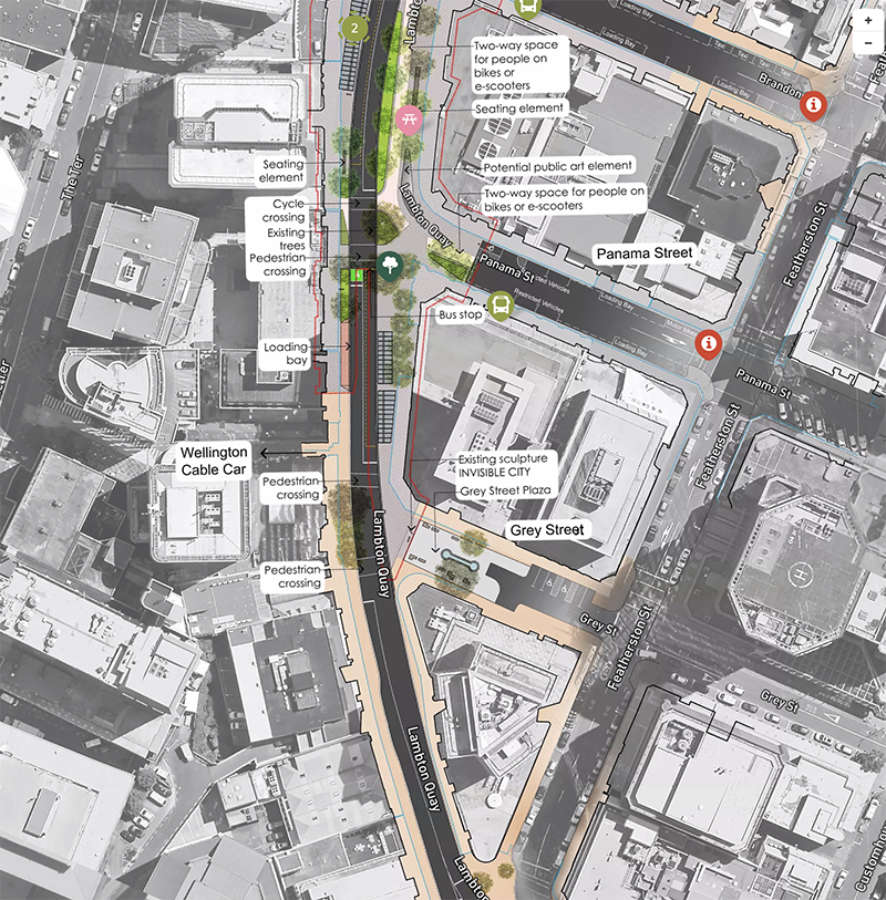
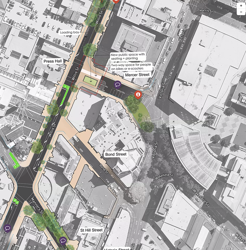
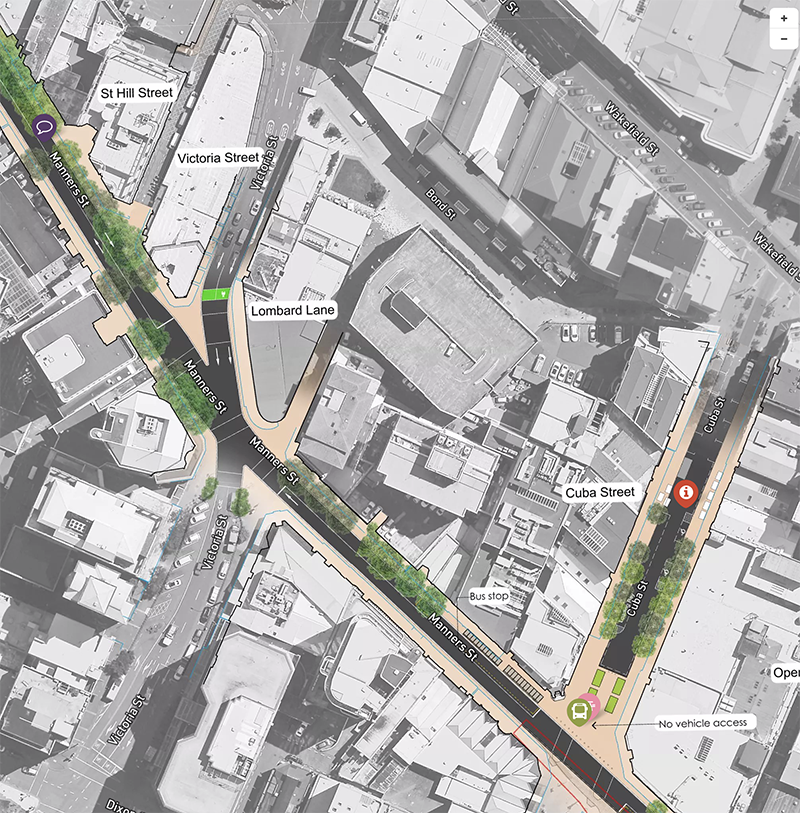
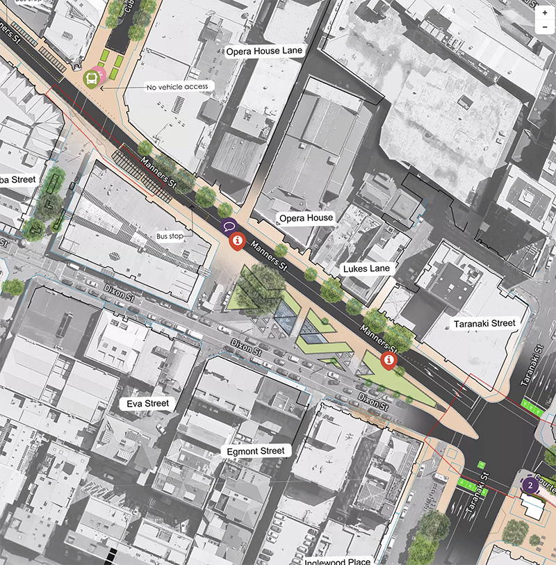
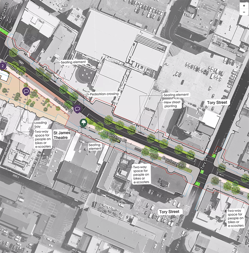
But instead, LGWM are doing this piecemeal, and are just showing the Golden Mile, so I’m placing these blow-ups of what they are planning here, all at the same scale, so that you can see what is proposed. The website must be quite expensive, to say the least, and there is no indication over who is actually doing the work – is it one traffic consultant, or is it a consortia of architects, traffic engineers, landscape designers, etc, and who are they?
But the cool thing is that it seems that people’s comments are being retained, live, on the map, so that we all can see what other people are saying. Perhaps people get to choose their own logo? There’s evidently a Landscape person who has been quite vocal already – and the site has only been open for a day so far!

It’s a wee bit frustrating – very hard to really see much detail on a laptop, but the more you zoom in, the more detail you can see – although it is still very far away from doing actual working drawings. And while most of the decisions are sensible and entirely predictable and logical, some of them are a trifle concerning, to me.
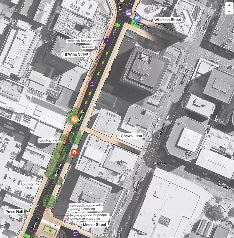
The most concerning to the Eye of the Fish is that LGWM are proposing something that retains existing pinch points and does not address them in a way to ensure that the LGWM will not / cannot clog up. And to me that is a vital point. The Golden Mile is being retained as a way for the buses to be retained, from end to end, allowing the Waterfront Quays to be used as a route for Rapid Transit. That’s fair enough.
That also means that the bus-route (eventually, they will all be electric, and quiet, but for now still belching diesel fumes out at everyone walking) – the bus route absolutely needs to keep flowing. As we know, the bus route is already clogged, but this pressure will be relieved at some point in the future, when the RT starts up a hop, skip and a jump away along the Quays.
But we also know that buses can, and do, break down, and electric buses are no exception. There will be the need for the massive breakdown truck to get in and tow away a dead EV bus at some stage – so we always need to retain room for that to happen.
In fact, access for trucks of all kinds is one of the most vital parts of the plan, and something that I sincerely hope that LGWM have been furiously consulting on with every retailer and office dweller along the Mile. Putting it bluntly – how does McDonalds get it’s fries delivered to their door (and a thousand other businesses as well).
Obviously no one needs to get a car park outside Kirkcaldies any more – and it hasn’t been that way for years (I know, I know, Davy Jones locker etc, but honestly, that was never going to work – department stores have long since had their day) – but I guess that some buildings still have basement car-parking that they would like to access? And of course, Ubers and Taxis need to be able to get close to pick up those that cannot walk that far – or all of us, when it is raining.

So all those side streets now abut up to the edge of the Mile but go no further (Panama, Brandon, etc), and that all makes sense, except for the exceptions. The major junctions where we know there will be a major junction dysfunction, where Public Passenger Transport clashes with Private Transport. Where Car meets Bus, and where Bike meets Pedestrian, and where the rubber meets the road. Those junctions like the Mile vs Taranaki St, for instance.
Or the main pinch point and junction in the city for the last 182 years – around the Old BNZ corner, or Stewart Dawson’s corner, Windy Point or Clay Point, whatever you want to call it – have they resolved that clash point of transports here, yet, in these plans? Voice your comments below.
And of course, put your comments on the LGWM interactive map – and most of all, send your comments in to LGWM – we have until 14 August, only one month away. Email them at goldenmile@lgwm.nz


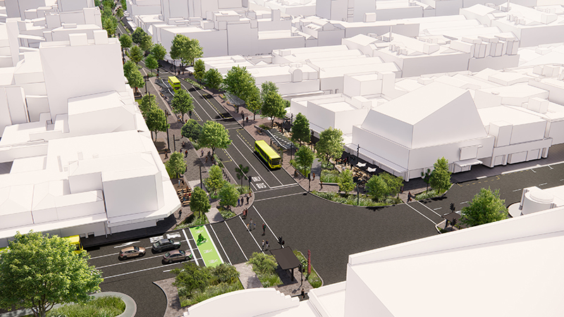
There are many more rendered pics on the LGWM website – go have a look.
I love how they don’t appear to have any standard for cycle lane separation, (despite in their “easy wins” in places like the Brooklyn Hill/Crawford Rd/ Adelaide road needing plastic curbing and “bang sticks”
The reason for this conclusion is the apparent recommendation that cyclists travelling northward on Willis street should do so BETWEEN OUTGOING AND INCOMING BUS LANES WITH NO PROETECTION, and in Manners street the cycle provision just stops totally ……
Also all of the increases in Bus travel times are pretty much the result of removing bus stops,
– while its fine now not having anything at the Reading Cinema Site, eventually this will be redeveloped, and will also be one of the main linkages to the Convention centre ( the other one is presumably the LRT/BRT that will go on either Cable or Wakefield st ( the LGWM fold seem very cagey about how that will all work given there will be major traffic conflicts at Taranaki St and the Kent Terrace crossovers- apparently they have eyes on the Taj Mahal/Welsh Dragon building, but Heritage will likely save it)
Yes, greenwelly, you’re right there – the cycle lane comes and goes at will – mostly goes. I would make this comment to ALL the good people at LGWM, should they ever happen to see this post / comment – that they should take a commercial Scooter for hire, and try and scoot down the length of Lambton Quay themselves. Private scooters may be able to go faster as they are not speed-restricted, but the Flamingos and Beams that I use on a daily basis are restricted to about 15km/hr, which is precisely half the very low (30km/hr) speed that cars and buses are restricted to. You can’t cycle on the footpath, as it is full of pedestrians, and they are as likely to punch you as get out of your way. But cycling on the road way in a bus lane, with a 35 tonne double-decker bus full of people who want to get home or to work as fast as possible – that’s an absolute bloody nightmare.
Goes back to my first comment: plan the entire network first, THEN come back for the details. You want a full length Golden Mile cycle way? Then plan and implement that first, not last.
Too many minor issues to comment on here, will instead do so on the consultation page if I can bring myself to do so.
Overall:
1. it’s a bit mental to design this route separately from the other mass transit route (presumably the Quays) but you made that very sensible point already;
2. e-scooters @15kmh also go half the speed of grown-up commuting cyclists so will get in my way when I’m headed to work or home up LQ;
3. I’ll pay you $5 if the surface of the cycle/scooter-way isn’t so slippery as to be hazardous, or if the bus lanes aren’t so narrow as to allow buses to pass each other (both in opposite directions or when playing leapfrog), or if the trees last 5 years – we all know that they’ll fuck-up the design details;
4. pedestrians will stomp all over the cycle/scooter-way and cause accident like they already do with bus lanes;
5. the dead-end roads will be a nightmare with Featherston Street remaining one-way unless more of those side streets become 2-way to the Quays (people will still drive, including in Ubers – and there will be deliveries…), as they’ll all be heading north for blocks up the (narrowed) Quays before doubling back south along F St to get to their carpark/shop/apartment; and
6. the reduction in bus stops probably = 75% of the time benefits. Make that 100% when you move newtown and island bay buses to the Quays.
I think we need to appreciate that this isn’t about getting Wellington moving – all those benefits can be achieved without this – it’s an urban regeneration scheme hiding as a transport scheme. Which is fine, just be honest about it.
The other thing that bugs me is the lack of integration with this plan, It stops at Bowen street and Cambridge Terrace,
Yet, the key transport destinations are (will be) the railway station interchange and the LRT/BRT junction in front of the Embassy theatre, Also now that Courtenay place is closed to private vehicles the huge C/Place junction can be significantly redesigned to allow seamless transfers from the BRT/LRT to buses (which have to happen for the MRT to achieve anywhere near the required ridership)
But NO, we just get a $100 million spent on pavers/footpaths and trees, and as you say no real PT improvements,
Exactly !!! We need linked-up thinking – a complete co-ordinated masterplan, and as you both say, the junction points are the most important. Golden vs Taranaki / Wakefield / Cable is one. The end of Golden at Courtenay vs Cambridge / Kent Marjoribanks is another. And I suspect that, as always, Stewart Dawsons corner will be the third.
So far, they only have a solution for one major sticking point – the Basin. And that took nearly 15 years to get there – and they haven’t even started building it yet.
This is going to be a long, slow, exhausting process….
The reason it’s like this (ie piecemeal) is because nothing ever happens on MRT, and people and councillors are sick of using that as an excuse to do nothing.
Yes – at the pace that LGWM are going, it may well be another century until there is actually real work completed. No – that is not exactly true – their first work was to fix the kerbs on Vivian St, which they started on one intersection about 3 weeks ago, and have not yet completed. Vvvvvvveeeeeeerrrrryyyyyy slooooooooooooow moving.
Don’t worry about the pace, they’ve apparently got a budget of $120 million for the detailed business case, given that LGWM already has a bunch of staff I’m guessing a fair whack of this will make its way to the usual suspects, (MG Cagney, WSP , Stantec) along with the regular big boys of EY, PWC Deloitte etc, )..
This is a huge consultant money go round….. with very little output….