Yet again the Dom Post is going all out for Click-Bait headlines, with front page news alleging that “Character homes may go”. That’s a title worthy of April 1st, not April 3rd. Perhaps a new boy on the news desk, trying to turn a few heads with spurious bullshit. Fonseka: back of the class for you mate! Time to grow up and write a serious, well-researched article, the sort of thing you are paid to do – the sort of thing I do for free, in my limited spare time.
So, with a view more to the truth, what really is happening?
Four different scenarios have been proposed to the Wellington City Council, by landscaping / planning practice Boffa Miskell:
THE FOUR SCENARIOS
1.INNER-CITY FOCUS
This would see the bulk of the tens of thousands of Wellington’s extra people accommodated in denser living conditions in its central city.
That would include in high-rise apartments more than 15 storeys high in the CBD and six-storey apartments in central city suburbs such as Newtown and Adelaide Rd.
Part of allowing the development in those inner-city suburbs would involve paring back restrictions on re-developing and demolishing 1930s townhouses to allow apartments and townhouses to be built there.
2: BUILD IN EXISTING SUBURBS
Wellington’s suburban centres are more resilient than its CBD and this scenario focuses growth in those areas.
A lot of growth would still take place in the CBD and inner suburbs, meaning “reducing or removing” pre-1930s character houses in favour of townhouses and six-storey low-rise apartment blocks.
3: GREENFIELD – NEW SUBURB: OHARIU VALLEY
Completely new greenfield developments would be more resilient but carry heavier costs.
Council envisages creating a completely new suburb on rural land in the Ohariu Valley accommodating 11,500 people in 4000 homes.
“Significant” infrastructure investment would be needed in everything from water to transport.
4: GREENFIELD EXTENSION (TAKAPU VALLEY, HOROKIWI, OWHIRO BAY)
Growing the city by extending and rezoning rural land next to existing urban areas.
Lots of infrastructure investment would still be needed but these areas would be closer to existing transport networks than a new suburb in Ohariu Valley would be.
I don’t know about you, but the answer seems obvious to me: Not Option 4. Not Option 3. Neither of those are very good, sensible suggestions. Takapu Valley is patently completely inappropriate for building new housing in – have you ever been up that road? It’s barely wide enough for a horse and cart in places, let alone another 4000 homes. Horokiwi is similar – inhospitable countryside, all over the windiest, rockiest outcrop this side of the Grand Canyon. Ohariu Valley is wonderful for people who like horses and leafy hectares of lifestyle block – but access would be a nightmare, as again there is only one road in and out. None of these can be done without an existing public transit infrastructure being in place first: something patently lacking at all of the above.
Owhiro Bay is a possibility – there is existing transport infrastructure, of sorts, in that it is at least already serviced by bus. And there are bare naked hillsides, just waiting to be caressed into shape by delicate strokes of a bulldozer’s blade.
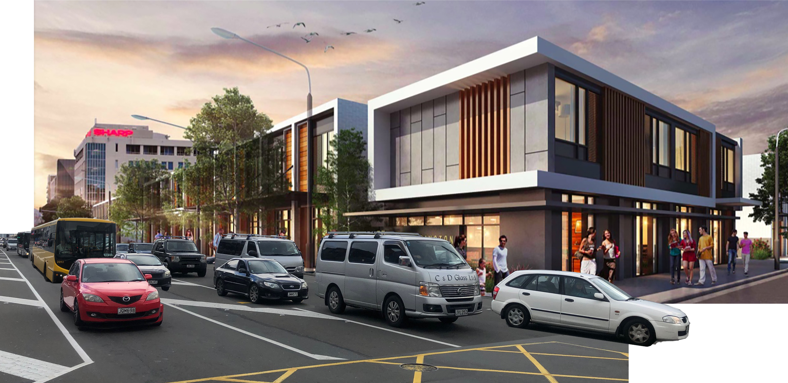
So the real options therefore are simple: Scenario 1 (already doing it) and Scenario 2 (time for the Suburbs to die!). Eighty thousand people is an awful lot of people, but we have fitted 10-20,000 into the inner city over the past two decades without too much of a problem – and we can easily fit another 20-30,000 in without too much problem as long as we have less bullshit development like this in the middle of the city:

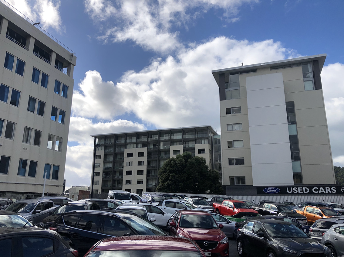
Shouldn’t we be at least trying to mandate more schemes like the Sanctum, sitting right next door?

You can’t see in the photo cos of all those damned cars for sale, but the two wings of Sanctum apartments are surrounding a floral garden at ground level, something the new hotel in the old office building has made swift and clever use of, as a centrepiece to look out onto. I’m not a fan of Corbusier’s radiant city planning, but here the blocks on piloti and boulevards of green actually do really work. Everyone has a balcony and a decent view, average density is medium to high, and Fletcher Construction built it, so it should be well-made.
Instead, there is plenty more to tackle in the suburbs slightly further out, centred near a major transport hub already. Johnsonville, your time has come. Newtown, your derelict phase is over. Miramar and Rongotai: step up to the plate. Kilbirnie – time to kill the dullard reputation, and get with the programme. Mind the tsunami as you go! Karori – well, I don’t know what to do with Karori, except that intensification there is long over due, but then so is a solution to their chronic “one road in, one road out” problem. But all of these existing suburbs have almost zero real character housing, have flat sections, or flattish, have existing traffic routes with well established public transport systems that can only improve from here on.
Or are the character suburbs of Thornton, Are Valley, Holloway, Mt Cook, Berhampore and Mt Vic really going to sweep away the old to make way for the new? 73-86% of the buildings in these suburbs are pre-1930s “character” properties – are they really in danger, or is Boffa and Miskell just having a Larf?


What qualifies suburban centres as resilient? The topographically enforced parallel lines of the existing road and rail services seem to point to the Crofton, J-Ville, Tawa, Porirua axis becoming a pearl necklace of higher density nodes to provide capacity and retail mass for those who want to keep their distance from the inner city Gomorrah.
Personally, I am very much in favour of intensifying the (broadly defined) centre – especially Te Aro and Newtown, but quality and variety of multi-storey design seems crucial to make the urbanist life appeal.
But sparky – the problem with C, P, T and J is that they are all so heavily car dependent. Yes, they have the train lines right there, but they also have the MWay and further housing here will inevitably build up to an answer of More and More cars. And quite frankly (sorry), there is just no room to store them in the city.
At least with Kilbirnie etc there is a damn good chance that the new residents will take the bus. (or the shiny new LR if we ever get it).
I guess the big question with the northern necklace is the ultimate capacity of the heavy rail line. If it can be loaded up a whole lot more, then we might have a genuine PT commuter belt on more or less existing corridors. But what scope is there for increased volumes?
There’s a lot more potential capacity if they can open the throat a bit more. Sounds rude, but isn’t. The current rail throat / choke point near the Stadium walkway only permits 3 tracks to go past, reducing a potential 9 lines down to a ridiculous 1 in and 2 outgoing, or some such malarkey. Kiwi rail (or whoever is in charge of these things nowadays) have plans to do a bit more of an open throat procedure, and aim to get 4 tracks. Obviously, if they could buy a little more land, they could get 5 or 6 tracks. But even 4 will speed things up a lot, potentially.
And what will Tranny Gully mean to commuter traffic north of Grenada? It will presumably relieve Highway 1-related pressure on Porirua and Tawa, but do nothing for the run into and out of Ngauranga – except pump up the volume.
Exactly. Tranny Gully will be, in no uncertain terms, a boon for people on the Kapiti Coast (and those driving down from Wanganui) but an unmitigated day to day disaster scenario for people living in Wellington. ESPECIALLY if they do the unwanted and unneeded and quite stupid thing of creating a second Terrace tunnel, letting more people into Wellington by car.
What if the duplicate Terrace Tunnel was for Trains? Squeeze a couple of rail lines along the motorway corridor (using the redundant space from the never built north south bound lanes) with stations at parliament and The Terrace and then through a new tunnel to a station at Willis/Ghuznee (and beyond).
Great idea Ben ! Hell, that’s an idea out of left field – had honestly never thought of that. I wonder if the contours would let that work? It might be too much of a vertical climb, but its a great novel approach. Guaranteed to really piss the car drivers off though – they’d go rabid !
Light rail would handle any potential inclines with ease; it’s heavy rail (i.e. standard trains) that struggle. I’ve seen light rail units in European cities heading inclines at least as steep as the main route to Wadestown without difficulty. One lost opportunity which was considered (though potentially it could still happen) would be to convert the Johnsonville branch line to light rail and incorporate it into a future LR network. Light rail units are far better suited to both the incline and the tight curves of the route whereas the Hyundai Rotem units currently used can barely get out of first gear. Station platforms on the J’ville line would need to be dropped down (or more sensibly, the track height built up) but this is a minor issue; light rail through another Terrace Tunnel is a terrific concept.
According to NZTA, by Transmission Gully make the number of passengers on the Kapiti Line by 25% fewer than they would have been otherwise. Way back in 2011, GWRC’s consultants predicted that the completion of the Wellington RONS would increase congestion in Wellington city by 60% between 2021 and 2031. So not a pretty picture.
But I’m not sure what a railway line through a duplicate Terrace tunnel would achieve. Rail lines need to serve areas of maximum density, and skirting the city centre to the west wouldn’t do that (similarly, neither would going to the east along the quays). The Golden Mile is where it all happens, and rail needs to be as close as that as possible.
There’s no difference between light and heavy rail’s climbing abilities. What matters is how much power and weight are spread over how many wheels, irrespective of being under a “light” or a “heavy” vehicle. Anyway, generally it’s the braking performance that’s more of a limiting factor – the old Ganz Mavag units could easily have climbed to Johnsonville, but had problems stopping coming down because the trailer cars were too light for effective braking. And light rail to Johnsonville is a good idea because it could then be extended downtown, not because of any operating issues on the line itself – the Matangi units are fine for that.
Sanctum Apartments was built by Multiplex
They did one other building in Bolton St (I think) then split town
Thank you 60. Funny how my memory has mis-led me – I was sure it was Fletchers, but no, you’re right – it was Multiplex after all. They’ve gone on to better things – bigger fish to fry, so to speak….
In related news – a revelation, if you will: I’ve just seen the Paddington advert again in today’s paper, and something caught my eye that is not in the online version. The paper version says Developed by Thames Pacific and Mark Dunajtschik. I don’t know whether to laugh or cry, but it does at least provide some reasoning as to why the scheme flys in the face of current urban design practice. Dunajtschik is well-known for ignoring other people’s advice.
As a former commuter on the J’ville line, to me the bottle neck always seemed to be the single track tunnels. Having to wait at a fixed number of hold points (Wadestown, Ngaio, Khandallah) for the trains coming in the other direction to pass appears to severely limit the frequency and/or speed of services.
Is the length of the delay a factor of a manual control system? Would a higher degree of automation enable the safety buffering to be shortened?
@cjs
At peak Jville can run 6 car sets at 15min frequencies with a 20 minute end to end timetable…. so its not that shabby,
you could shave it down to 15 mins End to End by dropping Box hill or combining it with simla Cres….
Double tracking the tunnels is a huge cost for little gain and converting the line to Light rail is a boon doggle as you basically halve its capacity (any light rail sets would be limited in length as they then have to go on street through the CDB)
If there is money to spend on rail enhancements, doubling north South Junction at Pukerua bay is pretty high on the list along with expanding the throat abd completing the double track to Upper hutt..
Then you could look at DEMUs for the Wairapapa line..
In a year or so it would be interesting to look at the snapper data and see the number of people who ride “route 1” from near the wellington station to Johnsonville….
The fact that they didn’t run local buses to hub with the rail in the redesign, and instead ran “route 1” it as a through route, leads me to believe Jville rail is not really going to get much additional love….
greenwelly: at peak Jville trains take 23 mins in the with-peak direction, 28 mins against the peak, and closing a station would reduce this by around two minutes, so we’re a long way from your 20 or 15 minutes. Box Hill is the closest stop to Khandallah village, so dropping it would make little sense.
Converting the line to light rail would have the potential to reduce these times, because simpler light rail technology such as spring points would reduce the operating delays inherent in a signalling system designed for heavy freight trains, and would make the line more reliable, too. Light rail might reduce capacity slightly, but it certainly wouldn’t halve it.
Agreed about North South Junction, but the primary focus must surely be on how we facilitate trips for the many people arriving at the edge of the CBD from the north, rather than the fewer people from the outer suburbs.
A point of detail: it’s electro-diesel multiple units (EDMUs) that are being looked at for the Wairarapa and the Capital Connection, not diesel-electric multiple units (DEMUs). The significant difference is that the former use diesel only when they’re off the electrified network, the latter use diesel at all times.
Why should we wait a year for Snapper data? It exists now, if only GWRC would release it.
@Betterbee,
The Johnsonville timetable got “improved” by metlink as part of its network rehash, Traditionally it was a 21 minutes end to end trip (in both directions)
https://web.archive.org/web/20150706231832/http://www.metlink.org.nz/assets/New-PDF-timetables/Train/JVL-web-October-2014.pdf
As for the new Units, I’ve seen them referred to as both EDMUs and DEMUS,- there appears to be little consistency…
“DEMUs use a diesel generator to power on-board systems and electric traction motors, and could be configured to draw power from the electric overhead within the electrified network area.”
http://www.horizons.govt.nz/HRC/media/Media/Agenda-Reports/Regional-Transport-Committee-2017-5-09/17161%20Annex%20A%20PNWellington%20Rail%20Passenger%20Business%20Case%20%20Final.pdf
Betterbee – I’m interested to know more about the potential conversion of the Jville line into a Light Rail system, so that it could then connect further into the city. But one thing: isn’t it just one track all the way up the hill and into Jville? And still just one track wide down into the city at places like Kaiwharawhara? What chance is there of it actually being double tracked for any of that? Is there physically any width available to do that?
greenwelly: yes, the Jville line has got slower – part of that is the introduction of a 15-minute peak frequency, rather than the 13/13/26 minutes that predated.
Levi: the Jville line is single track, with crossing loops at Wadestown, Ngaio and Khandallah – the tunnels preclude doing much about this. But that’s not necessarily a barrier to light rail operation, with quite a few examples round the world. Light rail’s snappier operation would mean that the single-track sections would probably be less of an issue for light rail than for the current heavy rail operation (which, despite the single track, has by far the best punctuality record of the four main Metlink railway lines).